Pine Tree Weather
  • DISCUSSIONS
  • DONATE
  • WEATHER WALL
  • MAPS
  • RAIN OUTLOOK
  • SEVERE
  • MARINE
  • CPC OUTLOOK
  • Kennebunk
  • MY BIO
  • PTW IN MEDIA
  • OBSERVING WEATHER
  • INTERNSHIPS
  • INTERN ALUMNI
  • DISCUSSIONS
  • DONATE
  • WEATHER WALL
  • MAPS
  • RAIN OUTLOOK
  • SEVERE
  • MARINE
  • CPC OUTLOOK
  • Kennebunk
  • MY BIO
  • PTW IN MEDIA
  • OBSERVING WEATHER
  • INTERNSHIPS
  • INTERN ALUMNI

Monday September 11, 2023

9/11/2023

Comments


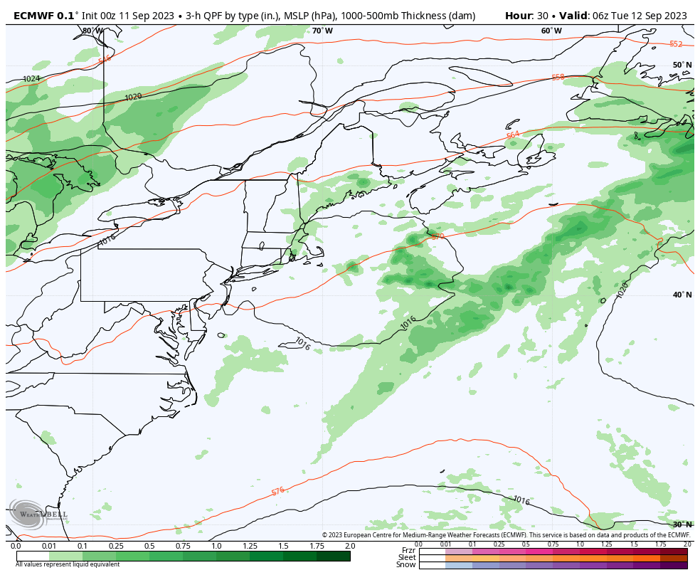
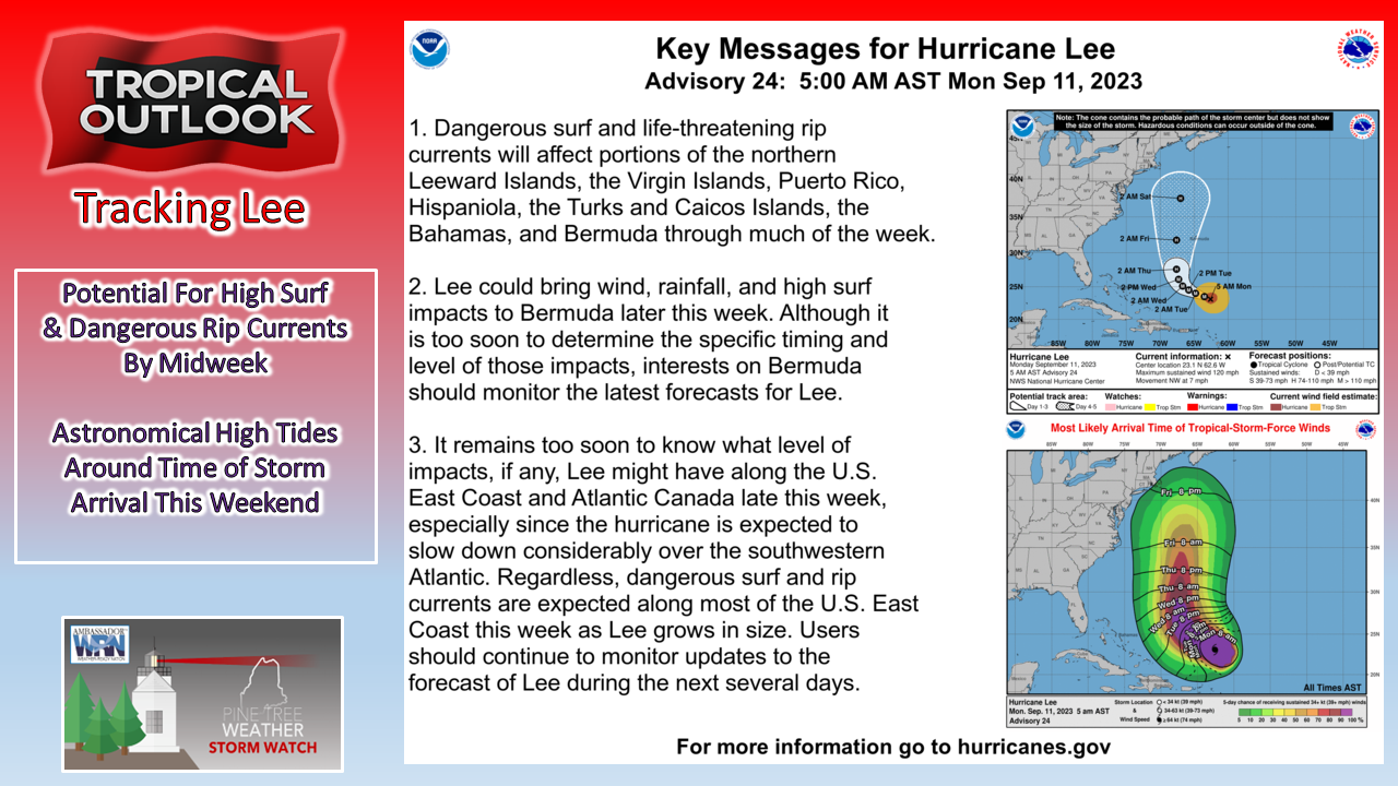
An interesting week ahead

Picture
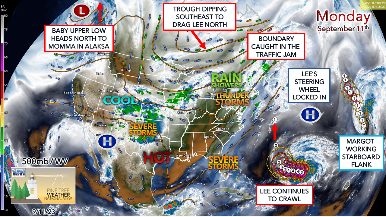
While the main concern is what may potentially happen with Lee, and deservedly so, there are a couple of systems to deal with out ahead of it. Given the humid airmass that is meandering over the region due to the meandering frontal boundary, the risk of heavy rain with perhaps some localized flash flooding is on the discussion table for Monday, and again on Wednesday into Thursday. All of this while long wave swells from Lee arrive and begin to build along the coast. Folks with exposed shoreline property and/or boats should continue to prepare and monitor the forecast as the week progresses. For the rest of us, the main concern is for rain and what impacts that may bring pending on what Lee decides to do. 

Showers and a couple rumbles possible
​for the foothills and coastal plain Monday

Picture
Monday 6 AM to Tuesday 2 AM - Shower activity is expected to increase during the day over the interior during the morning. Coastal areas may deal with a few hit or miss showers early on but see rain chances increase in the afternoon. There could be a rumble of thunder to two mixed in, but the risk is low, and severe chances are very low given the cloud cover. Rainfall could be locally heavy in spots and may cause isolated flash flooding. Showers are expected to continue in the overnight hours into Tuesday. 

Another wave of locally heavy rain midweek

Picture
Tuesday 2 AM to Thursday 8 PM - A weak area of low pressure offshore keeps the risk of showers in the forecast for Tuesday. Low pressure forms along the stalled boundary in a pseudo-inside runner form that tracks into Quebec and drags a wave of rain showers through the region Wednesday that could bring areas of heavy rain, and once again cause some localized flash flooding in spots. Pending on the timing of the frontal boundary passage with dictate if this ends as the model here suggests or slows down allowing rain to continue into Thursday. 
Picture
The general idea of 1-3" is expected for rainfall totals through Thursday, with the western interior likely to have the best chance for 2" or more. With the ground saturated and with little dry time ahead of Lee's arrival it is especially concerning pending on the track. 

Monday 5 AM update on Lee

Picture
I mentioned this on Facebook, and it is worth repeating that tropical systems grow in size as they head northward into the mid-latitudes and this one will as well. It's also worth repeating that the Saffir-Simpson scale of rating tropical systems based on wind speed of the eye only is great for scientific research and analysis but does not properly gauge overall storm impact potential of torrential flooding rainfall, severe storm potential, ocean surf, storm surge, and coastal flooding. 

I am on record here that I do not care what the Saffir-Simpson rating for this storm will be at the time of arrival. My focus will be on impacts from ALL the ingredients, whether it be wind, rain, and the shoreline shenanigans that come along with the complete package.  
Picture
Ensemble means are still locked in with hitting Nova Scotia on the nose, which puts Maine on the wetter side of the storm. With the storm expanding in size, which does increase the wind field, so the region will get some of that as well, just not as strong as on the east side. 

As can be seen here, the individual ensemble members have a wide envelope of ideas. The progressiveness of the upper air pattern will dictate Lee's final approach and what it will deliver for impact to the region. 

It would be wise to prepare for the worst to stay out ahead of it. I've said repeatedly over the years that models are like shady used car salesmen. The operational ideas that get spread on social media cannot be trusted. 

Stay in touch with the National Hurricane Center for the latest information on Lee. 

Don't buy into the hype or the fear. Prepare. Stay tuned. 

Focus on potential impacts,
​regardless of storm size or category

Picture
​Be prepared for hurricanes by knowing how to understand forecasts. They can tell you a lot about what is expected, including the storm’s paths, rainfall amounts, wind speeds, and more. There is a lot of information available days ahead of a storm, and it is important to understand what it means. noaa.gov/understand-forecast-information

Pine Tree Weather is funded from followers like you.
I would appreciate your financial support. 
Click here for how you can contribute.


You may not like the weather, but I hope you like what I do,
and support my efforts.

​
Thank you!

Stay updated, stay on alert, and stay safe!

- Mike

​​NOTE: The forecast information depicted on this platform is for general information purposes only for the public and is not designed or intended for commercial use. For those seeking pinpoint weather information for business operations, you should use a private sector source. For information about where to find commercial forecasters to assist your business, please message me and I will be happy to help you.

Comments
    Picture

    Mike Haggett
    Kennebunk, ME

    Weather-Ready Nation
    Ambassador

    Certified Weather
    Forecaster
    Penn State '21

    American Meteorological Society

    National Weather Association
    ​
    ​SKYWARN-CWOP

    Matthew 19:26


    DONATE

    Picture
    Picture
    Picture
    Picture
    Picture

    Picture

    Picture

    Picture

    Picture

    Picture

    Picture

    Picture

    Picture

    Picture

    Picture

    Picture

    Picture


    Archives

    April 2025
    March 2025
    February 2025
    January 2025
    December 2024
    November 2024
    October 2024
    September 2024
    August 2024
    July 2024
    June 2024
    May 2024
    April 2024
    March 2024
    February 2024
    January 2024
    December 2023
    November 2023
    October 2023
    September 2023
    August 2023
    July 2023
    June 2023
    May 2023
    April 2023
    March 2023
    February 2023
    January 2023
    December 2022
    November 2022
    October 2022
    September 2022
    August 2022
    July 2022
    June 2022
    May 2022
    April 2022
    March 2022
    February 2022
    January 2022
    December 2021
    November 2021
    October 2021
    September 2021
    August 2021
    July 2021
    June 2021
    May 2021
    April 2021
    March 2021
    February 2021
    January 2021
    December 2020
    November 2020
    October 2020
    September 2020
    August 2020
    July 2020
    June 2020
    May 2020
    April 2020
    March 2020
    February 2020
    January 2020
    December 2019
    November 2019
    October 2019
    September 2019
    August 2019
    July 2019
    June 2019
    May 2019
    April 2019
    March 2019
    February 2019
    January 2019
    December 2018
    November 2018
    October 2018
    September 2018
    August 2018
    July 2018
    June 2018
    May 2018
    April 2018
    March 2018
    February 2018
    January 2018
    December 2017
    November 2017
    October 2017

Proudly powered by Weebly