|
A heads up for those who follow this page via Facebook: it would be wise to turn on page notifications if you have not yet done so. Click in the page, there is a quick tutorial pinned at the top that tells you how to do it. It works better if you have fewer page notifications. For those following on Twitter, check my profile to look for the pinned tweet at the top. That will provide my latest update. After this post I am not sure when or where my next update will come. I am wrapping up some much needed down time and will be heading home on Sunday. If I do not update on Sunday, I will provide an update on Monday morning, either here or on Facebook. This discussion should be a good primer, just in case the forecast changes. A breakdown of the storm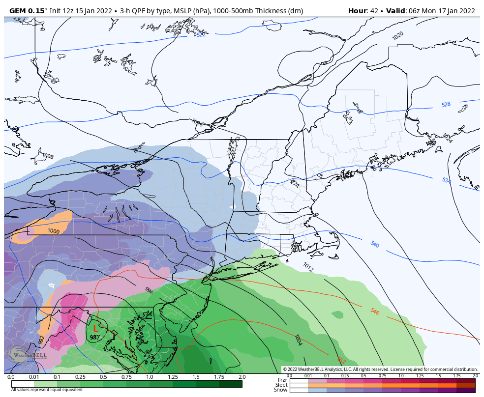 Monday 1 AM to Tuesday 1 PM - Operational guidance has come into a general agreement on timing and track, with the usual individual model idiosyncrasies. The Canadian GEM model idea hits on a point which is important, and that is the potential for mixing over the southwest interior up into the foothills and mountains. This will be a factor in snowfall amounts, as well as snowflake consistency and water composition. Given the idea that this is a close inside runner as the idea stands at the time of this post on Saturday, this is shaping up to be a slop fest over western areas. Heavy, wet, heart-attack type snow is likely here, and it will need to be moved as it will turn to cement as the temperatures drop Monday night as the storm moves northeast and drags cold air in behind it. 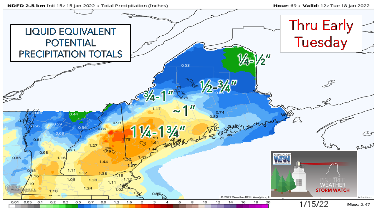 Here's a look at the potential water associated with the storm to get an idea of just how sloppy this is. Anytime an inch or more of water is involved, it generally does not end well between pasty accumulations that stick to everything and potential for power outages as a result of it. Given the sou'easter affect, which is what this is as an inside runner, the wind is very much a concern here... 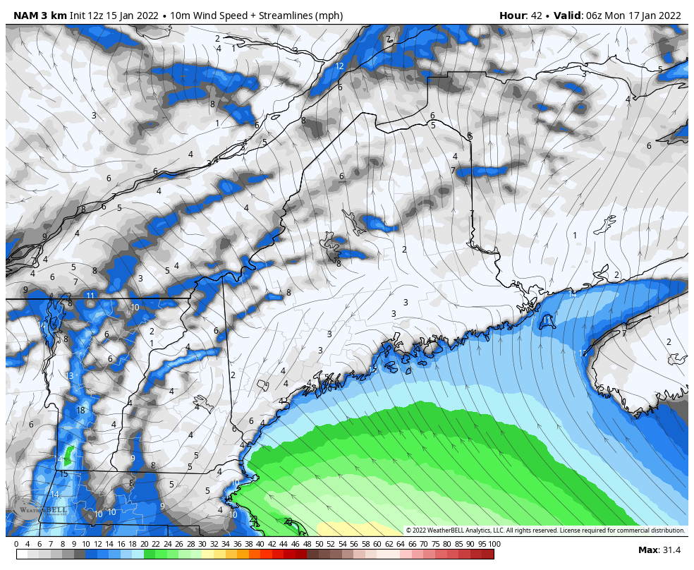 Monday 1 AM to 7 PM - There is potential for a high wind watch / warning and/or wind advisory for the shorelines and coastal plain, and perhaps the western interior with this system. Sustained wind speeds 20-30 mph with gusts 50-60 along the shorelines appears to be a good possibility. The low-level jet stream is likely to sound like a freight train as it howls at 75-85+ knots Monday morning over the southwest coast and continues up the DownEast coast Monday afternoon. The worst of the wind threats appears over by noon south of Portland, mid-afternoon for the MidCoast and by around 6-7 PM Monday evening for DownEast areas. There is a two-level wind threat that should be noted here. There is the horizontal effect from the surface low, and the vertical effect of heavy precipitation. Like we see in summer during thunderstorms where downpours deliver damaging downdraft wind, it is similar here. The strongest wind aloft is in conjunction with the timing of the heaviest precipitation. Whether it is heavy rain or pasty snow, there is the likelihood of power outages as the wind comes in both directions. 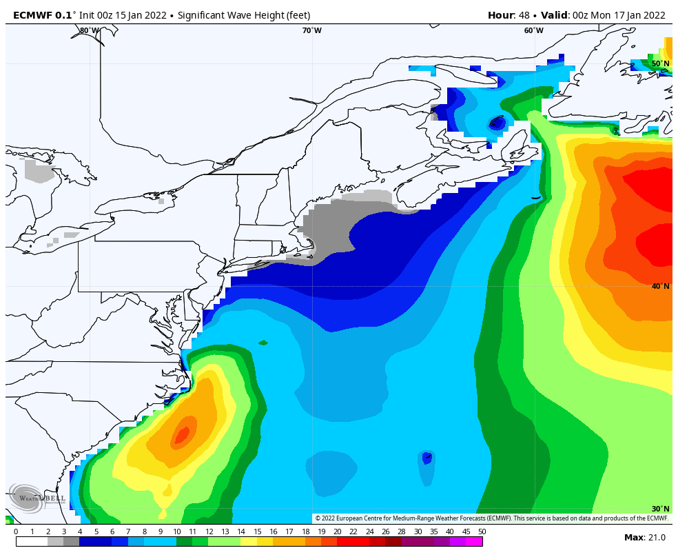 Sunday 7 PM to Wednesday 7 AM - The shorelines are likely to get hammered between the wind and the 12-17' (or higher) surf. The high tide in Portland at 10:41 Monday morning is a concern for splash-over and flooding as the southeast winds push water onshore. DownEast areas may escape the worst of the battering as the tide will be going out when the strong winds crank there. The ocean will be cooking into Tuesday before settling out on Wednesday. 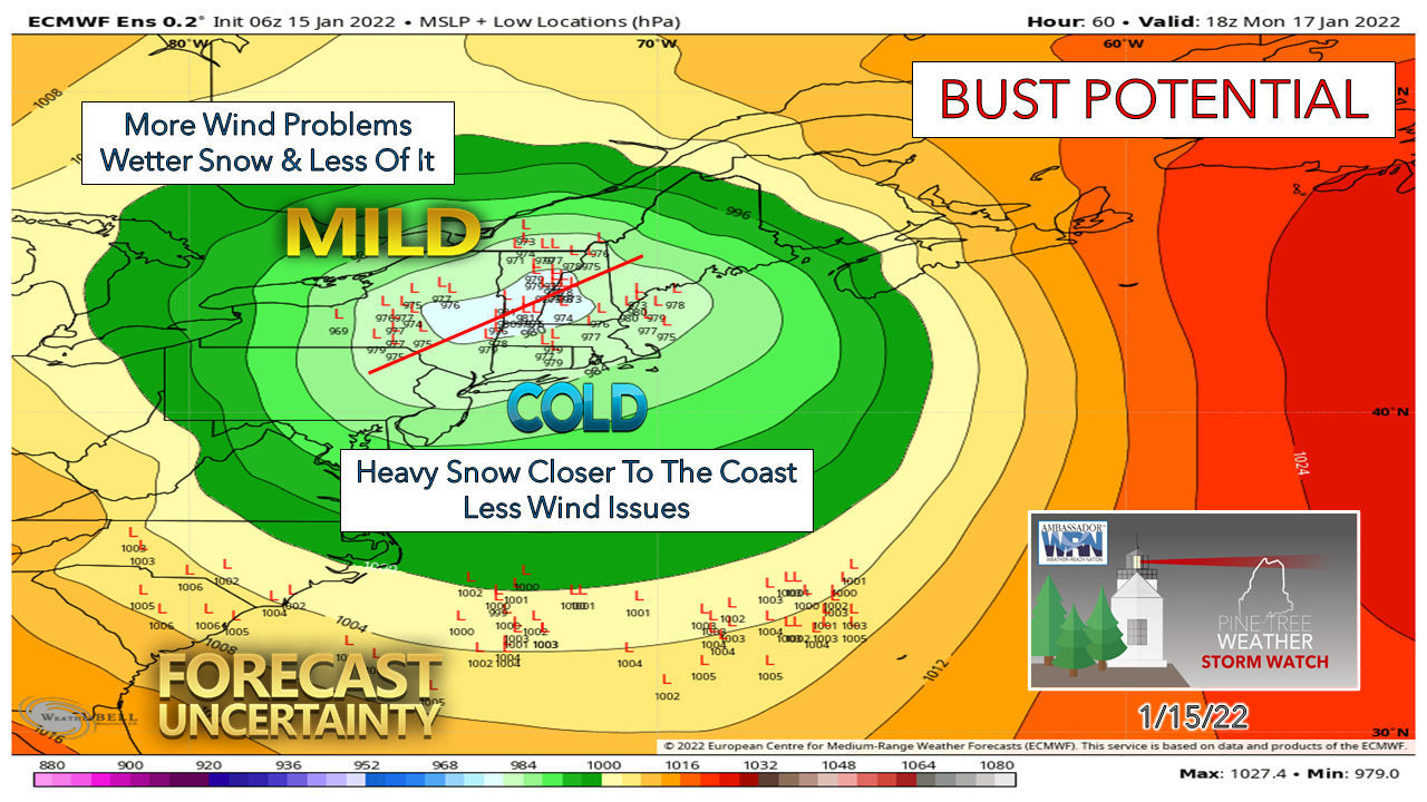 The amount of uncertainty with individual ensemble members this close to a storm is concerning. I drew the red line in to split the ideas to show potential impacts if the storm track works further north (mild) or south (cold) and how the impacts of that may affect the outcome. Bottom line is there is potential for changes to the forecast. Stay tuned! 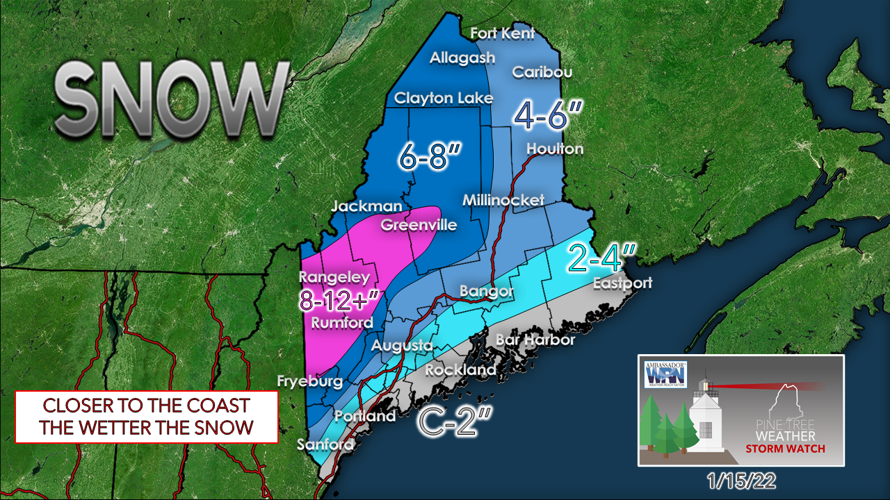 Everyone is likely to see flakes at the onset, including the shorelines. How long it lasts depends on track and timing. If the warm nose aloft reaches further into interior western areas, potential for a period of sleet and freezing rain is there which may knock totals down. Hopefully, this will be a good event for the western interior that is in crying need of snow for the winter sports enthusiasts as well as the water table. For coastal and interior western areas please be prepared for power outages and keep your storm supplies stocked.  Outlook through ThursdaySnow showers are possible for the mountains on Tuesday as the storm moves into Quebec. A weak warm front moves in for Wednesday which may bring light snow to the region. Snow showers are possible again for Thursday as a cold front moves through the area. Potential is there for an ocean storm next weekend.  Staying Warm Without Power When the power goes out in winter, the cold can be deadly--but even without power, there are still ways to warm things up. Closing blinds and curtains and closing room doors can help contain heat, and stuffing towels in the cracks under doors can help keep the warmth in. Don’t forget about eating and staying hydrated - food provides energy to warm the body. Learn more about winter safety: weather.gov/safety/winter Be prepared to receive alerts and stay updated!
 For more information in between posts, please follow Pine Tree Weather on Facebook and Twitter. Thank you for supporting this community-based weather information source which operates by reader supported financial contributions. Thank you as always for your support! - Mike NOTE: The forecast information depicted on this platform is for general information purposes only for the public and is not designed or intended for commercial use. For those seeking pinpoint weather information for business operations should use a private sector source. For information about where to find commercial forecasters to assist your business, please message me and I will be happy to help you.
|

Mike Haggett
|