
Multi-day system brings multiple rounds of precipitation to Maine for Monday through Wednesday.1/3/2021  Low pressure spins off the coast of Maine for multiple days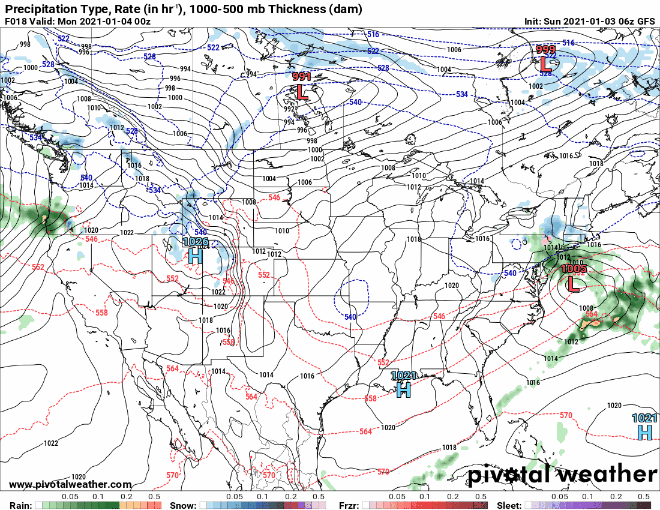 This is a precipitation forecast loop from the GFS from tonight (Sunday) at 7pm to Wednesday at 7pm. A low pressure system, accompanied by a shortwave just off to the west, will move off the New Jersey coast and into the Maine coast tonight and into Monday. The dry, cold air from an arctic high pressure system (outside of this picture) will block the low from advancing forward and cause it to retrograde off of the coast. The retrograding motion on Tuesday will likely bring the majority of the precipitation to Maine, while it's first passage on Sunday night/Monday will bring flurries and light accumulations. This loop is not my official forecast, it's just to give you all a view of the overall system and timing. Flurries and low accumulations on Monday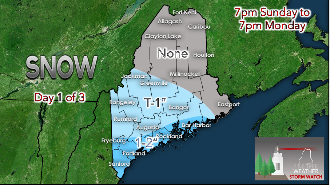 This system is a very dynamic one. There's a lot of factors at both the upper-levels and surface that are coming together, which is making the precipitation difficult to predict. However, I can say with high confidence that Sunday night into Monday will not be a high-impact event. As the low moves off the coast before beginning to retrograde, its initial passage will likely bring some flurries and snow showers to central and coastal areas. I believe that the southern and central coastal plain has a higher likelihood of seeing more snow, with up to 2 inches possible depending on the amount of moisture available from the ocean and the low position. Meanwhile, flurries are more likely across western and central Maine, with any accumulations right around an inch. It is very unlikely that northern Maine sees any precipitation through Monday. The precipitation in the early morning hours of Monday may make roads a bit slick when traveling, so please use caution heading to work on Monday morning. As the day continues, precipitation chances will decrease and some clearing is possible across central and southern regions of the state. Temperatures will rise into the mid 30s in southern regions, lower 30s in central regions and mid 20s in northern regions during the day. However, if there is any lingering moisture in the area as temperatures rise into the mid/upper 30s in southern and coastal regions during the day, there is a slight chance for a wintry mix. This could briefly make roads slick but once the shower passes, impacts should decrease again. Overnight, temperatures will fall into the 20s throughout the state while the next band of precipitation arrives. More snow likely on Tuesday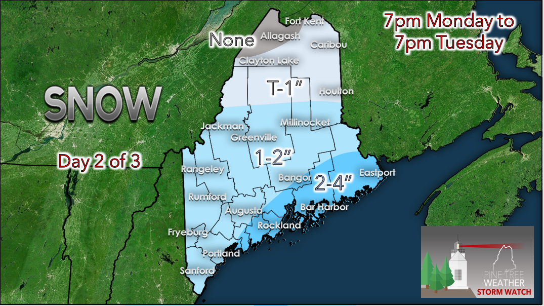 As the low stalls out off of the Maine coast, precipitation bands will likely form and move from northeast to southwest across the state overnight Monday. Many models are suggesting the band to set up in Downeast areas and slowly work its way west, becoming weaker as it progresses. However, I mentioned previously that there is an arctic air mass to the North, feeding in dry air. So, there is uncertainty with how much the dry air impinges on the system and throws off snow totals. Cold air can be very persistent, so I kept totals relatively low with Downeast potentially seeing up to 4 inches. The uncertainty lies within this band and if it maintains enough moisture and energy, the band could produce heavier precipitation that could put totals in the Downeast region up to about 6 inches. I still believe the cold, dry air will dominate though and keep snow totals lower. As the northern portions of the band sweep through the state, central regions could accumulate up to 2 inches. Northern regions may be confined to just flurries, where accumulations up to an inch are possible, while the Allagash area will likely stay dry. Take caution during the morning commute Tuesday morning, as road conditions could again be slick especially in Downeast and coastal areas. Temperatures during the day on Tuesday will be similar to Monday with upper-20s north and mid-30s south. Again, coastal areas have the potential to see a mix during the day as temperatures rise above freezing. Overnight, temperatures will fall back into the 20s with the chance for precipitation to continue in Downeast areas. Potential for lingering precipitation Tuesday night into Wednesday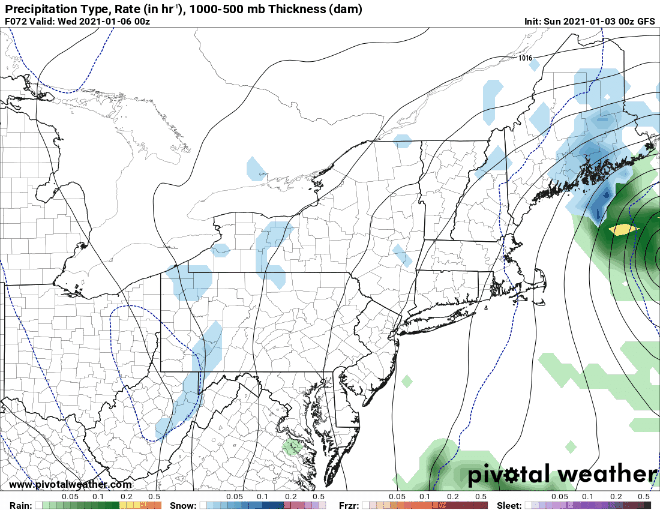 The final piece of uncertainty with this system is the chance for lingering precipitation overnight Tuesday into Wednesday. I still think the cold, dry air will begin to impinge on the area and keep further precipitation totals under or at an inch. However, there is the chance that the low maintains enough moisture to continue to snow over Downeast areas, bumping up snow totals to around 6 inches. Some models show precipitation persisting into the day on Wednesday, with another band setting up and higher chances for a mix. Kaitlyn and Mike will have more on this during their next posts! Stay tuned. Winter driving safety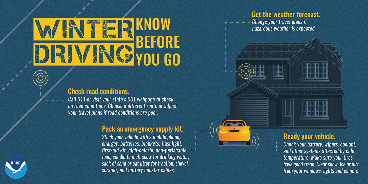 Though I've mentioned that this event will likely be low impact, it's still important to remember winter driving safety, especially when precipitation may occur during heavily trafficked hours! Double check the forecast before you head out and you can even call 511 or visit http://newengland511.org/ to see current traffic conditions throughout New England. I understand that many of you would not be able to change your departure time due to inclement weather if you're trying to get to work, so don't forget to take it extra slow! Also, make sure to have your car prepped with the appropriate tires, windshield wipers, fluid and other tools you may need. Being a New Englander myself, I've found that Rain-X de-icing windshield wiper fluid has been extremely helpful in clearing off my windshield on those cold, icy mornings. Stay safe out there! Be prepared to receive alerts and stay updated!
For more information, please follow Pine Tree Weather on Facebook and Twitter.
** FUNDING NEEDED FOR 2021 ** Thank you for supporting this community based weather information source that is funded by your financial contributions. Stay updated, stay on alert, and stay safe! Have a great start to your week! - Alex |

Mike Haggett
|


