|
The year 2021 is now in the books and since you are reading this, congratulations for making it this far. These past couple of years have been challenging to say the least. Looking ahead to 2022, this marks ten full years since I began my meteorological quest for understanding the atmosphere. My cynicism and disrespect of the past for forecasters has been replaced with nothing but utmost respect as time goes along. This blue-collar peanut-whistle operation continues to grow slowly, for which I am most grateful. I am honored to have financial support from those who follow here and believe in what I do. It makes the 2 AM wake-up calls worth it. When I say that I thank you for your support, I mean it. I work hard to earn it, and work hard to keep it. I pray that we all stay healthy and take care of ourselves for better times ahead. A damp and dreary start to the year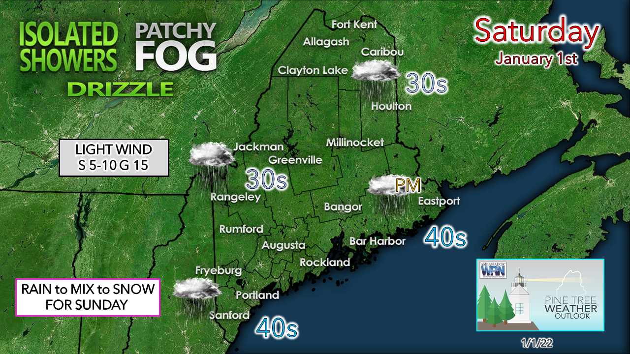 One more day of more of the same, with areas of fog, drizzle and showers for much of the region. Eastern areas stay generally dry outside of some patchy drizzle until later today. Winds are generally light, with temperatures well above normal to start the year. 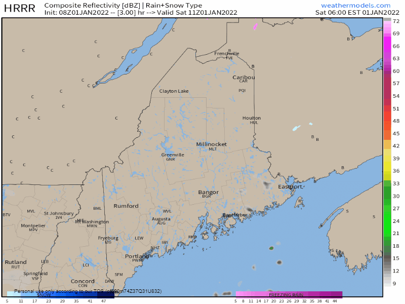 Saturday 6 AM to 7 PM - HRRR futurecast radar idea shows a few showers around through the course of the day. I can't rule out some spotty freezing drizzle in the north, but the moose may be the only ones that deal with it. Temperatures appear to rise above freezing, even if by a degree or two, for most of the region. For those travelling today, watch out for locally dense fog reducing visibility. 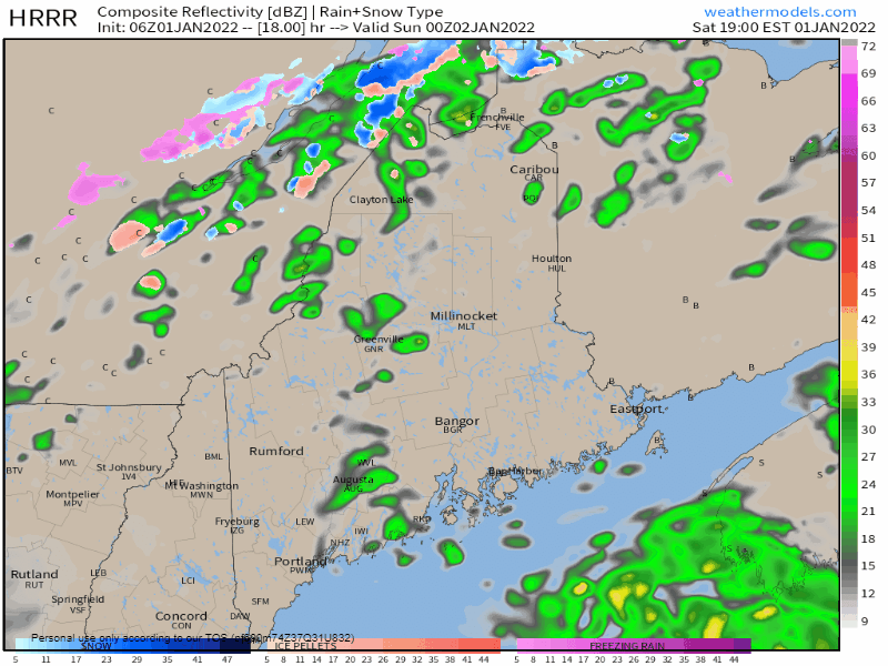 Saturday 7 PM to Sunday 7 AM - A long wave cold front slowly advances eastward. Expect a transition from rain shower to sleet and/or freezing rain, then to snow for the mountains and foothills heading into Sunday morning. This could generate some slick spots for the early bird travelers, so be aware of that if you are heading out for work or play. The high temperatures of the day are likely to be established around midnight for much of the region. As the cold front moves through, temperatures drop through the day for all but southern areas. Snowflakes for all Sunday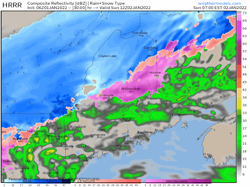 Sunday 7 AM to Monday 1 AM - As the front passes through and temperatures in the air column cool, rain and wintry mix changes to snow for all during the day. There is concern with the falling temperatures of flash freeze and black ice potential in areas that see rain and see the sharp transition to mix and then snow as the frontal boundary moves eastward during the afternoon. It would be a good idea to stay home unless travel is absolutely necessary as temperatures crash toward evening. 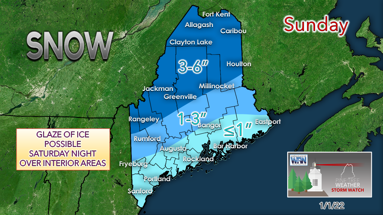 With the charge of cold air working in, it's also very dry which will fluff the snow and cut down amounts that fall. Northwest Aroostook has the better chance of seeing 5-6" with isolated higher amounts possible. Overall, this storm appears to be manageable to handle.  A quick hit of cold for Monday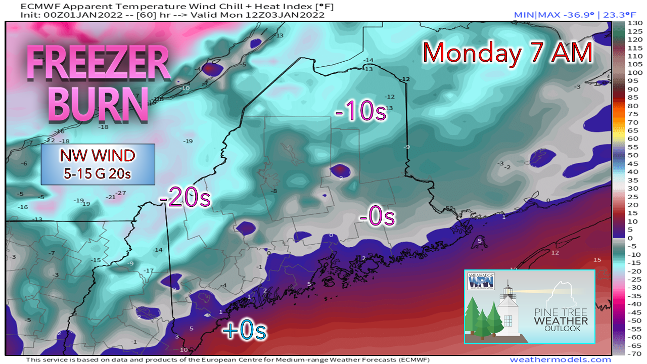 While it does not appear to be windy of any great concern, what breeze that comes in conjunction with the airmass associated with it will be a bitter cold one. The wind diminishes from west to east during the day, modifying the bite of the air somewhat, but it appears to be a day to bundle up and keep the wood stove going. This shot of cold will be short lived as high pressure associated with it moves to the east and temperatures modify heading into the middle part of the week. Temperature forecast and outlook through late weekA roller coaster ride of high and low temperatures as the chill hits the first of the week and then as ridging noses in, warms temperatures back up above normal by Wednesday. As the warm air intrudes and a cold front quickly approaches to cut it off, snow / mix / rain is possible for Wednesday, and another potential storm is possible for Friday. An active pattern continues. Stay tuned! 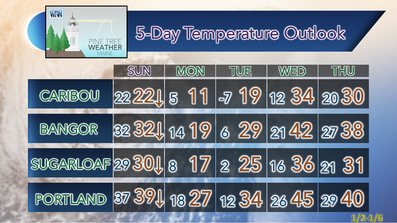 Rain with a Temperature Near Freezing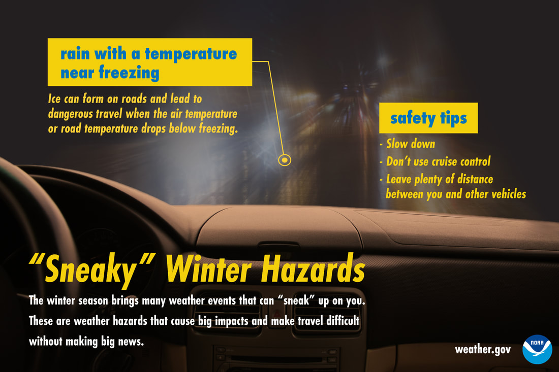 Rain may seem less of a winter driving hazard than snow, but when temperatures are near freezing, that’s not the case. Ice can form quickly and make roads slick. In these conditions, slow down, don’t use cruise control, and keep plenty of distance between you and other vehicles. Don’t let this winter hazard sneak up on you! Be prepared to receive alerts and stay updated!
 For more information in between posts, please follow Pine Tree Weather on Facebook and Twitter.
Thank you for supporting this community-based weather information source which operates by reader supported financial contributions. Stay weather aware, stay on alert, and stay safe! - Mike |

Mike Haggett
|