
Long duration eventAll of the pieces have fallen into place here. What once was trending cooler is back to trending warmer again with a more westward track closer to the coast. The mountains are on track for a decent snow. The closer to the coast, the more rain comes into play, and plenty of it. The main forecast idea of a heavy, wet slop that could bring power outages, cause dangerous travel on the roads, along with potential cardiac arrest trying to shovel it continues for the coastal interior on up south of the mountains. 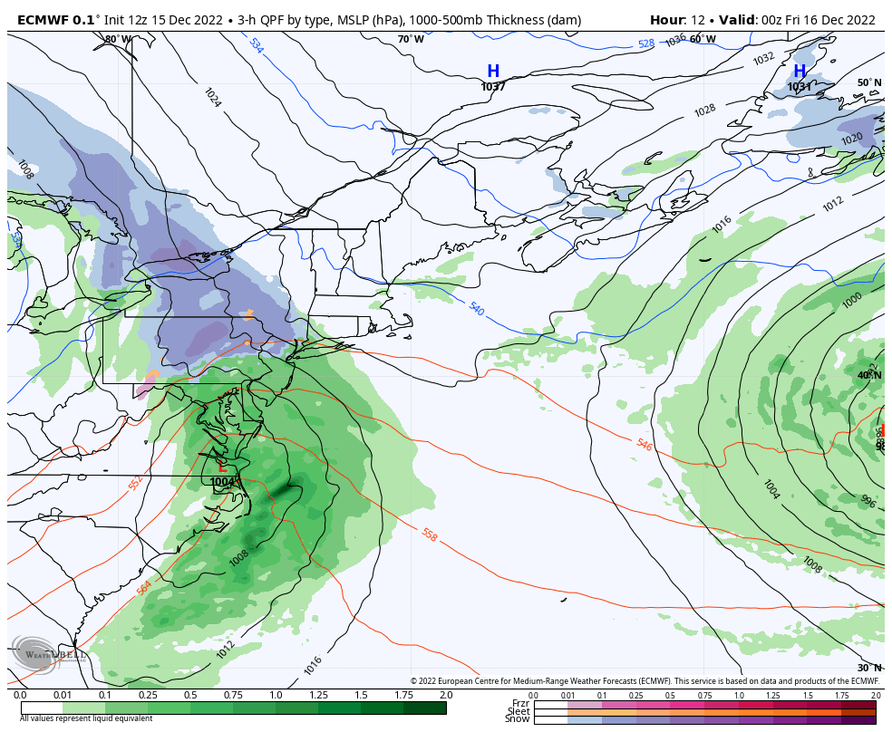 Thursday 7 PM to Monday 7 AM - The mountains are set for a multi-day snow event starting Friday and Saturday with the bulk of the snow and snow showers continuing all the way through Tuesday. The north gets in on the action Saturday and sees snow showers continue there through Tuesday. Eastern areas get in the game Friday afternoon and sees snow showers continue there through Monday. The south has it narrowed down to a two day event Friday and Saturday. Timing through Sunday 1 AM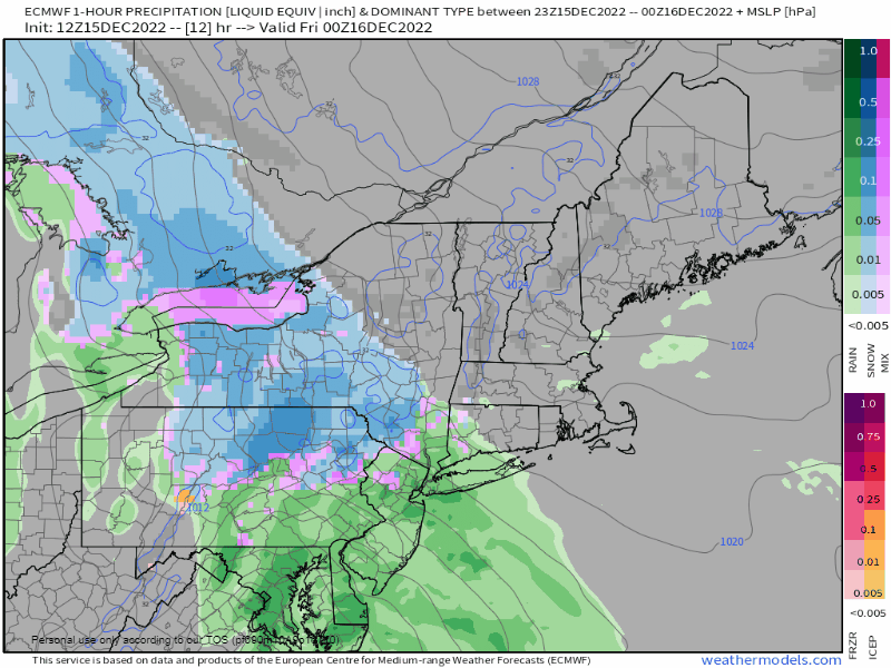 Thursday 7 PM to Sunday 1 AM - Any snow that happens to fall over southern areas overnight quickly changes to rain thanks to the ocean temperature in the mid to upper 40s with the east/northeast wind. The idea of influence of cold air damming over the coastal interior has waned somewhat with high pressure situated further east, so surface temperatures are, for now, expected to be warmer. While I expect some accumulation of snow over the mountains and western interior during the day Friday, it appears that it will pile up in earnest Friday night into Saturday morning as the temperature cools below freezing and the storm moves into the Gulf of Maine. By Saturday morning it will be a winter wonderland for the mountains with upwards of a foot of snow by dawn. As the center of low pressure moves towards Penobscot Bay late afternoon, the faucet shuts off over southern areas, with many areas getting 2" of rain. By that point, snow will be falling at a decent clip over The County, and that continues overnight into Sunday. Strongest wind gusts move through early Saturday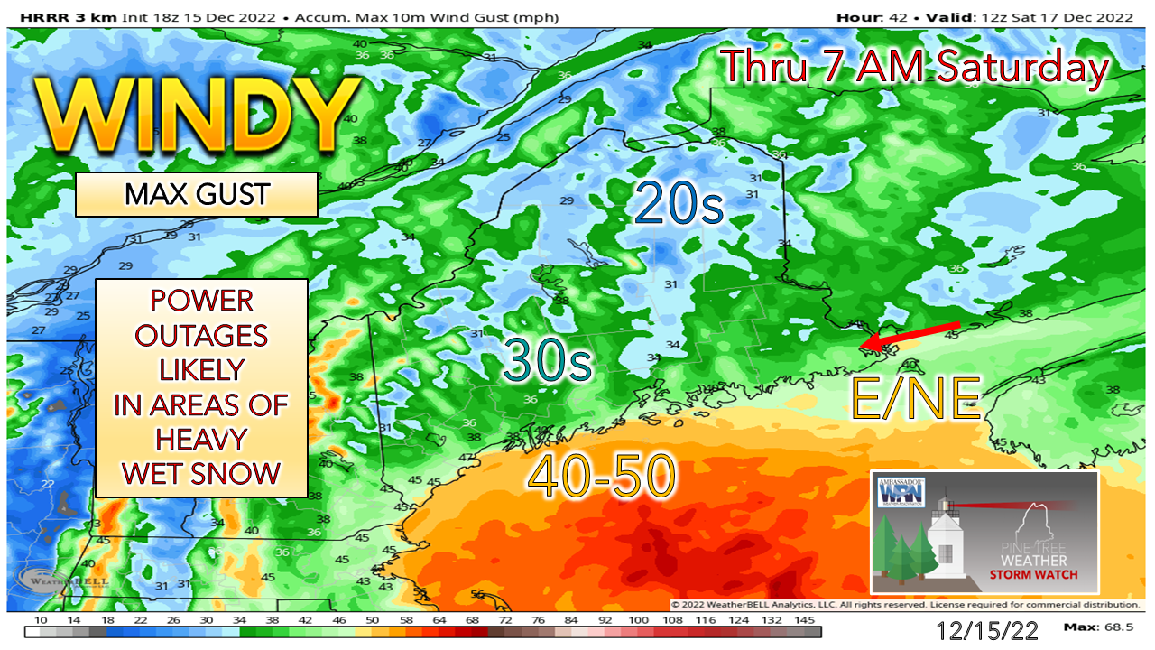 The low level jet ahead of the low brings the chance for the highest wind gusts starting Friday afternoon over the south and continuing up the coast Friday night into DownEast areas. As the storm moves into the Gulf of Maine it begins to weaken, thus the wind speeds settling down somewhat, but it will remain breezy with gusts in the 20-35ish mph range through Saturday. The main concern for power outages is overnight Friday into Saturday morning over the southwest interior. Temperatures are expected to rise above freezing in the areas that receive the heavy wet snow which should clean trees and powerlines up before temperatures fall below freezing overnight into Sunday. Snowfall map revised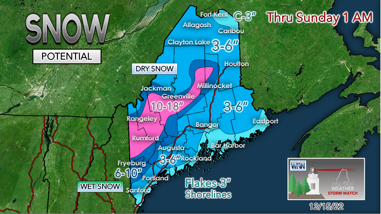 I mentioned in Wednesday's update that the snowfall map is a moving target, and for areas south of the mountains and east, that continues to ring true. Bust potential remains high for the coastal interior from the southwest on up through Bangor. While there are still hints of potential cold to possibly bring additional accumulation, the bulk of ideas trend to lower amounts. It's a tricky call for Lewiston, Augusta and Bangor. I think Portland is mainly rain with this storm with just a narrow window for a few flakes early Friday morning. My ideas are vastly different from NWS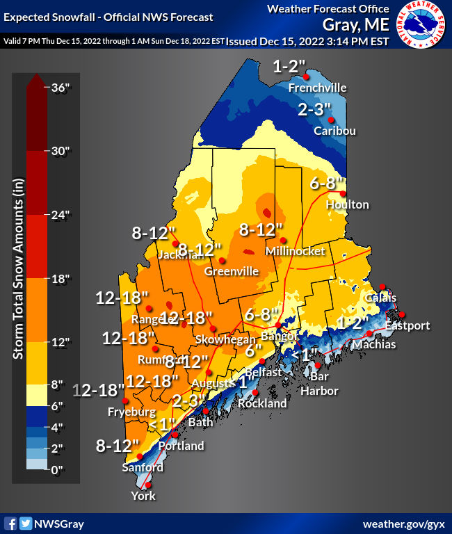 As I was writing this update, the fine folks at the National Weather Service Gray office updated their forecast package. I have the utmost respect for these folks, even when I disagree with their ideas. What I do here is not to undermine what they are doing there. I feel that it is important that you know what they are thinking. You can click here to get their discussion about this event, where they feel the outcome is expected to be colder and more impactful as a result. This forecast really is a tough call for the many reasons I have outlined over the past few days. This will be very interesting to watch unfold. Stay tuned.  Forecast outlook through TuesdayFRIDAY WINTER STORM WARNING FOR THE MOUNTAINS HEAVY WET SNOW POTENTIAL WIND INCREASING DURING THE DAY INTO OVERNIGHT SATURDAY TRAVEL IMPACT CONCERNS POWER OUTAGE POTENTIAL South, Mountains, MidCoast: Precipitation begins early Friday, expands northeast by midday North & East: Mainly cloudy with precipitation beginning Friday afternoon into the overnight Saturday Wind: E/NE 5-15 G20-30 for the interior, 30-40+ coast / mountains Lows 20s for most, 30s along the coast Highs 20s northwest Aroostook / mountains, 30s foothills, northeast Aroostook, around 40 southwest shorelines Windchill 10s/20s/30s SATURDAY WINTER STORM WARNING THROUGH MIDNIGHT FOR THE MOUNTAINS HEAVY WET SNOW POTENTIAL WIND CONTINUES TRAVEL IMPACT CONCERNS POWER OUTAGE POTENTIAL Precipitation continues through the day, ending Saturday night over the south. Snow showers continues for the north, mountains and east into Sunday. Wind: NE 5-15 G20-30 shifting NW 5-15 G20s over the west & south in the afternoon. Lows in the 20s North & Mountains, 30s elsewhere Highs in the 30s for most, around 40 along the southwest coast Windchill 20s/30s SUNDAY BREEZE SETTLES THROUGH THE DAY SNOW CONTINUES NORTH, MOUNTAINS, EAST North, Mountains, East: Occasional snow, ending overnight Monday South: Mostly Cloudy with a chance of a snow shower, sunny breaks possible late day Wind: NW 5-15 G20-30 Mountains & South, NE 5-15 G20 North & East Lows in the 20s for most, around 30 east Highs in the 20s for the mountains, 30s for most, around 40 along the shorelines of the southwest coast Windchill mainly in the 20s MONDAY BREEZY CONDITIONS STATEWIDE Mountains & North: Mainly cloudy with a chance for snow showers East: Morning snow showers possible with gradual clearing South: Sun & clouds Wind: NW 10-20 G25-35 (mountains 40+) Lows in the 20s for most Highs in the low 30s north and mountains, mid-30s to around 40 coastal plain Windchill 10s/20s TUESDAY BREEZY CONDITIONS STATEWIDE Mountains & North: Mainly cloudy with a chance for snow showers South & East: Mix of sun & clouds Wind: NW 5-15 G20s (mountains 30s) Lows in the teens for the mountains, 20s elsewhere Highs in the 20s for the mountains and far north, 30s elsewhere Windchill +0s/10s mountains, 20s elsewhere Thank you as always for your support! If you like what I do, please hit the like button on Twitter and Facebook, and please share! Stay updated, stay on alert, and stay safe! - Mike NOTE: The forecast information depicted on this platform is for general information purposes only for the public and is not designed or intended for commercial use. For those seeking pinpoint weather information for business operations, you should use a private sector source. For information about where to find commercial forecasters to assist your business, please message me and I will be happy to help you. |

Mike Haggett
|


