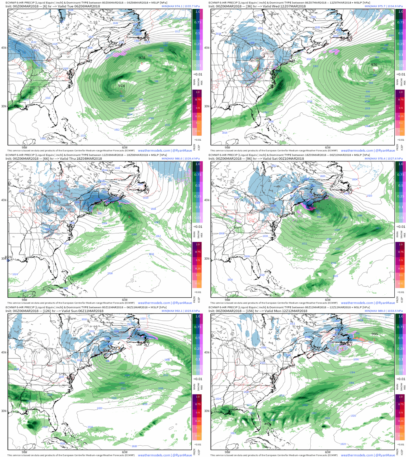
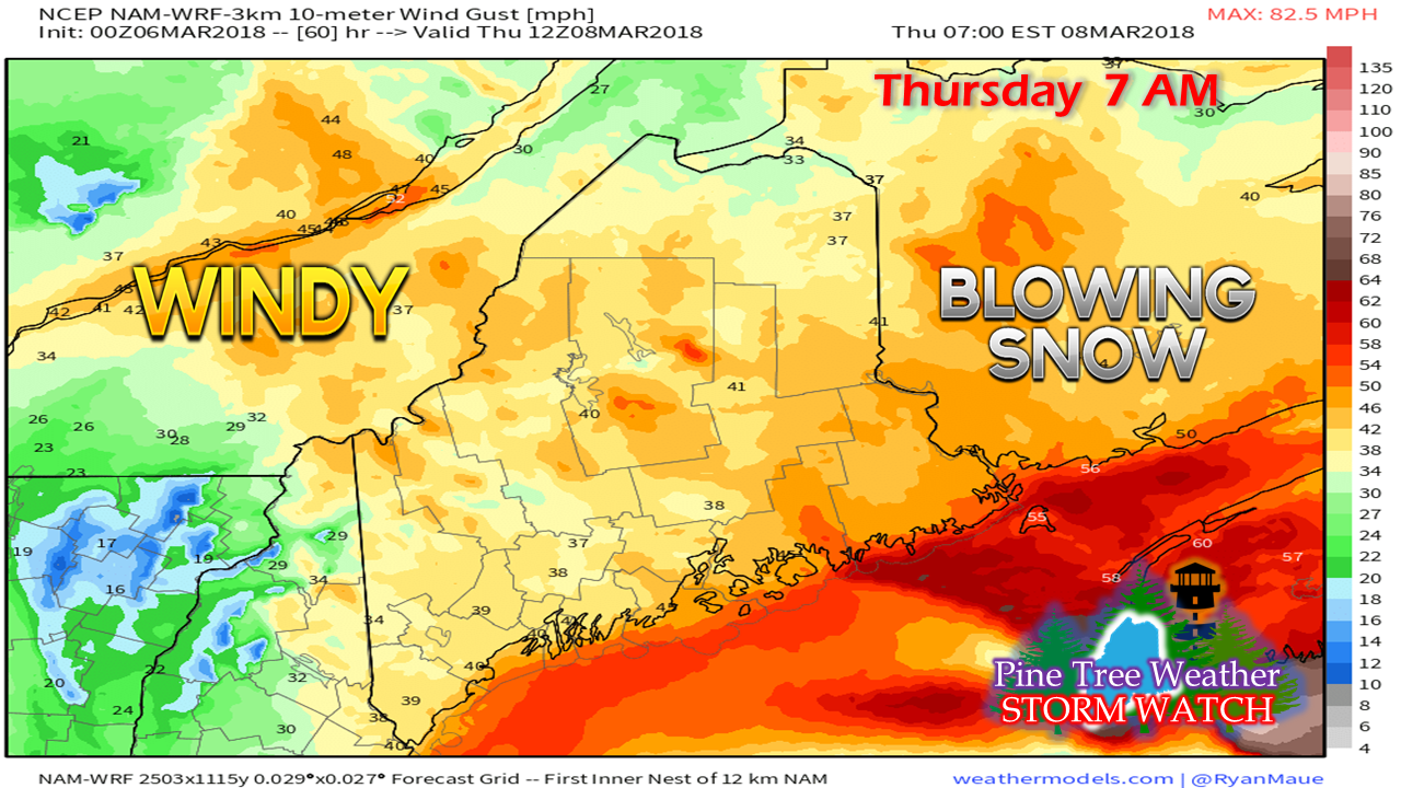
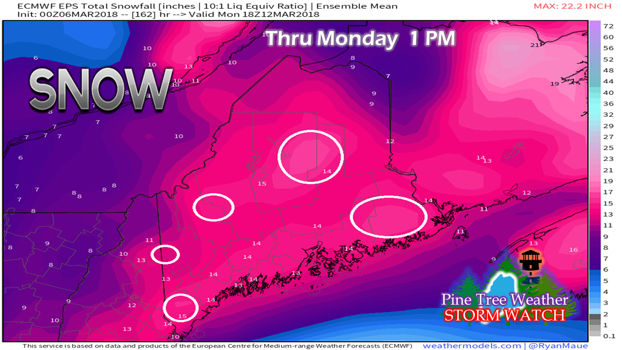
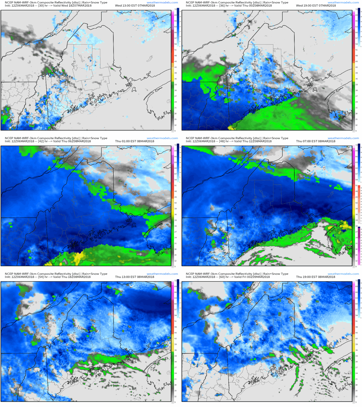
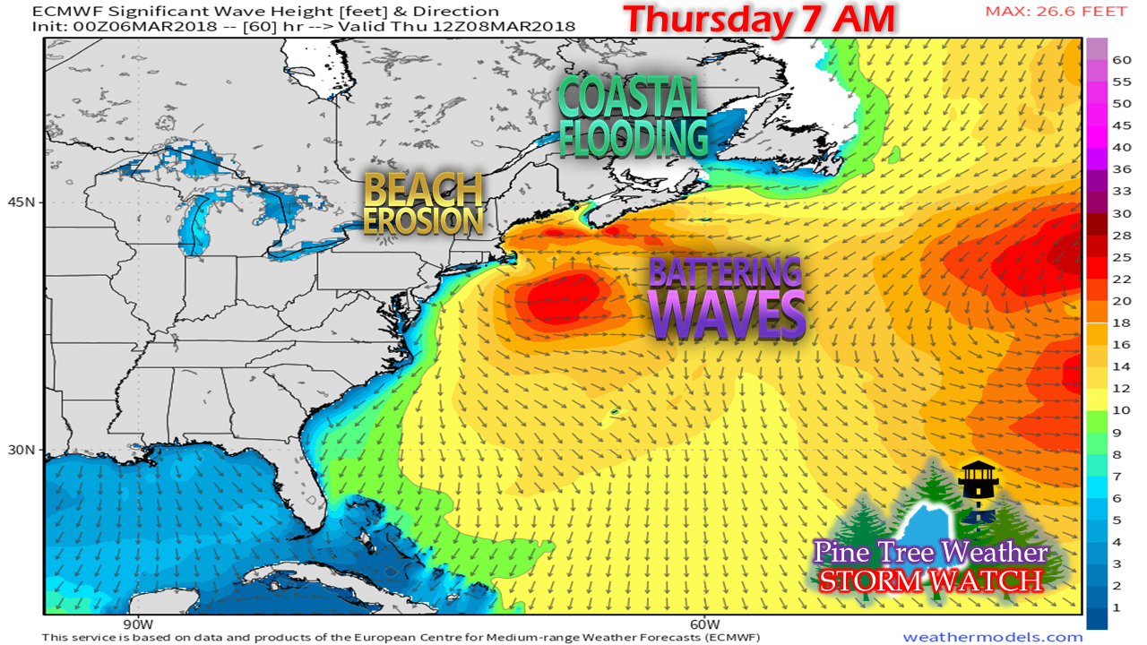
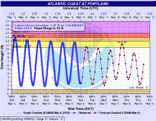
Winter Storm Warning now in effectI am going to get right out in front of this because there is potential for this to get out of hand. Not only that, this could turn into a long duration event, especially for eastern and northern areas of Maine. You'll have to forgive me here for not being as sharp with this one, as I am juggling a lot between the purchase and sale of homes, real job requirements, and family on top of it. I do get the impression there is a skunk in the barnyard, because models handle occlusions (when cold fronts overtake warm fronts) very poorly. A hat tip to crankyweatherguy for bringing this to the forefront. If you are on Twitter, he's a good man to follow, and sharp as a tack on synoptic forecasts like this one. About that "long duration event"...While this is only one model representation, the surface map indicates a pseudo-Fujiwara effect scenario occurring over the region toward the tail end of the loop in the Friday-Saturday time frame. The initial storm makes landfall, curves into northern Maine, a trailing low to the west combines with the parent low, and a trailing low that blossoms around Bermuda siphons off the energy of the two areas into a new coastal low that slams into Nova Scotia. That storm tracks into the Bay of Fundy near Eastport, then moves eastward. This keeps snow and wind in the forecast through the weekend. Blocking to the north and east is what will hold this pattern in place. All of the upper level energy with the incoming storm is just going to spin around and regenerate surface lows which will cause this to happen. Now the "blizzard" part of this...Now that everything is coming into focus, the wind speeds are starting to amp up. I will be the first to admit that the NAM model depicted here has a tendency to overdo wind speeds, but I cannot dismiss the idea that this has potential. A rapidly intensifying system on track to make landfall along the DownEast coast could very easily set up the potential for blizzard conditions for the coast and coastal interior. By those areas, I mean Fryeburg to Waterville to Bangor to Calais to the shorelines. Whether or not it will be an actual blizzard (wind greater than 35 mph for a three hour period with visibility 1/4 mile or less) is a very fine line, but it certainly has potential to do so. Thursday is shaping up to be an absolute bear. Expect widespread cancellations, and if you can take the day off from work, it would be a really good idea to do so. Plow crews are going to have a hard time keeping the roads cleared with the heavy snow and gusty winds that will blow it around. Power outages from the snow and wind are going to be another concern as well. More thoughts on snowThis is the ECMWF (Euro) ensemble outlook for snow through Monday at 1 PM. I have five circles highlighted on here of areas (or in the vicinity thereof) that I think could reach upwards of 20" of snow by the time the weekend is COMPLETELY over. This area includes interior York County, Sunday River, Sugarloaf, Katahdin and interior Hancock and Washington County. Western areas see the bulk of this with the initial storm Wednesday into Thursday. Eastern areas get a solid thump from the initial storm, but have a second storm to deal with over the weekend. Outside of the northeast corner of Aroostook and the northwest corner of Oxford County near Wilson's Mills / Aziscohos Dam area, a foot of snow is a good bet at this point. It could go higher than that with heavy banding that is likely to occur. It could go lower than that in areas where the wind blows it away. For the shoreline areas, I think at this point for Rockland / Portland area that any influence of a coastal front bringing rain will be short lived. Shorelines from around Wells to Kittery may see it hang on a bit longer, but 10-14" is likely the end result there with the dynamic cooling that is forecast to take place. Once the snow begins in earnest, expect it to pile up quickly. One to two inches per hour, perhaps more pending on heavier bands. Timing of the stormSnow begins to arrive over southwestern areas early in the afternoon and then spreads northeastward through the afternoon and early evening. This will likely impact the evening commute as snow begins to pile up around 5 to 7 PM from the Portland area south. Points north (Lewiston, Augusta, Bangor and beyond should be alright getting home, but snow appears to accumulate on surfaces by early to mid-evening. For northern areas, you'll see snow arrive between the wee hours and daylight Thursday. End times depend on region. Southwestern zones see snow taper to snow showers by mid to late afternoon. Eastern Maine appears to be early to mid-evening. I expect snow showers to continue for western and northern areas through the night and into Friday morning. Some areas may see a bit of a lull, but more snow is on the way with the trailing storm on the way Friday night into Saturday. Snow and snow showers appear to persist with that feature through the weekend. More coastal battering...With this system comes more punishment for an already battered shoreline. The high tide to be concerned about will occur during the 3 AM hour Thursday morning. With a bit of storm surge, it won't take much to cause some minor flooding in Portland and vulnerable areas along the southwest coast. The second high tide occurring around 4 PM Thursday does not appear to cause issues, but it would be wise to stay tuned in case it does. Areas impacted from recent flooding should be on alert where the ocean has impacted barriers, sea walls, and roadways. Please check in with the National Weather Service for the latest marine forecasts for the MidCoast and southwest coast and DownEast areas. Stay updated on this storm!Given the fact that this is a significant event, it would be wise to stay updated on the latest official forecast information from NWS Gray for western and southern areas, and NWS Caribou for the latest on northern and eastern areas.
Be prepared for this event... make sure you are stocked up on essentials, prepared for power outages, and fill up the gas tanks in your vehicles by Wednesday evening. Also, be prepared for unexpected surprises. Follow me on Twitter @WesternMEwx - Mike |
Mike Haggett
|

