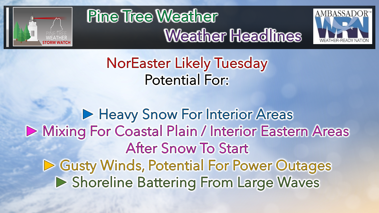
 The fine details on the storm still need to get ironed out, but there is the likelihood of widespread impacts in all corners of the state. If you have to travel on Tuesday, expect it to be a slow one with slick roads, and low visibility from potential whiteout conditions. What I present here is NOT the final answer, but as of early Saturday morning, the best idea I can generate. Expect changes to the forecast, and potential surprises the day of the event. Nothing is carved in stone yet. The pieces that make up the storm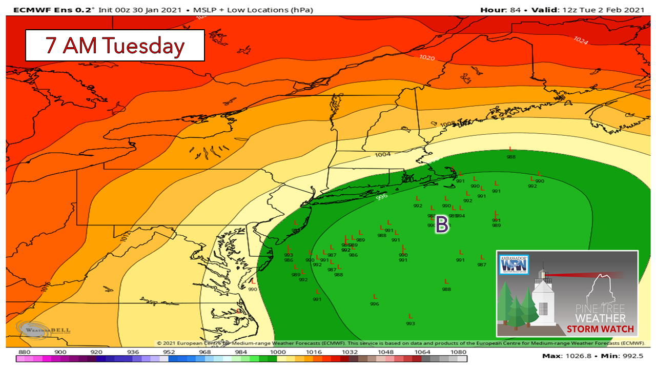 For those that have followed along over the past couple of days, I've presented this chart to show the ensemble layout of the individual 51 members of the European model to show potential track and timing variations. Where in yesterday's post the members were south and east of the benchmark point (40° N / 70° W), the trend to this point has been north and west. The location on the lows are widely scattered here as the individual members disagree on where the pieces of the storm come together. Why is that? There is a shortwave piece over the Canadian Prairies that the timing of it's arrival is still in question. Whereas in this same chart here yesterday indicated a more southeast grouping, it was because that shortwave accelerated quicker to arrive and help drive the storm more out to sea. That idea has backed off for now, and consequently a more northwesterly track is in play, which brings the mountains and north back into the picture for snowfall. With the shift in ideas defined, the actual track and intensity is still to be figured out due to timing, which that will begin to come into a better view by Sunday morning. 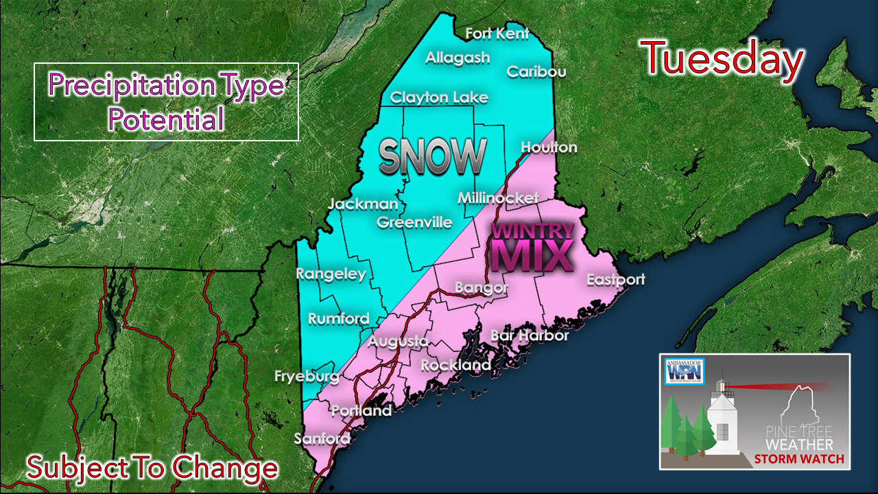 With a more northwesterly track idea in mind here, that brings the mixed bag scenario into play for the coastal plain and eastern areas of the state. A storm track into the Gulf of Maine brings the mix, whereas a track over Nova Scotia brings a snowy affair for all. For now, I am thinking the mix idea is going to come into play here. 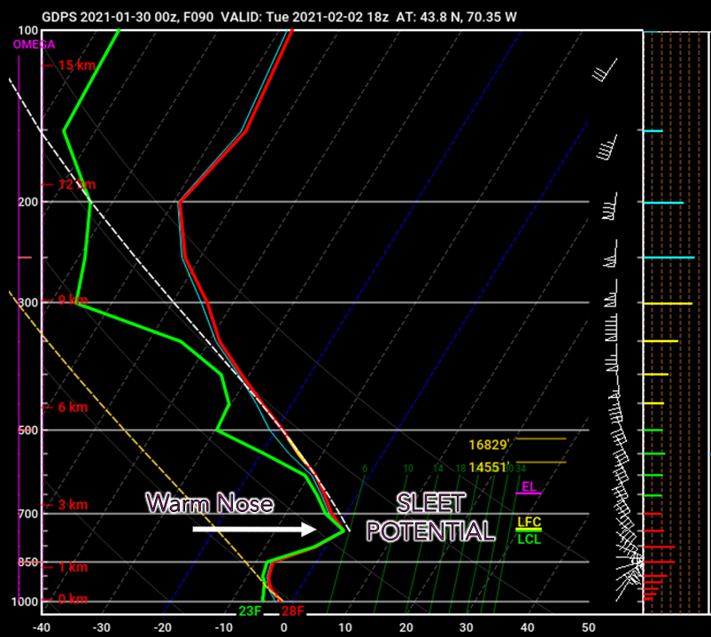 This is a look at a sounding idea, also known as a SKEW-T graphic. With the track potentially coming into the Gulf of Maine, that increases the likelihood of warm air coming in aloft. This idea depicts that notion well. Snow growth is good the onset of decent, but the warm nose could poke in and turn the snow to liquid, then refreeze to form sleet as it heads to the surface. This will impact snow totals where it falls, not to mention make roads and walkways extra greasy. 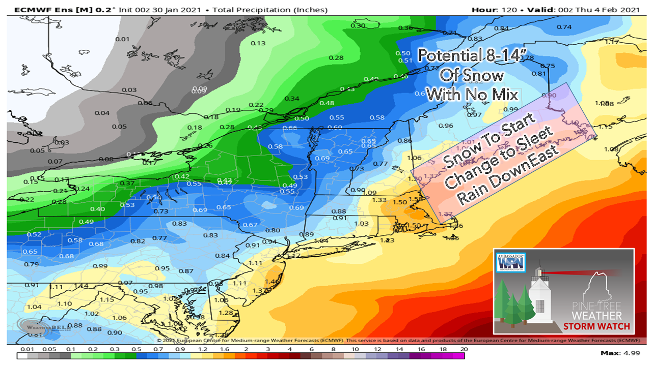 At this point, it appears that the storm could bring roughly 1" of liquid equivalent precipitation with it. A rough draft idea on snow indicates potential for 8-14" of snow for interior areas where mixing does not occur. For the coastal plain, precipitation starts as snow then changes to sleet, perhaps pockets of freezing rain then potentially rain for eastern Washington County. Since timing is still to be ironed out, it's not fair for me to say just how much snow will fall before the change. It appears that it will be enough for road crews to move and treat. For those looking at model charts with snowfall ideas, here's a pro tip for you: sleet messes them up big time, They overestimate snow by a long shot. Don't trust them. If there is bust potential in precipitation amounts, how quick the storm intensifies may bring dry slotting into the picture and lower totals that way. 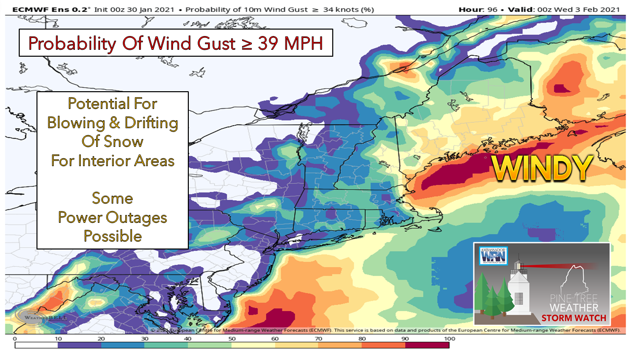 With all of this comes the concern for wind. Coastal areas have a fair chance of seeing 40-50 mph gusts, if not higher, and interior areas could feel it also. A track into the Gulf of Maine brings wind further inland. With the wind, potential for warm air intrusion for the coastal plain, there could be areas of heavy wet snow which sticks to trees and power lines, and we know that does not end well. It would be a good idea to check your supplies and pick up what you need over the weekend in case power is lost for a day or two. 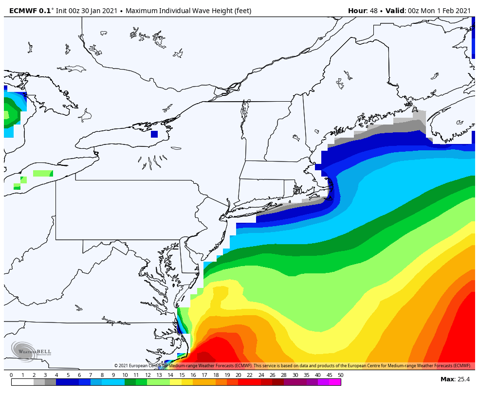 The other concern here is for the shorelines. Strong storms in the Gulf of Maine bring surf and storm surge. The high tide to be most concerned with is the 2 PM hour on Tuesday. Astronomical tides are waning, but still in play here. Seas are forecast in the 13-18' region for now, and may go higher or lower, pending on how this plays out. Beach erosion and splash-over are possible, and there is potential for minor flooding. More information and links to marine forecasts are provided on the marine page here on the website. Stay tuned for updates.  Winter Precipitation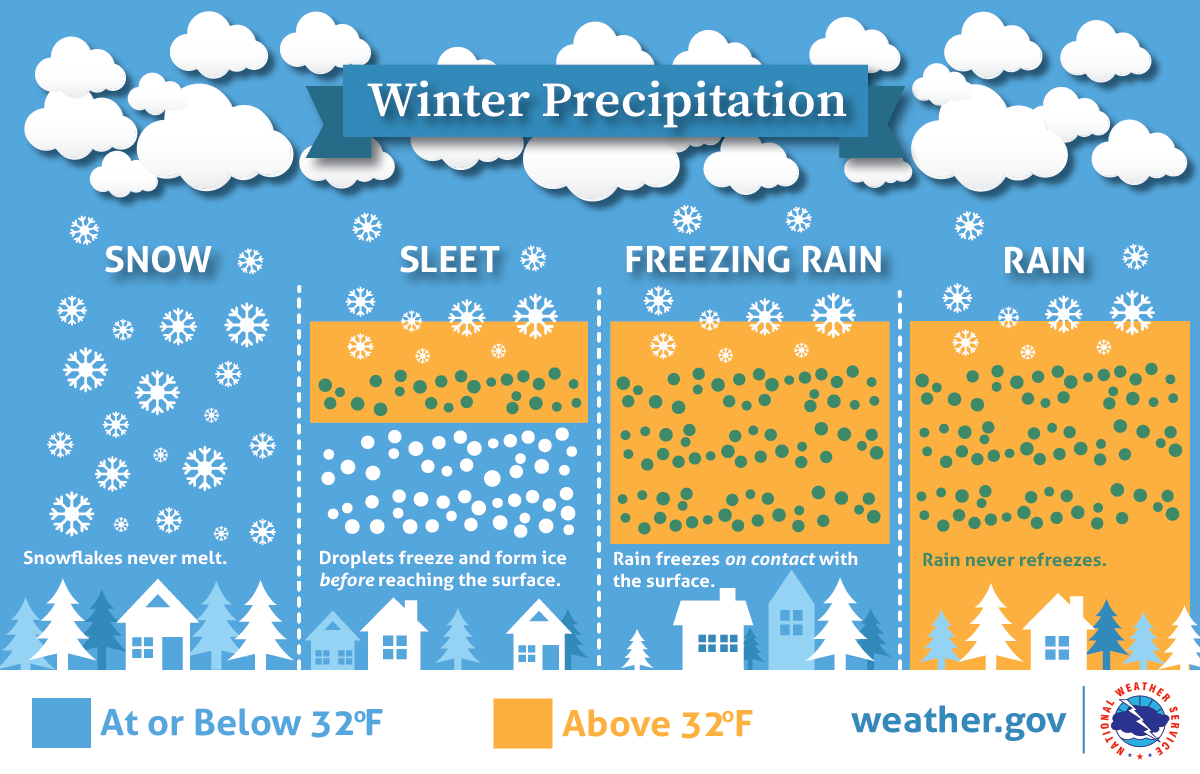 Will there be rain, ice or snow? This graphic explains how having different layers of warm and cold air between the clouds and the ground determines the type of precipitation that hits the ground. nssl.noaa.gov/education/svrwx101/winter/types/ Be prepared to receive alerts and stay updated!
For more information in between posts, please follow Pine Tree Weather on Facebook and Twitter.
Thank you for supporting this community based weather information source operates by financial contributions. Stay updated, stay on alert, and stay safe! Thank you as always for your support! - Mike |

Mike Haggett
|