
|
As I was preparing the forecast Sunday afternoon, the one song that kept going through my mind was Yakety Sax by Boots Randolph. This storm really is a Gong Show to try to figure out. It's no wonder why I have no hair on my head, which went away about 10 years ago now. As you follow along, listen to Boots and enjoy the show. Expect slick travel Tuesday Night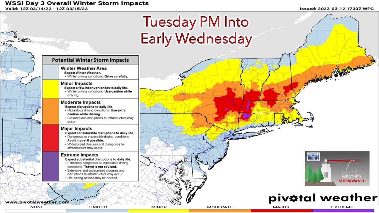 It appears at this point that the Tuesday morning commute will go off without a hitch, but conditions go downhill after that. The focus of the greatest travel impacts from the storm continues to be for the coastal plain, highlighted in orange and red. For the evening commute and for the overnight commuters, it could be tricky to dangerous, depending on what happens. Wednesday morning could be a mess as everyone digs out, and there are likely to be power outage concerns. Forecast uncertainty continues to impact outcome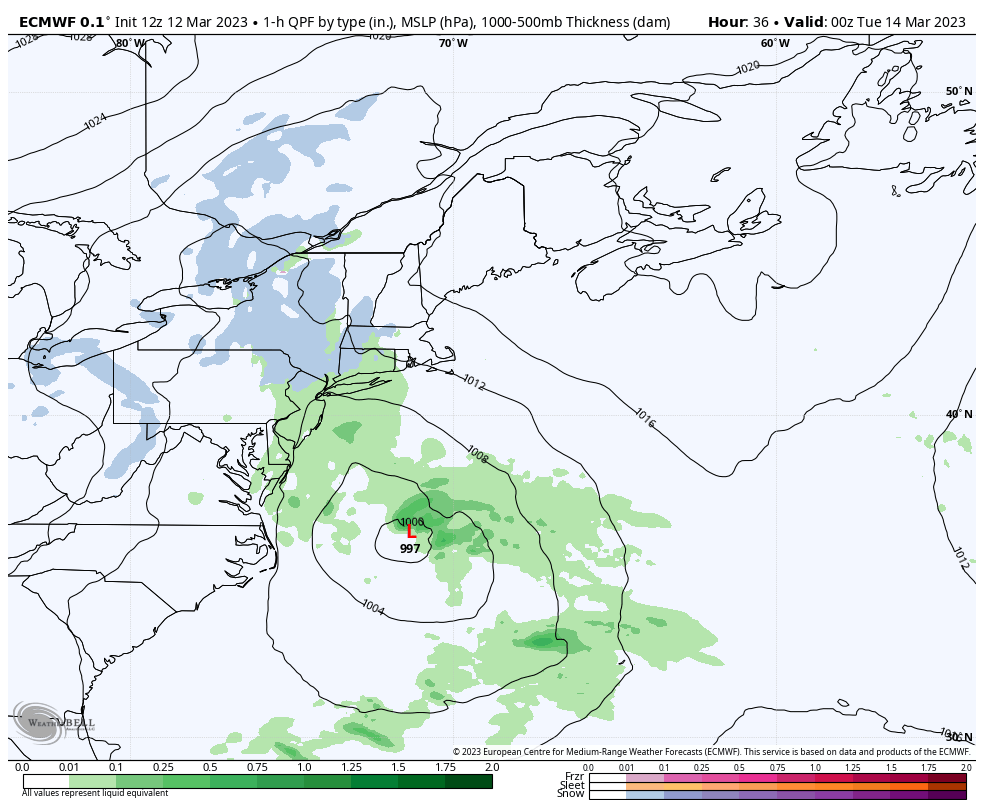 Monday 8 PM to Wednesday 11 AM - The idea for now is for the storm to crank up Monday night and boomerang to the northwest around Cape Cod and into the Gulf of Maine Tuesday afternoon as the upper-level low captures it. We could be dealing with a sub-980mb storm at that point, which means strong wind from the falling pressure along with heavy snow bands. Depending on how the pieces fall into place will determine IF the storm reaches "bombogenesis" criteria of a 30mb drop in pressure in 24-hours or not. Another wrinkle in this is the storm is dry slotting could work into this as it is coming around the horn of the Cape. As you can see, the storm could stall out east of Boston, and as it does, it begins to occlude (weaken) and spins itself out of energy and slips southeast by Wednesday morning. Three pieces in all of this I have discussed over the past couple of days is the timing of the northern stream meeting the southern stream aloft and the position and potential impacts on the outcome of high pressure to the north. 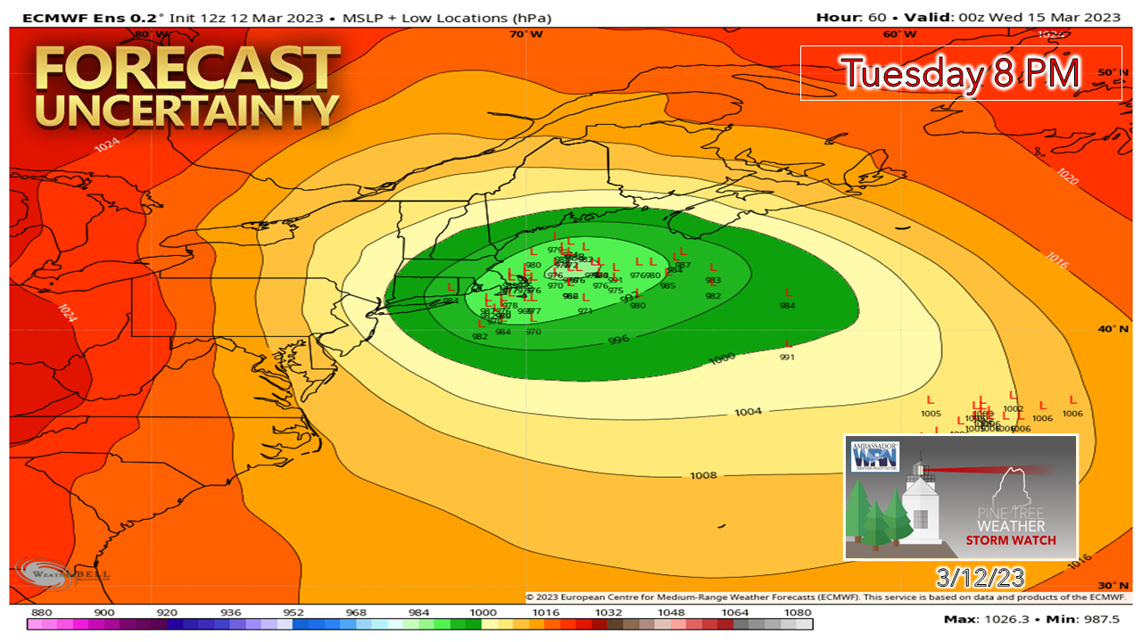 It really is absurd to have this kind of model spread on ensemble ideas 72-hours ahead of the event. The pepperoni of low-pressure ideas is still spread wide on this king pie, which means there is variance in position of the low, along with just how strong it will be. How does Boots' sax sound right about now? It's just nuts. The forecast... for now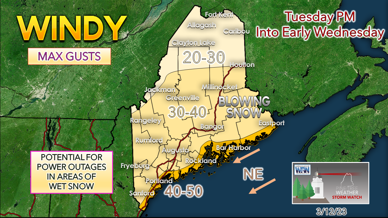 Folks along the coastal plain should anticipate potential for power loss. If the storm does the boomerang hook around the horn of the Cape and the pressure bottoms out around 975mb, the wind is going to cause problems, without question. In that case, we're talking about the potential for 100,000+ to start off dark Wednesday morning. If the storm comes in weaker, it may not be that high. Either way, it's better to be prepared than not. 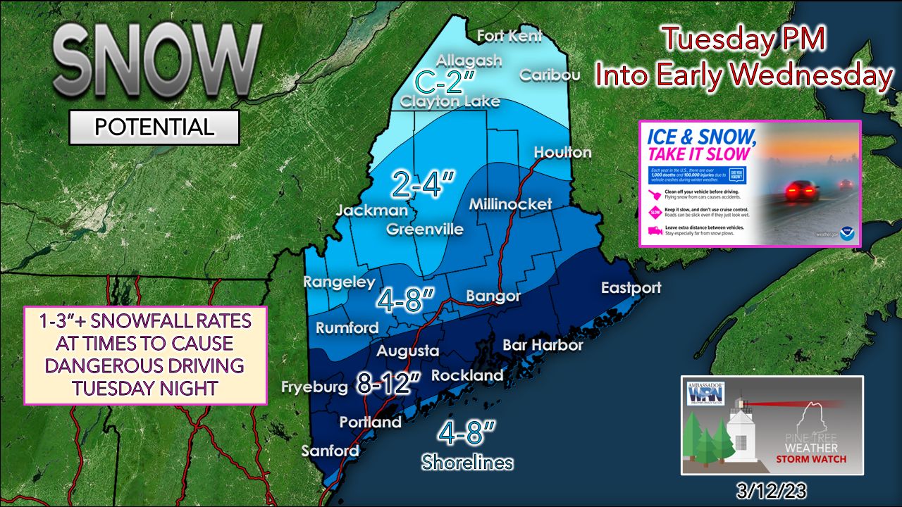 The snow to water ratios I have seen vary from model to model and hour by hour which adds even more intrigue and fingernail chewing into the outcome. In case you have not figured it out by now, there is bust potential all over the place with this storm. I can see where totals could go up due to intensity and banding. I can also see where dry slotting and a more easterly track, along with compaction, could cut totals down. The liquid equivalent idea here ranges from ½-1" over the coastal plain, ¼-½" for the foothills on up into southern Aroostook, and lesser amounts north of that. The closer to the coast, the wetter and sloppier this will be, regardless of what scenario actually plays out. 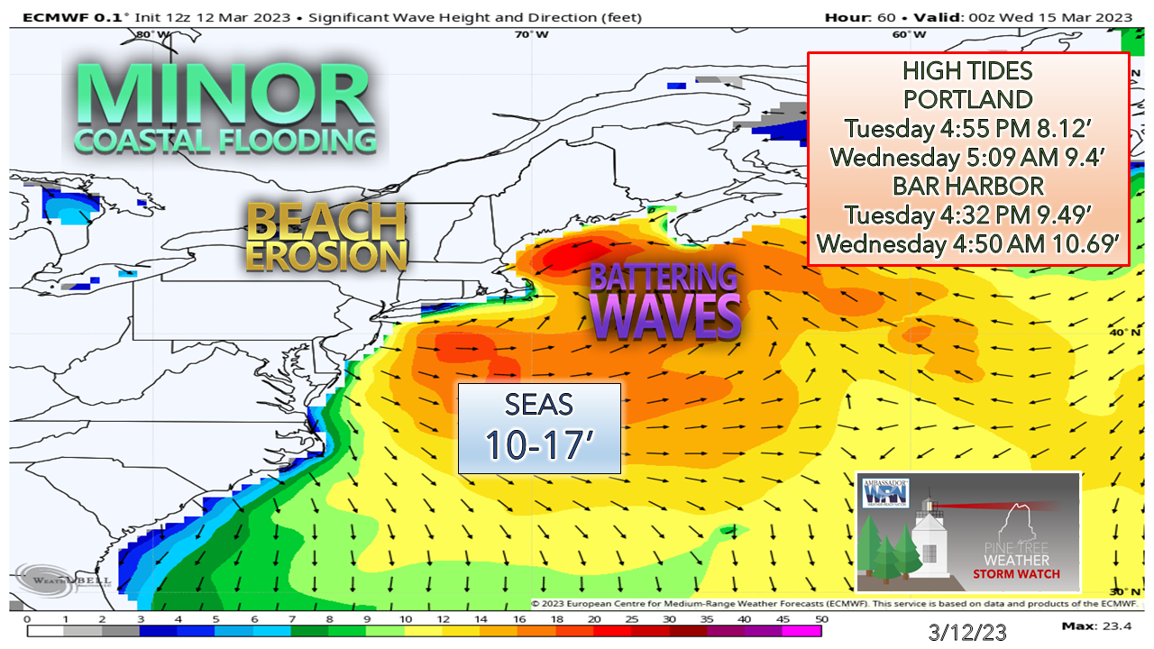 The shorelines are going to take a bit of a beating Tuesday into Wednesday. Thankfully, the high tide Tuesday afternoon is on the low end. The highest surf and potential for some storm surge comes Tuesday night, and the low water level negates too many issues there. There could be some splash-over in the usual areas with both tides, but overall, the coast escapes without any major impacts. Stay tuned for updates! Thank you as always for your support! Pine Tree Weather is funded from followers like you. I would appreciate your financial support. Click here for how you can contribute. You may not like the weather, but I hope you like what I do! Please hit the like button on Twitter and Facebook, and share! Stay updated, stay on alert, and stay safe! - Mike NOTE: The forecast information depicted on this platform is for general information purposes only for the public and is not designed or intended for commercial use. For those seeking pinpoint weather information for business operations, you should use a private sector source. For information about where to find commercial forecasters to assist your business, please message me and I will be happy to help you. |

Mike Haggett
|


