
Turning the corner With all due credit to Pastor Paul Gant of Sea Road Christian Church, "the fastest 90 days in Maine" is heading down the home stretch. Labor Day will be here in about a month. August makes the last full month of meteorological summer. It was a hot July, without question. Thankfully not as humid as last summer, but with a few uncomfortable days for sure. The big shift I have seen in comparing the past two July's is that in the rain department. July of 2018 was a wet one. July of 2019 will go in the books as one of our drier ones, with the exception of eastern areas. River and lake levels low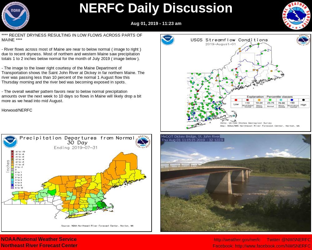 I am hearing from you folks ... it's getting dry again. After a period of wet conditions from July through June, for much of the region, it's like the faucet was shut off. Hit or miss showers and storms have brought in a bit of moisture at times, but for most of the state, concerns for drought are creeping in again. 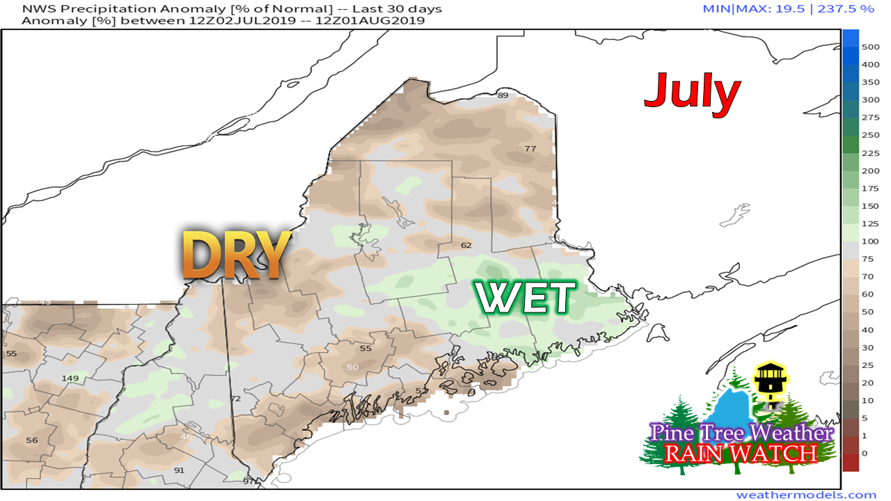 I am sure my followers in DownEast areas have had enough rain at this point, and would like at least some of the summer the rest of the state has enjoyed. It appears that when the slow moving cold fronts moved offshore, low pressure would form along it, bringing rain to the east and varying clouds elsewhere. For my friends along the Washington County shorelines and Bangor area, your time appears to have come for some dry days ahead. Above normal temperatures possible for August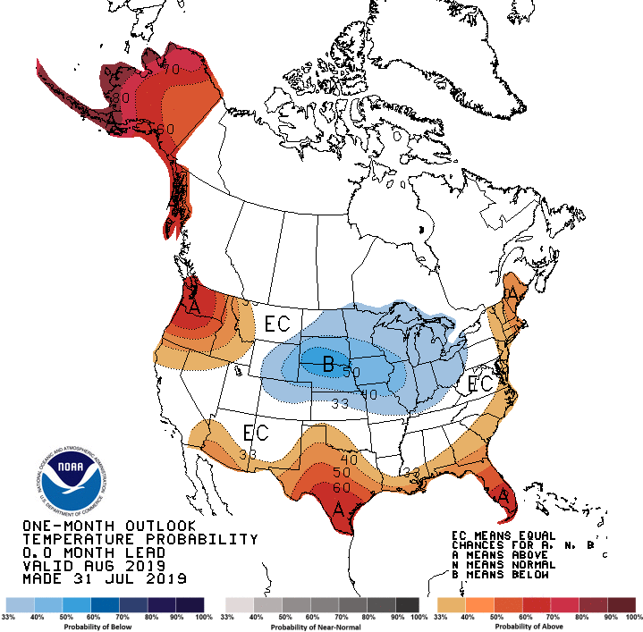 For those looking at this map and think of an omega set up, give yourself a few claps. This idea has not varied a whole lot since mid-July. While I don't expect a blast furnace for weeks, I do expect warmer than normal temperatures at times. I suspect we'll see a similar pattern that we've had for months... a couple days of warm air, weak cold fronts bringing a few light showers / storms, a cool down for a day or two, and repeat the process again. The one key ingredient that is keeping the region out of frialator long term is the absence of the Bermuda High. It comes and goes, but it does not stay parked offshore for very long. 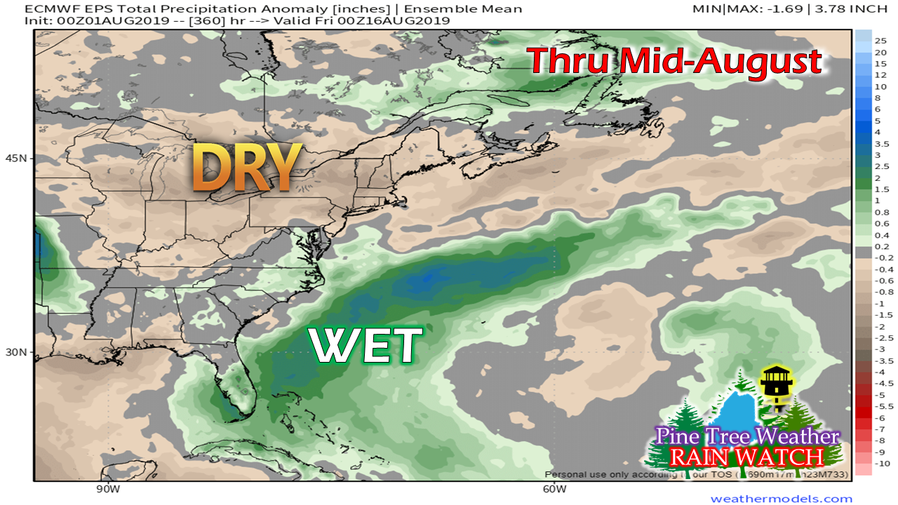 It's almost as if the Bermuda High has shifted east. Bermuda Highs typically bring humidity and moisture to the region, which can make conditions rather damp. Sure, we've had humid periods, but thinking last year we had 40 days of 70°+ dew points in areas, this summer so far has not come close to that. For now, the pattern does not support prolonged sizzling days, but it will be humid at times over the next few weeks. Synopsis outlook through the weekend Areas of valley fog are possible Friday morning as cooler, drier air starts the day. Any ground stratus burns off by roughly mid-morning and bring mainly sunny skies statewide. A sea breeze will form along the coast, cooling temperatures in the afternoon. A weak cold front passes through the region Saturday, which may touch off showers and perhaps a thunderstorm over the mountains and northern areas. I can't rule out a shower or storm for southern and eastern areas, but it would be isolated if to happen. Sunday and Monday appear pleasant. The humidity begins to build on Tuesday, with showers and thunderstorms possible Wednesday and Thursday. Off for the weekendI will do an update Friday on Facebook before I head out of town for the weekend. My next update will be on Tuesday, if not here, check the Facebook page for that as well.
► ► For the latest official forecasts, bulletins and advisories, please check in with the National Weather Service in Gray for western and southern areas, or Caribou for northern and eastern parts of Maine. Please consider supporting Pine Tree Weather ► ► Your financial donations are much appreciated to keep this site funded and for further development. FUNDRAISING FOR 2020 BEGINS SOON! I sincerely appreciate your support not only financially, but also in sharing my efforts with others. For more information from me, please check the Pine Tree Weather Facebook page as well as my Twitter feed. Always stay weather aware! - Mike |

Mike Haggett
|


