Many impacts to watch out for through late week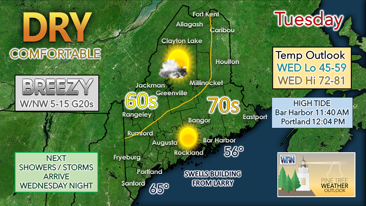 IMPACTS: For Tuesday, minimal. Potential for patchy fog around rivers, lakes and ocean areas to start Wednesday, which could be locally dense. Heavy rain and thunderstorms with localized flash flooding are possible Wednesday night through Thursday night, with the main concern for the mountains, north and eastern areas. There is a chance for isolated severe storms with a damaging wind threat for interior and eastern areas in the wee hours of Thursday into Friday, including the nighttime hours. Ocean swells from Larry increase toward the weekend, setting up likelihood of high surf, splash-over and minor flooding from astronomical high tides, along with some beach erosion and high rip currents Friday into Saturday. DISCUSSION: High pressure works into the region for Tuesday and brings breezy, dry, and comfortable conditions to the state. Coastal areas see the most sun, with fair weather clouds dotting the sky over the interior. The breezy conditions from the west/northwest wind keeps the mountains and north on the cool side, with warmer conditions for southern areas. A warm front sneaks into the region Tuesday night. With the uptick in humidity, patchy fog, locally dense is possible around areas of water to start Wednesday. Clouds increase with a cold front on approach, along with a southerly wind flow out ahead of it. Showers and storms appear to hold off through most of the daylight hours for western areas, but the Rangeley Lakes region may get an isolated shower before dark. The cold front continues its advancement Wednesday night into Thursday. The wrinkle in this is the possibility of low pressure forming along the frontal boundary on its approach into Maine. Guidance ideas indicate the potential for a long overdue soaking rainfall for the mountains and north where drought impacts are severe. A fair bet for 1"+ of rainfall with locally higher amounts from thunderstorms are possible in the higher elevations. Potential for training of storms could double or triple the amount of rainfall (2-3"+) and set up potential for localized flash flooding. Pending on the development of low pressure and position along the front dictates rain amounts for the coastal plain. Southern areas may escape with under 1", but potential exists for 1-1½" for MidCoast and eastern areas through Friday morning, with locally higher amounts possible from thunderstorms Thursday night into Friday. The cold front is on track to depart the region Friday with improvement in conditions from west to east during the day. Showers and storms end over eastern areas by roughly early afternoon. An upper-level trough drops into the region for Friday, which keeps Hurricane Larry well to the east. Seas could build in the 7-10' range for exposed areas along the coast. Along with elevated high tides from the new moon this week, the shorelines could take a bit of a beating with the high surf, splash-over, beach erosion and minor flooding through Friday night. The increase of wave heights raises the rip current risk through the rest of the week into Saturday. As Larry clips Newfoundland on its way into the north Atlantic Friday night, seas gradually calm into the weekend. Saturday appears fair for the region as high pressure controls the day. Sunday sees another slow-moving cold front on approach which could bring showers to north and mountains during the day, and rain for southern and eastern areas Sunday night into Monday. Expect this part of the forecast to be fine-tuned for timing and rain amounts. A lot going on with many moving parts, so it is wise to stay updated on the forecast for any changes.  Camping safety Going camping? Watch out for thunderstorms! Know your weather forecast and notify your family or friends of your plans. Have an evacuation plan and know where you can find shelter. Make sure to pack a safety kit and a radio for forecast updates. weather.gov/safety/thunderstorm Be prepared to receive alerts and stay updated!
For more information in between posts, please follow Pine Tree Weather on Facebook and Twitter.
Thank you for supporting this community-based weather information source which operates by reader supported financial contributions. Stay updated, stay on alert, and stay safe! - Mike |

Mike Haggett
|