
Just enough of an ice threat to be concerned with travelWhile precipitation may start a bit later than originally forecast, the threat for freezing rain and sleet remains the main concern for Monday. Once the first low departs Monday night, a second low tracks in which will deliver snow to the interior areas of the state Tuesday. For those commuting around the region, it's important to remain guarded for changing road conditions. 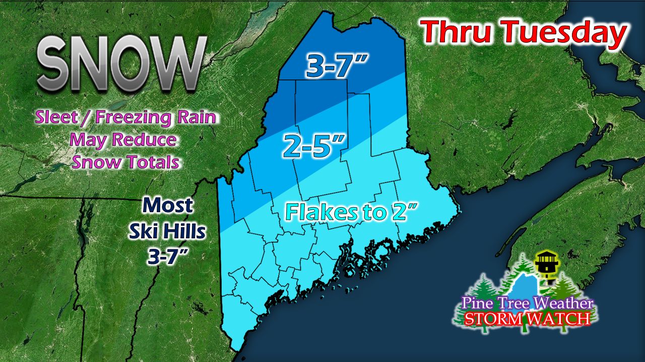 Interior areas will see the most snow, with the rooftop of the state likely to get the higher amounts. Higher elevations in the western mountains over to the central highlands and the Baxter State Park region end up in the 3-7" range. South of that area, southwest coastal areas may see some flakes, with the best chance of any accumulating snow occuring away from the shoreline, and it appears nominal at that. WInter Weather Advisories are posted for the concern for ice rather than snow across the coastal plain on up into the foothills and southern Aroostook. If you read my post here Sunday evening, I discussed cold air damming and how that could throw a wrench into the forecast, and it still is. With single digits above and below zero to start off Monday in the north, along with three days of record cold, rest assured that if precipitation makes the surface in liquid form, it will freeze and could do so on contact. I do not expect any widespread power outage problems from ice accretion. I do expect slick roads, sidewalks, paths and parking lots. I do expect enough rain or drizzle to freeze to windshields for a good portion of the region. 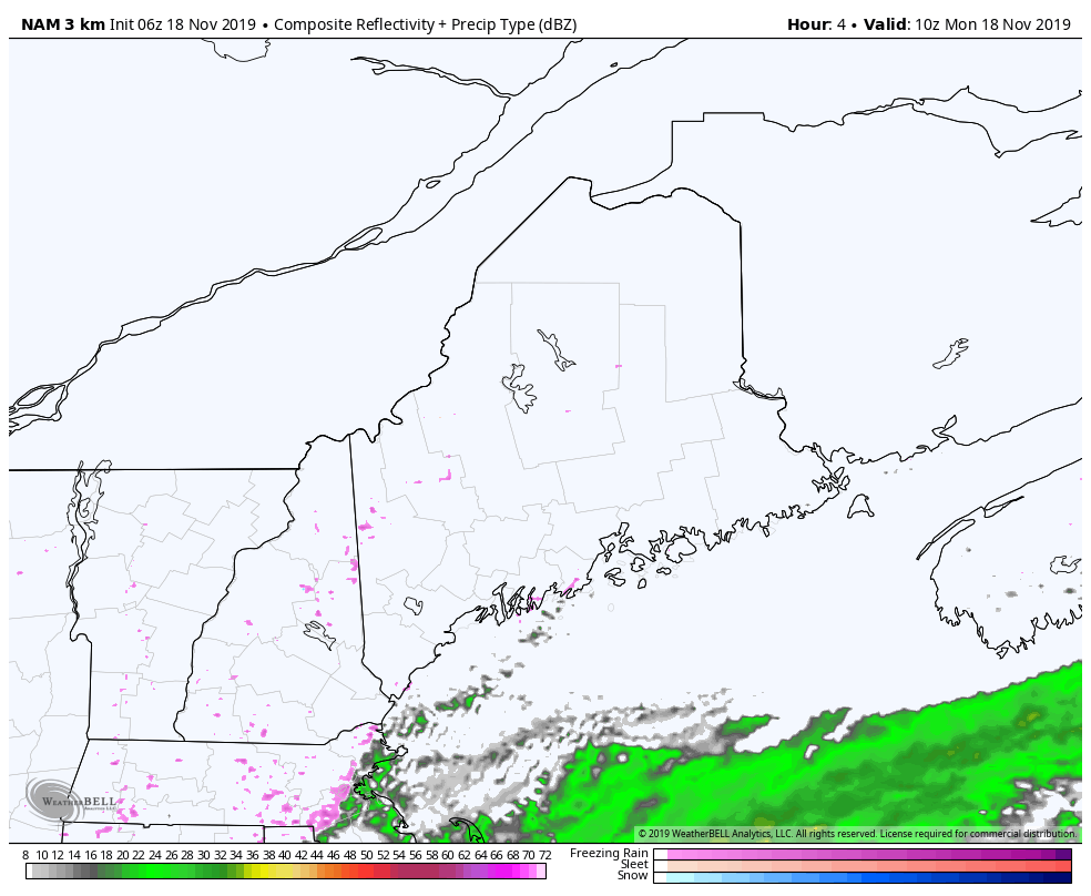 Timing shows impacts for the coastal areas Monday morning, pushing northwest and reaching the western mountains in the afternoon, and northern areas by evening. How long the icing goes on depends fully on how long it takes for warm air to overtake the cold at the surface, and that may take awhile, if it happens at all. I suspect that not only warm air will intrude at the upper level, cold air may sneak in also, which if that is the case, that is where sleet will be a factor. After the first low begins to exit the region Tuesday morning, a secondary low will come through on its heels. There may be a bit of a lull over the interior in between the two lows, but it won't last long, Precipitation ends from southwest to northeast Tuesday afternoon into early evening, with the last of the snow departing northern areas between 6-8 PM. 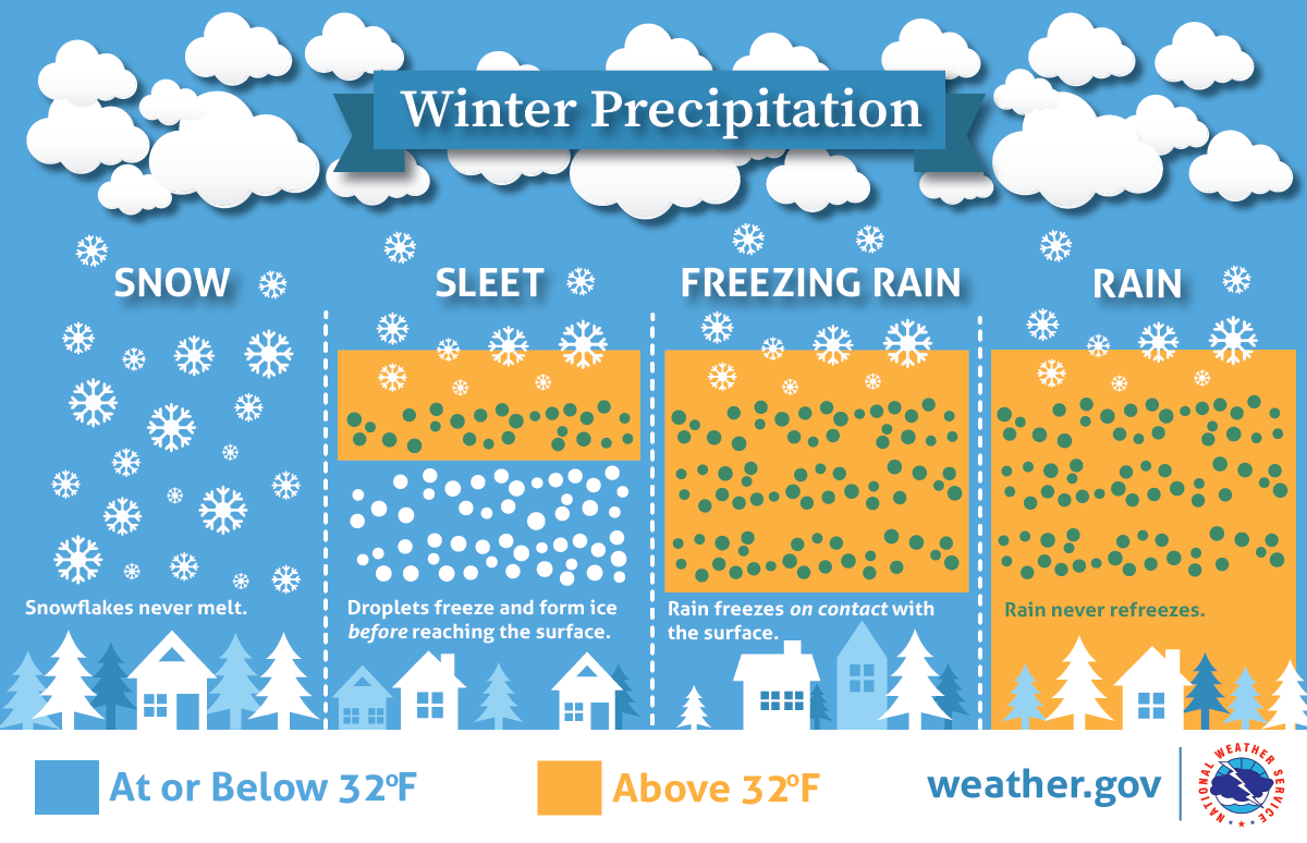 Remember to TAKE 5° OFF YOUR VEHICLE THERMOMETER to get a better read on what the surface temperature may be. This is one of those annoying storms where precipitation is just enough to cause minor issues, but so long as it is driven with the conditions, this is not a big deal. Allow for extra time, expect rapidly changing road conditions, and expect cold air to do its thing here and be stubborn. ► ► For the latest official forecasts, bulletins and advisories, please check in with the National Weather Service in Gray for western and southern areas, or Caribou for northern and eastern parts of Maine. Your help is needed to keep this website going! ► ► DONATION DRIVE UPDATE - $640 shortfall for the year ahead! You can help keep Pine Tree Weather going with a donation of any amount now through VENMO @PineTreeWeather, a monthly donation on Patreon or messaging me on Facebook or Twitter to send a check in the mail. Thank you for your support!
For more information from me, please check the Pine Tree Weather Facebook page as well as my Twitter feed. Always stay weather aware! - Mike |

Mike Haggett
|


