Pine Tree Weather
  • DISCUSSIONS
  • DONATE
  • WEATHER WALL
  • MAPS
  • RAIN OUTLOOK
  • SEVERE
  • MARINE
  • CPC OUTLOOK
  • Kennebunk
  • MY BIO
  • PTW IN MEDIA
  • OBSERVING WEATHER
  • INTERNSHIPS
  • INTERN ALUMNI
  • DISCUSSIONS
  • DONATE
  • WEATHER WALL
  • MAPS
  • RAIN OUTLOOK
  • SEVERE
  • MARINE
  • CPC OUTLOOK
  • Kennebunk
  • MY BIO
  • PTW IN MEDIA
  • OBSERVING WEATHER
  • INTERNSHIPS
  • INTERN ALUMNI

Quick hitting storm passes through Maine Saturday; multi-day event to start the week

1/2/2021

Comments

 
Picture

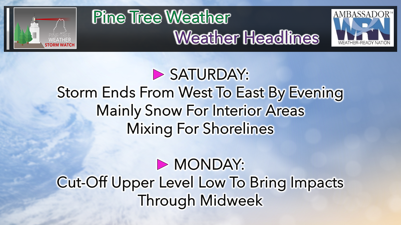
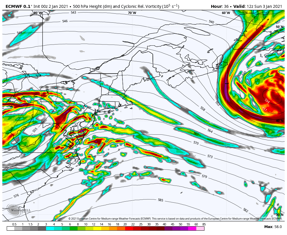
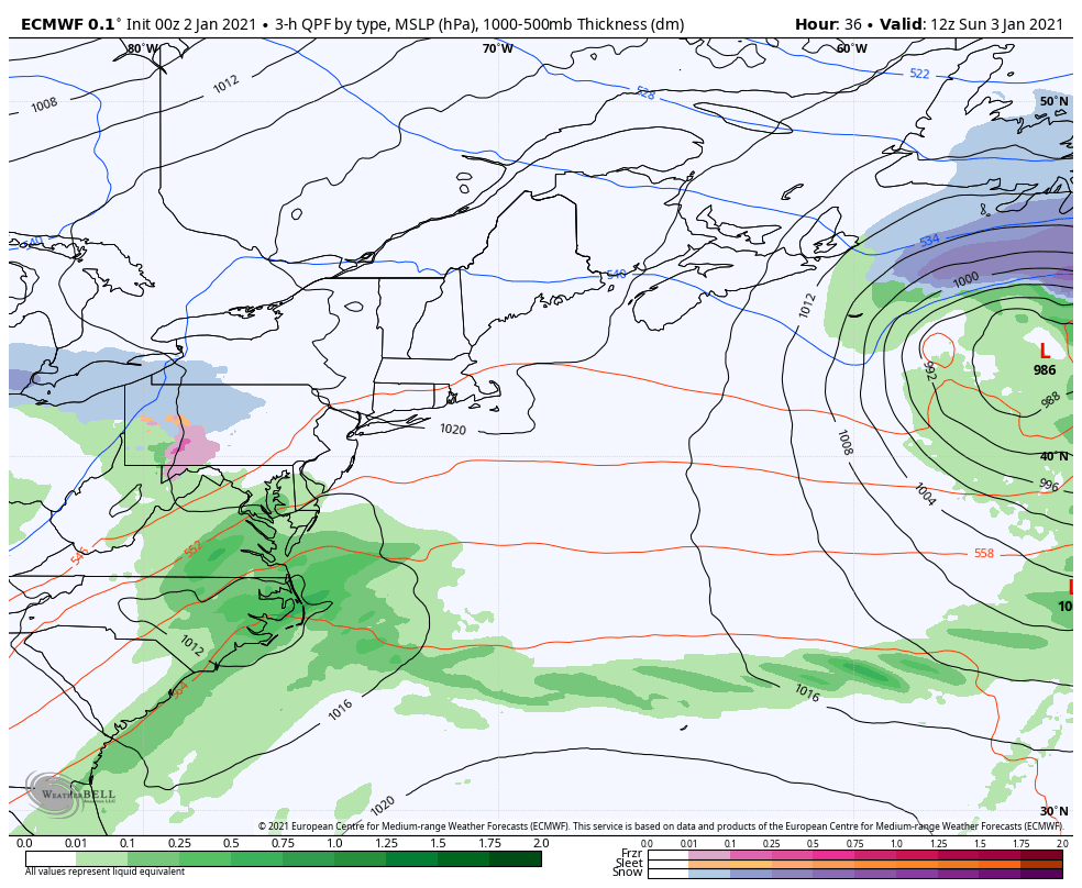
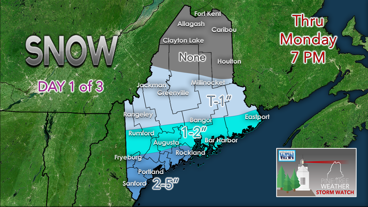
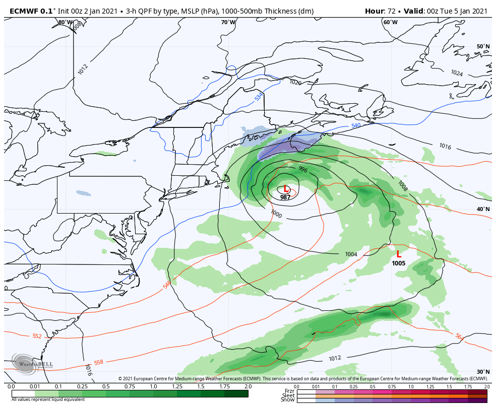
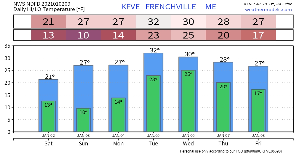
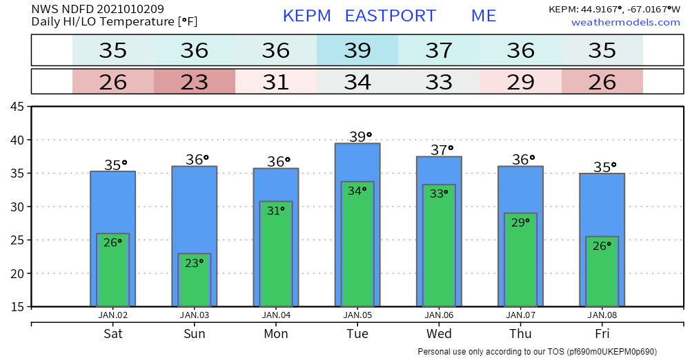
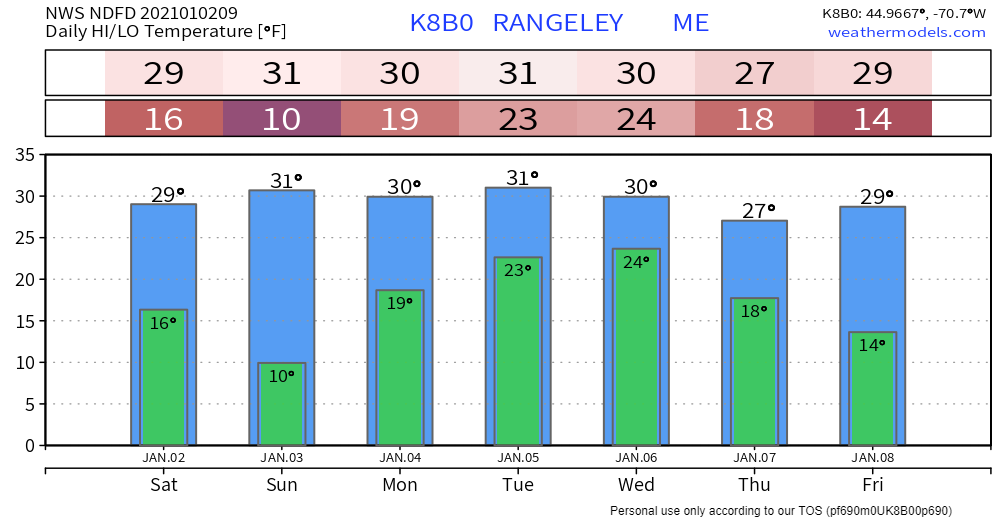
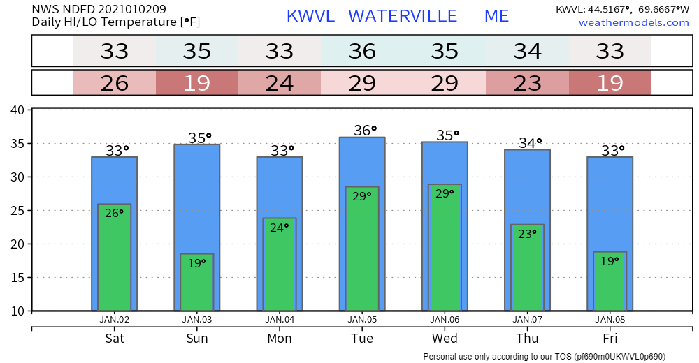
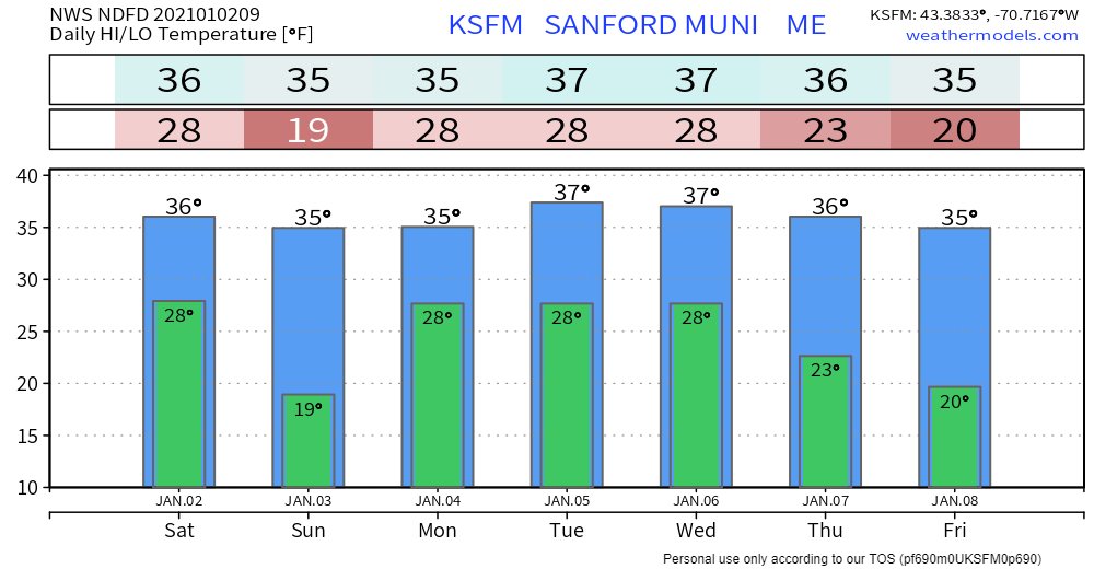
Banding to dictate snow amounts Saturday

Picture
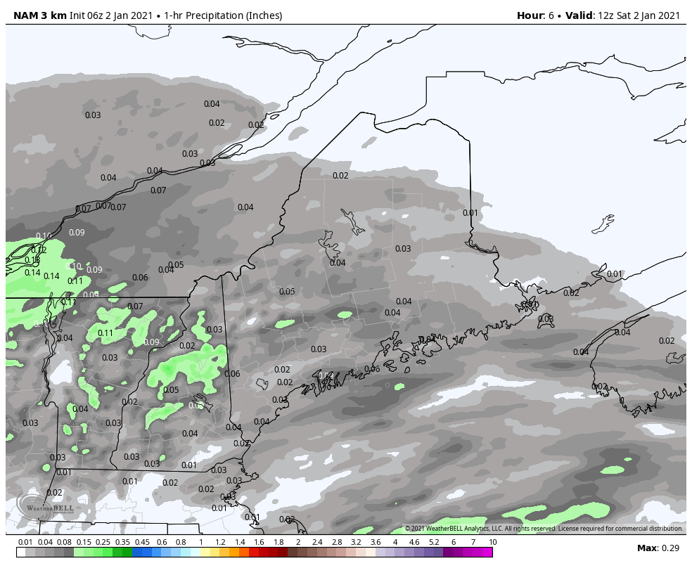
Using hourly liquid equivalent projected rain totals to enhance the idea of banding potential. While I do not expect any widespread 1"/hour snowfall rates, it may happen in isolated areas. The storm ends from west to east this afternoon, and by 7 PM will be clear of the state, outside of any snow showers in the mountains. 
Picture
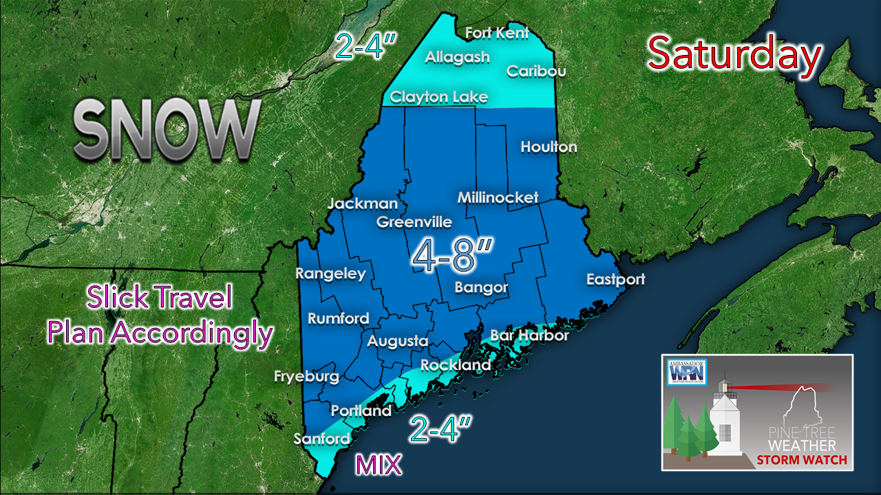
No changes to my forecast idea for snow totals posted here on Friday. Higher elevations may see as much as 10", some banding may deliver around the same amount as well. For most of the state, this is a 4-8" event, with lesser amounts along the southwest coast and north. 

As the storm moves east, a northwesterly wind picks up and gusts to around 25 mph in places and will diminish overnight into Sunday morning.

The sky clears out overnight, and brings a sunny start to Sunday. Clouds will be on the increase Sunday afternoon ahead of the storm on the way Monday.

Cut-off upper level low to hang around
​through midweek

Picture
I am going to get right out in front of this and say that cut off upper level lows have a mind of their own and as a result, the confidence in forecast is low. This European model idea of vorticity and heights at 500mb (altimeter ~18,230 feet) shows the energy generated from temperature variables and how spread out and slow moving it is. This loop runs from 7 AM Sunday to 7 PM Thursday. It shows the wobbles and injections of energy at the mid-level, all of which plays out on what happens at the surface, to a certain degree. Notice how one pocket of energy backs in to Maine Tuesday into early Wednesday... this is the type of set up where confidence is low, so the best course of processing is to take it a day at a time and see how this plays out. 
Picture
Focusing here from 7 AM Sunday to 7 PM Monday shows the ejection of the surface low off the DelMarVa peninsula and a northeast track close to benchmark 40°N / 70°W south of Nantucket. Coastal areas of Maine see the snow in this case. Folks in southwestern areas can expect a slick commute to work Monday morning. How far north the snow gets depends on the surface high and the ridge to the north.  
Picture
For now, I do not expect much in the way of snowfall for the northern half of the state.

Banding and the position of the surface low will dictate what happens. Any deviations to the north/northwest (more precipitation) or south/southeast (less precipitation) will have impacts on the outcome given region is on the fringe of the storm.
Picture
From 7 PM Monday to 7 PM Wednesday, there is potential for the surface low to back in on the region. DownEast and central areas could get roughly a foot of snow out of this. Southwestern areas could see a similar outcome pending on the track, also. At the time of this update Saturday morning, it is too early to tell what will happen beyond Monday. 

Alex will have a full update on this here at some point Sunday morning. 

Picture

​Winter Injuries and Fatalities

Picture
Slippery sidewalks and roads aren’t the only things to look out for in late winter and early spring snow storms. Shoveling snow can be a health risk as well. Remember to stay hydrated, take frequent breaks, and move only small amounts with each shovel pass. Learn more at weather.gov/winter

Temperature outlook through Friday

Temperatures continue to run above normal overall. I continue to wave the flag of caution that highs and lows may be a bit cooler pending on how the cut-off upper low and associated surface low scenario plays out. 
Picture
Picture
Picture
Picture
Picture

Be prepared to receive alerts and stay updated!

Picture
​​BE PREPARED WITH A NOAA Weather Radio.

​For $20-$40, it could provide important information to you when you need it. The weather bands are standard on most public safety scanners, and newer scanner models. Weather radios can be programmed for auto alert.  Click here for more information.

​► ► For the latest official forecasts, bulletins and advisories, please check in with the National Weather Service in Gray for western and southern areas, or Caribou for northern and eastern parts of Maine
Picture

For more information, please follow Pine Tree Weather on Facebook and Twitter. 

** FUNDING NEEDED FOR 2021 **
​Thank you for supporting this community based weather information source that is funded by your financial contributions. 


Stay updated, stay on alert, and stay safe!

​- Mike
Comments
    Picture

    Mike Haggett
    Kennebunk, ME

    Weather-Ready Nation
    Ambassador

    Certified Weather
    Forecaster
    Penn State '21

    American Meteorological Society

    National Weather Association
    ​
    ​SKYWARN-CWOP

    Matthew 19:26


    DONATE

    Picture
    Picture
    Picture
    Picture
    Picture

    Picture

    Picture

    Picture

    Picture

    Picture

    Picture

    Picture

    Picture

    Picture

    Picture

    Picture

    Picture


    Archives

    April 2025
    March 2025
    February 2025
    January 2025
    December 2024
    November 2024
    October 2024
    September 2024
    August 2024
    July 2024
    June 2024
    May 2024
    April 2024
    March 2024
    February 2024
    January 2024
    December 2023
    November 2023
    October 2023
    September 2023
    August 2023
    July 2023
    June 2023
    May 2023
    April 2023
    March 2023
    February 2023
    January 2023
    December 2022
    November 2022
    October 2022
    September 2022
    August 2022
    July 2022
    June 2022
    May 2022
    April 2022
    March 2022
    February 2022
    January 2022
    December 2021
    November 2021
    October 2021
    September 2021
    August 2021
    July 2021
    June 2021
    May 2021
    April 2021
    March 2021
    February 2021
    January 2021
    December 2020
    November 2020
    October 2020
    September 2020
    August 2020
    July 2020
    June 2020
    May 2020
    April 2020
    March 2020
    February 2020
    January 2020
    December 2019
    November 2019
    October 2019
    September 2019
    August 2019
    July 2019
    June 2019
    May 2019
    April 2019
    March 2019
    February 2019
    January 2019
    December 2018
    November 2018
    October 2018
    September 2018
    August 2018
    July 2018
    June 2018
    May 2018
    April 2018
    March 2018
    February 2018
    January 2018
    December 2017
    November 2017
    October 2017

Proudly powered by Weebly