Sunshine and lower humidity returns Thursday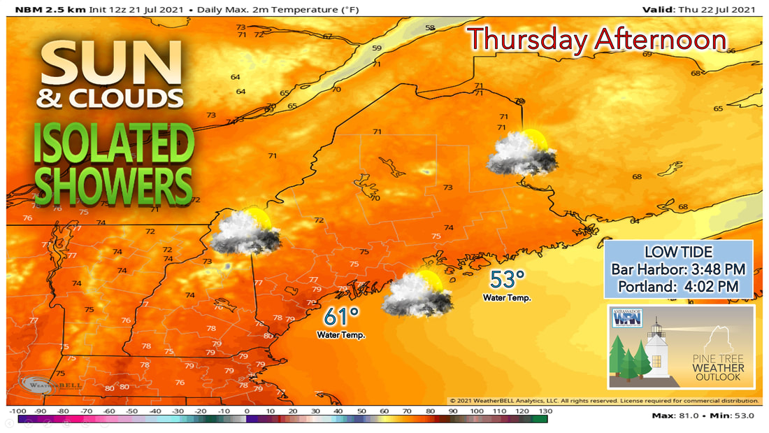 Sun and clouds with a chance for isolated showers is likely Thursday. Friday looks to be a drier day with clouds lingering thanks to a low-pressure system to our east. Saturday looks to be the pick of the weekend with more sunshine than clouds. A return to the sunshine is in store for the day on Thursday. An area of high pressure will likely slowly make its way to the east during the daytime Thursday. Meanwhile, the low-pressure system that brought showers and storms to the area on Wednesday likely continues to sit close enough to the state to spin clouds and popup showers into the region during the day Thursday. Showers will likely be hit or miss for most places, with the majority of the activity looking to happen the further east in the state you go. Western parts of the state are likely to see more sunshine during the day Thursday. High temperatures Thursday will likely make it into the lower and mid 70s for most of the state, with southern areas, mainly York and Cumberland counties seeing highs making it into the mid to upper 70s. 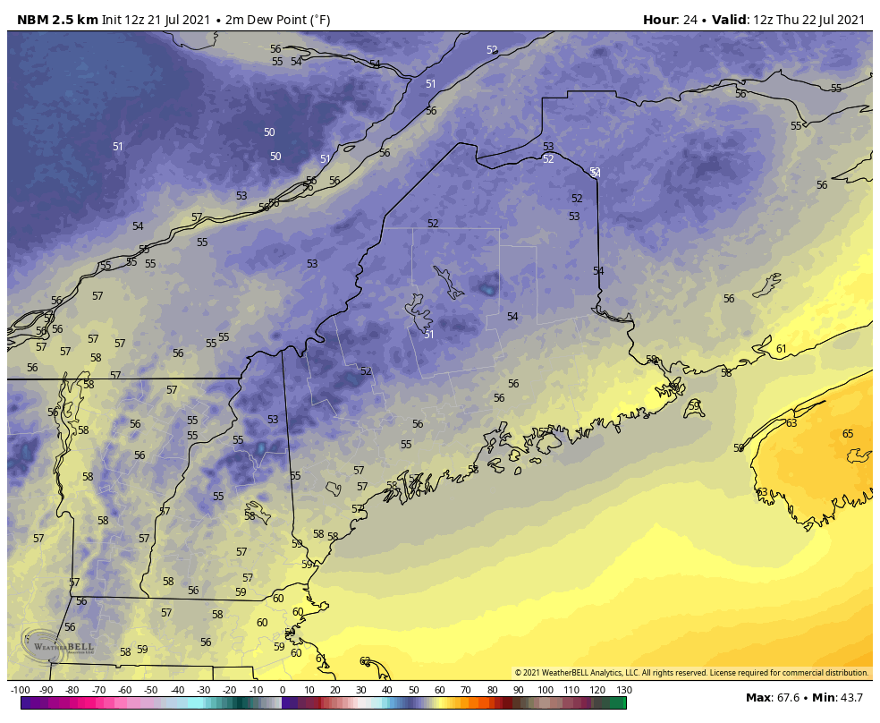 The biggest change people will likely notice tomorrow is the decrease in humidity. Once the cold front clears the coast Wednesday night, it will take the humidity and the smoke that we've seen over the past few days with it. Dewpoints waking up Thursday morning will likely be in the lower to mid 50s and will likely continue to drop heading throughout the day on Thursday thanks to the northwesterly wind we'll likely see. This likely continues through the overnight hours Thursday into Friday, so expect the relief from the humidity to continue through the end of the work week. Clouds hang around for Friday, slightly warmer temperatures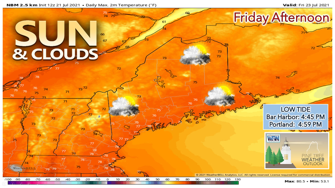 Friday looks to be a nicer day, with the chances of rain diminishing as the as the surface low continues to push off to our east, and high pressure continues to build in from the west. A mixture of sun and clouds is likely once again for the daytime Friday, The best chance of seeing more sunshine will likely be during the morning hours on Friday, as clouds look to become more scattered by the afternoon hours on Friday. 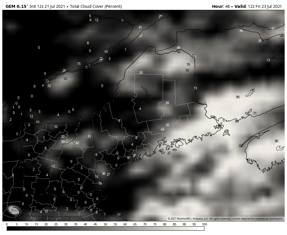 High temperatures on Friday will once again be on the warm side, but nothing incredibly hot as most of the state climbs up into the mid 70s. York and Cumberland counties once again likely have a better chance of seeing temperatures make it into the upper 70s, with more sunshine expected the further west you head once again Friday. Nice start to the weekend, humidity and rain builds in by Sunday Saturday appears to be the best of the two weekend days at the moment. High pressure will likely continue to build overhead during the day on Saturday, before sliding to the east during the afternoon. This likely allows for winds to shift into the southwest during the afternoon on Saturday, resulting in warmer temperatures across the state. High temperatures on Saturday likely make into the upper 70s for a majority of the state, with a few communities getting close to 80 degrees. Sunday, a warm front begins to move through the state during the morning hours, which results in more rain during the day on Sunday. High temperatures are likely kept back a few degrees from where they were Saturday thanks to the cloud cover and rain.  The other big thing people will likely notice is the return of the humidity by the time we get into Sunday. Most places across the state will likely see dewpoints climb back into the upper 60s heading into Sunday afternoon. With the return of the humidity will likely bring smoke from the wildfires out in the western U.S. back into our region over the beginning of the work week, as the humid air mass looks likely to stay around through at least the middle of next week. Temperatures during this time won't be incredibly warm, but with the higher humidity temperatures in the upper 70s and lower 80s will definitely feel warmer over this stretch. Understanding Severe Weather Outlooks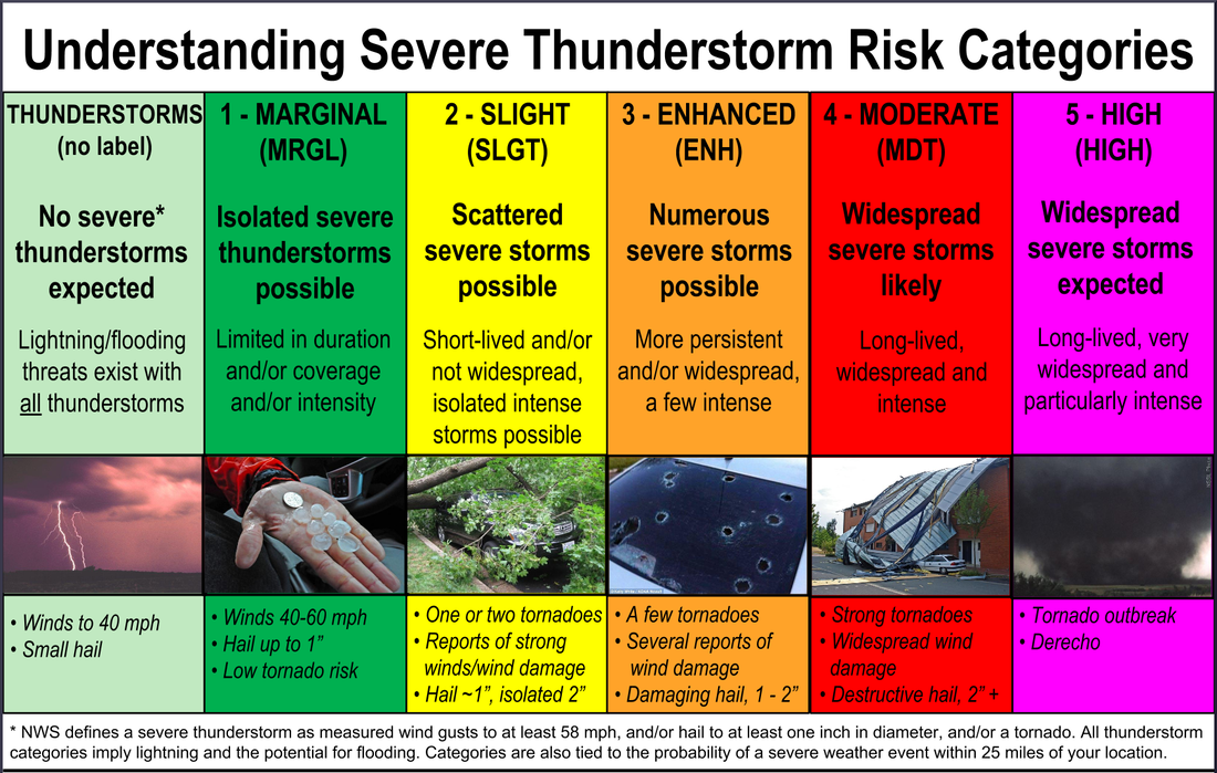 Do you know the risk categories for severe weather? Learn the severe weather outlooks issued by the Storm Prediction Center ► spc.noaa.gov Number of Severe Warned Storms Year to Date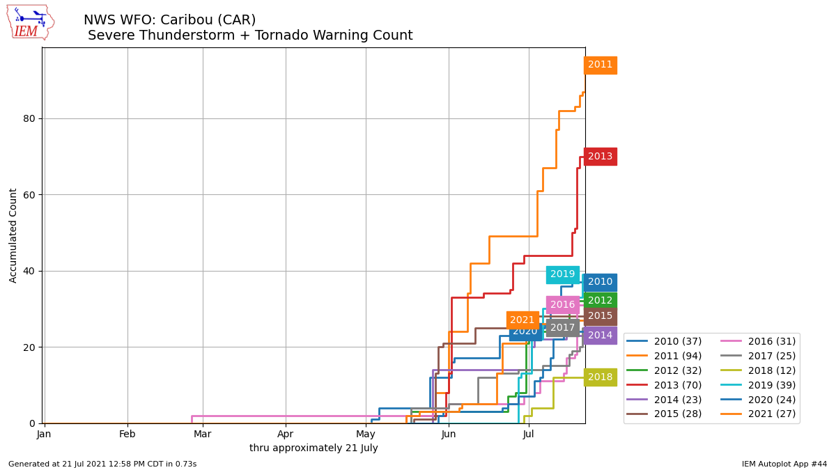 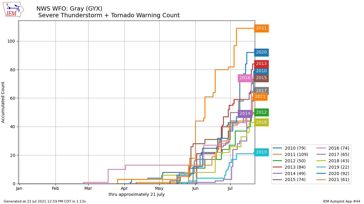 While much of the state has seen severe weather activity this season, compared to the past 10 years we've actually been about average when it comes to severe thunderstorm and tornado warnings issued by the National Weather Service forecast offices in Gray and Caribou. The big year that stands out is 2011, when both offices issued close to if not over 100 warnings by this time that season. That's compared to the 60 the NWS Gray has issued, and the 27 the NWS Caribou has issued. One thing to note, for southern and western Maine and New Hampshire, 2020 was another active year, with warnings issued by this time last year around 92. Temperature outlook through next SaturdayWhile we don't have any significant heat in the forecast, high temperatures are likely to climb closer to normal heading into early next week. The bigger story will likely be the low temperatures that remain a few degrees above average in most spots heading through early next week. While temperatures won't be as warm as they could be, dew points will likely help to make it feel warmer, as they remain high well into next week.     Be prepared to receive alerts and stay updated!
For more information in between posts, please follow Pine Tree Weather on Facebook and Twitter.
Thank you for supporting this community-based weather information source which operates by reader supported financial contributions. Stay updated, stay on alert, and stay safe! |

Mike Haggett
|