Pine Tree Weather
  • DISCUSSIONS
  • DONATE
  • WEATHER WALL
  • MAPS
  • RAIN OUTLOOK
  • SEVERE
  • MARINE
  • CPC OUTLOOK
  • Kennebunk
  • MY BIO
  • PTW IN MEDIA
  • OBSERVING WEATHER
  • INTERNSHIPS
  • INTERN ALUMNI
  • DISCUSSIONS
  • DONATE
  • WEATHER WALL
  • MAPS
  • RAIN OUTLOOK
  • SEVERE
  • MARINE
  • CPC OUTLOOK
  • Kennebunk
  • MY BIO
  • PTW IN MEDIA
  • OBSERVING WEATHER
  • INTERNSHIPS
  • INTERN ALUMNI

Rain ends from west to east Friday, unsettled weekend ahead

4/8/2022

Comments


A wet end of the week

Picture
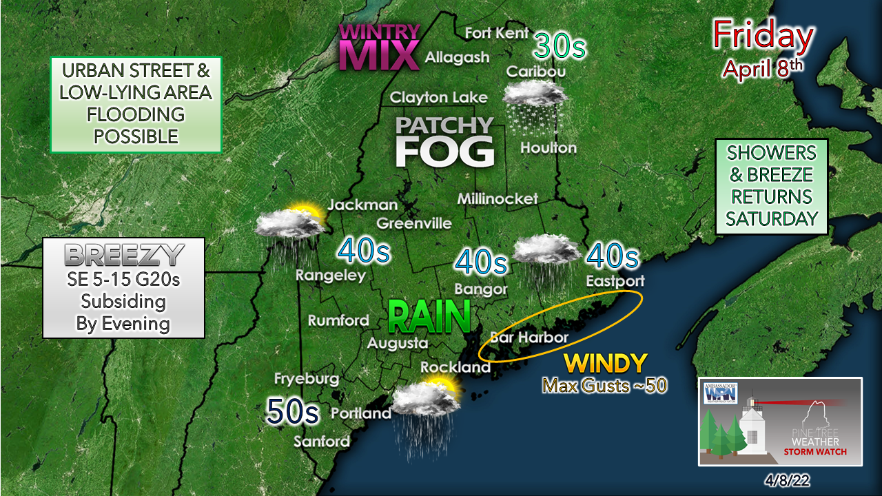
Low pressure crossing through southern New England heads tracks into the Canadian Maritimes Friday. Heavy rain and a gusty wind accompany it. A wind advisory is posted for the DownEast shorelines by the National Weather Service Caribou office where gusts could reach upwards of 50 mph through mid-afternoon.
Picture
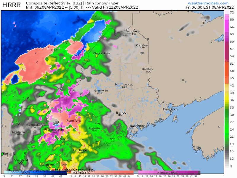
Friday 6 AM to Saturday Midnight - With the heavy rain comes the threat of gusty wind as the low-level jet reaches speeds of 65 knots (75 mph). Some spotty power outages are possible. Wind gusts around 50 mph are possible in the western mountains through the morning. As the rain tapers off, the wind begins to subside. Shoreline areas have the chance to hear a few rumbles of thunder as the rain passes through the region. Western and southern areas see the rain taper off by late morning / early afternoon and can expect sun in the afternoon. Bangor may get a sunset view late in the day.  The sky clears for most for a few hours overnight, but clouds appear to be on the increase heading into Saturday morning. Southwestern areas, the western foothills and MidCoast regions have the best chance to see 1-2" of rainfall. There is a risk for minor flooding in poor drainage areas and some urban street flooding from clogged drains.

Another round of showers & breeze for Saturday

Picture
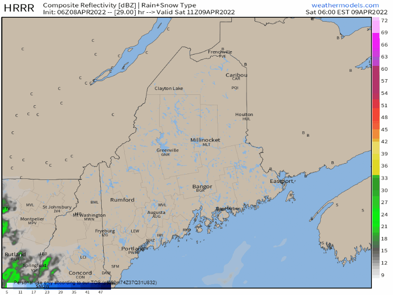
Saturday 6 AM to Sunday Midnight - An upper-level disturbance pinwheels through the region for Saturday, bringing another chance for rain showers and perhaps some wet snow for the higher elevations. through the day. A southeasterly breeze kicks up once again, with gusts reaching 30 mph along the coast and higher elevations, 15-25 mph is likely the peak for interior areas, settling in the evening. Some areas could see as much as another ½" of rainfall where the heavier showers occur.

Outlook through Wednesday

Sunday is the coolest day of the period for interior areas and brings the chance for rain/snow showers for the mountains and north, along with a northwest breeze for the rest of the area. Monday appears to be the driest day in the 5-day timeline. A chance for showers returns to the region for Tuesday and Wednesday, along with warmer temperatures. 
Picture

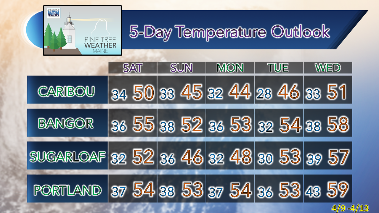
Be prepared to receive alerts and stay updated!

Picture
​BE PREPARED WITH NOAA Weather Radio.
​​
​For $20-$40, it could provide vital information to you when you need it. The weather bands are standard on most public safety scanners, and newer scanner models. Weather radios can be programmed for auto alert. Click here for more information.

► ► For the latest official forecasts, bulletins, and advisories, please check in with the National Weather Service in Gray for western and southern areas, or Caribou for northern and eastern parts of Maine.
Picture

Picture
For more information in between posts, please follow Pine Tree Weather on Facebook and Twitter. 

​Thank you for supporting this community-based weather information source which operates by reader supported financial contributions. 

Thank you as always for your support! 

- Mike

​NOTE: The forecast information depicted on this platform is for general information purposes only for the public and is not designed or intended for commercial use. For those seeking pinpoint weather information for business operations, you should use a private sector source. For information about where to find commercial forecasters to assist your business, please message me and I will be happy to help you.
Comments
    Picture

    Mike Haggett
    Kennebunk, ME

    Weather-Ready Nation
    Ambassador

    Certified Weather
    Forecaster
    Penn State '21

    American Meteorological Society

    National Weather Association
    ​
    ​SKYWARN-CWOP

    Matthew 19:26


    DONATE

    Picture
    Picture
    Picture
    Picture
    Picture

    Picture

    Picture

    Picture

    Picture

    Picture

    Picture

    Picture

    Picture

    Picture

    Picture

    Picture

    Picture


    Archives

    May 2025
    April 2025
    March 2025
    February 2025
    January 2025
    December 2024
    November 2024
    October 2024
    September 2024
    August 2024
    July 2024
    June 2024
    May 2024
    April 2024
    March 2024
    February 2024
    January 2024
    December 2023
    November 2023
    October 2023
    September 2023
    August 2023
    July 2023
    June 2023
    May 2023
    April 2023
    March 2023
    February 2023
    January 2023
    December 2022
    November 2022
    October 2022
    September 2022
    August 2022
    July 2022
    June 2022
    May 2022
    April 2022
    March 2022
    February 2022
    January 2022
    December 2021
    November 2021
    October 2021
    September 2021
    August 2021
    July 2021
    June 2021
    May 2021
    April 2021
    March 2021
    February 2021
    January 2021
    December 2020
    November 2020
    October 2020
    September 2020
    August 2020
    July 2020
    June 2020
    May 2020
    April 2020
    March 2020
    February 2020
    January 2020
    December 2019
    November 2019
    October 2019
    September 2019
    August 2019
    July 2019
    June 2019
    May 2019
    April 2019
    March 2019
    February 2019
    January 2019
    December 2018
    November 2018
    October 2018
    September 2018
    August 2018
    July 2018
    June 2018
    May 2018
    April 2018
    March 2018
    February 2018
    January 2018
    December 2017
    November 2017
    October 2017

Proudly powered by Weebly