A solid rain event for the state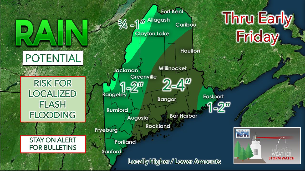 IMPACTS: Rain could be heavy at times during the day and becomes more of a concern Thursday afternoon (south) and evening (west, east, north) into early Friday morning. Localized flash flooding, reduced visibility from downpours, ponding on roadways, risk of hydroplaning on highways, along with areas of fog are all possible. Swells from Hurricane Larry in conjunction with astronomical high tides with the new moon will cause splash-over in low lying areas and minor flooding. High surf from the swells ranging 5-10 feet may cause some beach erosion along with life threatening rip currents. If you are going to view the waves, please respect the power and unpredictability of the ocean and view from a safe distance. DISCUSSION: Forecast remains on track for a slow-moving cold front to pass through the region Thursday into early Friday. As mentioned in the update posted here on Wednesday, concern that the forward progression of the frontal boundary would slow down a bit more appears to be occurring. The result of that is higher rainfall amounts, with most of the state guaranteed at least 1" of precipitation. Rain appears intermittent through most of the day. With the frontal boundary stalling out over the Maine / New Hampshire border, low pressure is expected to form along the front and travel southwest to northeast Thursday afternoon into early Friday. As the low slides along the front come the increased chance for heavy rainfall, along with an isolated chance of a thunderstorm. With the heavy rain comes the threat for localized flash flooding. The National Weather Service is contemplating a flood watch for MidCoast and eastern areas pending on review of new guidance and observations. With the region in the warm sector, dew point temperatures in the 60s along with precipitable water values pushing 1½-2" will make the air feel tropical. High temperatures for the day range from the upper 60s for the mountains and north to low 70s for the coastal plain. Wind out of the south ranges from 5-15 mph with gusts in the 20s for MidCoast and eastern areas through this evening. The front pushes through the region by Friday morning, with the last of steady precipitation ending over southwestern areas by 5-6 AM, western and eastern areas by 11 AM - noon, and northern areas by 1-2 PM. Isolated showers may pop up as high pressure moves in behind the front through the remainder of the daylight hours. Low temperatures to start Friday range from the mid-50s north and mountains to 60° for the coastal plain. High temperatures for Friday range from the mid-60s north and mountains to mid-70s for the coastal plain. With high pressure moving in on Friday, wind from the west/northwest at 5-15 mph with gusts 20-30 mph bring drier air into the region. The breeze continues into Saturday in the wake of Hurricane Larry's departure. Lows to start Saturday range from the mid-40s north and mountains to mid-50s for the coastal plain. As far as the weekend goes, Saturday appears dry and breezy with mainly sunny conditions. Highs range from the mid-60s north to mid-70s south. Sunday sees a chance for a morning shower in the mountains and north as a weak frontal boundary passes through. Highs in the low 70s north to low 80s south.  Flash Floods Whether you’re on the road or camping, will you be ready for sudden flash flooding? Make sure to enable Wireless Emergency Alerts on your phone. If flooding occurs while you’re outdoors, immediately get to higher ground, and NEVER enter flood waters in a vehicle or on foot. weather.gov/safety/flood Be prepared to receive alerts and stay updated!
For more information in between posts, please follow Pine Tree Weather on Facebook and Twitter.
Thank you for supporting this community-based weather information source which operates by reader supported financial contributions. Stay updated, stay on alert, and stay safe! - Mike |

Mike Haggett
|