Afternoon rain showers and thunderstorms return for Thursday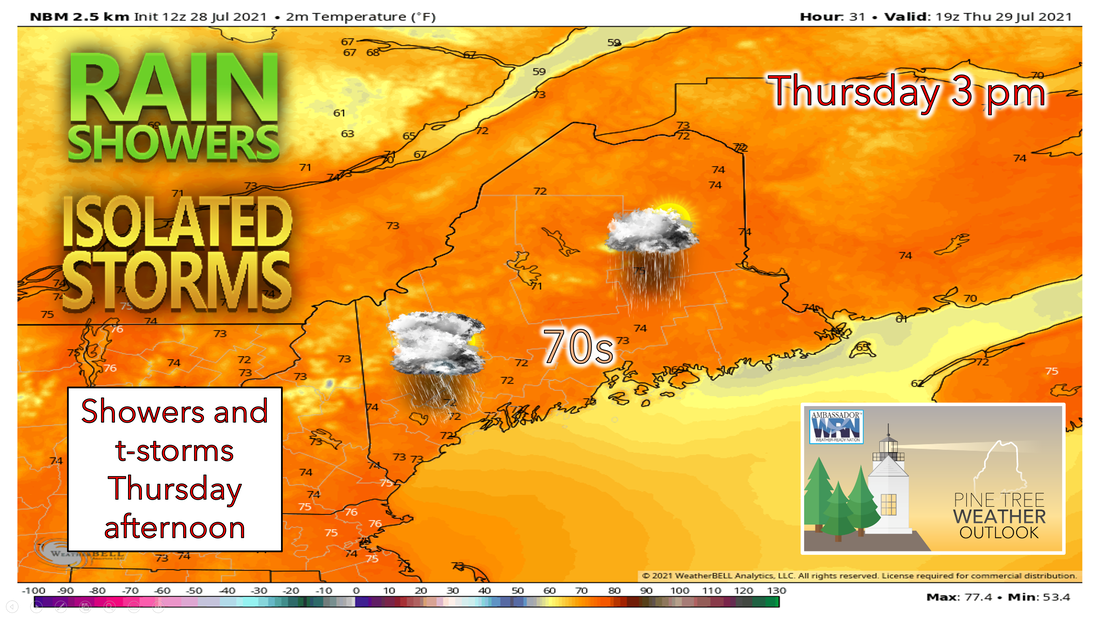 After a beautiful day with high pressure in control on Wednesday, clear skies tonight will allow for temperatures to cool substantially into the 40s and 50s once again. Some fog for river and valley regions is also possible overnight. The high pressure will eventually move eastward as a shortwave trough moves into the area behind it for Thursday. We may wake up to hazy skies Thursday morning with another patch of wildfire smoke overhead. However, it shouldn't be as thick as it was the past few days. Scattered showers and a possible rumble of thunder, primarily in central and southern Maine, will be associated with this upper-level disturbance. Skies further east should be mostly cloudy with a few more breaks in the clouds. It will be another cool day with highs again in the low to mid-70s across much of the state with more cloud cover present. As a result of southwesterly flow, a sea breeze is also likely to set up, preventing the coast from reaching 70 in most areas. Rain showers Thursday afternoon into Friday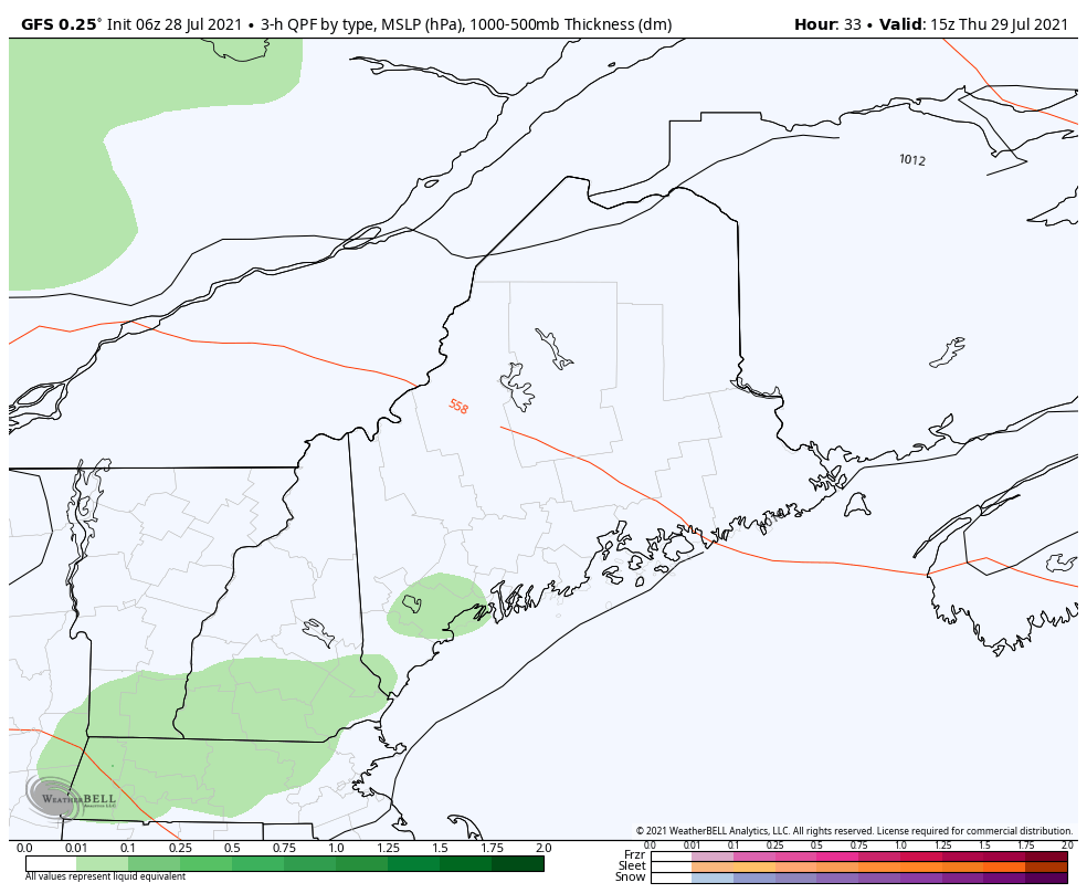 As of Wednesday afternoon, it looks like showers will move in late afternoon and evening on Thursday and continue overnight into early Friday as a warm front moves through the region. Some periods of heavy rain or a thunderstorm are possible at night and into the morning. Steadier rain will persist throughout the region as low pressure works into the area and a cold front passes through Thursday night, bringing some potential drought-relieving rain to the state. For Friday, a shortwave trough will approach from the west allowing for some scattered showers to develop during the afternoon primarily in southern and coastal regions. Humidity will also return, as moister air is drawn up from the south. Skies should be mostly sunny with temperatures in the 70s with the western mountains staying in the upper 60s. Rain amounts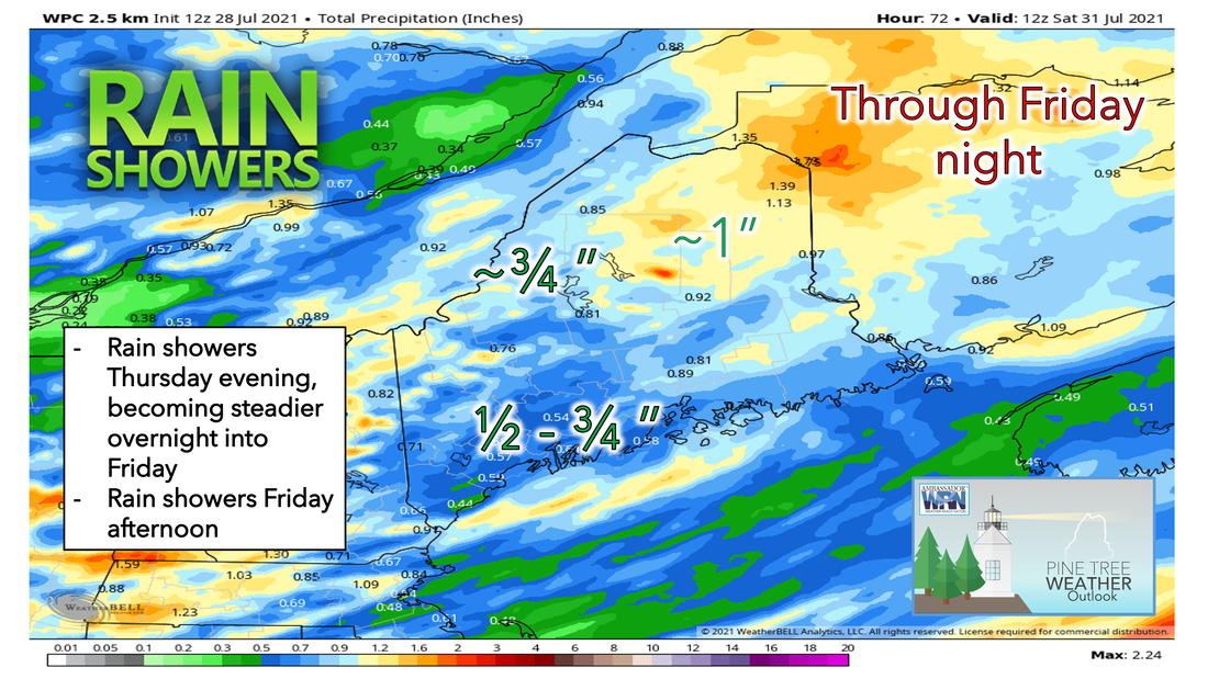 Beginning Thursday afternoon, we should see isolated showers and thunderstorms move into the area ahead of a system that will bring some steady rain during the overnight hours leading into the day on Friday. The system will move east during the day while producing lingering rain showers over central and northern Maine. Skies should be mostly cloudy towards the north and mostly sunny towards the south. During this two-day stretch, most are likely to receive ½ inches or more of rain which continues to help our ongoing drought situation. Be sure to check back for an updated and more detailed look at the drought monitor during the Thursday afternoon website discussion tomorrow. Weekend outlook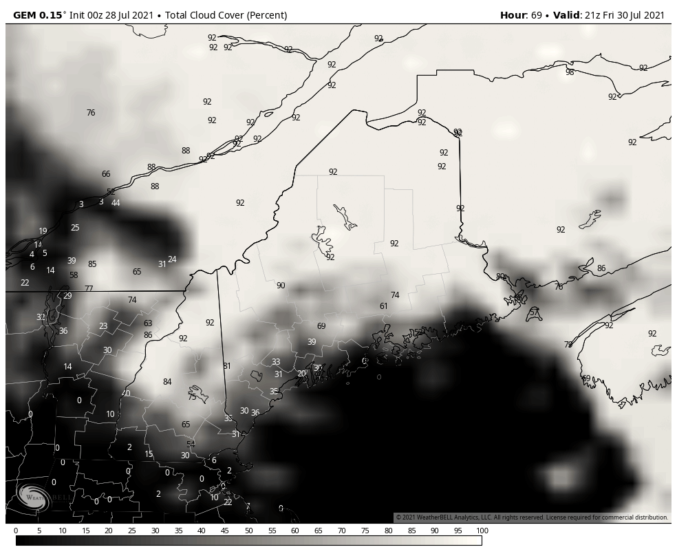 Drier and cooler air moves back in Friday night into Saturday with a cool night on tap Friday, some spots inland dropping into the 40s. Overall, the weekend is looking good with mostly sunny skies, low humidity, temperatures in the 70s on Saturday, and a chance for some showers late Sunday into Monday. Saturday looks to start the weekend off with dry conditions and mostly sunny skies. Temperatures, however, will be on the cooler side once again only reaching the 70s towards the south with 60s elsewhere. Sunday will bring the next chance for some rain and increased cloud cover during the night into Monday as a low-pressure system works into the area. Beginning of the next workweek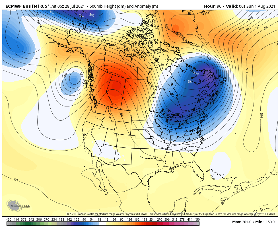 The closed upper-level ridge over the south-central U.S will gradually weaken and builds over the Rockies into Western Canada. The ridge amplitude will support deep and persistent eastern U.S/Canada upper trough. This pattern favors average to slightly below average temperatures from the Northeast and Mid-Atlantic with continuous chances of late-day storms. But we will see plenty of sunshine during the day and drier conditions compared to previous weeks. mPING Check out mPING (Meteorological Phenomena Identification Near the Ground) project. Weird name, cool app! You can report the type of precipitation you see where you are. No need to measure! Use the free mobile app to send reports anonymously. Reports are automatically recorded into a database, which improves weather computer models. The information is even used by road maintenance operations and the aviation industry to diagnose areas of icing. mping.nssl.noaa.gov Temperature outlook through early AugustThe plots below show the trend of the high and low temperatures for Carrabassett, Bangor, Caribou, and Portland over the next week and a half. A cooler trend will be persistent ahead into next week with temperatures remaining in the 60s and 70s. Temperatures will be below average for some areas. Temperatures will begin to increase very slowly heading into next weekend. 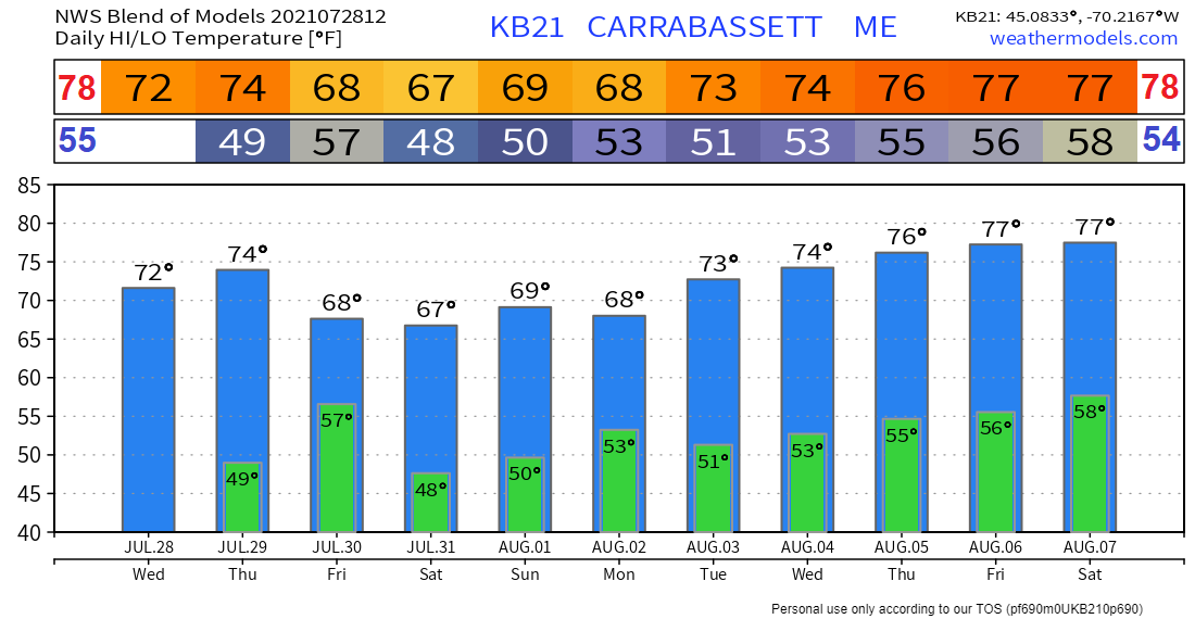 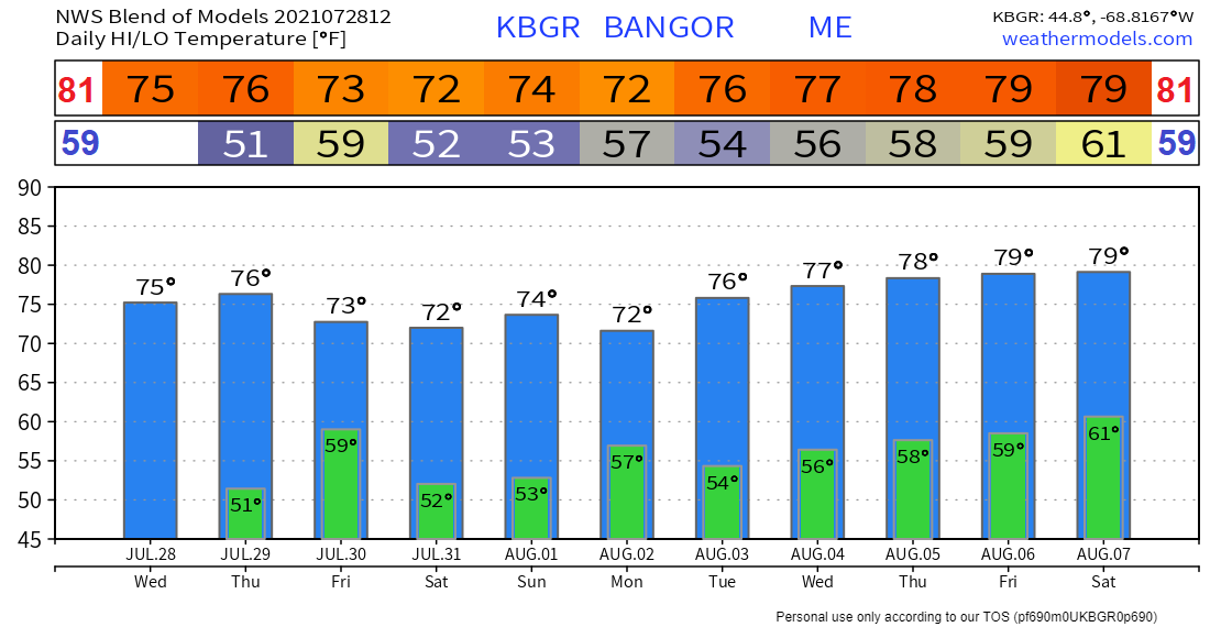 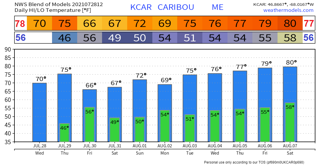 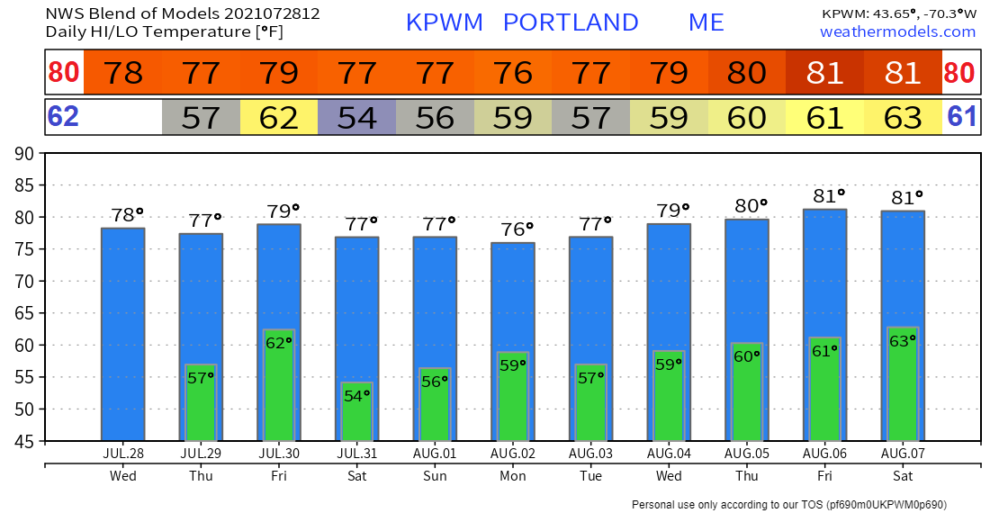 Be prepared to receive alerts and stay updated!
For more information in between posts, please follow Pine Tree Weather on Facebook and Twitter.
Thank you for supporting this community-based weather information source which operates by reader supported financial contributions. Stay updated, stay on alert, and stay safe! |

Mike Haggett
|