Isolated Showers and Thunderstorms Possible Today, Heat Wave Begins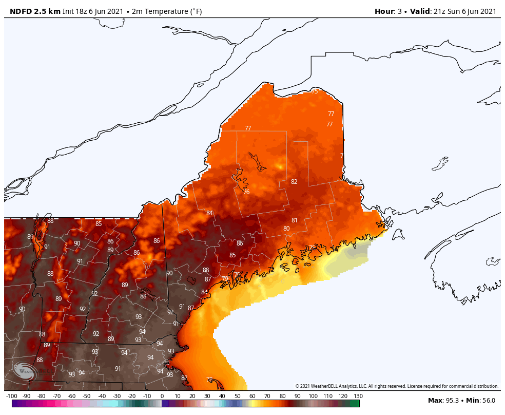 There will be a chance of isolated showers and thunderstorms across portions of the state later this afternoon and evening. These pop-up showers and thunderstorms are most favored to develop over Downeast Maine. These thunderstorms will be initiated by a frontal boundary positioned over the Central Highlands. Any thunderstorms that do develop later today should be non-severe, unlike yesterday's severe thunderstorms across the region. This afternoon and evening the area of wind shear which is a necessary ingredient for severe thunderstorm development will be displaced from the area of highest CAPE (convective available potential energy) likely yielding single cell thunderstorms with gusty winds being the primary threat. Many areas across the region have already hit their high temperatures for the day with 70's common for the shoreline locales due to the sea breeze as well as the northwestern portion of the state and upper 80's to lower 90's common across the interior and southwestern Maine. Tonight expect mild temperatures in the low to mid-60's with areas of patchy fog possible for the shoreline locations given the clearing skies.  Record Challenging Heat Tomorrow and Tuesday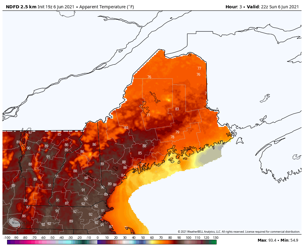 This is an animation of the apparent temperature which represents how hot it feels outside by taking into account temperature and humidity. 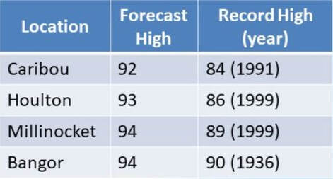 Forecasted high temperatures for Caribou, Houlton, Millinocket, and Bangor for tomorrow compared to the record high temperature for that date. High temperatures tomorrow and Tuesday are likely to be about 15-25 degrees above normal for this time of year with record breaking heat likely across portions of the state. High temperatures should reach the low to mid-90's for Downeast Maine, SW Maine, and interior locations tomorrow with mid to upper 80's possible for the Highlands and 70's and 80's for the shoreline locations with the sea breeze. Additionally, it will be humid tomorrow with dewpoints around 60-65 degrees which will make temperatures feel even hotter. This is because when the humidity rises the human body has a harder time cooling itself off since in more humid conditions your sweat doesn't evaporate as readily. Be cautious tomorrow if you are going to be working or exercising outdoors and make sure to hydrate and take frequent breaks. Tuesday is likely to be a few degrees cooler than Monday; however, temperatures will still rise into the upper 80's to lower 90's for many locations in the state. The humidity will remain high on Tuesday making temperatures feel hotter than they really are. Temperature outlook through mid-JuneThe bar graphs display the projected high temperatures (yellow bars)/low temperatures (blue bars) for the next and a half for Bangor, Caribou, Millinocket, and Portland. After record breaking heat expected tomorrow and Tuesday, we will begin to see the transition to a more seasonable weather pattern on Wednesday. On Wednesday, scattered showers and thunderstorms will be possible as a cold front stalls over Downeast Maine. The cold front will likely pass through the state on Wednesday night bringing relief from the unseasonably warm temperatures. Thursday is likely to be much cooler statewide with high temperatures expected in the 60's and 70's statewide as a cool Canadian high pressure system builds in from the north. Temperatures will remain quite seasonable into next weekend with a chance of showers. 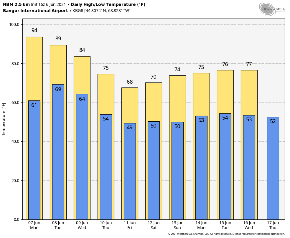 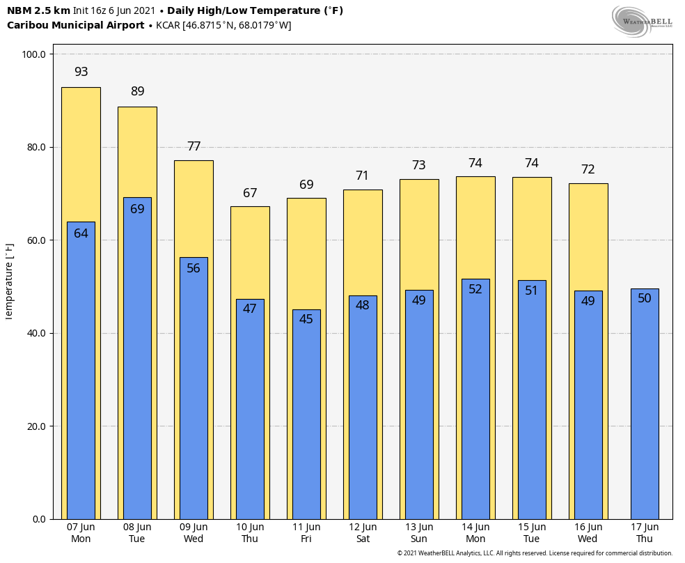 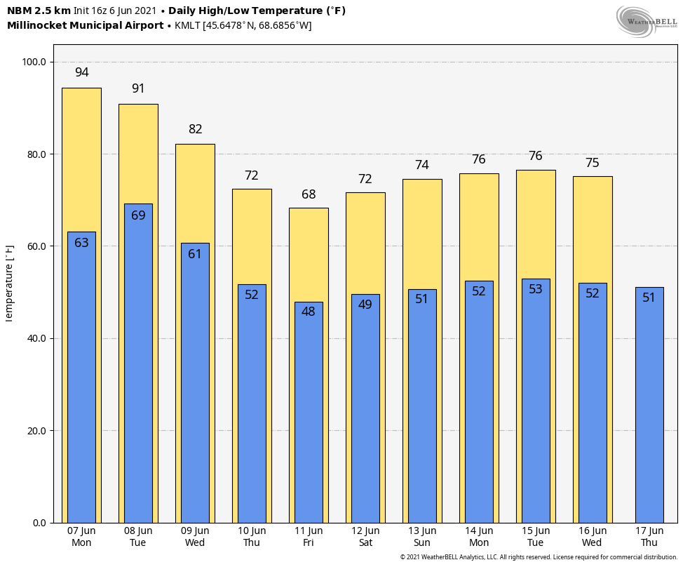 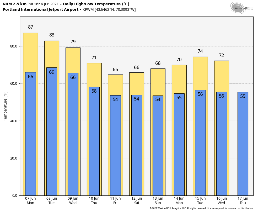 Heat Impacts for Vulnerable Populations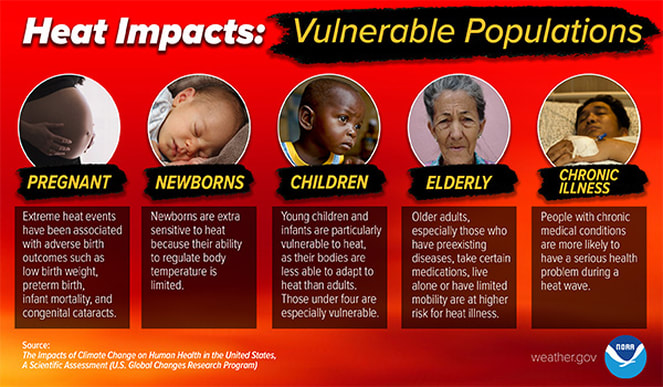 Heat is one of the leading weather-related killers in the United States, resulting in hundreds of fatalities each year. Heat can be very taxing on the body; check out the heat related illnesses that can occur with even a short period of exposure. Everyone can be vulnerable to heat, but some more so than others. According to The Impacts Of Climate Change On Human Health In The United States: A Scientific Assessment the following groups are particularly vulnerable to heat; check in with friends and relatives who fall in one of these populations, especially if they don’t have air conditioning. Be prepared to receive alerts and stay updated!
For more information in between posts, please follow Pine Tree Weather on Facebook and Twitter.
Thank you for supporting this community-based weather information source which operates by reader supported financial contributions. Stay updated, stay on alert, and stay safe! |

Mike Haggett
|