Pine Tree Weather
  • DISCUSSIONS
  • DONATE
  • WEATHER WALL
  • MAPS
  • RAIN OUTLOOK
  • SEVERE
  • MARINE
  • CPC OUTLOOK
  • Kennebunk
  • MY BIO
  • PTW IN MEDIA
  • OBSERVING WEATHER
  • INTERNSHIPS
  • INTERN ALUMNI
  • DISCUSSIONS
  • DONATE
  • WEATHER WALL
  • MAPS
  • RAIN OUTLOOK
  • SEVERE
  • MARINE
  • CPC OUTLOOK
  • Kennebunk
  • MY BIO
  • PTW IN MEDIA
  • OBSERVING WEATHER
  • INTERNSHIPS
  • INTERN ALUMNI

Relatively quiet for Maine until Christmas Eve

12/21/2020

Comments

 
Picture

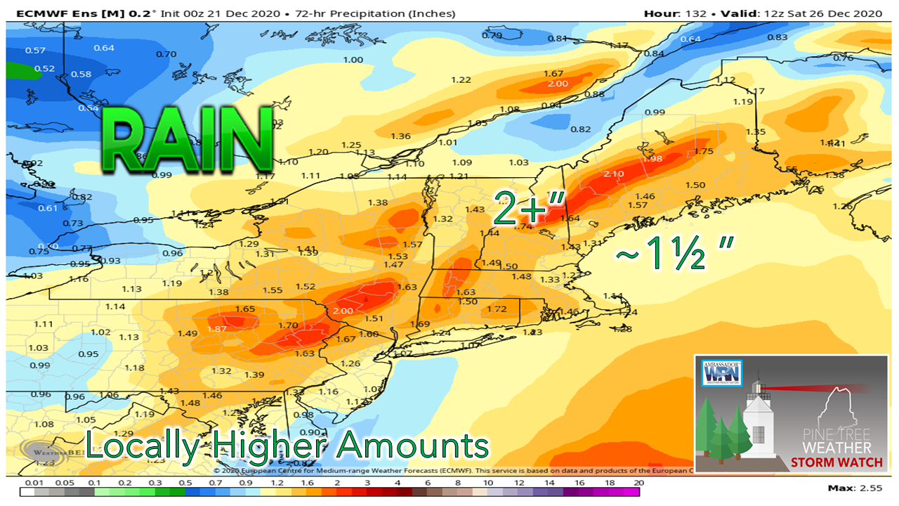
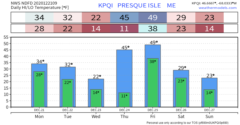
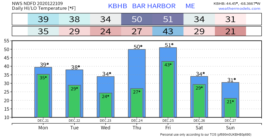
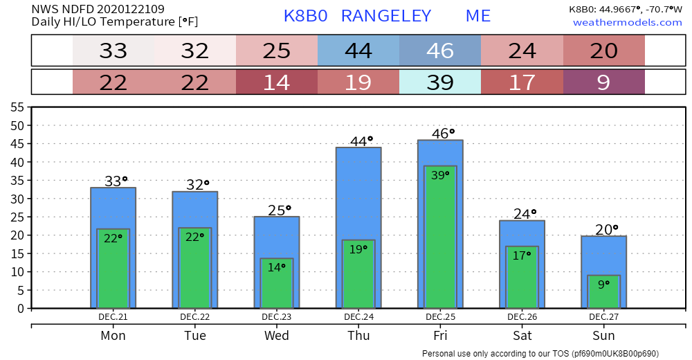
Best chance for sun in western areas Monday

Picture
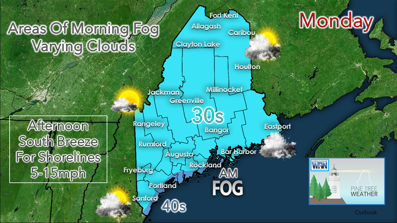
If you are playing hooky and skiing today, it will be a good day for it. There could be some fog on the southern slopes, but the Rangeley / Sugarloaf region should be in good shape to start off. Fog may be persistent in areas, so be aware of that.

Most if not all areas get up above freezing for the day. Southwest and MidCoast shorelines have the best chance to break 40°.

DownEast areas may pick up some light snow
​Monday Night

Picture
HRRR model idea of radar reflectivity from 3 PM Monday to 3 AM Tuesday
There is still some variance in ideas in track for this offshore storm passing to the southeast of the region Monday night into Tuesday. A majority of ideas indicate a close shave. If the track moves 30-60 miles to the northwest, that could bring an inch or two of snow to interior Washington County. Bangor may pick up a dusting in that scenario. 

Precipitation ends by 1-2 AM regardless.

For Tuesday, similar in temperature, a bit more wind from the west, with a chance for snow showers in mountains as a Canadian High works into the region.

​Wednesday appears cooler, but quiet as high pressure sets up for the day. 

Storm remains on track to bring impacts for Christmas

Picture
GEM model idea of surface pressure and precipitation from 7 PM Wednesday to 7 PM Saturday
High pressure that brings fair conditions to the region passes east Wednesday night. A southwest flow develops. Far northern areas may get clipped with some snow showers heading into Thursday morning. Outflow rain showers ahead of the longwave frontal boundary could initiate Christmas Eve late morning or early afternoon. The main punch of this storm appears to  happen overnight into Christmas Day.
Picture
European Ensemble idea for probability of wind gust speed greater than 50 knots from 7 PM Thursday to 1 AM Saturday
Wind and power outages is my first concern with this storm. The loop above shows the percentage chance of wind gust speeds exceeding 50 knots near the surface. Guidance is depicting a strong low level jet which could peak with wind gusts around 80 knots at 2,000 feet above the surface Christmas morning. Add the probability for downpours and thunderstorms into the mix, that sets up the scenario where the wind threat is not only horizontal, but vertical. 

The National Weather Service is indicating the possibility of high wind concerns for the coastline and advisory level wind for interior areas. 

As we have seen in storms like this in the recent past, a strong south/southeast flow sets up the idea of power outages. For those who live in areas where power frequently cuts out, you are on notice now to prepare for it to happen. 
Picture
Ensembles are still on the idea of a 1½-2"+ idea for rainfall for most of the region, which remains a good base in amounts to get started with. Actual totals could be double that, especially in the mountains. This will be fine tuned as we get closer.

Localized flash flooding, urban street flooding, ponding of water on roadways, potential for hydroplaning, reduced visibility in areas of fog and heavy rain are all on the table Christmas Day.

As the front passes through late Friday, temperatures drop. All of this will freeze up heading into Saturday morning, and may freeze very quickly on the roads overnight. 

Please support Pine Tree Weather

Picture

Outlook through Sunday

With the rain event for Christmas, a record high temperature could be broken for Caribou, and come close for Houlton and Millinocket. For those looking for the next snow chance of significance, there may be something in the works in the 8-10 day region. 
Picture
Picture
Picture
Picture
Picture

Holiday power outages are not fun

Picture
Power outages are becoming more numerous and more impactful around Maine. With a holiday on the way, you may want to cook ahead and prepare for power loss.

​For power loss preparation tips ready.gov/power-outages

Be prepared to receive alerts and stay updated!

Picture
​​BE PREPARED WITH A NOAA Weather Radio.

​For $20-$40, it could provide important information to you when you need it. The weather bands are standard on most public safety scanners, and newer scanner models. Weather radios can be programmed for auto alert.  Click here for more information.

​► ► For the latest official forecasts, bulletins and advisories, please check in with the National Weather Service in Gray for western and southern areas, or Caribou for northern and eastern parts of Maine
Picture

For more information, please follow Pine Tree Weather on Facebook and Twitter. 

** FUNDING NEEDED FOR 2021 **
​Thank you for supporting this community based weather information source that is funded by your financial contributions. 


Stay updated, stay on alert, and stay safe!

​- Mike
Comments
    Picture

    Mike Haggett
    Kennebunk, ME

    Weather-Ready Nation
    Ambassador

    Certified Weather
    Forecaster
    Penn State '21

    American Meteorological Society

    National Weather Association
    ​
    ​SKYWARN-CWOP

    Matthew 19:26


    DONATE

    Picture
    Picture
    Picture
    Picture
    Picture

    Picture

    Picture

    Picture

    Picture

    Picture

    Picture

    Picture

    Picture

    Picture

    Picture

    Picture

    Picture


    Archives

    April 2025
    March 2025
    February 2025
    January 2025
    December 2024
    November 2024
    October 2024
    September 2024
    August 2024
    July 2024
    June 2024
    May 2024
    April 2024
    March 2024
    February 2024
    January 2024
    December 2023
    November 2023
    October 2023
    September 2023
    August 2023
    July 2023
    June 2023
    May 2023
    April 2023
    March 2023
    February 2023
    January 2023
    December 2022
    November 2022
    October 2022
    September 2022
    August 2022
    July 2022
    June 2022
    May 2022
    April 2022
    March 2022
    February 2022
    January 2022
    December 2021
    November 2021
    October 2021
    September 2021
    August 2021
    July 2021
    June 2021
    May 2021
    April 2021
    March 2021
    February 2021
    January 2021
    December 2020
    November 2020
    October 2020
    September 2020
    August 2020
    July 2020
    June 2020
    May 2020
    April 2020
    March 2020
    February 2020
    January 2020
    December 2019
    November 2019
    October 2019
    September 2019
    August 2019
    July 2019
    June 2019
    May 2019
    April 2019
    March 2019
    February 2019
    January 2019
    December 2018
    November 2018
    October 2018
    September 2018
    August 2018
    July 2018
    June 2018
    May 2018
    April 2018
    March 2018
    February 2018
    January 2018
    December 2017
    November 2017
    October 2017

Proudly powered by Weebly