Warm and humid on Friday as Fred moves off the coast, mugginess continues through the weekend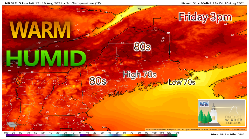 The remnants of what was once Tropical Storm Fred continue to bring heavy rainfall to southern Maine on Thursday evening. The precipitation likely lasts through the overnight hours as the storm moves west to east. There is still some uncertainty regarding just how quickly the low-pressure system moves off the coast. There is a possibility that the rain will linger near the Midcoast on Friday, bringing extra rounds of showers and lighter rainfall to central Maine. Another more probable scenario is for the heavy rain to makes its way towards the Downeast area on Friday morning, before a disturbance aloft helps to push the system off towards Nova Scotia. In this case, gradual clearing is likely to occur through Friday afternoon, allowing high temperatures to reach the 80s. Northern Maine looks to stay mostly dry during the day, regardless of Fred's track. Expect partly sunny skies and very warm, humid conditions. A weak cold front is projected to track through on Friday evening, resulting in some scattered showers. This may knock the dew points down a few degrees for Saturday. 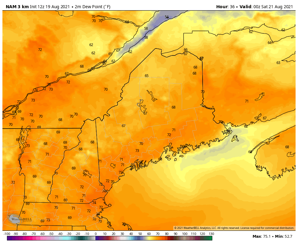 Despite the remnants of Fred making its exit, humid conditions appear to persist for much of the weekend. On Saturday, dew points likely hover around 70° F in the south. Northern regions of Maine look to be less sticky with dew points in the lower 60s. An upper-level trough is expected to develop across the region, resulting in unsettled conditions. Chances for showers are likely throughout Saturday and Sunday, with a southerly flow carrying in moisture and warm air. Keeping a watchful eye on Henri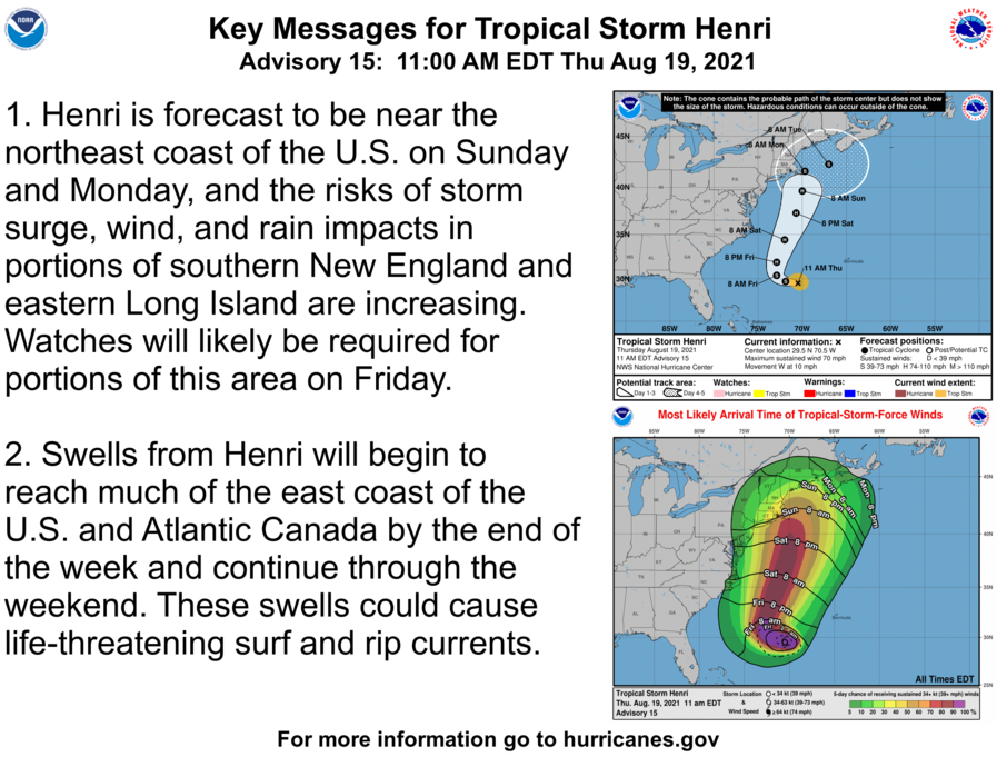 The exact path and varying intensity of Henri remains uncertain, but it is important to discuss potential impacts as several models suggest that the storm will affect our region to some degree. The current track issued by the National Hurricane Center has Henri moving up the Eastern Seaboard throughout this weekend before arriving in New England sometime late Sunday. Potential impacts for Maine look to begin sometime early Monday into Tuesday. At the very least, rough surf along the coast is growing increasingly likely. Other impacts include heavy rain, flooding, high winds, and strong rip currents. This is all dependent on how close Henri gets to New England and to what extent the storm intensifies. Henri is currently classified as a Tropical Storm but is expected to strengthen into a Category 1 Hurricane by Friday. 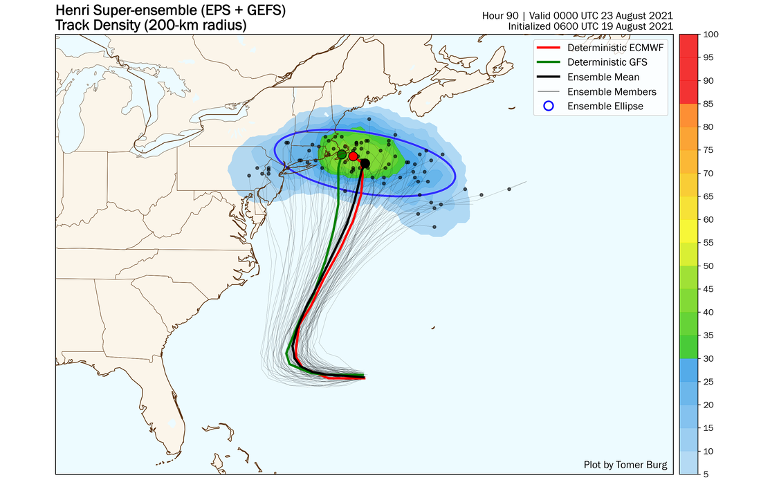 This spaghetti-plot created by Tomer Burg further showcases the uncertainty regarding Henri's path. The assortment of dots represents potential locations of the storm by 8pm Sunday night. While there is a significant cluster indicating a more direct hit near coastal Massachusetts, there is also potential for Henri to turn east into the Atlantic Ocean. Forecast confidence will continue to grow on Friday and throughout the weekend, so be sure to check back for updates! For now, prepare for potential impacts from Henri, especially if you live near the coast. Check your generators and secure loose outdoor objects. Have an evacuation plan in place if you are in an area subject to flooding.  Drought Monitor Thursday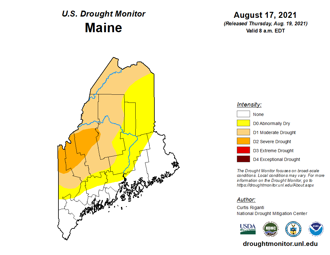 Unfortunately for those who continue to feel the effects of the ongoing drought, there has been little to no change since last week's update. The coastal areas of Maine continue to reap the benefits of the very wet July, but dry conditions prevail further inland. Portions of Oxford, Franklin, and Somerset counties remain in the Severe Drought category, represented by the darker orange color. The lighter orange shade indicates Moderate Drought, which extends into northern Aroostook and much of Piscataquis County. Counties shaded yellow are currently at level D0 - Abnormally Dry. 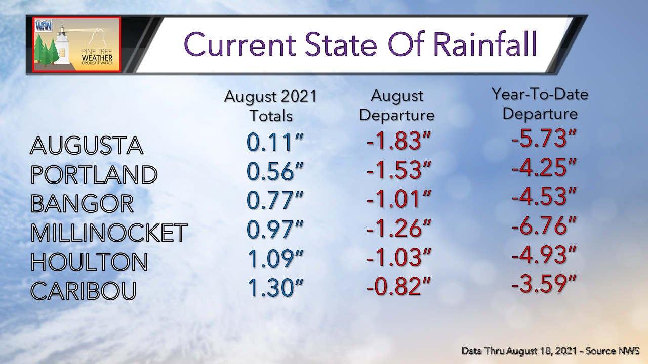 Looking at the month of August so far, the entire state has been trending dry. Many locations have departed upwards of one inch to nearly two inches from the month's normal rainfall. This dryness only exacerbates the drought in western and northern Maine. The dry winter and spring haven proven very difficult to overcome as YDT departures from normal range from about 4" to well over 6". 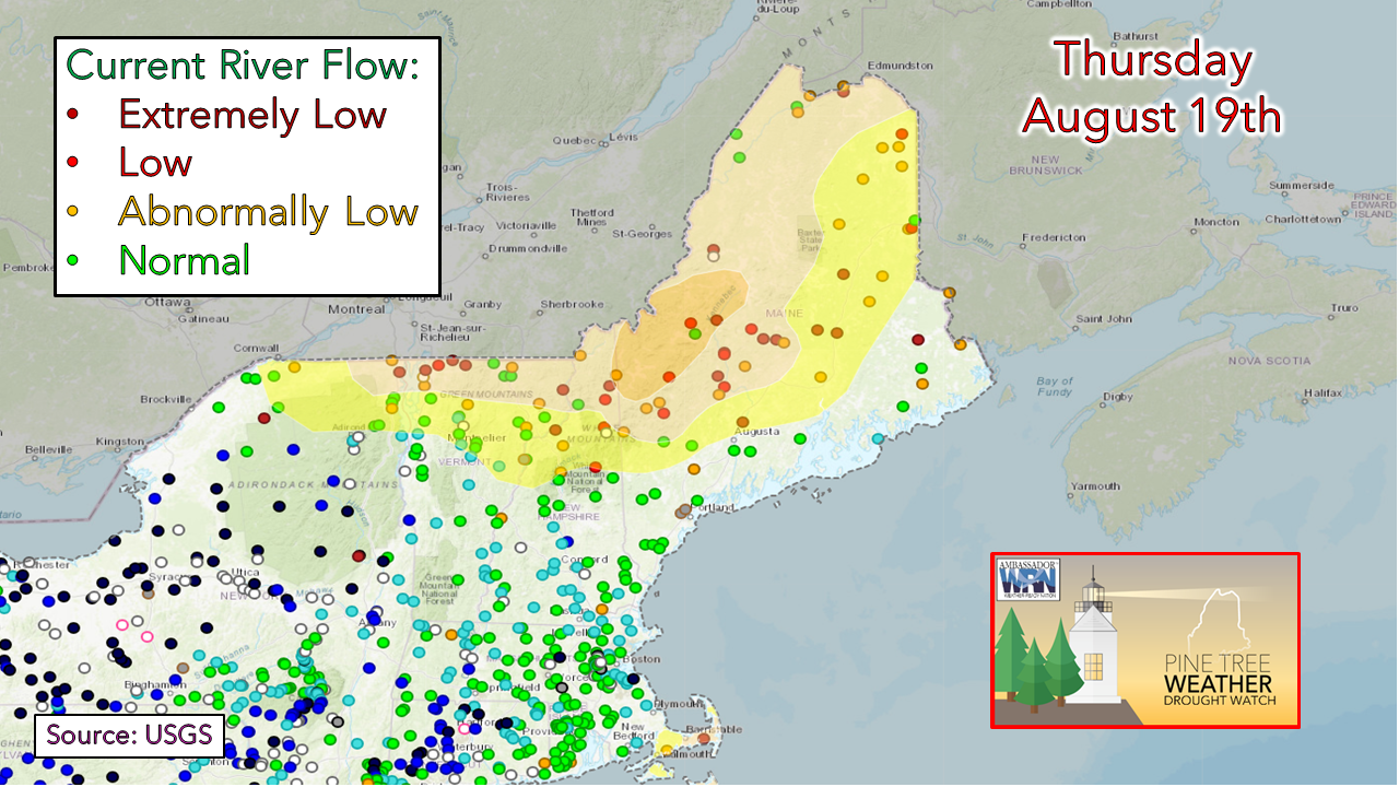 Matching up similarly to the current areas of drought, river flow continues to run low in western and northern portions of the state. This will likely continue as long as the rainfall deficits persist in these locations. 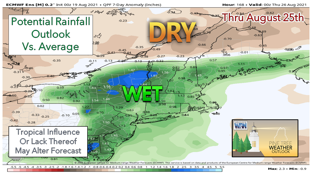 Looking forward to the next 7 days, much of New England appears wetter than average. This is due to the current forecast that has Tropical Storm Henri tracking up towards the coast, bringing the potential for significant rainfall. There is a sharp contrast between northern and southern Maine in terms of total rainfall. The north appears to remain very dry, missing out on any tropical influence. Secure Your Boat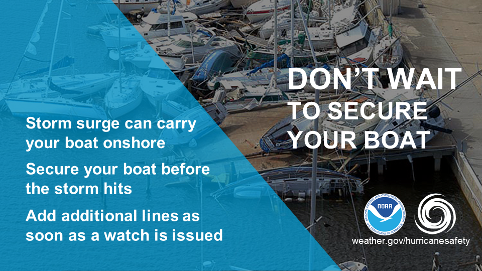 Don't wait for a Tropical Storm or Hurricane Warning to secure your boat. By then it's too late to safely work on a dock. Listen to weather forecasts and plan ahead. Haul out your boat or add additional lines as soon as a tropical storm or hurricane watch is issued. This will typically give you 48 hours before the anticipated onset of storm winds and will allow you to safely secure your boat. weather.gov/safety/safeboating-before Temperature outlook through WednesdayHigh temperatures on Friday appear very warm in the north, reaching the upper 80s. The southern half of the state will likely be in the lower 80s due to the increased cloud cover to start the day. Saturday appears seasonably warm with a slight cool-down on Sunday and Monday as Henri approaches. 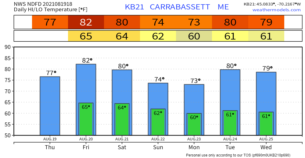 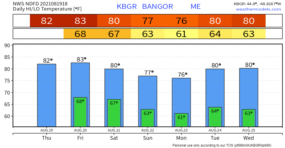 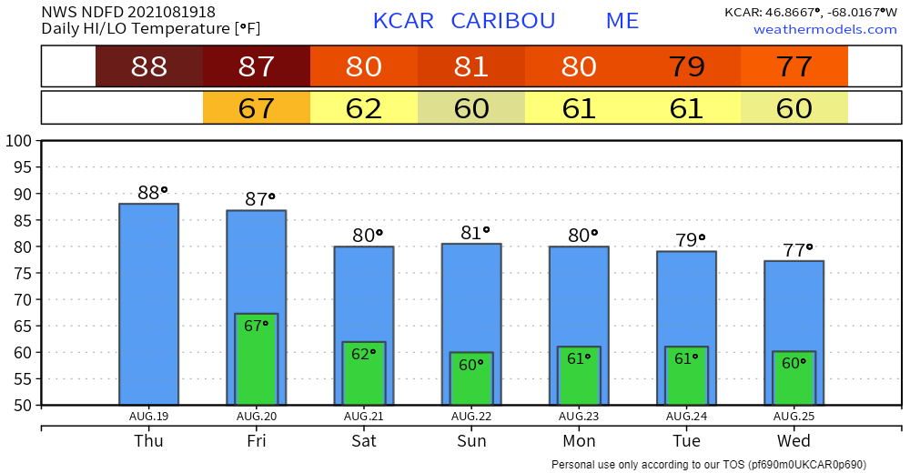 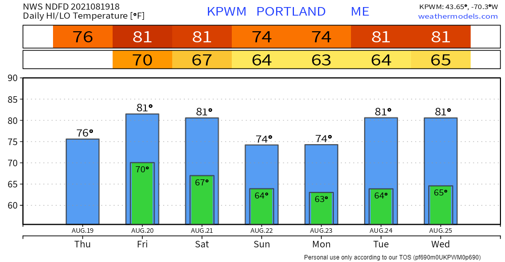 Be prepared to receive alerts and stay updated!
For more information in between posts, please follow Pine Tree Weather on Facebook and Twitter.
Thank you for supporting this community-based weather information source which operates by reader supported financial contributions. Stay updated, stay on alert, and stay safe! |

Mike Haggett
|