Pine Tree Weather
  • DISCUSSIONS
  • DONATE
  • WEATHER WALL
  • MAPS
  • RAIN OUTLOOK
  • SEVERE
  • MARINE
  • CPC OUTLOOK
  • Kennebunk
  • MY BIO
  • PTW IN MEDIA
  • OBSERVING WEATHER
  • INTERNSHIPS
  • INTERN ALUMNI
  • DISCUSSIONS
  • DONATE
  • WEATHER WALL
  • MAPS
  • RAIN OUTLOOK
  • SEVERE
  • MARINE
  • CPC OUTLOOK
  • Kennebunk
  • MY BIO
  • PTW IN MEDIA
  • OBSERVING WEATHER
  • INTERNSHIPS
  • INTERN ALUMNI

Remnants of Ida to bring a warm NorEaster to Maine

9/1/2021

Comments


The state is on the fringe

Picture
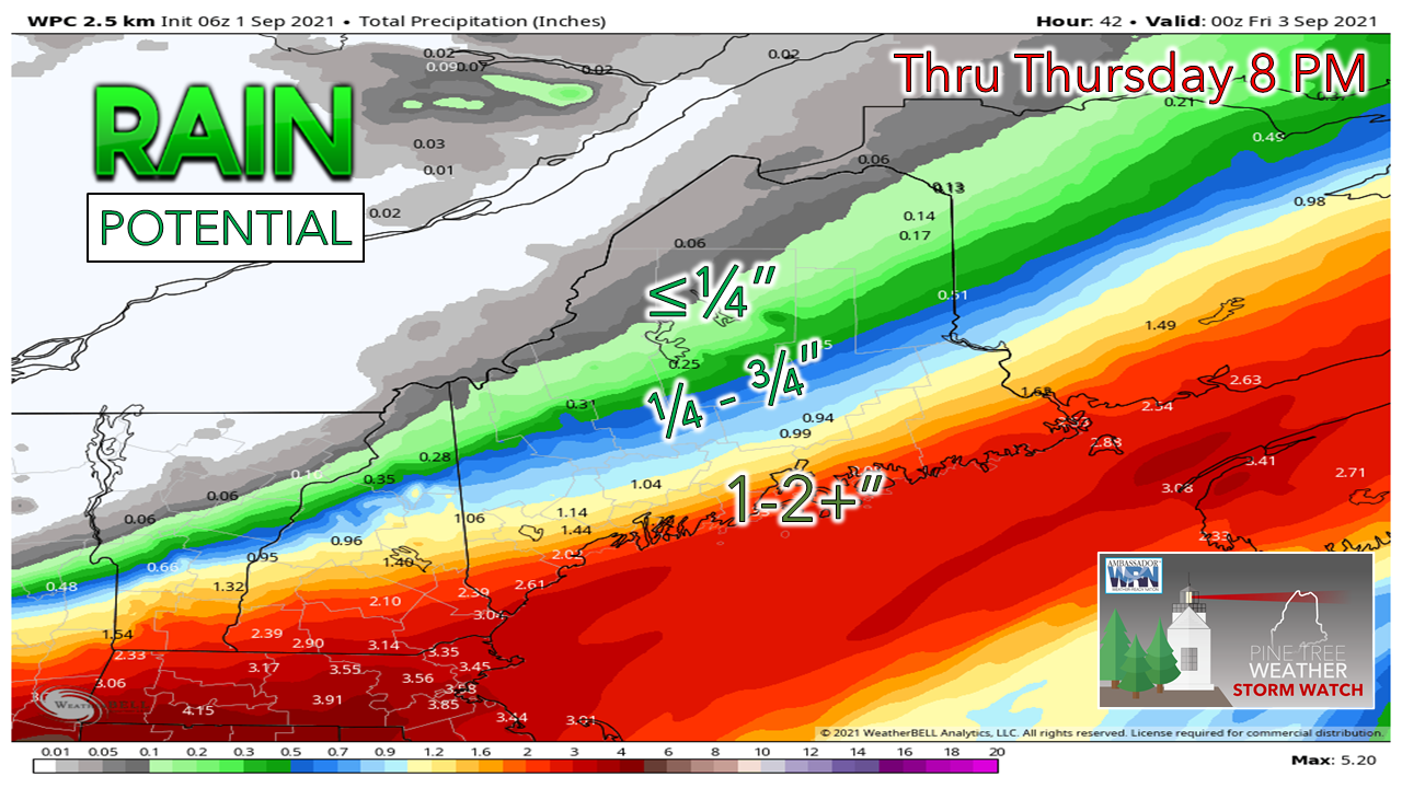
I'll be right up front here to say there is high bust and boom potential with this. The remnants of Ida is on track to develop into a wet NorEaster, which we know from winter experience can bring the chance for surprises. 

As I mentioned on Tuesday, the influence of the upper low dropping down over eastern Quebec holds the cards on how this will play out. Less influence, less rain for the interior. More influence, more rain for the interior, and higher rain totals for the coast. In this prepared Weather Prediction Center idea is about as close to the happy medium there is between various operational and ensemble ideas. 

A flood watch is in effect for York County. Time will tell if that area is expanded to include more counties. Coastal plain counties should stay on alert for changes. 

A quiet Wednesday

Picture
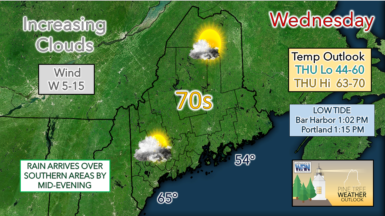
Ahead of the arrival of what is left of Ida is a relatively calm. More sun to the north to start off, but by late afternoon the cloud cover makes it to the far north as warm air intrudes into the upper levels of the atmosphere.  Most of the daylight hours stay dry.

Timing of rainfall and wind

Picture
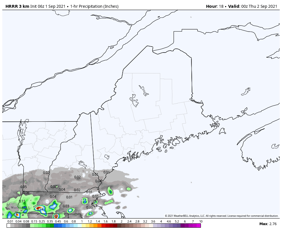
Looking at 1-hour forecast rain totals from the 06z (2 AM) HRRR model run for timing purposes shows rain developing over southwestern Maine by 8 PM Wednesday evening and reaching far eastern areas by 3-4 AM. The morning commute Thursday is guaranteed to be a wet one for the coastal plain.
Picture
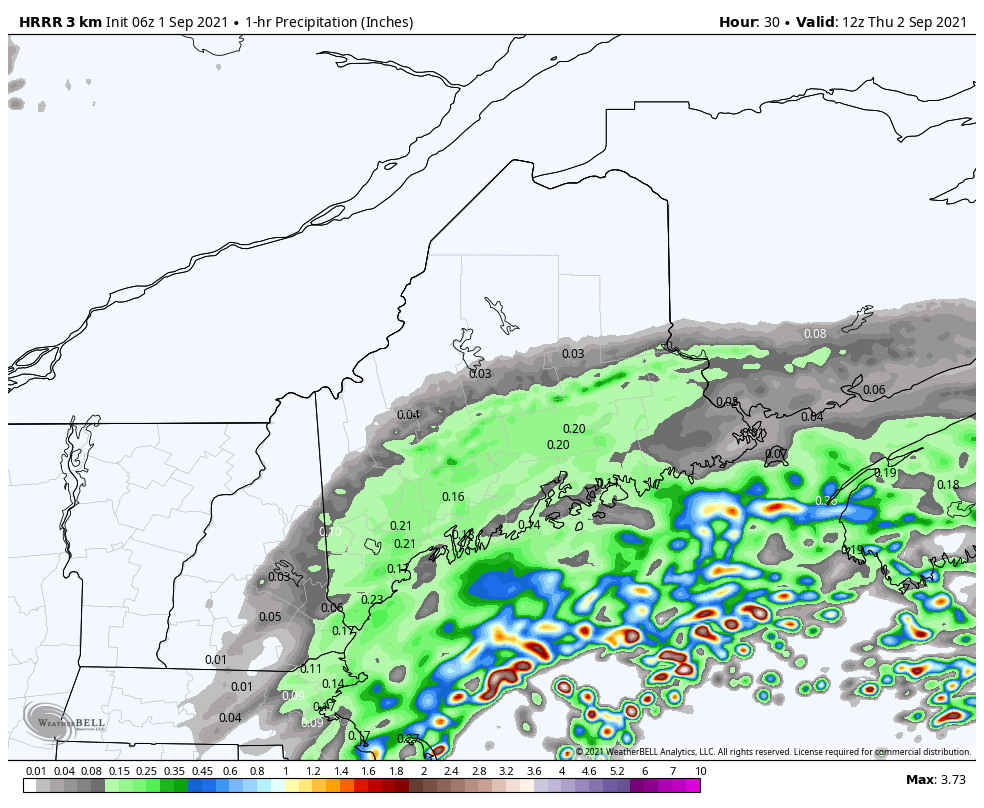
From 8 AM to 8 PM Thursday, steady rain ends over western and southern areas by roughly mid-morning, early afternoon for Bangor, and late afternoon for eastern areas. 
Picture
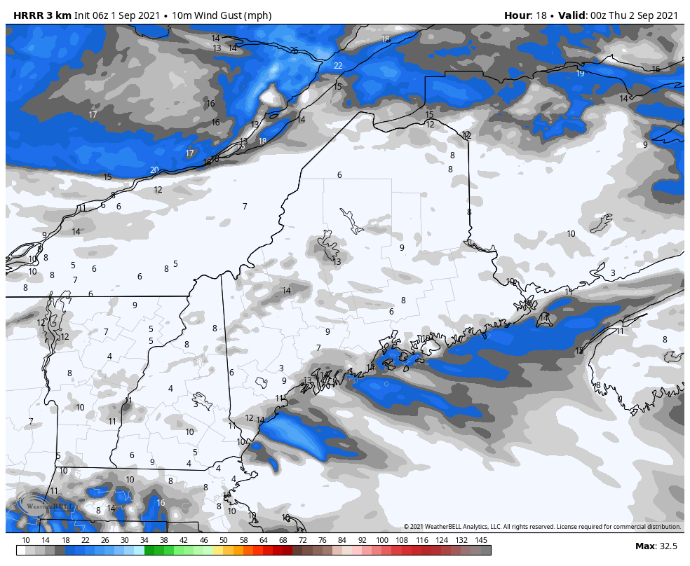
The wind factor through the period shows the higher wind gusts east of Penobscot Bay where northeasterly winds could reach into the 30-35 mph range. The storm is on track to intensify as it heads into the Canadian Maritimes. Wind over DownEast areas diminish heading into early Friday.

Picture

Picture

Outlook for Labor Day Weekend

Picture
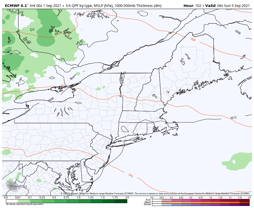
One Ida's remnants clear out, high pressure works in behind it and controls the pattern Friday and Saturday. Starting Sunday, ridging from the south noses northeastward, and brings the chance for a late day shower / thunderstorm on Sunday. Showers with a chance of a storm continue overnight into Monday. Humidity levels rise bringing sticky dew points to wrap up the holiday weekend, and potentially unsettled conditions. 
Picture
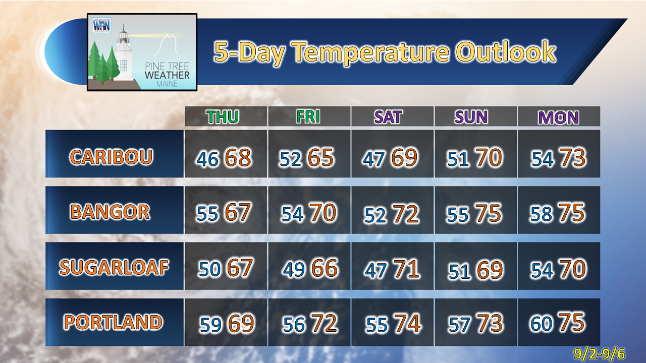
While the tail end of the weekend appears humid, temperatures are expected to run below normal overall for most areas through the period. 

Be prepared to receive alerts and stay updated!

Picture
BE PREPARED WITH A NOAA Weather Radio.
​
​For $20-$40, it could provide vital information to you when you need it. The weather bands are standard on most public safety scanners, and newer scanner models. Weather radios can be programmed for auto alert. Click here for more information.

​► ► For the latest official forecasts, bulletins, and advisories, please check in with the National Weather Service in Gray for western and southern areas, or Caribou for northern and eastern parts of Maine.
Picture

For more information in between posts, please follow Pine Tree Weather on Facebook and Twitter. 

​Thank you for supporting this community-based weather information source which operates by reader supported financial contributions. 

Stay updated, stay on alert, and stay safe!

​- Mike
Comments
    Picture

    Mike Haggett
    Kennebunk, ME

    Weather-Ready Nation
    Ambassador

    Certified Weather
    Forecaster
    Penn State '21

    American Meteorological Society

    National Weather Association
    ​
    ​SKYWARN-CWOP

    Matthew 19:26


    DONATE

    Picture
    Picture
    Picture
    Picture
    Picture

    Picture

    Picture

    Picture

    Picture

    Picture

    Picture

    Picture

    Picture

    Picture

    Picture

    Picture

    Picture


    Archives

    May 2025
    April 2025
    March 2025
    February 2025
    January 2025
    December 2024
    November 2024
    October 2024
    September 2024
    August 2024
    July 2024
    June 2024
    May 2024
    April 2024
    March 2024
    February 2024
    January 2024
    December 2023
    November 2023
    October 2023
    September 2023
    August 2023
    July 2023
    June 2023
    May 2023
    April 2023
    March 2023
    February 2023
    January 2023
    December 2022
    November 2022
    October 2022
    September 2022
    August 2022
    July 2022
    June 2022
    May 2022
    April 2022
    March 2022
    February 2022
    January 2022
    December 2021
    November 2021
    October 2021
    September 2021
    August 2021
    July 2021
    June 2021
    May 2021
    April 2021
    March 2021
    February 2021
    January 2021
    December 2020
    November 2020
    October 2020
    September 2020
    August 2020
    July 2020
    June 2020
    May 2020
    April 2020
    March 2020
    February 2020
    January 2020
    December 2019
    November 2019
    October 2019
    September 2019
    August 2019
    July 2019
    June 2019
    May 2019
    April 2019
    March 2019
    February 2019
    January 2019
    December 2018
    November 2018
    October 2018
    September 2018
    August 2018
    July 2018
    June 2018
    May 2018
    April 2018
    March 2018
    February 2018
    January 2018
    December 2017
    November 2017
    October 2017

Proudly powered by Weebly