Pine Tree Weather
  • DISCUSSIONS
  • DONATE
  • WEATHER WALL
  • MAPS
  • RAIN OUTLOOK
  • SEVERE
  • MARINE
  • CPC OUTLOOK
  • Kennebunk
  • MY BIO
  • PTW IN MEDIA
  • OBSERVING WEATHER
  • INTERNSHIPS
  • INTERN ALUMNI
  • DISCUSSIONS
  • DONATE
  • WEATHER WALL
  • MAPS
  • RAIN OUTLOOK
  • SEVERE
  • MARINE
  • CPC OUTLOOK
  • Kennebunk
  • MY BIO
  • PTW IN MEDIA
  • OBSERVING WEATHER
  • INTERNSHIPS
  • INTERN ALUMNI

Saturday December 2, 2023

12/2/2023

Comments


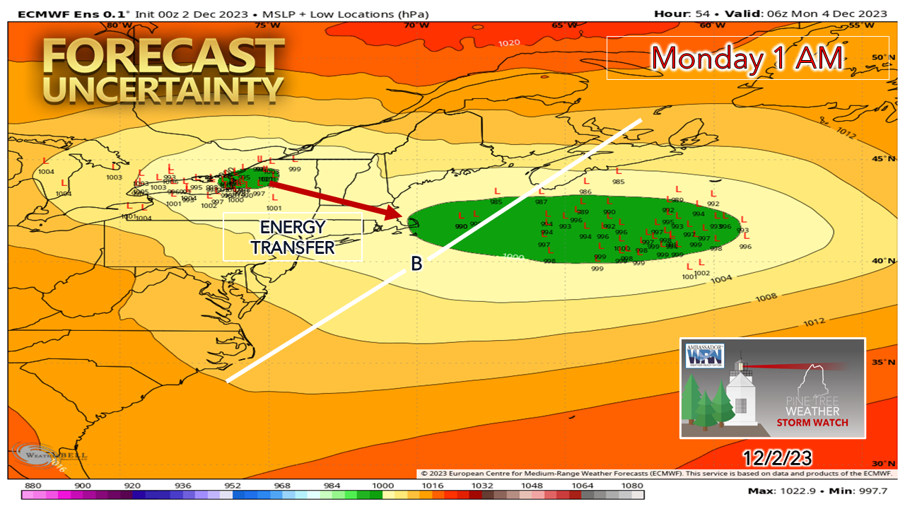
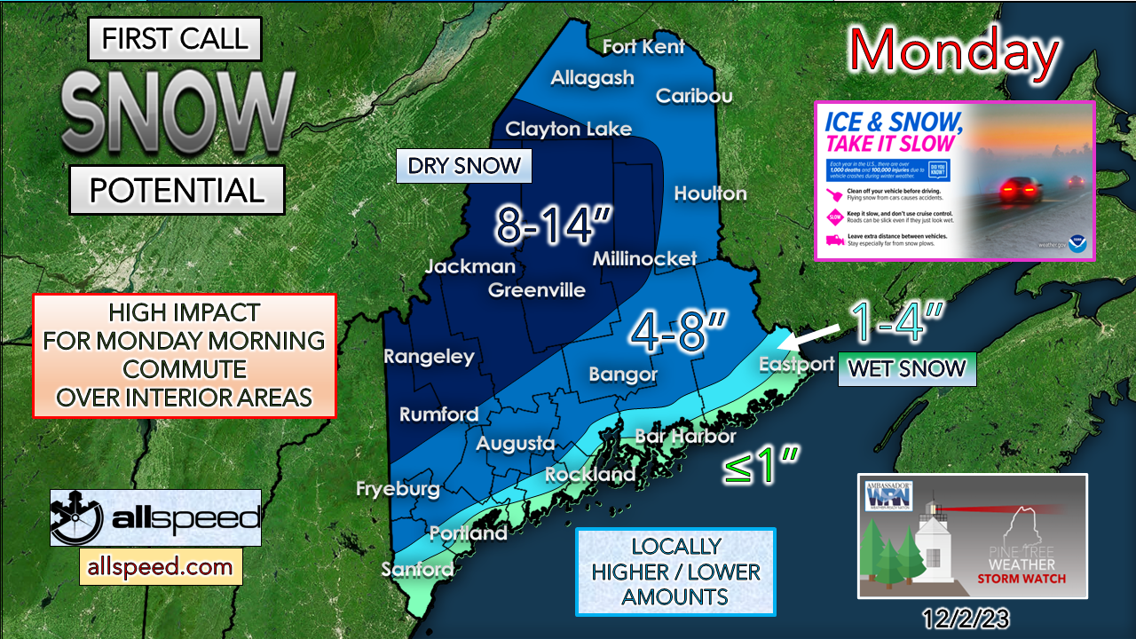
Light snow for the north on Saturday

Picture
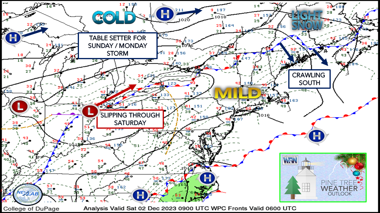
The 1 AM surface map shows the boundary that is splitting the state, and it doesn't appear that it is going very far. It will be cooler in the north where the thermometer won't move upwards much during the day. Areas south of the front enjoy another mild day, but not quite as warm as Friday.

A weak area of low pressure passes through the slipstream between the areas of high pressure in the north and south. That will help nudge the stalled front to the south Saturday night and bring the cold in ahead of the storm on the way Sunday into Monday.​
Picture
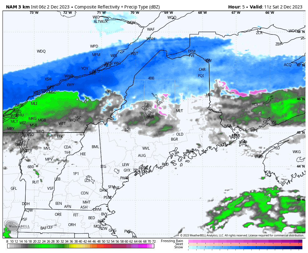
Saturday 6 AM to 7 PM - Outflow ahead of the weak low brings areas of light snow over the north where 1-3" of accumulation is possible there. To the south, a light rain shower or sprinkle is possible, with a glimpse of sun poking through at times. Highs for the day range in the 30s north to 40s south, perhaps 50° if the sun stays out long enough in spots, and wind is expected to be light for most areas. 

Cooler air filters in overnight, dropping temperatures in the north into the 20s, and 30s elsewhere. 

A decent snow on the way Sunday into Monday
​for the interior

Picture
Guidance is coming to better agreement on how this is going to play out. This is a flat set up, with not much in the way of wind and dramatic drop in barometric pressure. While optically it appears lazy, moisture from the southwest will help add the juice it needs to bring a solid round of snowfall for areas away from the shorelines. 

While the interior is set to get snow, accumulations closer to the coast become more of a challenge. 
Picture
Given the passive set up, ground temperatures come into play. Most of the coast is flirting around freezing, with temperatures above freezing closest to the shores. This is where the greatest bust potential exists.
Picture
Sunday 4 AM to Monday 7 PM - Cold air from high pressure to the north is what will keep interior areas snowy.  The cold air damming signatures are there. Precipitation may be light in spots Sunday morning, but it will begin to become more widespread in the afternoon and evening. Monday morning is going to be a mess. Conditions will begin to improve for most on Monday as the storm pulls way, ending in the morning over southwestern areas and by afternoon over the north.  The wind begins to pick up as the energy from the low to the northwest transfers energy to the ocean low, and that picks up the snow shower machine for the mountains heading into Monday night. 
Picture
This could be a situation where the shorelines could see 35° air temperature and snow falling given the low level cold. The shorelines and adjacent interior could see rain to start off and flip to snow to end. 

Picture

Please make my 2 AM wake up calls worth it
​and help me pay the bills

Picture
If you like what I do, please pass along what I do.

Stay updated, stay on alert, and stay safe!

- Mike

​NOTE: The forecast information depicted on this platform is for general information purposes only for the public and is not designed or intended for commercial use. For those seeking pinpoint weather information for business operations, you should use a private sector source. For information about where to find commercial forecasters to assist your business, please message me and I will be happy to help you.

Comments
    Picture

    Mike Haggett
    Kennebunk, ME

    Weather-Ready Nation
    Ambassador

    Certified Weather
    Forecaster
    Penn State '21

    American Meteorological Society

    National Weather Association
    ​
    ​SKYWARN-CWOP

    Matthew 19:26


    DONATE

    Picture
    Picture
    Picture
    Picture
    Picture

    Picture

    Picture

    Picture

    Picture

    Picture

    Picture

    Picture

    Picture

    Picture

    Picture

    Picture

    Picture


    Archives

    April 2025
    March 2025
    February 2025
    January 2025
    December 2024
    November 2024
    October 2024
    September 2024
    August 2024
    July 2024
    June 2024
    May 2024
    April 2024
    March 2024
    February 2024
    January 2024
    December 2023
    November 2023
    October 2023
    September 2023
    August 2023
    July 2023
    June 2023
    May 2023
    April 2023
    March 2023
    February 2023
    January 2023
    December 2022
    November 2022
    October 2022
    September 2022
    August 2022
    July 2022
    June 2022
    May 2022
    April 2022
    March 2022
    February 2022
    January 2022
    December 2021
    November 2021
    October 2021
    September 2021
    August 2021
    July 2021
    June 2021
    May 2021
    April 2021
    March 2021
    February 2021
    January 2021
    December 2020
    November 2020
    October 2020
    September 2020
    August 2020
    July 2020
    June 2020
    May 2020
    April 2020
    March 2020
    February 2020
    January 2020
    December 2019
    November 2019
    October 2019
    September 2019
    August 2019
    July 2019
    June 2019
    May 2019
    April 2019
    March 2019
    February 2019
    January 2019
    December 2018
    November 2018
    October 2018
    September 2018
    August 2018
    July 2018
    June 2018
    May 2018
    April 2018
    March 2018
    February 2018
    January 2018
    December 2017
    November 2017
    October 2017

Proudly powered by Weebly