|
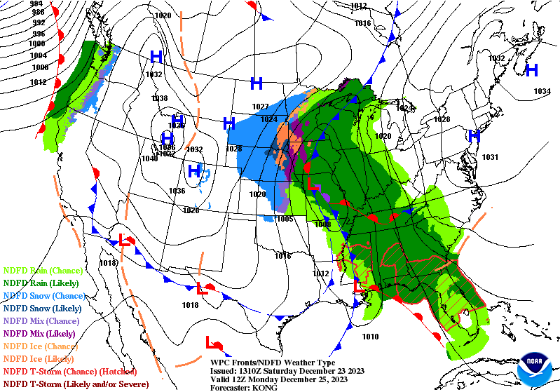
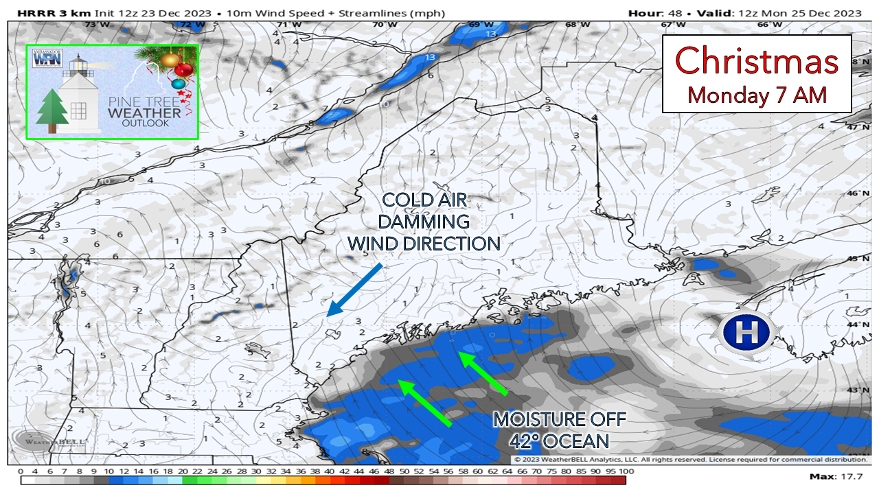
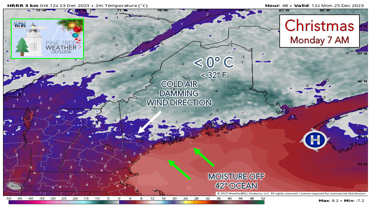
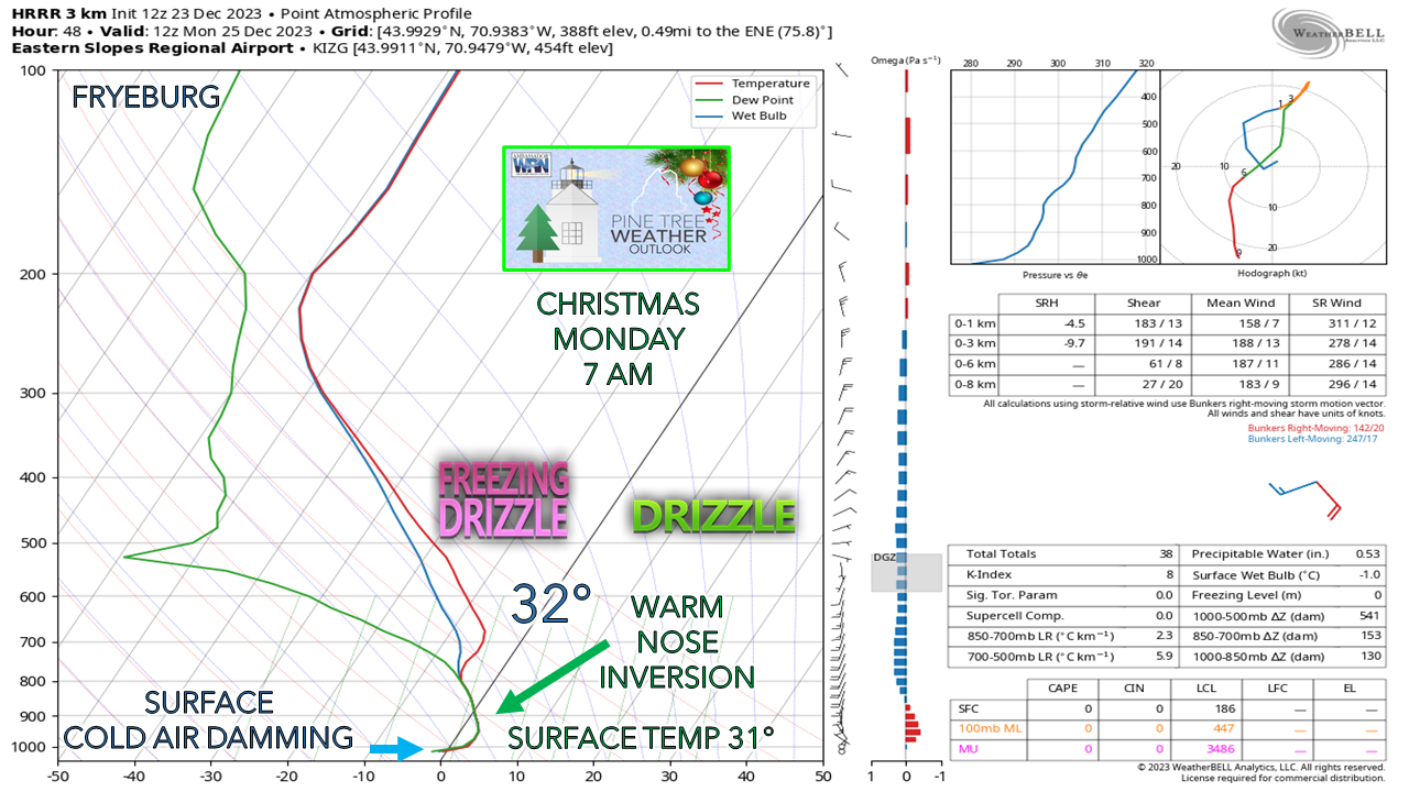
Cold air damming. Warm noses. Low level inversions. These are all common meteorological terms that I use quite frequently in winter. I talk about them when it comes to mixed precipitation events (sleet, freezing rain) where I use the slang "junk" or "junk storms" because the results of them are slippery conditions with trashy outcomes, not to mention the fact they can be a real challenge to predict. Sometimes I call them PITA storms. For the definition of that, I'd suggest you look up the acronym with the Urban Dictionary. Models often miss cold air damming. This is a known issue that has improved a bit over the twelve years I have monitored and predicted weather. Models tend to run warm, which is a natural bias. Since cold air is more dense due to slower molecular movement, it has made models, smartphone apps, and forecasters look like fools. In the spirit of transparency, I've been burned more times with busted forecasts by this in the past that I care to admit. I have learned to respect the cold for what it is, what to look for, and where to find hints of it. With southwest areas of the state have the risk of light ice for Christmas morning, and since I have time to explore this a bit more in depth, I am going to dive into it. The set upWPC Forecast Monday 7 AM - It looks innocent enough. High pressure situated near the nose of Nova Scotia. Since the high is to the east, one can easily think the clockwise motion of the high would bring warm air in off the water, which it does. This is where clouds and potential for light precipitation come into the forecast. Given the fact the high is strong as indicated by the isobars (black lines) it's a slow mover, and doing a great job causing a messy holiday over the Midwest with wet conditions from Florida northward into Ontario. That is headed our way midweek, but I'll leave that alone for now. The high is polar in nature given the cold that it carries with it. It doesn't appear to be a big deal for us in Maine. But then there is that other high to the south near New York City, just hanging out. Between the two highs is where a bit of concern comes in, and that is southwestern areas of the state. The diagnosis of cold air dammingThe first clue of potential cold air damming is two fold. The first is wind speed, the second is wind direction. There isn't a whole lot of wind over the interior, which is the first tip off. The second is the direction that the wind is coming from. This model idea of the HRRR shows the flow over the northeast. The surface high near Nova Scotia is showing some agitation from the high to the south and the mess going on to the west. This is kicking the breeze up over the Gulf of Maine. The southwest flow brings moisture in off the water. There is a good chance most areas wake up to a cloudy sky, with the exception of northern areas, and perhaps Washington County. The southwest flow off the ocean is throwing warm air on top of cold air. Using the temperature predicted by the HRRR model in Celsius to best show the difference between freezing (gray) and above freezing (blue, red), taking the model idea at face value would make the initial assumption that the southwest flow would wash out the cold over the southern part of the state. Sometimes I refer to models as shady used car salesmen. The wind direction trumps what models think of 2 meter air temperature when cold air is around in most cases. Needless to say, I am not buying what the model is selling. Going a level deeper here, I look at what is known as SKEW-T diagrams. These are complicated. I spent three weeks in a pseudo-boot camp with these while studying weather forecasting through Penn State during COVID. They are called SKEW-T's for a reason, because they are a skewed look at the atmosphere. These replicate data that is generated from radiosondes (weather balloons) that go up in the sky at 00z (7 PM EST) and 12z (7 AM EST) daily around the world. Long time followers see me pull these out at times to make a point, usually for junk storms or in severe thunderstorm situations. I am going to dumb these down a bit to show the basics, and the fine line that cause hairs to split with forecasting. As you will see with the forecast for Christmas morning. it's tight. The focal point here is Fryeburg as a forecast point, but looking around at other locations (Lewiston, Sanford, Kennebunk, Portland) they all ring a similar theme. The NAM3km model here. What is noted is the warm air being shoved in aloft from the high of the nose of Nova Scotia. This is sets up a warm air inversion where precipitation that is generated at the low level (the combination of the three squiggly lines of dew point [green], wet bulb [blue], and air temperature [red]) rises above freezing before reaching the surface. This leaves the impression that there is potential for freezing drizzle, but shows also the potential for a bit of dry air, likely enough to dispel the theory of precipitation as the lines deviate at the surface. Cold air damming is showing itself on the surface as the warm nose inversion is cut off at the point of contact on the ground floor. The HRRR model here shows some subtle differences, most notably a more defined precipitation stream with the squiggly lines tighter together. It also shows the warm nose, and a cooler surface temperature, which indicates the potential for freezing drizzle and/or rain on 7 AM Christmas Day. While the risk for ice is a slight one for Christmas morning, the idea is out there. This is not a significant event, but it's doesn't take much ice on untreated surfaces to spoil holiday plans, whether by vehicle or on foot. Why is understanding cold air damming important?When precipitation is falling in liquid form with cold air damming around, it's a recipe for ice. While your vehicle thermometer may tell you the temperature is above freezing, it can give drivers the false impression that the surface is the same. For safety sake, bet that it isn't. I've worked in the commercial vehicle parts industry for nearly 25 years. I've seen many a wrecked vehicle hauled in on a hook. This time of year, the common cause is ice. Vehicle thermometers can be off as much as 5° from the actual surface temperature. I've mentioned this in the past and its worthy to remind followers again that any thermometer reading 37° or less - whether vehicle or home outdoor thermometer - could potentially mean a surface temperature at or below freezing. Ice is the most common cause of hospitalization from vehicle accidents and personal injury from falls in Maine in the winter. Think of cold air like a drunk uncle that has outstayed his welcome, who can become belligerent, and has the keys to the liquor cabinet. It does what it pleases when it wants to. Your app may say the temperature is above freezing, or when it will be above freezing, and be completely wrong. It can never be trusted to leave on time, which in some cases messes with travel. It can appear to extend icing events when liquid is falling from the sky. You can bet that with frozen ground and eventually snow on the way that it will be more problematic at times. That is the way winter works here in Maine. The cold always has the last word on precipitation outcome and forecast temperature change, every time. The mission continues because of youThank you to Allspeed Cyclery & Snow in Portland, Downeast Aerial Photography in Rockland, Dutch Elm Golf Club in Arundel, and Sunrise Property Services in Bridgton, for partnering with Pine Tree Weather. Special thanks to all the individuals who financially contribute. I sincerely appreciate your support. Stay updated, stay on alert, and stay safe! - Mike PRINT MEDIA: Feel free to quote and cite my work here for your stories. Please give me the professional courtesy of knowing that you are referencing my material so I can read your final product and acknowledge it on my media and link it on the Who I Am page here on the website. Feel free to send me a message via the Facebook page or Twitter (X) to get my phone number if necessary. Thank you! NOTE: The forecast information depicted on this platform is for general information purposes only for the public and is not designed or intended for commercial use. For those seeking pinpoint weather information for business operations, you should use a private sector source. For information about where to find commercial forecasters to assist your business, please message me and I will be happy to help you. |
Mike Haggett
|

