Pine Tree Weather
  • DISCUSSIONS
  • Substack
  • WEATHER WALL
  • MARINE
  • CPC OUTLOOK
  • Kennebunk
  • INTERNSHIPS
  • MY BIO
  • PTW IN MEDIA
  • INTERN ALUMNI
  • DISCUSSIONS
  • Substack
  • WEATHER WALL
  • MARINE
  • CPC OUTLOOK
  • Kennebunk
  • INTERNSHIPS
  • MY BIO
  • PTW IN MEDIA
  • INTERN ALUMNI

Saturday December 9, 2023

12/9/2023

Comments


Watches posted

Picture
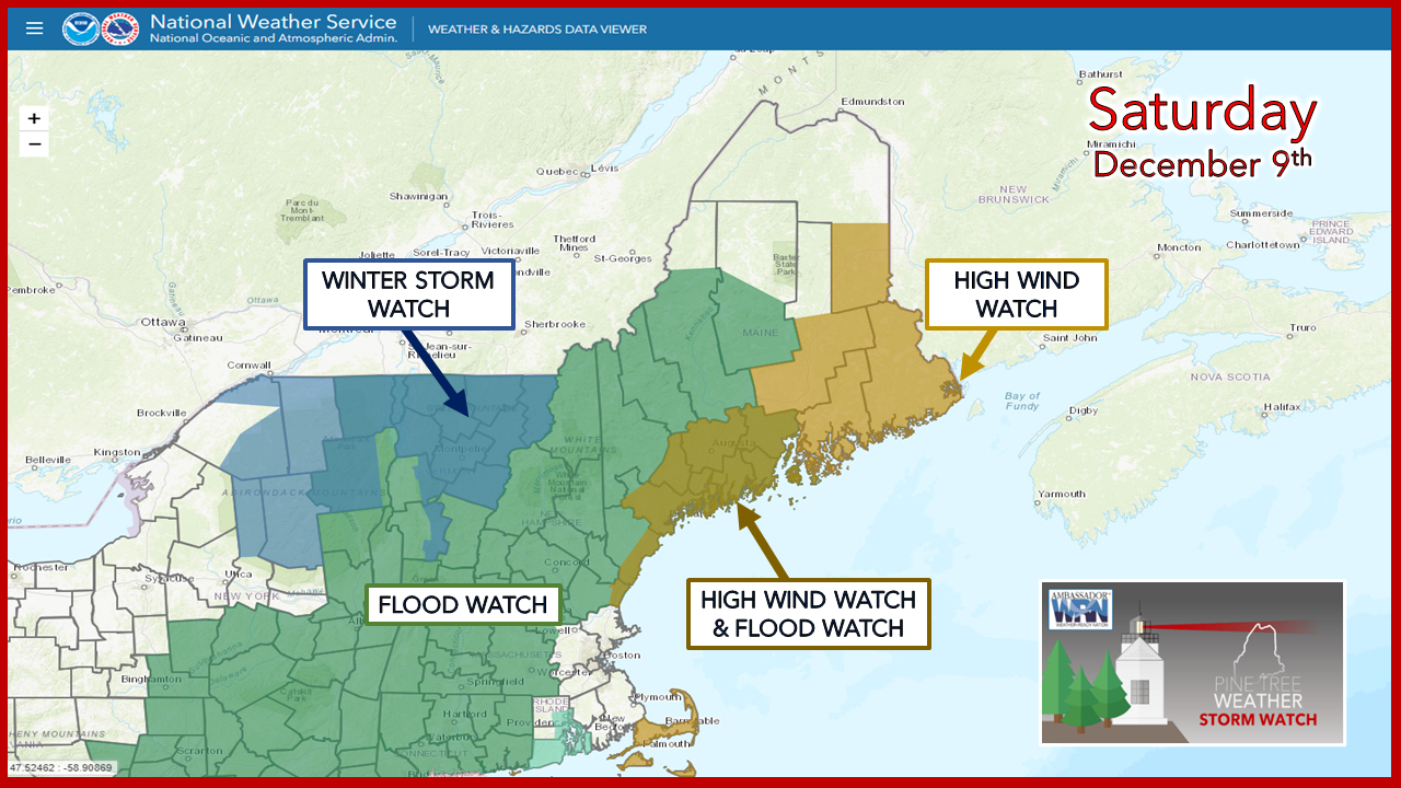
This storm is shaping up to be a mess.  One thing that has not been issued yet are coastal flood statements, and those will come when the window opens. For those not under a flood watch in  northern and eastern areas should stay tuned. 

A sloppy wet smacker

Picture
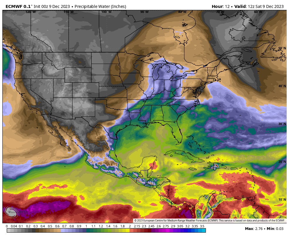
A look here at precipitable water shows the set up. Trough over the region early Saturday gets shoved out, a strong ridge surges in from the southwest into Sunday, with a deep trough driving the ridge out on Monday. There is plenty of moisture from the Gulf of Mexico with this system. Fortunately, it will be a quick mover.

Temperatures climb into Sunday then crash on Monday

Picture
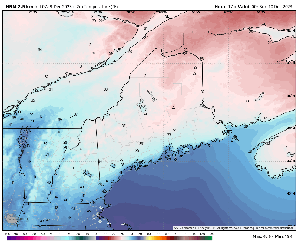
Loop here of temperatures from 7 PM Sunday to 7 AM Tuesday shows the roller coaster ride. All areas climb above freezing to clean up whatever snow may be on trees. There could be some areas of fog, which could be locally dense, which will ripen snow. All of this happens before the wind arrives in the wee hours of Monday.  

As the front passes through on Monday, temperatures fall quickly behind it. With the amount of precipitation on the way, there are likely to be a freeze up of puddles and standing water, which creates black ice potential heading into Tuesday. 

The wind chill Tuesday morning is likely to provide the final slap in the face from this storm.  Expected apparent temperatures a few degrees +/- 0° in the mountains and teens for the coast.

Precipitation and wind

Picture
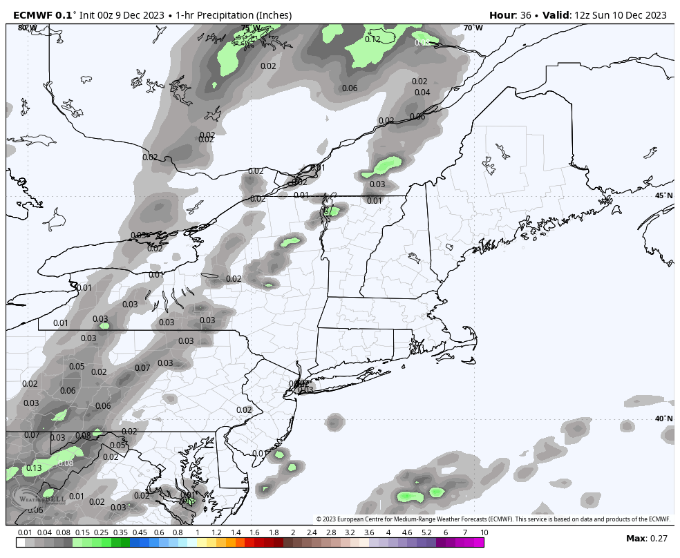
Sunday 7 AM to Monday 7 PM - Sunday appears to start off mainly dry. Showers may flare up over the mountains in the morning, and expand into the rest of the region in the afternoon. Areas of light to moderate rainfall and areas of patchy drizzle and fog is the theme into Sunday night. As low pressure intensifies on the frontal boundary, areas of moderate to heavy rain form Monday morning as the low-level jet arrives. As the front sweeps through, precipitation ends from west to east in the afternoon and is over for most areas by Monday evening. 

A general 1-3" of rain is expected statewide. There is some uncertainty about how dynamic cooling may play a role in a change over to a mix/snow in the western mountains. There are ideas out there where it could happen in time for some accumulation of pasty wet snow, and may be enough for power outage concerns. Folks in those areas should stay tuned on that. 
Picture
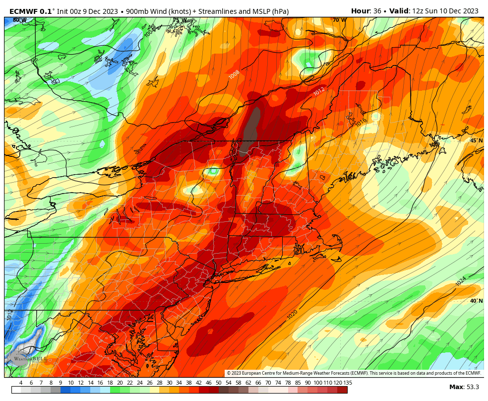
Sunday 7 AM to Monday 7 PM - This is a loop of the low-level jet at roughly 2,000 feet. This highlights the areas under a high wind watch well. Speeds of 70-90 knots (80-100 mph) have been the consistent theme. That translates into potential for 50-70 mph wind gusts at the surface. 

​The model trend here over the past couple of days has been a bit more to the east. If this idea holds serve, this may shorten the threat for wind damage over the west and south. MidCoast and DownEast areas are likely to get hit the hardest, with the brunt coming in ahead of the front during the morning on Monday. By early afternoon, the threat drops over eastern areas. A northwest wind flow develops on the back side which brings the cold air in with gusts in the 20-30 mph range through the rest of the day and into Tuesday. 

Shoreline areas to be impacted, especially DownEast

Picture
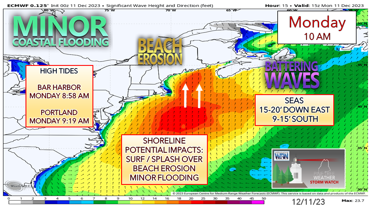
The idea of a shoreline battering continues. With the timing of the strong wind gusts moved ahead a bit, that may help to minimize impacts somewhat over the southwest coast. MidCoast and DownEast areas see the higher surf and the most impacts. With the Monday morning high tide running 1-1½ feet above normal with the astronomical influence along with the surf, there is shoreline flood potential. 

Stay tuned for more fine tuning of the forecast. 

​Please make my 2 AM wake up calls worth it
​and help me pay the bills

Picture

Thank you to Allspeed Cyclery & Snow in Portland, Downeast Aerial Photography in Rockland, Dutch Elm Golf Club in Arundel,
and Sunrise Property Services in Bridgton, for partnering with Pine Tree Weather.

Special thanks to all the individuals who financially contribute.
​I sincerely appreciate your support. 


Stay updated, stay on alert, and stay safe!

- Mike

PRINT MEDIA: Feel free to quote and cite my work here for your stories. Please give me the professional courtesy of knowing that you are referencing my material so I can read your final product and acknowledge it on my media and link it on the Who I Am page here on the website. Feel free to send me a message via the Facebook page or Twitter (X) to get my phone number if necessary. Thank you!  ​

​NOTE: The forecast information depicted on this platform is for general information purposes only for the public and is not designed or intended for commercial use. For those seeking pinpoint weather information for business operations, you should use a private sector source. For information about where to find commercial forecasters to assist your business, please message me and I will be happy to help you.

Comments
    Picture

    Mike Haggett
    Kennebunk, ME

    Weather-Ready Nation
    Ambassador

    Certified Weather
    Forecaster
    Penn State '21

    American Meteorological Society

    National Weather Association
    ​
    ​SKYWARN-CWOP

    Matthew 19:26


    DONATE

    Picture
    Picture
    Picture
    Picture
    Picture
    Picture

    Picture

    Picture

    Picture

    Picture

    Picture

    Picture

    Picture

    Picture

    Picture

    Picture

    Picture

    Picture


    Archives

    January 2026
    December 2025
    November 2025
    October 2025
    September 2025
    August 2025
    July 2025
    June 2025
    May 2025
    April 2025
    March 2025
    February 2025
    January 2025
    December 2024
    November 2024
    October 2024
    September 2024
    August 2024
    July 2024
    June 2024
    May 2024
    April 2024
    March 2024
    February 2024
    January 2024
    December 2023
    November 2023
    October 2023
    September 2023
    August 2023
    July 2023
    June 2023
    May 2023
    April 2023
    March 2023
    February 2023
    January 2023
    December 2022
    November 2022
    October 2022
    September 2022
    August 2022
    July 2022
    June 2022
    May 2022
    April 2022
    March 2022
    February 2022
    January 2022
    December 2021
    November 2021
    October 2021
    September 2021
    August 2021
    July 2021
    June 2021
    May 2021
    April 2021
    March 2021
    February 2021
    January 2021
    December 2020
    November 2020
    October 2020
    September 2020
    August 2020
    July 2020
    June 2020
    May 2020
    April 2020
    March 2020
    February 2020
    January 2020
    December 2019
    November 2019
    October 2019
    September 2019
    August 2019
    July 2019
    June 2019
    May 2019
    April 2019
    March 2019
    February 2019
    January 2019
    December 2018
    November 2018
    October 2018
    September 2018
    August 2018
    July 2018
    June 2018
    May 2018
    April 2018
    March 2018
    February 2018
    January 2018
    December 2017
    November 2017
    October 2017

Proudly powered by Weebly