
The big picture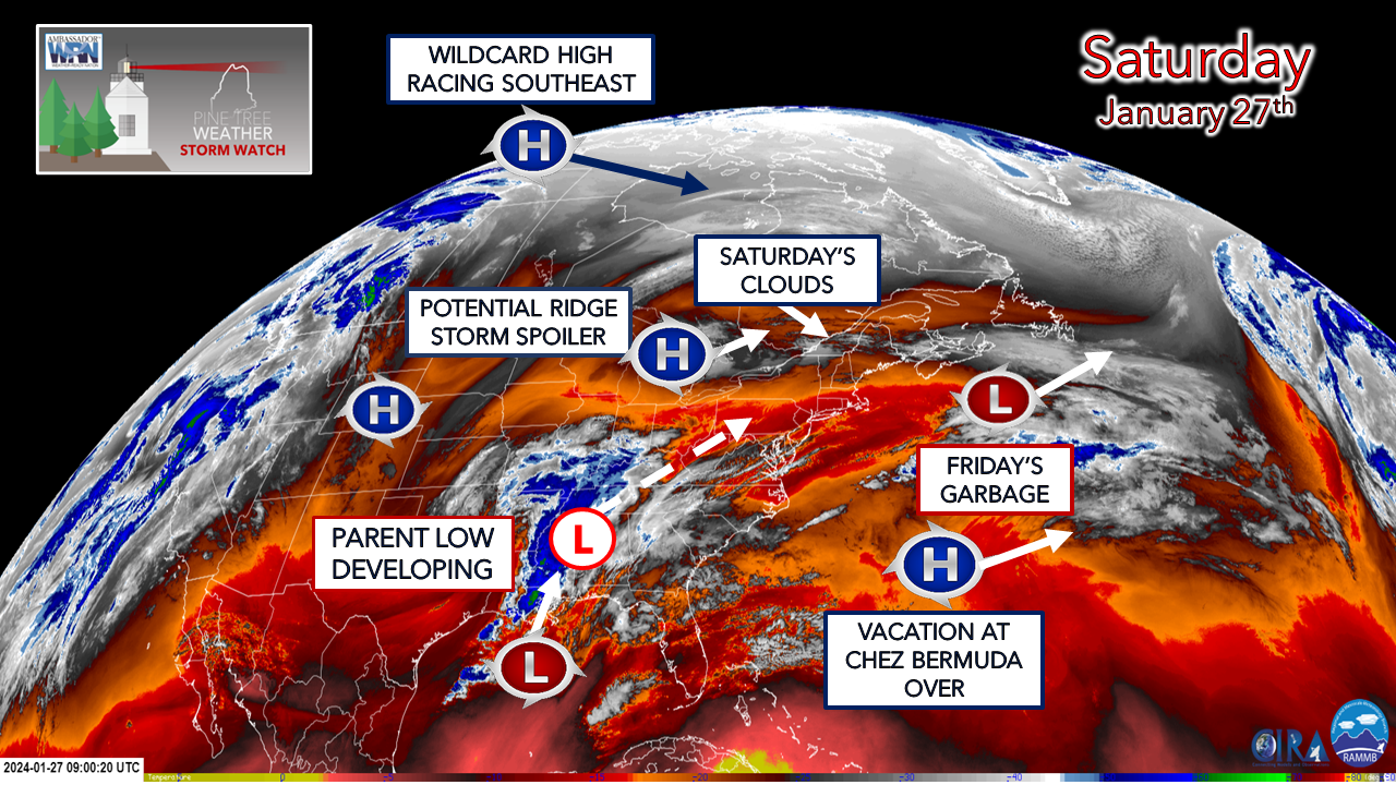 Hopefully folks were able to clean up from Friday's trash. I suspect the salting of roadways and sidewalks will be a thing through Saturday morning, with potential for a touch up run later in the day as what melting occurs freezes up again heading into Saturday night. Coastal areas may not see much in the way of sun, but diurnal heating should get temperatures into the mid to upper 30s for the south. Temperatures range from the low to mid-30s south of the mountains on a line to Greenville, Millinocket to Danforth, with areas to north below the freezing point for the day. The wildcard high holds the ace in the hole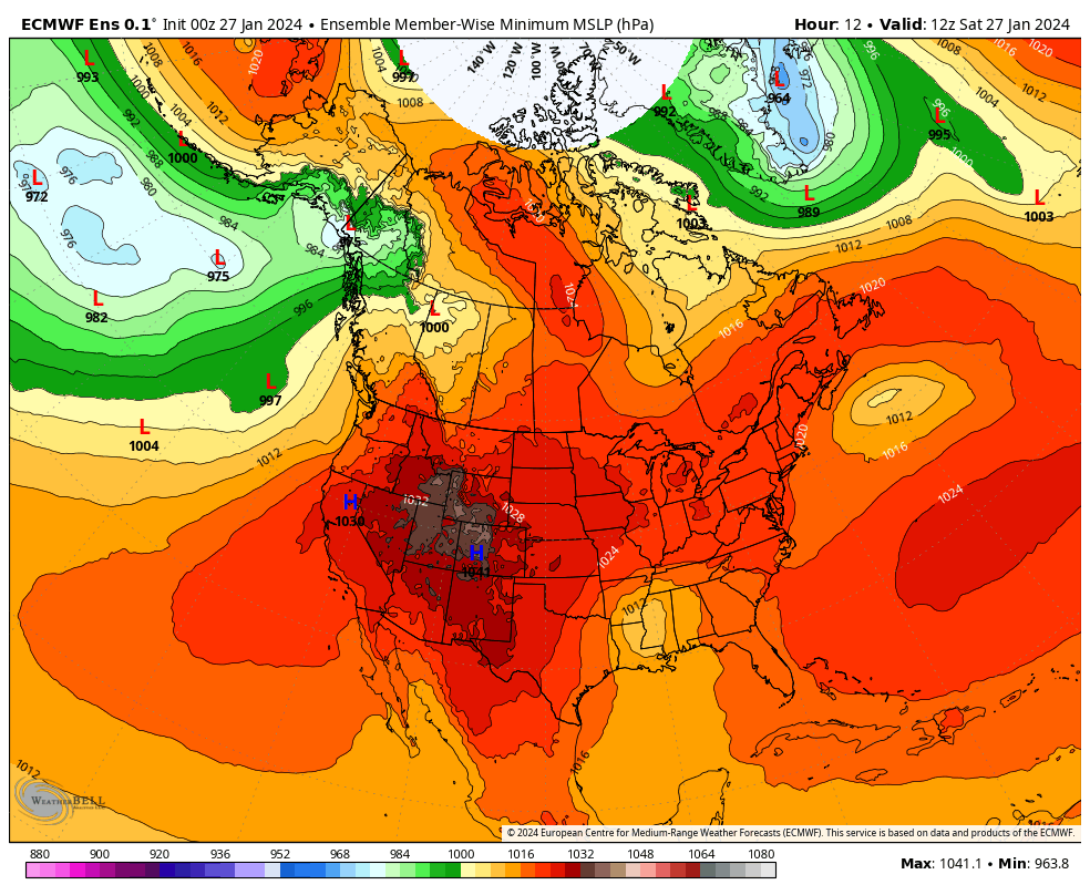 Saturday 7 AM (12z) to Monday 7 PM (00z Tuesday) - I have not been a fan of this set up all week and I continue not to be one. Guidance is still rather scattered in ideas and I can't shake the dry signal out of my mind. As you watch this loop, look at where the wildcard high is coming in from over the Northwest Territories. That is a very poor area for atmospheric sampling by weather balloons since the release stations are minimal. Guidance is compensating for that by depending on satellite and ground observations which can be off as much as 20%. That 20% may not sound like much, but with Maine on the fringe of this storm, that means there is plenty of wiggle room left to affect the outcome. As as result of the way models are rigged, there are eye opening discrepancies within 36 hours to the start of the event. 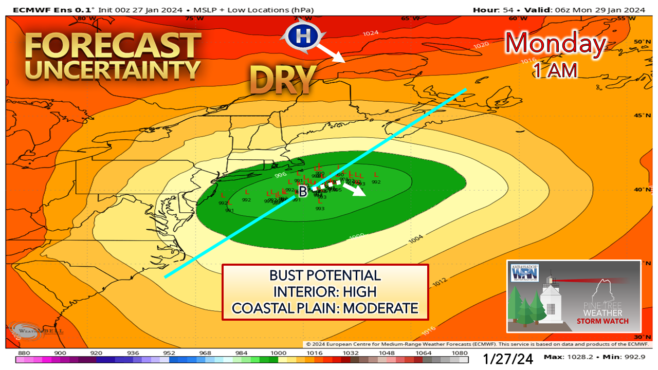 I've said all along with this storm that dry air will tell the tale for the interior. York County will get the most out of this. It's not an impressive "York County Special" like some we've seen, and is unlike the one earlier in the month. With the track around the benchmark 40°N / 70° W point, with a potential jog to the southeast as the wildcard high screams in to cut the storm off, and a weak ridge jammed in the middle of that sandwich, this is where bust potential is high for the interior, and fair to say DownEast areas as well given the forecast track. All of this fuss over a couple inches of snow. There is nothing like living on the edge. The idea as of Saturday morning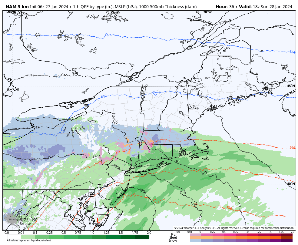 Sunday 1 PM (18z) to Monday 1 PM (18z) - Precipitation begins over York County late afternoon on Sunday then heads north and east in the overnight. The overnight into Monday morning travel is likely to be a slick one for the populated coastal plain areas, and perhaps Bangor. What I like about the model idea is it captures the dry air better than most I have seen. What I don't like about it is the jumpy forecast track that brings the low inside the benchmark point. Any jog to the northwest toward Cape Cod means there is potential for a coastal front to work in, aided by the 40° ocean temperature. That means potential for warm noses that could bring sleet and freezing rain, or rain. If that were to occur, that spoils snowfall for the shoreline communities. Snow is expected to end from northwest to southeast in the afternoon. I'll have a better idea on this Sunday morning. 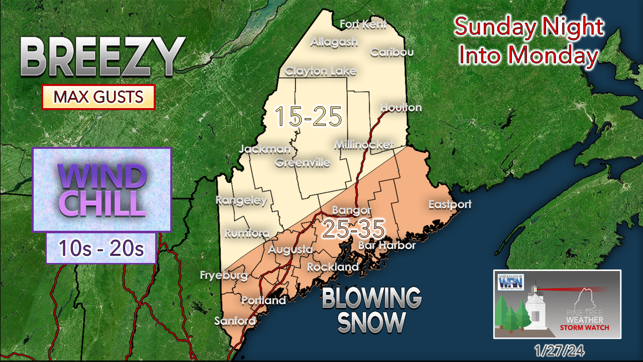 This storm is a NorEaster which means it is likely to be a breezy one. Snow will blow around which may cause some brief whiteout conditions, especially over the south. The wind will be gustier along the shorelines and the islands. With the ridge in between the storm and high pressure to the north, the region is unlikely to experience backside northwest winds as the storm departs. 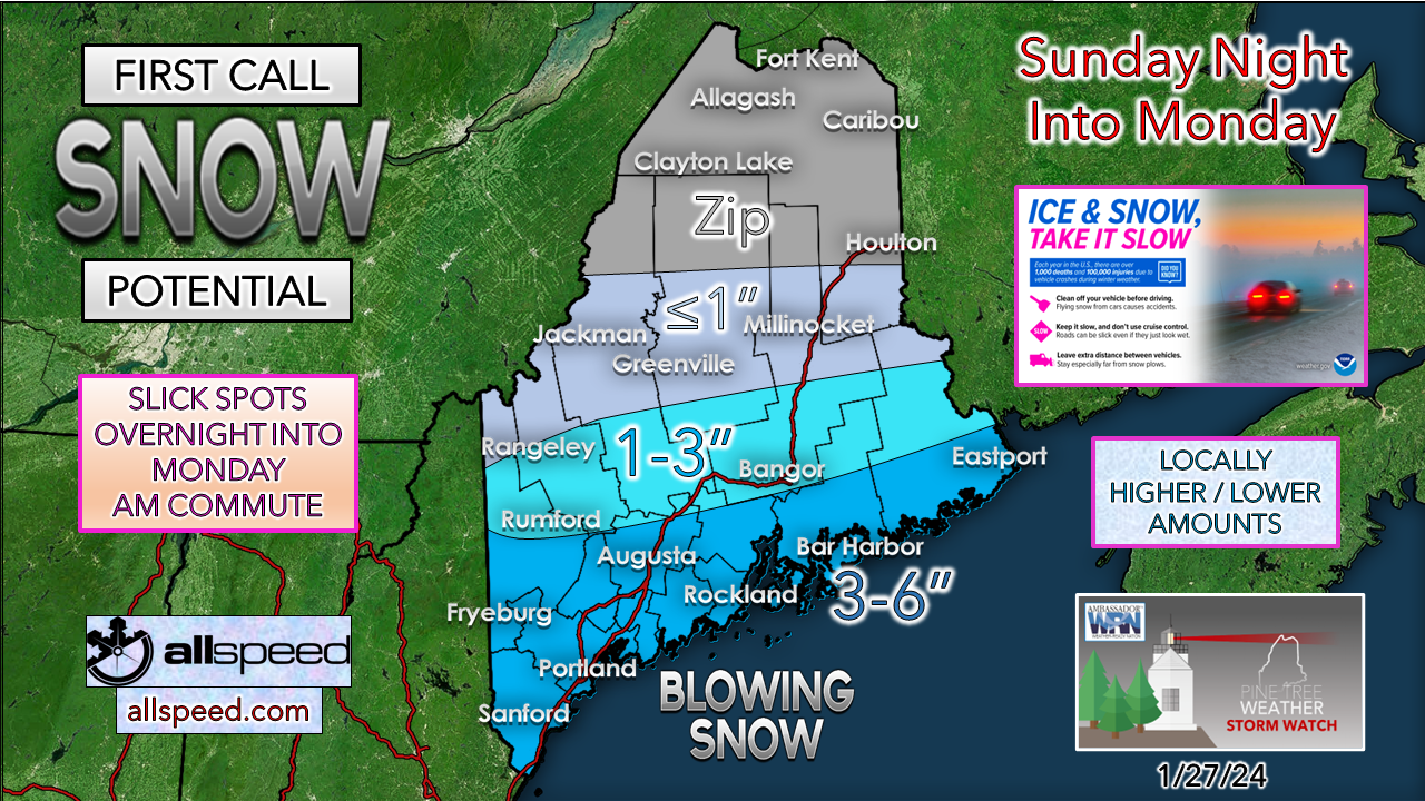 A winter storm watch is posted for southern New Hampshire, including Rockingham County as there is enough confidence there for a 6"+ snowfall. There is no question York County gets the high end snowfall amounts with this system. Folks in the Sanford / Lebanon / Acton area have a fair chance to get to 6". Again, bust potential is there to the north and east. I will update on this Sunday morning. Where else are you going to find this type of information? Thank you to Allspeed Cyclery & Snow in Portland, Downeast Aerial Photography in Rockland, Dutch Elm Golf Club in Arundel, and Sunrise Property Services in Bridgton, for partnering with Pine Tree Weather. Special thanks to all the individuals and businesses who financially contribute. I sincerely appreciate your support. Always have MULTIPLE ways to receive weather alerts. Stay updated, stay on alert, and stay safe! - Mike PRINT MEDIA: Feel free to quote and cite my work here for your stories. Please give me the professional courtesy of knowing that you are referencing my material so I can read your final product and acknowledge it on my media and link it on the PTW IN MEDIA page here on the website. Feel free to send me a message via the Facebook page or Twitter (X) to get my phone number if necessary. Thank you! NOTE: The forecast information depicted on this platform is for general information purposes only for the public and is not designed or intended for commercial use. For those seeking pinpoint weather information for business operations, you should use a private sector source. For information about where to find commercial forecasters to assist your business, please message me and I will be happy to help you. |

Mike Haggett
|


