
|
I want to say thank you to all who have chipped in to help keep this boat afloat for the year ahead. I am 68% funded for 2024, which means I am short about $1000. Any amount you can spare would be greatly appreciated. You can click on the banner at the end of the post to the donate page which gives you options. Thank you! A funny thing is going on with El Niño...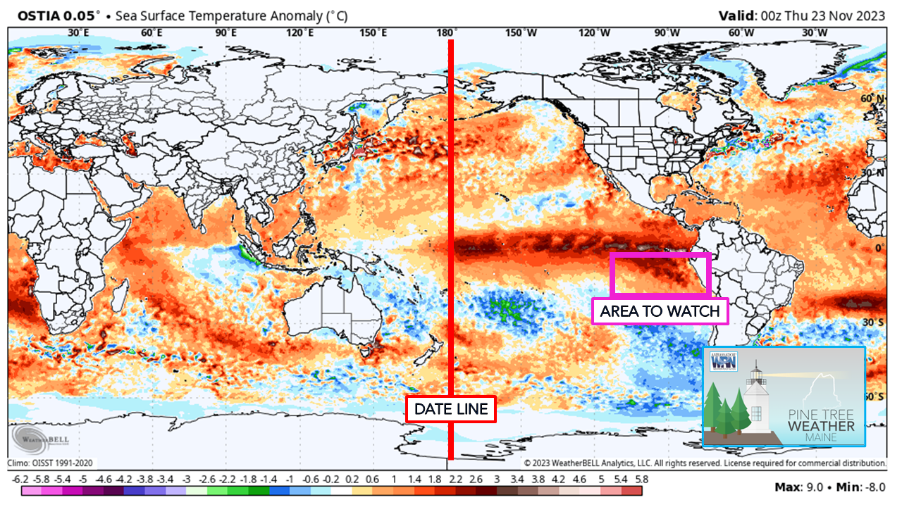 I've been noticing where this El Niño isn't behaving quite the way the seasonal outlooks back in September and October. We're running colder here than the ideas that have been tossed around. I've added the international date line in here as that is an indicator of a "super" El Niño. When the above normal temps cross that point, it's game on for a strong one. It's close, but not alarming in my view. To the average person, it looks healthy and impactful. The cold pool to the south on the eastern side of the date line has grown from my previous discussion on this, but the north Pacific remains warm, but subtly cooling down from earlier in the month. Looking at anomalies is tough to see any significant changes unless one has a keen eye. The subtle cooling in the north and growth of the cold pool to the south was pretty easy for me to pick up on. The surprise comes with what is going on in the east offshore of Ecuador and Peru. It has lightened up a bit, but I did not notice how much until I did more digging. It looks rather strong. 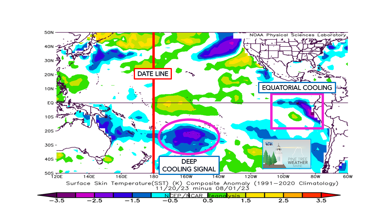 Since the first of August, that area has cooled down, while the area to the west near the date line has warmed. The cold pool to the south has grown, but that is to be expected in an El Niño period. As I mentioned previously this month, El Niño's usually have cold pools to the north and south. With cooling in the east and warmth holding over the central Pacific, this sets up what is known as an El Niño Modoki. We had one back in the winter of 2014-15. It was the snowiest and coolest winter we've had in several years. For those stratospheric warming geeks that follow me, note that one occurred in early January that year, and that is when the cold unloaded. There is a strong hint that a stratospheric warming event may happen in early December. If that happens, it could be a long, cold, and snowy winter. The other wrench in this is the volcanic activity going on in Iceland. All of it plays a role in how winter evolves. I am no long-term forecasting swami who sits in the corner on a pillow surrounded by candles rubbing a genie pot while hauling on a hookah with the magic herb, so take this for what it is worth. Just be aware that there is potential for more winter than was initially advertised. Monday still looks wet for most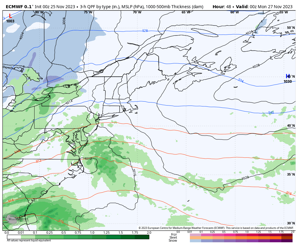 Sunday 7 PM to Tuesday 7 AM - Be aware there is still some uncertainty on track, so there could be some changes still to come. Models are handling the kicker energy cutting across western Canada differently and it turns into a timing game as to when it comes together with the sub-tropical jet. We do have a bombogenesis situation with the ocean low rapidly intensifying as it spins through the Gulf of Maine. I think the Euro has the better idea of handling arctic injection. Rain for the coast, snow to rain and a flip back to snow over the interior is a fair assumption, with the risk of a sprinkling of sleet & freezing rain is possible. The Monday morning commute could be a bit of challenge everywhere across the state, whether it is wet sloppy snow, steady to moderate rain, some fog, and reduced visibility. Conditions improve later in the day into Monday night. 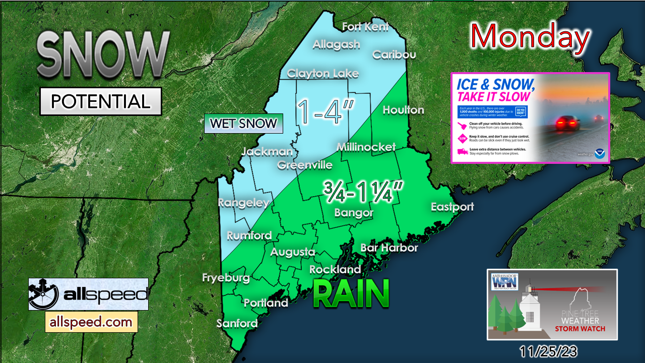 This is a forecasting headache for snow amounts with the flip flopping that is possible. Higher elevations stay snow longer. For the rest of the area, it will be easy to shovel.  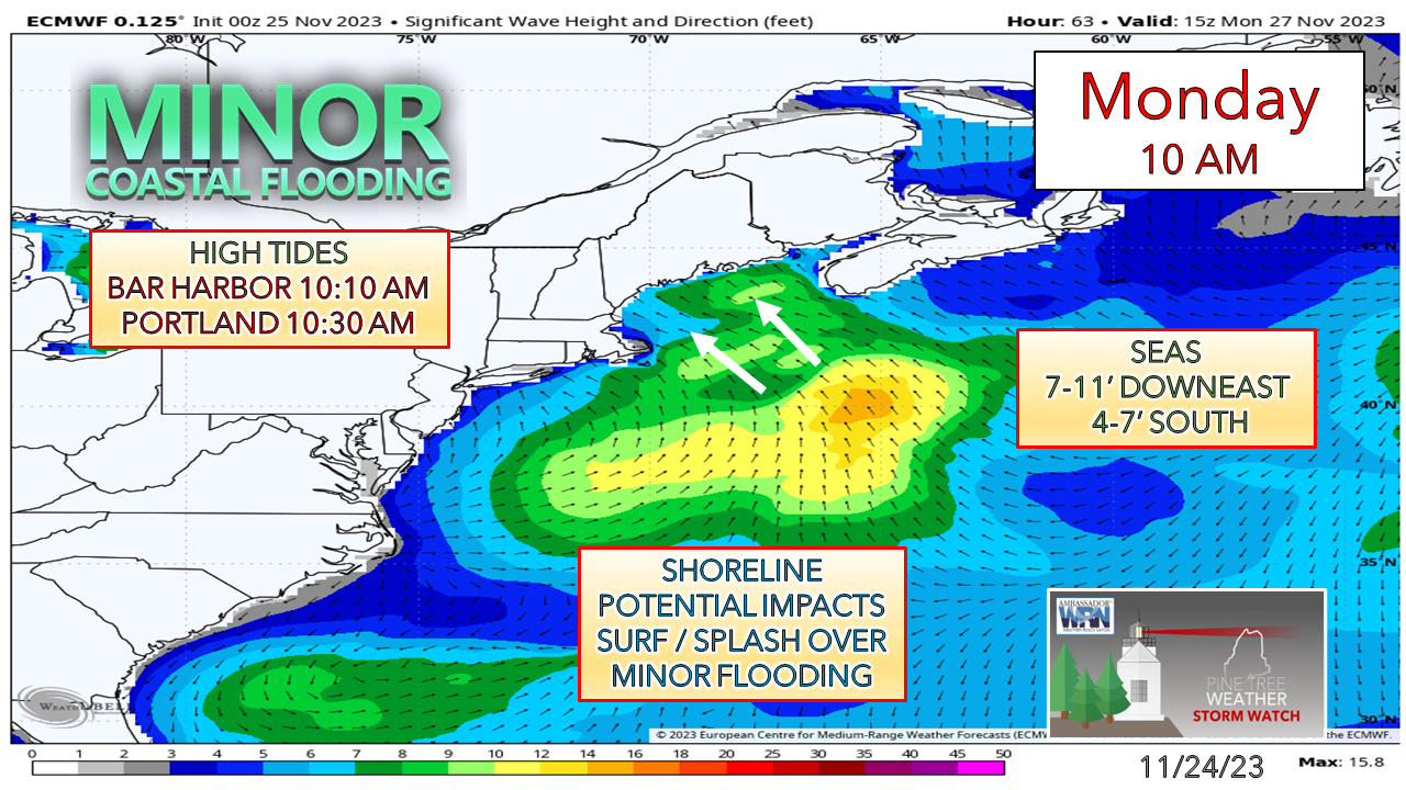 Some minor coastal concerns with this one as the southeast wind shoves water onshore during the morning high tide, and there could be a bit of surge. The tides are running astronomically high with the full moon on Monday. Portland is expected to run just short of 11' and Bar Harbor just over 12'. Throw this storm into the mix and there could be some minor flooding and splash over. 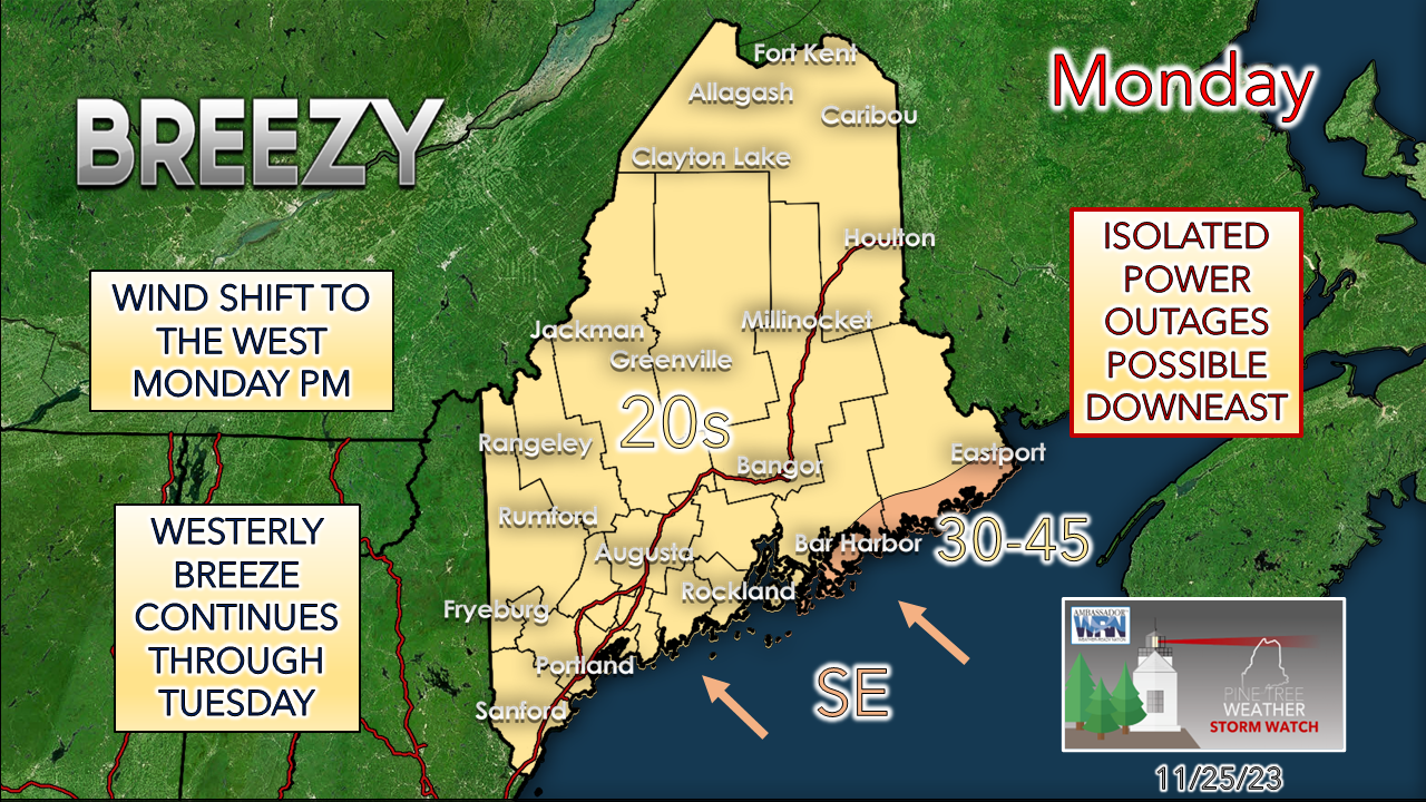 The low-level jet appears to hang far enough offshore to spare the southwest coast of stronger gusts, although the islands may see 30-35 mph. DownEast areas may get a wind advisory out of this, with a better chance for Washington County. In the spirit of Small Business Saturday... Thank you for your years of following and for your financial support. It is because of your funding that this operation continues. God bless and stay strong. Be good to yourself. Stay updated, stay on alert, and stay safe! - Mike NOTE: The forecast information depicted on this platform is for general information purposes only for the public and is not designed or intended for commercial use. For those seeking pinpoint weather information for business operations, you should use a private sector source. For information about where to find commercial forecasters to assist your business, please message me and I will be happy to help you. |

Mike Haggett
|


