Pine Tree Weather
  • DISCUSSIONS
  • DONATE
  • WEATHER WALL
  • MAPS
  • RAIN OUTLOOK
  • SEVERE
  • MARINE
  • CPC OUTLOOK
  • Kennebunk
  • MY BIO
  • PTW IN MEDIA
  • OBSERVING WEATHER
  • INTERNSHIPS
  • INTERN ALUMNI
  • DISCUSSIONS
  • DONATE
  • WEATHER WALL
  • MAPS
  • RAIN OUTLOOK
  • SEVERE
  • MARINE
  • CPC OUTLOOK
  • Kennebunk
  • MY BIO
  • PTW IN MEDIA
  • OBSERVING WEATHER
  • INTERNSHIPS
  • INTERN ALUMNI

Scattered storms on Sunday, then hot temperatures and humidity return for the week ahead

7/4/2020

Comments


Scattered showers and storms for Sunday

Picture
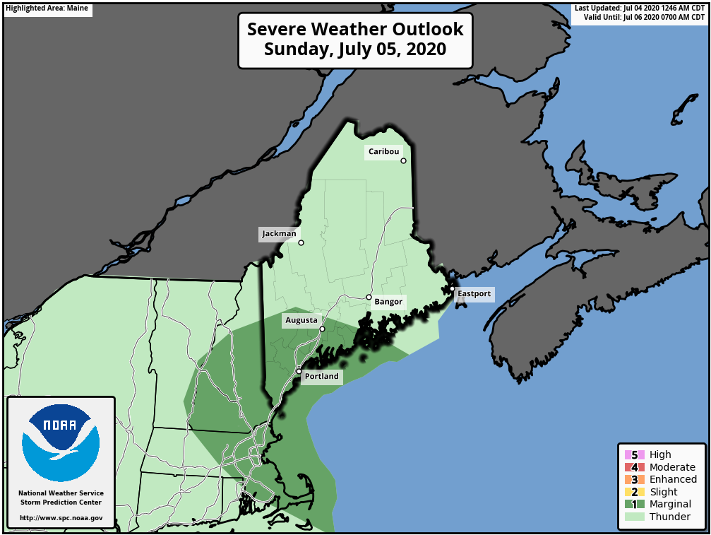
A front will cross the region during the afternoon on Sunday, bringing showers and some isolated thunderstorms with it. Most of the state is in a general thunderstorm risk, with southwestern regions in the marginal risk (level 1 out of 5). Cloud cover during the daytime may limit the thunderstorm threat throughout the state, however, temperatures and dewpoints in the southwest regions may be sufficient to feed a few stronger thunderstorms. The largest threat with the storms, especially the ones that pop up in the southwest, will be hail and gusty winds. 
Picture
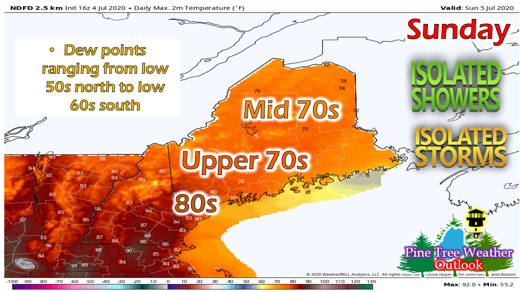
​Temperatures on Sunday will range from mid 70s up north to 80s down south. It will remain fairly dry throughout the state with the exception of southwestern regions that could see a few isolated mid 60s for dew points. Winds will be a little all over the place as the front moves through. Northern regions of the state will generally see a NW/N wind at around 4-7 mph. Southern/central regions will generally see a southerly wind at around 5-9 mph but increasing as you head towards the coast. 

Overnight, temperatures will range from the low 50s north to upper 50s south. Northwestern regions could even drop down into the upper 40s. Showers will linger into the overnight hours and an isolated thunderstorm cannot be ruled out. Fog is likely overnight, especially along the coast and in areas that it rained. 

Temperatures increasing throughout the week

Picture
Temperatures will gradually increase throughout the week, reaching the upper 80s by Friday. Humidity will also return midweek and persist through the end of the week. Expect dew points in the upper 60s and low 70s throughout the south and decreasing into the low 60s as you move north. 

Next chance for rain on Wednesday

Picture
A low pressure system will approach the region on Wednesday. This low pressure system will feature a warm front that will swing through the state on Wednesday, then a cold front on Thursday. Showers and thunderstorms will be likely on Wednesday, transitioning to mostly showers on Thursday. 

Help forecast verification, and stay informed!

Picture
​mPINGers Wanted! Report your weather anywhere anytime anonymously and help improve forecast verification. No special training required. Download the mPING app and start reporting what you see from any location.  For more information, check out the mPing site. ​

Picture
Hiking, camping or boating this summer?
BE PREPARED WITH A
 NOAA Weather Radio.

​For $20-$40, it could provide important information to you when you need it. The weather bands are standard on most public safety scanners, and newer scanner models and weather radios can be programmed for auto alert.  Click here for more information.

Picture
► ► For the latest official forecasts, bulletins and advisories, please check in with the National Weather Service in Gray for western and southern areas, or Caribou for northern and eastern parts of Maine.
For more information, please follow Pine Tree Weather on Facebook and Twitter. 

Thank you for supporting this community based weather information source that is funded by your financial contributions. 

Stay updated, stay on alert, and stay safe!

Make it a great day!
​- Alex :)
Comments
    Picture

    Mike Haggett
    Kennebunk, ME

    Weather-Ready Nation
    Ambassador

    Certified Weather
    Forecaster
    Penn State '21

    American Meteorological Society

    National Weather Association
    ​
    ​SKYWARN-CWOP

    Matthew 19:26


    DONATE

    Picture
    Picture
    Picture
    Picture
    Picture

    Picture

    Picture

    Picture

    Picture

    Picture

    Picture

    Picture

    Picture

    Picture

    Picture

    Picture

    Picture


    Archives

    April 2025
    March 2025
    February 2025
    January 2025
    December 2024
    November 2024
    October 2024
    September 2024
    August 2024
    July 2024
    June 2024
    May 2024
    April 2024
    March 2024
    February 2024
    January 2024
    December 2023
    November 2023
    October 2023
    September 2023
    August 2023
    July 2023
    June 2023
    May 2023
    April 2023
    March 2023
    February 2023
    January 2023
    December 2022
    November 2022
    October 2022
    September 2022
    August 2022
    July 2022
    June 2022
    May 2022
    April 2022
    March 2022
    February 2022
    January 2022
    December 2021
    November 2021
    October 2021
    September 2021
    August 2021
    July 2021
    June 2021
    May 2021
    April 2021
    March 2021
    February 2021
    January 2021
    December 2020
    November 2020
    October 2020
    September 2020
    August 2020
    July 2020
    June 2020
    May 2020
    April 2020
    March 2020
    February 2020
    January 2020
    December 2019
    November 2019
    October 2019
    September 2019
    August 2019
    July 2019
    June 2019
    May 2019
    April 2019
    March 2019
    February 2019
    January 2019
    December 2018
    November 2018
    October 2018
    September 2018
    August 2018
    July 2018
    June 2018
    May 2018
    April 2018
    March 2018
    February 2018
    January 2018
    December 2017
    November 2017
    October 2017

Proudly powered by Weebly