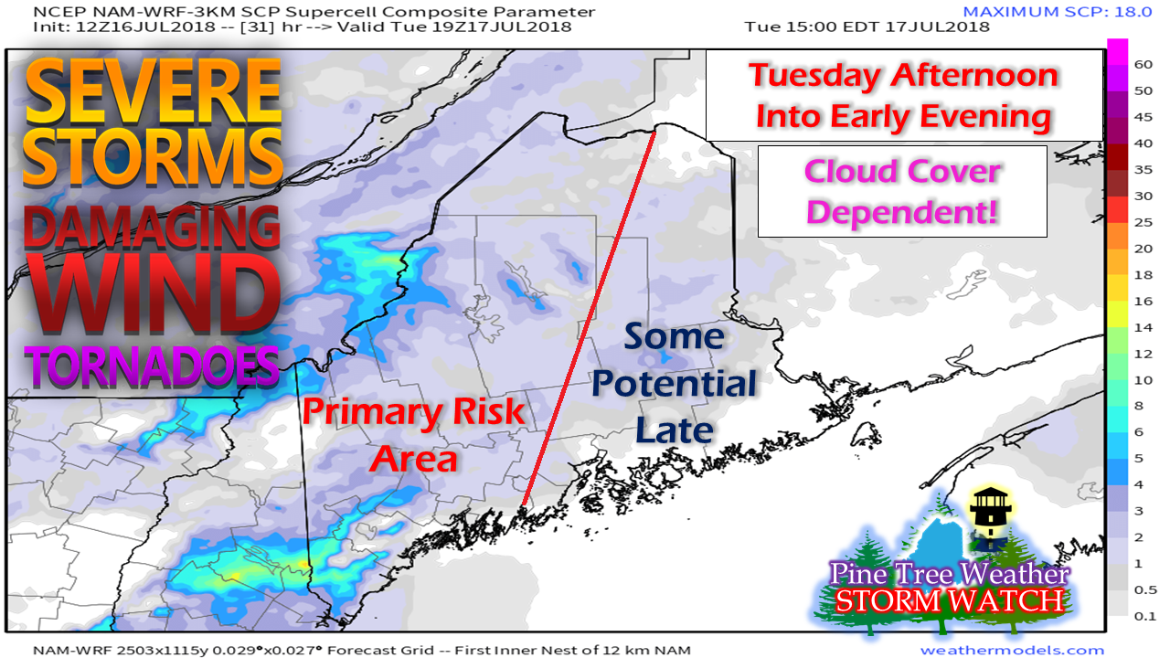
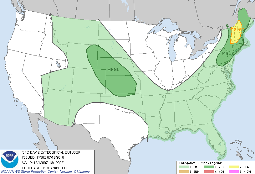
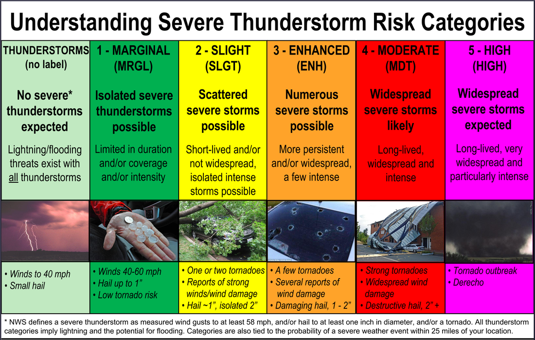
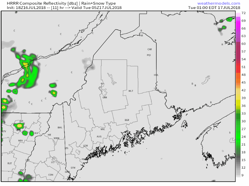
Pine Tree Weather
  • DISCUSSIONS
  • DONATE
  • MAPS
  • NWS BRIEFINGS
  • SATRAD
  • MARINE
  • SNOW / ICE OUTLOOK
  • RAIN OUTLOOK
  • CPC OUTLOOK
  • Kennebunk
  • OBSERVING WEATHER
  • Who We Are
  • My Photography
  • DISCUSSIONS
  • DONATE
  • MAPS
  • NWS BRIEFINGS
  • SATRAD
  • MARINE
  • SNOW / ICE OUTLOOK
  • RAIN OUTLOOK
  • CPC OUTLOOK
  • Kennebunk
  • OBSERVING WEATHER
  • Who We Are
  • My Photography

Severe storms likely for much of the region Tuesday

7/16/2018

Comments


Potential for a rough afternoon Tuesday
​in western and southern areas

Picture
The one thing many folks are looking for is rain. The good news is a soaker appears on the way. The side effect of this heavy watering event will be in the form of severe storms. The important piece in this on the graphic above is "Cloud Cover Dependent!" which means, if you are in an area that is buried in cloudiness, your chances for severe weather could be lower. If you see sun for any period of time (southern and western areas, this means YOU!) it could get rather hairy in places in the afternoon as we head into the evening. 

The region is already on SPC's radar

Picture
.It's not very common that Storm Prediction Center posts a slight risk for severe storms in our region a day ahead of the event. This is from their Day 2 Outlook (time sensitive). It's usually the day of the event where risks get elevated. What makes this threat elevated is the steep nature of the approaching cold front in combination with a tropical moisture hose that stems all the way to the Gulf of Mexico.

Important wording here from SPC:

...Northeast... The severe thunderstorm threat will increase late Tuesday morning into the afternoon along and ahead of the approaching cold front, though the magnitude of the threat remains somewhat uncertain due to the potential for widespread cloudiness and early day convection. With weak midlevel lapse rates expected, the magnitude of the buoyancy will be largely determined by diabatic heating (or lack thereof). However, with rich low-level moisture in place and the potential for broken clouds/insolation, along with an increase in low-midlevel flow/shear ahead of the cold front, a Slight Risk appears warranted from western MA/far eastern NY northward into portions of VT/NH/western ME. Damaging wind gusts are expected to be the primary hazard, though a brief tornado will also be possible, especially across the northern portion of the risk area where a relative backing of low-level flow is expected.

Editor's Note: Let's define "northern areas"... roughly the area around Route 2 west and north over to Skowhegan and up Route 201 around Jackman and all areas in between. Sugarloaf, Rangeley, Mount Blue, The Bigelows, The Forks... this means you. That isn't to say the area doesn't spread more east and/or south.  Again, this is cloud cover dependent! 

From National Weather Service Gray Area Forecast Discussion:

.SHORT TERM /6 AM TUESDAY MORNING THROUGH TUESDAY NIGHT/... Tuesday will be a classic severe weather set up. The morning starts off with fog and low stratus along the coast. This fog will dissipate by mid morning leaving a humid airmass primed for convection. A cold front approaching from the west will be the trigger needed to get storms going. The front will arrive into our far northwestern zones in the early morning crossing the entire area from west to east reaching the coastline around 22Z (6 PM). With CAPE values of 1500 J/kg along with shear of 30+ kts expect an organized convective line with severe wind gusts as the main threat. Ahead of the line the humid airmass and low level southerly and onshore flow will provide some low level turning of the winds. If any storms are able to initiate ahead of the main line there will be a threat for tornadoes within these cells.

In addition to the severe threat, flash flooding will be a concern. Dewpoints in the upper 60s to near 70s with PWAT values approaching 2" will provide plenty of moisture for storms. Coupled with a deep warm rain layer and you get very heavy rain rates. The big issue here will be whether the storms are training in one location. If the line is able to remain progressive through the entire region significant flooding would likely be avoided however even minor changes in direction of the line will serve to focus the precipitation in one area. Despite the potential for flooding have opted not to issue a Flash Flood watch at this point as the total area likely to experience flooding will likely be relatively small and with the line passing through the entire region its hard to favor one portion of the CWA over another for flood risk.

Editor's Note: Plenty of potential threats to watch out for. "Training" is a line of storms one after another over a certain area. This won't be determined until the event unfolds. I suspect there will be flash flooding in areas... the jury is out whether a widespread area will see that sort of impact.

As dry as it has been, damage from gusty winds on trees is going to be a concern for power outages. The Portland and Old Town areas got hammered last week. There is potential for more areas of wind damage with this event. 
Picture
As of Monday afternoon, the area is in the marginal or slight risk for severe potential. The possibility exists where that risk could become enhanced.  If you are reading this on Tuesday, it would be wise to check the Day 1 Outlook (time sensitive) for the latest information. 

POTENTIAL IMPACTS: Frequent lightning, heavy to torrential rainfall, flash flooding, damaging wind, hail and tornadoes. 

Timing...

Picture
There could be some early morning thunderstorm activity in western areas which may cause the cloudiness to hold on, deterring the severe threat. That will be a wait-and-see scenario. Southern areas may see an isolated shower or storm in the morning, but the main event will come in the afternoon.

Any of these severe warned storms should be taken very seriously. When thunder roars, get indoors IMMEDIATELY. Make sure you are tuned into the National Weather Service of have a decent weather alert app on your smartphone to alert you of impending severe weather. 

After the front passes through, showers end overnight into early Wednesday morning.

Rain glorious rain!

Picture
Keep in mind that some areas will get more from strong to severe storms, and potentially less for areas that don't get in on the fireworks. Flash flooding is a real likelihood given the amount of moisture around. That will occur in the areas of torrential downpours. REMEMBER - TURN AROUND DON'T DROWN when you come across a flooded roadway! 

Drier air returns on Wednesday

Picture
The humidity continues to build into Tuesday as the frontal boundary pumps tropical air into the state. It will be "weather-you-can-wear" until late Tuesday evening for the higher elevations of western areas, and then gradually fall in southern and eastern areas through the day on Wednesday. 

Regional Outlook Through Saturday

Picture
Outside of Tuesday's severe weather event, the region returns to dry times for the remainder of the week and into the weekend. The next rain event is possible early next week.

For official bulletins, advisories and forecast information, please check in with the National Weather Service in Gray for western and southern Maine, or Caribou for eastern and northern areas.

For more information from me, including an updates on Tuesday, please follow Pine Tree Weather on Facebook and on Twitter for real time updates.

Stay on alert,  and stay safe!
Comments
    Picture

    Mike Haggett
    Kennebunk, ME

    Certified Weather
    Forecaster
    Penn State '21

    American Meteorological Society

    National Weather Association

    Weather-Ready Nation 
    Ambassador
    ​
    ​SKYWARN-CWOP

    Matthew 19:26


    Support
    Pine Tree Weather

    DONATE

    Picture

    Picture

    Picture

    Picture

    Picture

    Picture

    Picture

    Picture

    Picture

    Picture

    Archives

    January 2023
    December 2022
    November 2022
    October 2022
    September 2022
    August 2022
    July 2022
    June 2022
    May 2022
    April 2022
    March 2022
    February 2022
    January 2022
    December 2021
    November 2021
    October 2021
    September 2021
    August 2021
    July 2021
    June 2021
    May 2021
    April 2021
    March 2021
    February 2021
    January 2021
    December 2020
    November 2020
    October 2020
    September 2020
    August 2020
    July 2020
    June 2020
    May 2020
    April 2020
    March 2020
    February 2020
    January 2020
    December 2019
    November 2019
    October 2019
    September 2019
    August 2019
    July 2019
    June 2019
    May 2019
    April 2019
    March 2019
    February 2019
    January 2019
    December 2018
    November 2018
    October 2018
    September 2018
    August 2018
    July 2018
    June 2018
    May 2018
    April 2018
    March 2018
    February 2018
    January 2018
    December 2017
    November 2017
    October 2017

    RSS Feed

Proudly powered by Weebly