Scattered storms continue into the evening, severe threat decreases as the sun sets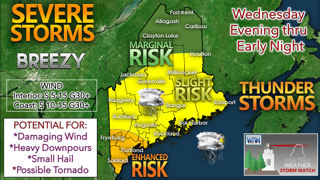 There is plenty of instability in the atmosphere with the hot and humid airmass still in place. Severe thunderstorm watches are in effect until 7 pm tonight for everyone except Aroostook County. The cold front will continue its slow drop from Canada through the area tonight before stalling over southern New England Thursday morning. Thunderstorm activity will begin to transition to scattered showers as the instability decreases with another warm and muggy night, especially across southern portions of the state. Wednesday night expect some leftover showers with patchy fog possible and partial clearing. Cooler and drier air begins to enter the north allowing for lows to drop in the 60s while southern areas will only drop into the low 70s. Seasonable conditions with rain showers on Thursday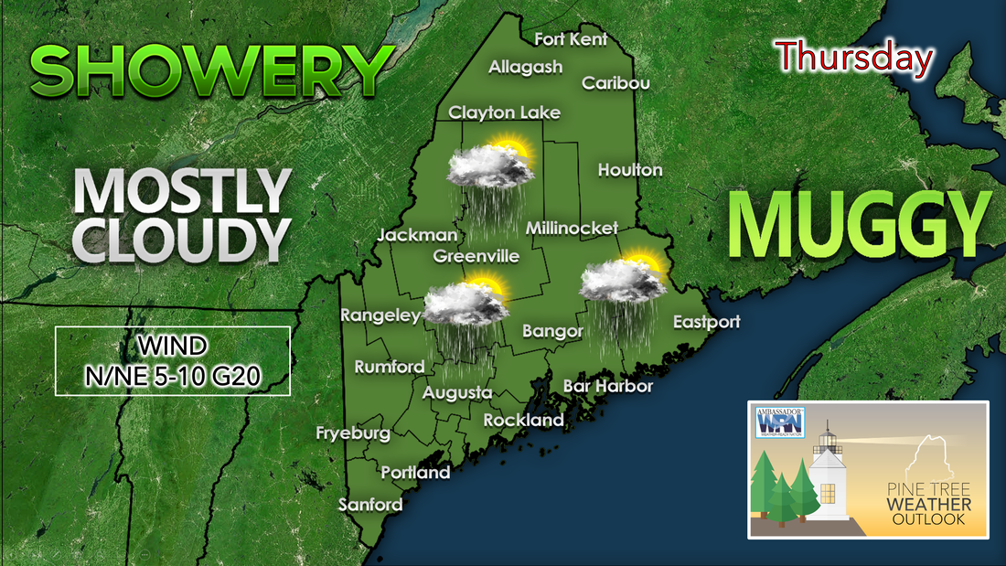 The cold front on Thursday remains stalled near southern New Hampshire with waves of low pressure forming along the boundary. This will bring mostly cloudy skies with chances of showers increasing through the afternoon across much of the state. Cloud cover will keep high temperatures primarily in the low 80s to the south and low 70s to the north. An offshore flow should make for a weaker sea breeze keeping places along the coast into the 70s. Drier air will enter northern areas allowing dewpoints to drop into the 50s while south of the mountains, closer to the boundary, dew points will still be in the upper 60s making it feel muggy once again. Thursday night into Friday we could see another round of showers and steadier rain possible mainly across southern Maine. Lesser shower chances northward as a more rapid southward movement could focus the most extensive showers across the Gulf of Maine. A cool-down for Friday with chances of unsettled weather continuing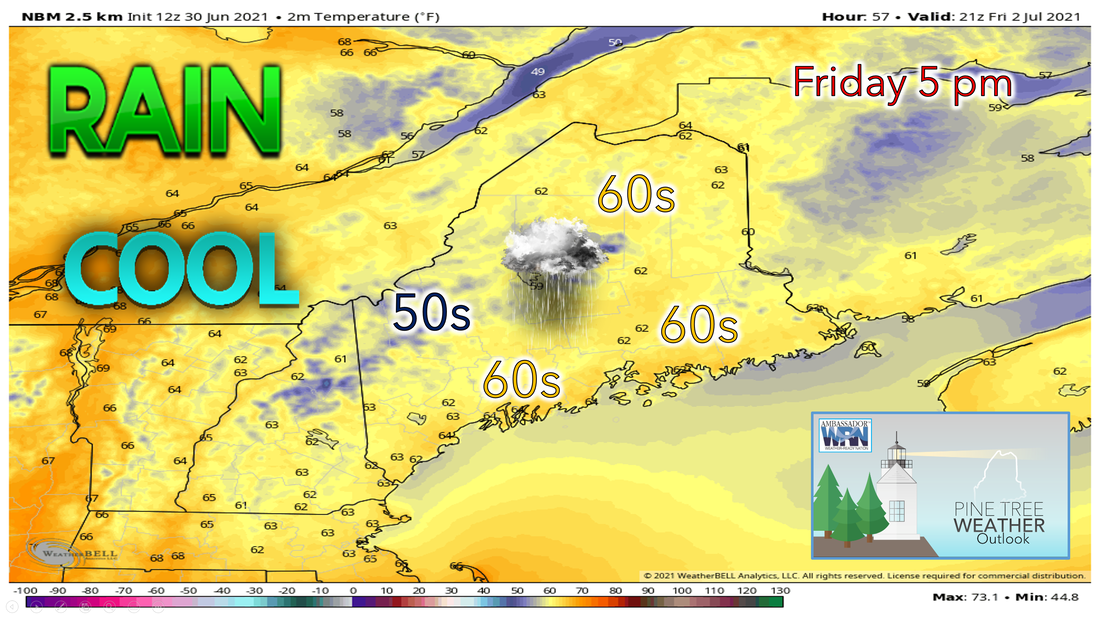 Another low-pressure system will work its way along the northeast coast on Friday. This will bring another chance for some light to moderate rain showers in the central, south, and coastal parts of the state. An upper-level trough will be deepening over the Great Lakes and will interact with this feature. It looks increasingly likely that showers and thunderstorms will develop towards the northwest from the Main coast and into western Maine. Rain will spread across the state from south to north starting early in the morning and reaching central Maine by mid-afternoon. Rain will eventually clear out, with just a few scattered showers remaining in the south after nightfall. Temperatures will reach the lower 60s just inland of the coast while to the north, temperatures will stay in the upper 50s. A sea breeze will develop and should keep the coast from reaching 60°F. Holiday weekend outlook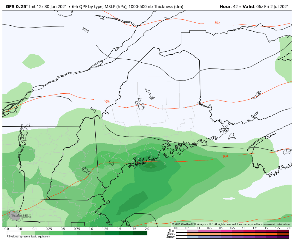 An unsettled weather pattern will remain as we head into the weekend. A series of disturbances will track just offshore and move off to the northeast. There will be a chance for showers each day over the weekend, especially for southern Maine and all along the coastal regions. Most models are in fairly good agreement on precipitation but exactly how much rainfall would result in less certainty. Showers and storms that do develop in these areas would likely be slow-moving, so the possibility of some heavy rainfall will need to be monitored. However, the holiday weekend does not look be a complete washout. Temperatures will be seasonably cool throughout the weekend statewide. Conditions will also feel much more comfortable as dewpoints will be low. You can expect high temperatures to primarily be in the 60s and 70s. High pressure will begin to move in for Monday as skies will be partly cloudy, and temperatures will be in the high 70s. Overall outlook through the weekend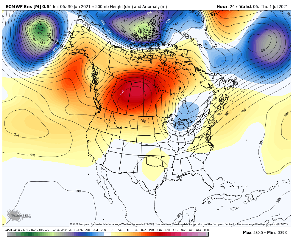 The dangerous heat out west across interior sections of the Northwest and Northern Rockies has peaked and will begin to diminish over the next few days. Oppressive heat throughout the Mid-Atlantic and Northeast will diminish as well as a cold front produces rain and severe weather chances by this evening. Cooler and drier air will move into the northeast over the weekend as a trough begins to develop. This will decrease temperatures, decrease humidity, and increase rain chances for Maine into early next week. Temperature outlook through late JuneThe plots below show the trend of the high and low temperatures for Carrabassett, Bangor, Caribou, and Portland over the next week and a half. Temperatures and humidity begin to drop as we close out the workweek. Temperatures will drop down to more seasonable heading into the fourth of July weekend. Showers and unsettled weather will continue into early next week. Temperatures look to be seasonable to slightly above average to start the new week. 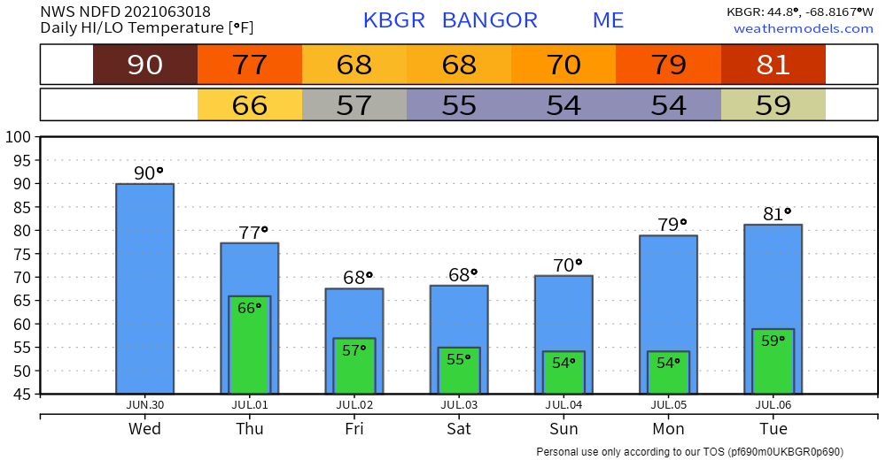 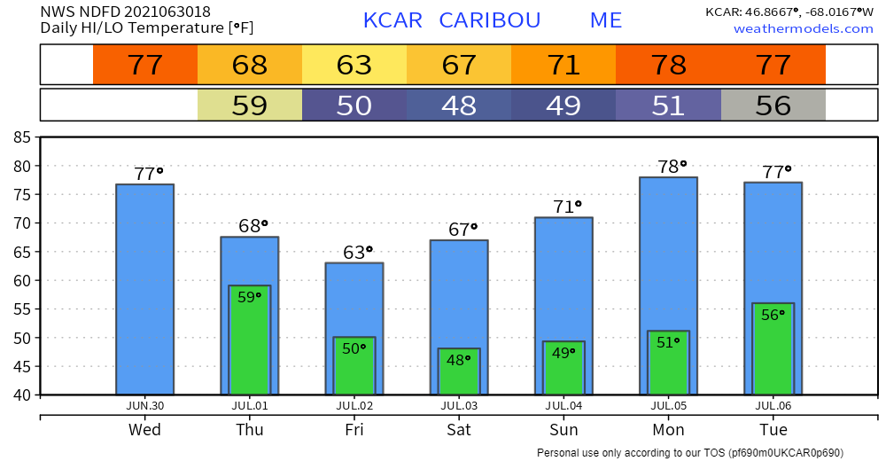 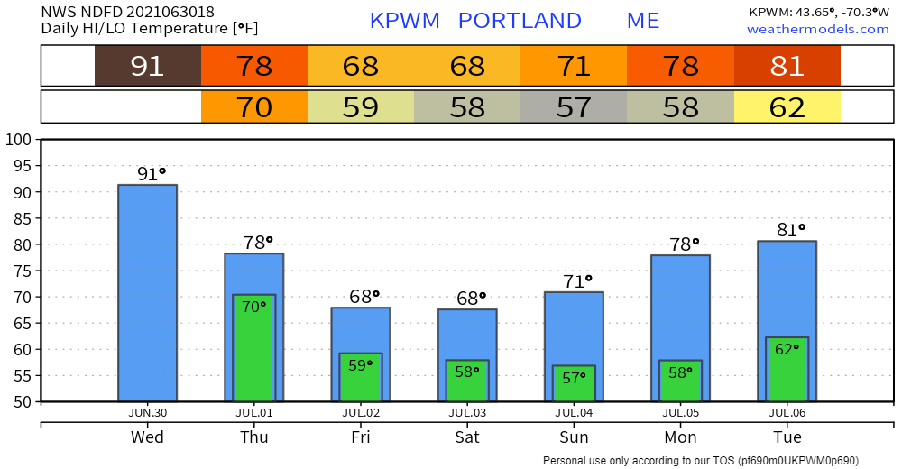 Practicing heat safety Heat is one of the leading weather-related killers in the United States, resulting in hundreds of fatalities each year. Heat can be very taxing on the body; check out the heat related illnesses that can occur with even a short period of exposure. Everyone can be vulnerable to heat, but some more so than others. www.weather.gov/safety/heat Be prepared to receive alerts and stay updated!
For more information in between posts, please follow Pine Tree Weather on Facebook and Twitter.
Thank you for supporting this community-based weather information source which operates by reader supported financial contributions. Stay updated, stay on alert, and stay safe! |

Mike Haggett
|