Pine Tree Weather
  • DISCUSSIONS
  • DONATE
  • WEATHER WALL
  • MAPS
  • RAIN OUTLOOK
  • SEVERE
  • MARINE
  • CPC OUTLOOK
  • Kennebunk
  • MY BIO
  • PTW IN MEDIA
  • OBSERVING WEATHER
  • INTERNSHIPS
  • INTERN ALUMNI
  • DISCUSSIONS
  • DONATE
  • WEATHER WALL
  • MAPS
  • RAIN OUTLOOK
  • SEVERE
  • MARINE
  • CPC OUTLOOK
  • Kennebunk
  • MY BIO
  • PTW IN MEDIA
  • OBSERVING WEATHER
  • INTERNSHIPS
  • INTERN ALUMNI

Showers to start to the weekend; unsettled week ahead

5/14/2020

Comments


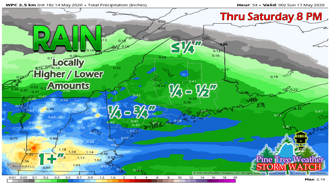
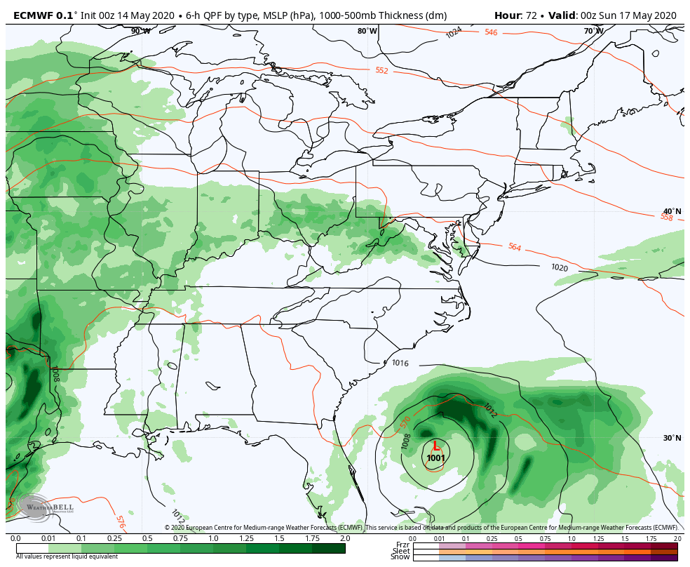
It's been a rough start to May

Picture
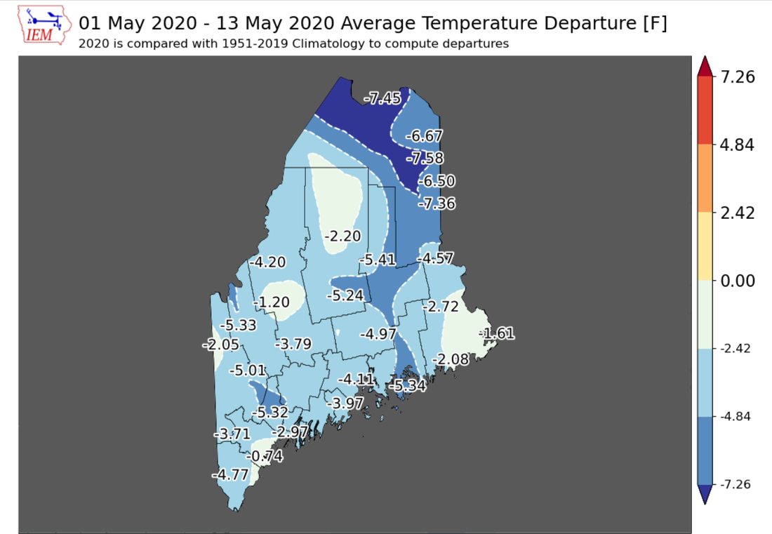
It's rather eye opening to see the hard data on how chilly it has been. The seasonal average is above normal for the spring as a whole, thanks to a abnormally warm March, but that can be considered false spring the way April and the first half of May have gone.
Picture
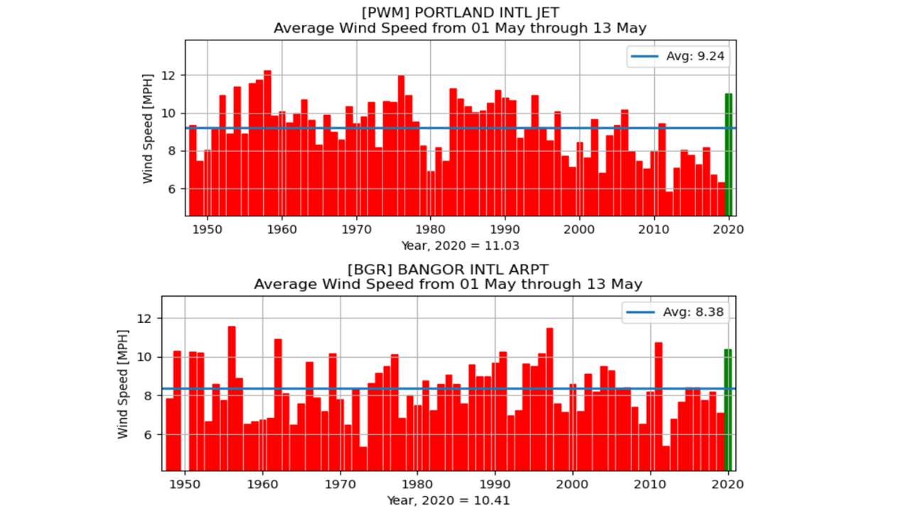
Wind has been above average so far for all areas south and west of Houlton. Portland's average speed is near a 30 year high. Bangor's is a solid 2 mph over average. Sampling other site data, Greenville is 3 mph over average through the first 13 days of May (10.98 mph vs 7.11 mph). With the cold draining from the north, this has kept the anemometers busy. 
Picture
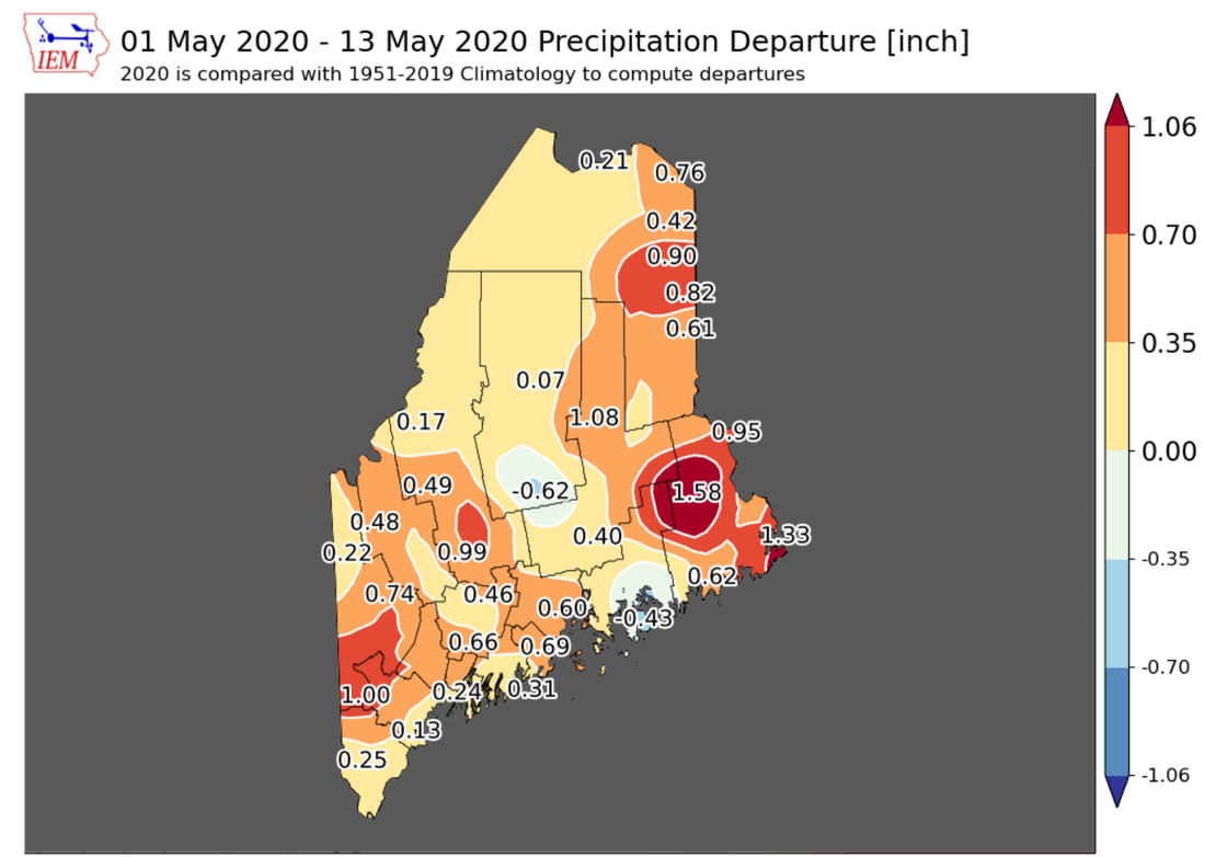
No drought concerns here to start spring, for a change. Most areas reporting above normal rainfall so far through the month. 
Picture
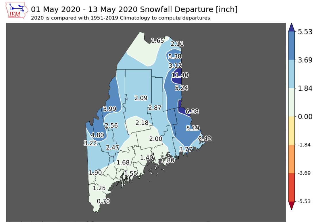
This month will likely be remembered for a long time for the late season snowfall, if anything else. It was 188 days since Caribou received it's first trace amount of snow until it's last. Mount Katahdin may not be done with snow yet, but the rest of the region is finished. Six months is long enough. 

Friday brings rain to Maine 
with nasty storms to south and west

Picture
It didn't take long to go from snow weather to severe weather. It is shaping up to be a rough afternoon for our neighbors with tornadoes, damaging wind, large hail, flash flood potential downpours and frequent lightning. With a ridge trying to work its way north meeting the abnormal cold that has been around all week, its not a good combination.  
Picture
NAM model radar idea from 8 PM Thursday to 8 PM Friday
The ridge pushes a warm front northward Thursday night into Friday. The boundary will set off shower activity across it Friday morning for all but southern areas. That will change by afternoon as the stronger storms develop from the heating of the day and show up to southern and western areas Friday evening. 

I can't rule out a strong or severe storm Oxford, Cumberland and York Counties, but timing will be the key. If storms fire up ahead of schedule Friday afternoon, the heating may assist development. The projected timing here of 6-8 PM is up against sunset, and that may fizzle them out with little fanfare, other than heavy rain as the atmosphere cools. 
Picture
NAM model radar idea from 8 PM Friday to 8 PM Saturday
Storms will pass through the region Friday night and end over southern areas in the wee hours of Saturday. Showers continue over northern and eastern areas Saturday morning, ending by around mid-afternoon. 
Picture
A solid rain amount for most out of this. Southern and western areas could see higher amounts from stronger storms with associated downpours. 

Outlook into next week: unsettled

Picture
European model 500mb cyclonic vorticity forecast from 8 PM Saturday 5/16 to 8 PM Saturday 5/23
This is an upper level vorticity (energy) loop shows three key features. First, the subtropical system in the southeast. Second, a cold front passing through the Gulf coast and Florida. Third, and most important for our region, a shortwave trough that turns into a cut-off upper level low. The subtropical system gets booted out to sea as the cold front and shortwave trough move east. Unfortunately for the much of the eastern half of the country, this cut-off upper low has nothing to steer it away until late week before it can be moved along. 
Picture
Looking at it from the surface, the cut-off upper low appears to bring a varying amount of clouds and rain as it meanders around waiting for the boot to arrive around Friday. Time will ultimately tell how this will impact our region. Southern areas have the best chance for clouds and precipitation next week. How much further north is yet to be seen. 
Picture
While the cut-off upper low and associated trough will keep the region on the cool side, temperatures generally range close to seasonal average with 50s/60s with Monday likely the coolest day for southern areas in the 50s. 

For you gardeners, no concerns for frost at this point. The rooftop of The County may not be out of the woods just yet, but the rest of the region sees mainly 40s for overnight lows through the week ahead. 

Keep your fingers crossed this European model idea is right with 70s to around 80° on tap to kick off Memorial Day weekend. 

Stay informed!

Picture
Hiking, camping or boating this summer?
BE PREPARED WITH A
 
NOAA Weather Radio.

​For $20-$40, it could provide important information to you when you need it. The weather bands are standard on most public safety scanners, and newer scanner models and weather radios can be programmed for auto alert.  
Click here for more information. ​

Picture
​► ► For the latest official forecasts, bulletins and advisories, please check in with the National Weather Service in Gray for western and southern areas, or Caribou for northern and eastern parts of Maine.

​For more information, please follow Pine Tree Weather on Facebook and Twitter. 

Thank you for supporting this community based weather information source that is funded by your financial contributions. 

Stay on alert, stay updated, and stay safe!

​- Mike
Comments
    Picture

    Mike Haggett
    Kennebunk, ME

    Weather-Ready Nation
    Ambassador

    Certified Weather
    Forecaster
    Penn State '21

    American Meteorological Society

    National Weather Association
    ​
    ​SKYWARN-CWOP

    Matthew 19:26


    DONATE

    Picture
    Picture
    Picture
    Picture
    Picture

    Picture

    Picture

    Picture

    Picture

    Picture

    Picture

    Picture

    Picture

    Picture

    Picture

    Picture

    Picture


    Archives

    April 2025
    March 2025
    February 2025
    January 2025
    December 2024
    November 2024
    October 2024
    September 2024
    August 2024
    July 2024
    June 2024
    May 2024
    April 2024
    March 2024
    February 2024
    January 2024
    December 2023
    November 2023
    October 2023
    September 2023
    August 2023
    July 2023
    June 2023
    May 2023
    April 2023
    March 2023
    February 2023
    January 2023
    December 2022
    November 2022
    October 2022
    September 2022
    August 2022
    July 2022
    June 2022
    May 2022
    April 2022
    March 2022
    February 2022
    January 2022
    December 2021
    November 2021
    October 2021
    September 2021
    August 2021
    July 2021
    June 2021
    May 2021
    April 2021
    March 2021
    February 2021
    January 2021
    December 2020
    November 2020
    October 2020
    September 2020
    August 2020
    July 2020
    June 2020
    May 2020
    April 2020
    March 2020
    February 2020
    January 2020
    December 2019
    November 2019
    October 2019
    September 2019
    August 2019
    July 2019
    June 2019
    May 2019
    April 2019
    March 2019
    February 2019
    January 2019
    December 2018
    November 2018
    October 2018
    September 2018
    August 2018
    July 2018
    June 2018
    May 2018
    April 2018
    March 2018
    February 2018
    January 2018
    December 2017
    November 2017
    October 2017

Proudly powered by Weebly