Pine Tree Weather
  • DISCUSSIONS
  • DONATE
  • MAPS
  • NWS BRIEFINGS
  • SATRAD
  • MARINE
  • SNOW / ICE OUTLOOK
  • RAIN OUTLOOK
  • CPC OUTLOOK
  • Kennebunk
  • OBSERVING WEATHER
  • Who We Are
  • My Photography
  • DISCUSSIONS
  • DONATE
  • MAPS
  • NWS BRIEFINGS
  • SATRAD
  • MARINE
  • SNOW / ICE OUTLOOK
  • RAIN OUTLOOK
  • CPC OUTLOOK
  • Kennebunk
  • OBSERVING WEATHER
  • Who We Are
  • My Photography

Showers with a risk for thunderstorms through Tuesday

5/15/2022

Comments

 
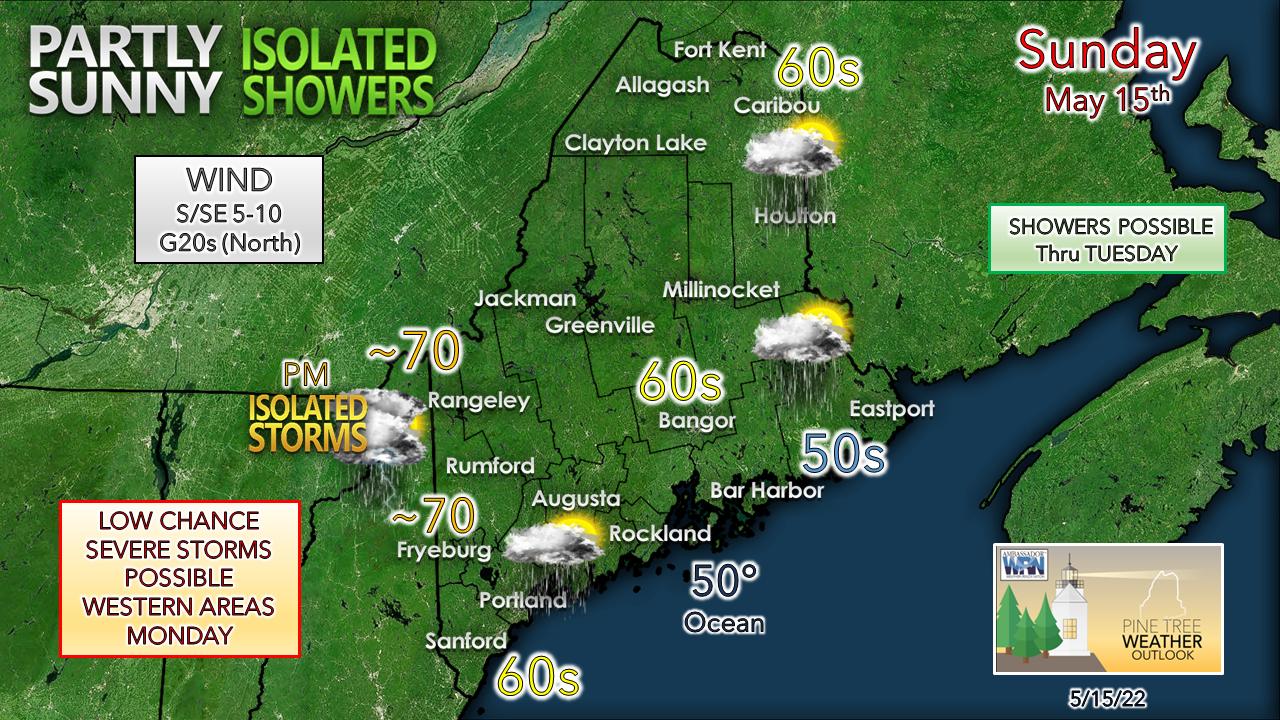
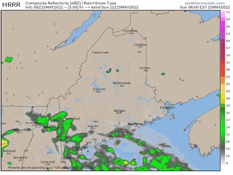
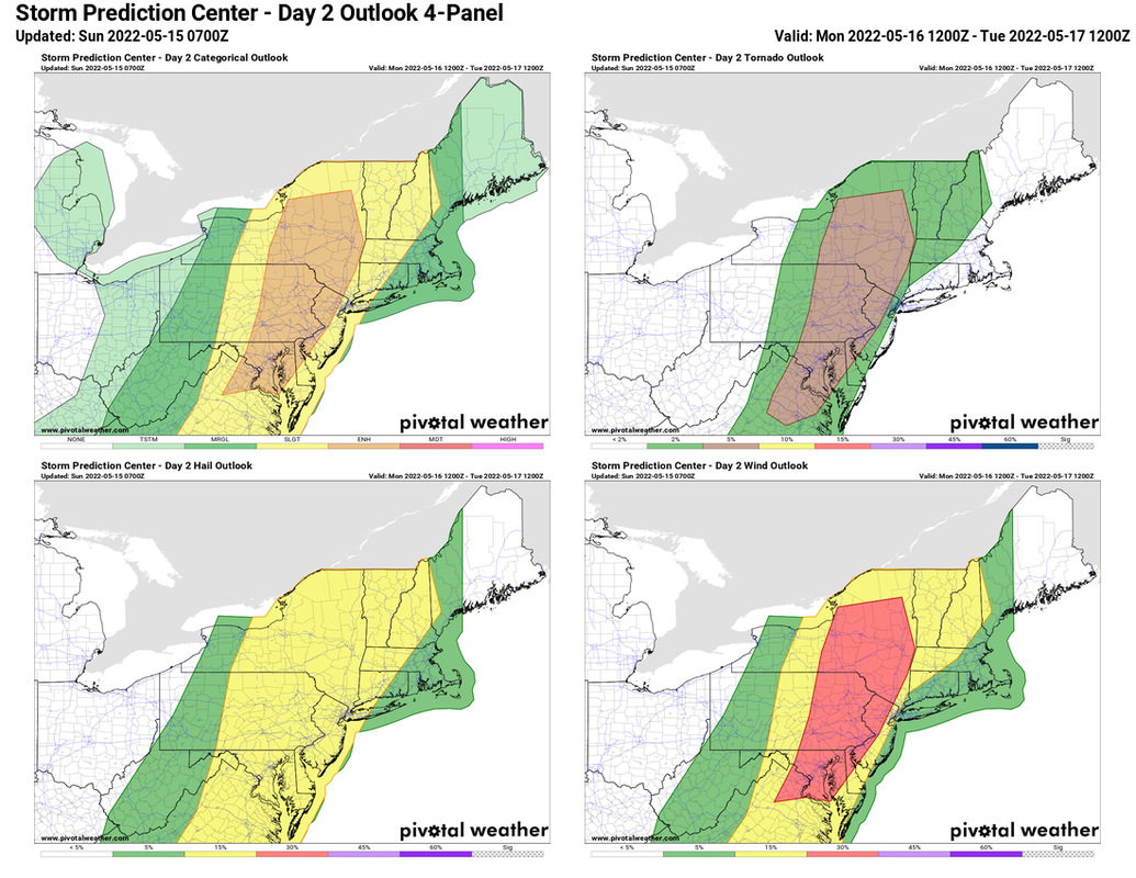
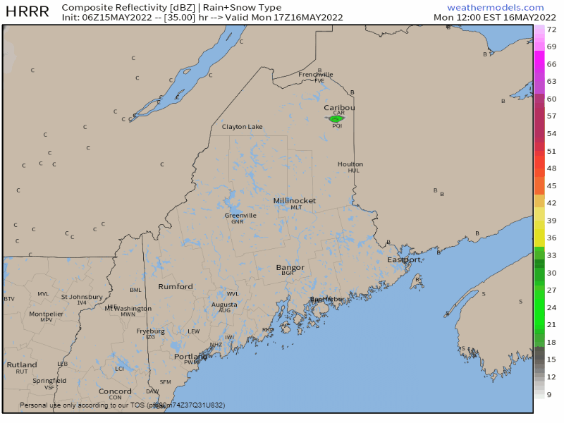
It's nice to post a discussion on the website once again. While I have been fairly frequent in posting a daily synopsis on Facebook during the work week, this space has been neglected for a while. I hope to come up with a format that better utilizes the website here that works in my daily life soon.

Since my mother-in-law passed back in early March, I missed the key college recruiting period for interns. With COVID restrictions lifted and in-person internships once again widely available, interest in what I do here was limited. Therefore, I will be operating this entity by myself going forward. I will do what I can, when I can, as best as I can. I will do my best to update as often as possible. 

A cooler day with showers and a risk of a rumble
for western areas Sunday

Picture
The ridge responsible for the recent taste of summer heat and humidity is beginning to break down. A cold front has stalled out across western Maine. Disturbances riding along it are expected to touch off shower activity at times through the day and into Sunday night.  
Picture
Sunday 6 AM to Midnight: While the day won't be a washout, all areas have the chance of receiving a few raindrops at some point in the day. Folks in western and southern areas should be mindful of any sun that happens to poke through in the afternoon. With dew point temperatures in the 60s, there is fuel around to generate a pop-up thunderstorm through early evening. While not expected to be severe, any storms that form could be similar to Saturday which brought downpours and lightning.  As the sun sets, the threat of storms diminishes, but a rain shower is possible into the wee hours of Monday.

Strong to severe storms possible
​for western and southern areas Monday

Picture
The cold front over Maine Sunday turns into a slow-moving warm front for Monday. A surge of moisture from the south keeps conditions muggy. While the best chance for severe weather is west of the state, it's a timing game as for whether the western half of the region has a chance to get in on the action.
Picture
Since I use the SPC charts frequently as other NOAA and media outlets, I offer this as a refresher. In regard to Monday, most of the western half of the state is in the marginal risk category, with slight risk potential for extreme western areas as of the Day 2 Outlook (time sensitive technical discussion link).

Please note that on this website the 3-day severe weather outlook page has re-emerged from winter hibernation for your access via desktop or mobile anytime and is automatically updated as SPC releases their latest outlook. You may find this handy to plan your work or vacation days. Please check out the other tabs with information that you may find useful as well. 
Picture
Monday Noon to Tuesday 1 AM: The morning hours appear dry, but that changes heading into the afternoon. Frequency of showers with the threat of storms increases heading into the afternoon as the cold front approaches from the west.

Whether or not severe storms occur is dependent upon the timing of the progression of the front. While the HRRR model idea suggests outflow storms may pop out ahead of the squall line from the west, it will be cloud cover dependent. As the sun sets in the evening, the risk for strong storms diminishes with reduced daylight. I can't rule out the risk of an overnight rumble heading into early Tuesday morning. 

Folks camping out need to be advised of the threat of heavy downpours which may cause localized flash-flooding. Gusty wind, hail, and a low chance of a tornado are all possible IF severe weather conditions materialize. 

Showers remain in the forecast through Tuesday

Picture
Tuesday 2 AM to Wednesday 8 PM: While the cold front is expected to clear the region by early Tuesday morning, the parent low to the northwest associated with an upper-level trough is expected to keep showers possible for interior areas through Tuesday.

​The peaks of the western mountains may see a snow shower heading into Wednesday morning as cold air moves in as the low heading into eastern Canada. High pressure moves into the region for Wednesday. Far northern areas run a risk for frost Thursday morning. 

Temperature outlook through Friday

The normal high and low temperature for Caribou for May 15th is 63° and 41°. For Portland, 64° and 45°. Temperatures are expected to be generally above normal throughout the period. A warmup is expected to come late week. A cold front is tentatively expected to move through over the weekend, which may bring the risk of a shower / thunderstorm Saturday. 
Picture

Be prepared to receive alerts and stay updated!

Picture
​​BE PREPARED WITH NOAA Weather Radio.
​​
​For $20-$40, it could provide vital information to you when you need it. The weather bands are standard on most public safety scanners, and newer scanner models. Weather radios can be programmed for auto alert. Click here for more information.

​​​► ► For the latest official forecasts, bulletins, and advisories, please check in with the National Weather Service in Gray for western and southern areas, or Caribou for northern and eastern parts of Maine.
Picture

Picture
For more information in between posts, please follow Pine Tree Weather on Facebook and Twitter. 

​Thank you for supporting this community-based weather information source which operates by reader supported financial contributions. 

Thank you as always for your support! 

- Mike
​NOTE: The forecast information depicted on this platform is for general information purposes only for the public and is not designed or intended for commercial use. For those seeking pinpoint weather information for business operations, you should use a private sector source. For information about where to find commercial forecasters to assist your business, please message me and I will be happy to help you.
Comments
    Picture

    Mike Haggett
    Kennebunk, ME

    Certified Weather
    Forecaster
    Penn State '21

    American Meteorological Society

    National Weather Association

    Weather-Ready Nation 
    Ambassador
    ​
    ​SKYWARN-CWOP

    Matthew 19:26


    Support
    Pine Tree Weather

    DONATE

    Picture

    Picture

    Picture

    Picture

    Picture

    Picture

    Picture

    Picture

    Picture

    Picture

    Archives

    January 2023
    December 2022
    November 2022
    October 2022
    September 2022
    August 2022
    July 2022
    June 2022
    May 2022
    April 2022
    March 2022
    February 2022
    January 2022
    December 2021
    November 2021
    October 2021
    September 2021
    August 2021
    July 2021
    June 2021
    May 2021
    April 2021
    March 2021
    February 2021
    January 2021
    December 2020
    November 2020
    October 2020
    September 2020
    August 2020
    July 2020
    June 2020
    May 2020
    April 2020
    March 2020
    February 2020
    January 2020
    December 2019
    November 2019
    October 2019
    September 2019
    August 2019
    July 2019
    June 2019
    May 2019
    April 2019
    March 2019
    February 2019
    January 2019
    December 2018
    November 2018
    October 2018
    September 2018
    August 2018
    July 2018
    June 2018
    May 2018
    April 2018
    March 2018
    February 2018
    January 2018
    December 2017
    November 2017
    October 2017

    RSS Feed

Proudly powered by Weebly