Pine Tree Weather
  • DISCUSSIONS
  • DONATE
  • WEATHER WALL
  • MAPS
  • RAIN OUTLOOK
  • SEVERE
  • MARINE
  • CPC OUTLOOK
  • Kennebunk
  • MY BIO
  • PTW IN MEDIA
  • OBSERVING WEATHER
  • INTERNSHIPS
  • INTERN ALUMNI
  • DISCUSSIONS
  • DONATE
  • WEATHER WALL
  • MAPS
  • RAIN OUTLOOK
  • SEVERE
  • MARINE
  • CPC OUTLOOK
  • Kennebunk
  • MY BIO
  • PTW IN MEDIA
  • OBSERVING WEATHER
  • INTERNSHIPS
  • INTERN ALUMNI

Showery and chilly Saturday and Independence Day

7/3/2021

Comments

 
Picture
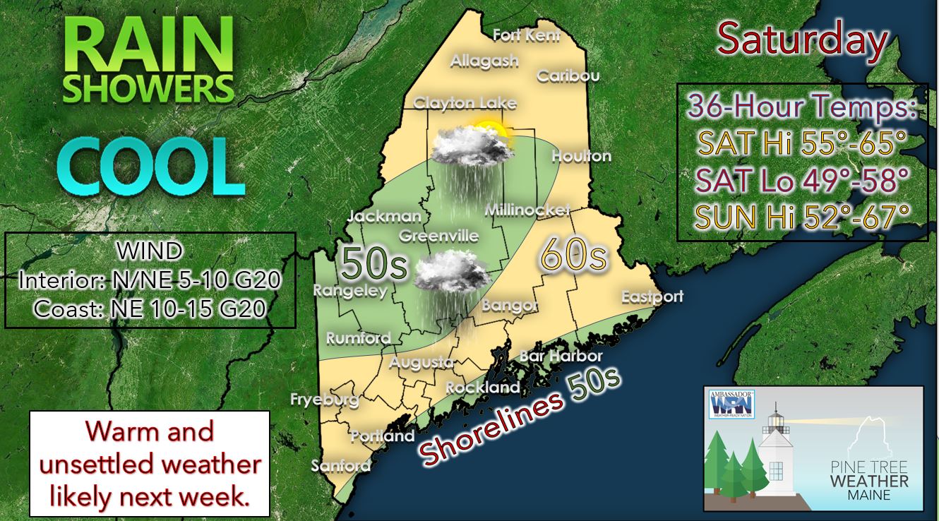
Saturday looks to be yet another unsettled and chilly day across much of the state.  This is due to a surface low passing near Cape Cod on Saturday and moving offshore to the northeast past our region. High temperatures are expected to be chilly for this time of year with upper 50’s to mid-60’s expected statewide. High temperatures in the 50’s are favored over the higher elevations of western Maine and for the immediate coastal locations. Skies will be overcast throughout the day across the state with rain showers likely. The rain showers are likely to be more widespread over the southern half of the state Saturday.  

​Saturday night we can expect mostly cloudy skies across the state as the upper low moves off to the northeast. There could be some leftover shower activity primarily in Downeast Maine for the overnight. Low temperatures should be in the upper 40’s to mid-50's. 

Independence Day should start off mostly cloudy to overcast across the state with morning showers likely. As an upper-level disturbance moves away from our area throughout the course of the day, we should see skies turn partly to mostly cloudy by the evening. High temperatures on Sunday are expected to be in the low to mid-60’s across the southern half of the state with 50’s likely for the mountains and for the shoreline locations. If you are thinking of watching or setting off your own fireworks for the Fourth of July, conditions shortly after sunset will likely be mostly cloudy with isolated showers and temperatures in the upper 50’s to lower 60’s for many.  

Sunday night we should see low temperatures ranging from the upper 40’s to mid-50's across the state with partly to mostly cloudy skies expected.  

High pressure begins to approach our area on Monday making it likely the nicest day of the holiday weekend. Expect high temperatures to be seasonable with temperatures in the mid to upper 70’s across much of the state. Skies are expected to be partly to mostly sunny. There could be the chance of a few isolated thundershowers across the state Monday. 

Tuesday and Wednesday we will likely see the return of above average temperatures as well as increased humidity.  Tuesday expect high temperatures potentially in the 80’s and lower 90’s, especially across the southern half of the state. For Wednesday, we could see another warm day; however, there likely will be a front over our area making high temperatures hard to predict at this time. With the front in the area, we will likely be unsettled heading into the middle and later half of the upcoming week with chances for showers and thunderstorms. 

Be prepared to receive alerts and stay updated!

Picture
​​​​BE PREPARED WITH A NOAA Weather Radio.
​
​For $20-$40, it could provide vital information to you when you need it. The weather bands are standard on most public safety scanners, and newer scanner models. Weather radios can be programmed for auto alert. Click here for more information.

​► ► For the latest official forecasts, bulletins, and advisories, please check in with the National Weather Service in Gray for western and southern areas, or Caribou for northern and eastern parts of Maine.
Picture

Picture
Thank you for your support!

Madelyn will have an update for you on Facebook tomorrow.
​
- Aidan
​
​Find me on Twitter

For more information in between posts, please follow Pine Tree Weather on Facebook and Twitter. 

​Thank you for supporting this community-based weather information source which operates by reader supported financial contributions. 

Stay updated, stay on alert, and stay safe!
Comments
    Picture

    Mike Haggett
    Kennebunk, ME

    Weather-Ready Nation
    Ambassador

    Certified Weather
    Forecaster
    Penn State '21

    American Meteorological Society

    National Weather Association
    ​
    ​SKYWARN-CWOP

    Matthew 19:26


    DONATE

    Picture
    Picture
    Picture
    Picture
    Picture

    Picture

    Picture

    Picture

    Picture

    Picture

    Picture

    Picture

    Picture

    Picture

    Picture

    Picture

    Picture


    Archives

    April 2025
    March 2025
    February 2025
    January 2025
    December 2024
    November 2024
    October 2024
    September 2024
    August 2024
    July 2024
    June 2024
    May 2024
    April 2024
    March 2024
    February 2024
    January 2024
    December 2023
    November 2023
    October 2023
    September 2023
    August 2023
    July 2023
    June 2023
    May 2023
    April 2023
    March 2023
    February 2023
    January 2023
    December 2022
    November 2022
    October 2022
    September 2022
    August 2022
    July 2022
    June 2022
    May 2022
    April 2022
    March 2022
    February 2022
    January 2022
    December 2021
    November 2021
    October 2021
    September 2021
    August 2021
    July 2021
    June 2021
    May 2021
    April 2021
    March 2021
    February 2021
    January 2021
    December 2020
    November 2020
    October 2020
    September 2020
    August 2020
    July 2020
    June 2020
    May 2020
    April 2020
    March 2020
    February 2020
    January 2020
    December 2019
    November 2019
    October 2019
    September 2019
    August 2019
    July 2019
    June 2019
    May 2019
    April 2019
    March 2019
    February 2019
    January 2019
    December 2018
    November 2018
    October 2018
    September 2018
    August 2018
    July 2018
    June 2018
    May 2018
    April 2018
    March 2018
    February 2018
    January 2018
    December 2017
    November 2017
    October 2017

Proudly powered by Weebly