Pine Tree Weather
  • DISCUSSIONS
  • DONATE
  • WEATHER WALL
  • MAPS
  • RAIN OUTLOOK
  • SEVERE
  • MARINE
  • CPC OUTLOOK
  • Kennebunk
  • MY BIO
  • PTW IN MEDIA
  • OBSERVING WEATHER
  • INTERNSHIPS
  • INTERN ALUMNI
  • DISCUSSIONS
  • DONATE
  • WEATHER WALL
  • MAPS
  • RAIN OUTLOOK
  • SEVERE
  • MARINE
  • CPC OUTLOOK
  • Kennebunk
  • MY BIO
  • PTW IN MEDIA
  • OBSERVING WEATHER
  • INTERNSHIPS
  • INTERN ALUMNI

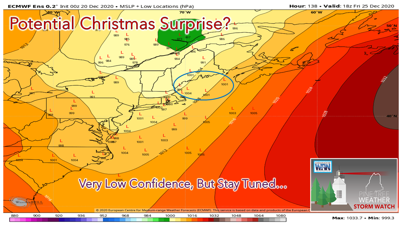
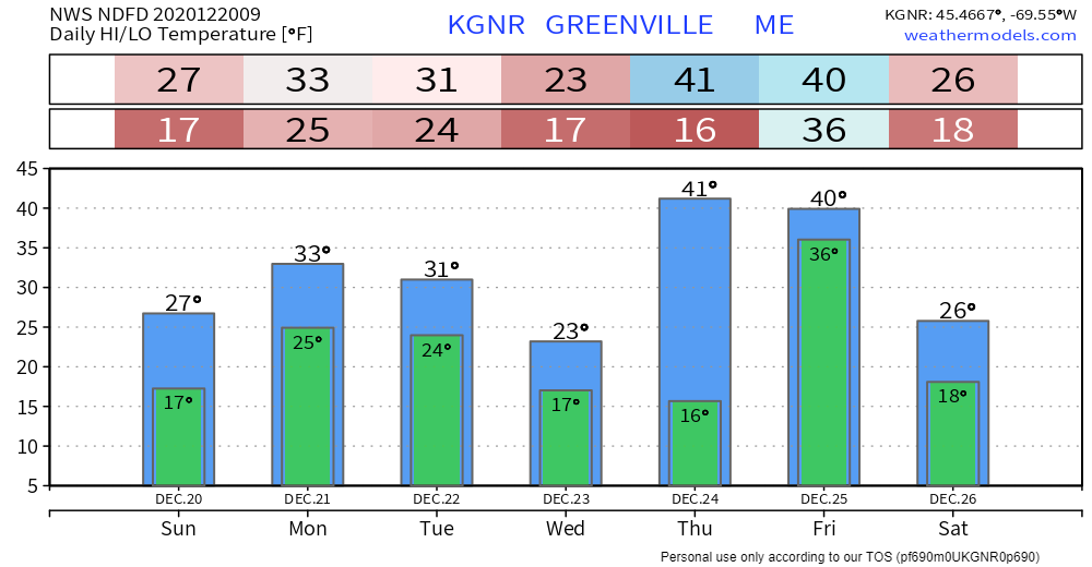
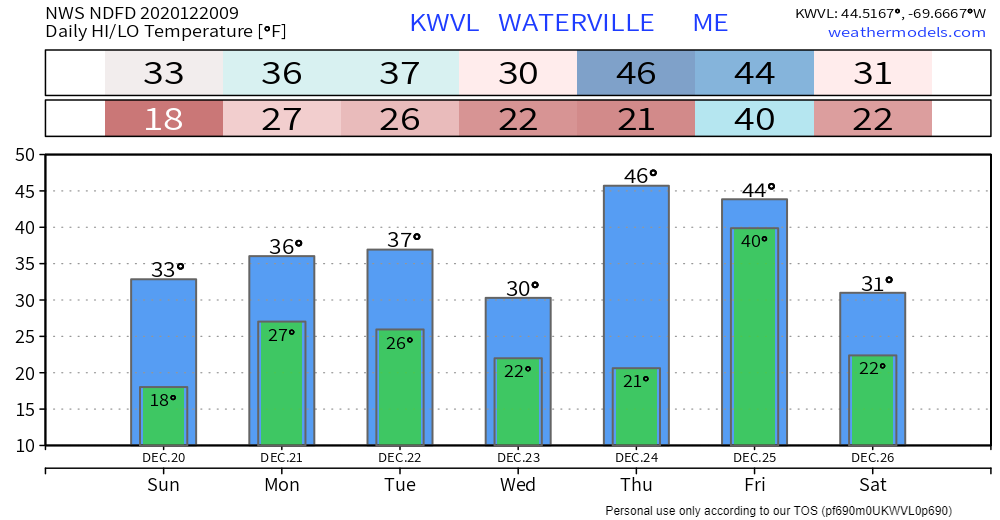
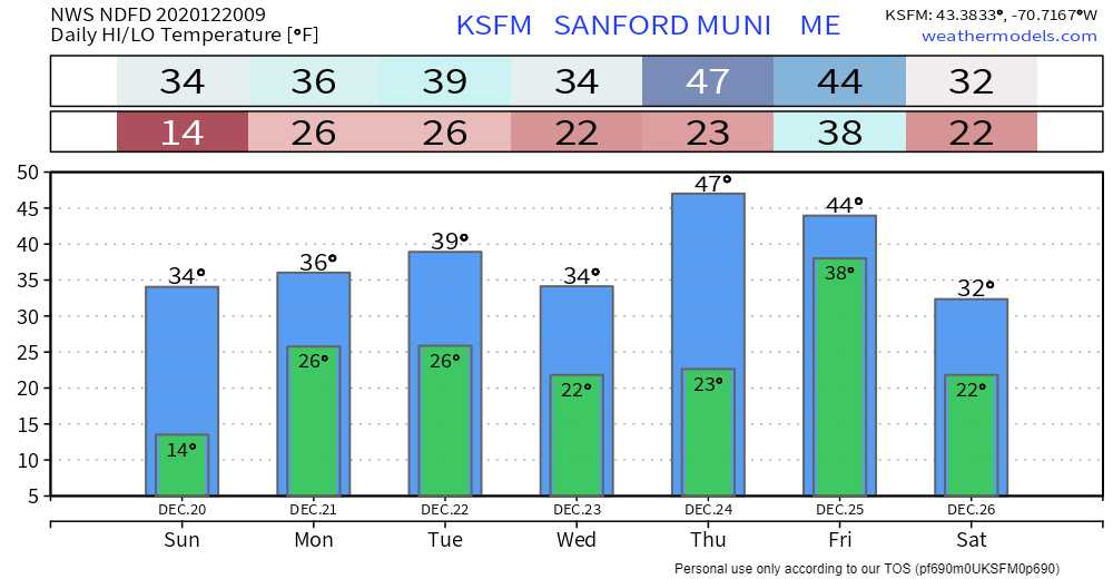
Slick spots possible Sunday night into Monday, close shave for Monday night, Christmas update

12/20/2020

Comments

 
Picture

Catch the rays if you can Sunday

Picture
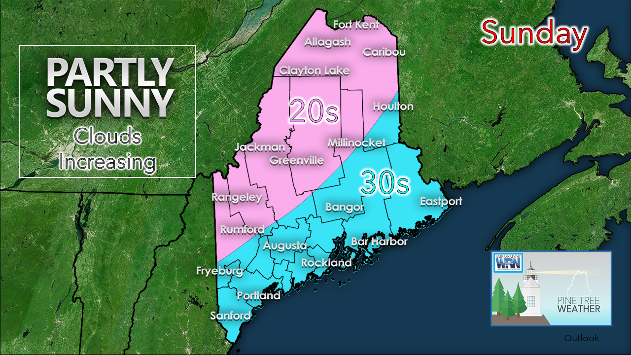
A bit warmer for the day. Wind is generally light away from the coast. A southerly breeze ahead of the weak frontal boundary approaching the region may raise speed in the 10-15 mph along the beaches in the afternoon.
Picture
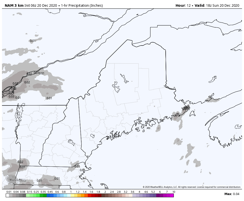
NAM model idea of 1-hour liquid equivalent precipitation from 1 PM Sunday to 7 AM Monday
Southwestern areas may catch a brief rain / mix or snow shower later in the afternoon. Front passes through the region overnight and ends over northern and eastern areas around daylight Monday. 
Picture
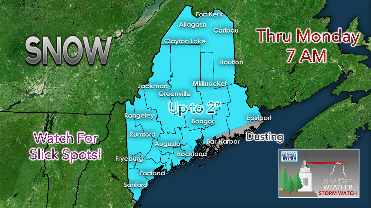
Some areas may not get any accumulation. I do have a bit of concern for some ocean enhancement for Portland areas east, which accounts for a slight raise in snow totals. Expect some slick travel in spots Monday morning. 

Close call for snow for eastern areas Monday Night

Picture
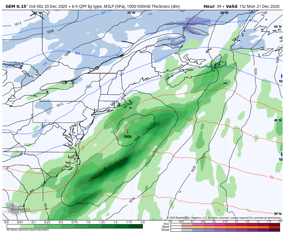
GEM model idea of surface pressure and precipitation from 10 AM Monday to 7 PM Tuesday
I've mentioned this offshore frontal boundary in my previous updates in regards to Monday night. Quite frankly, I am still a bit concerned about it. Most guidance is a bit more progressive with the position of the front and storm initiation to affect the Canadian Maritimes. This GEM model idea is the outlier, showing a slight delay in the forward progress of the front. I am not one that likes surprises very much when it comes to snowfall especially, so I am throwing this idea out there as a possibility that eastern areas could pick up an inch or two of snow Monday night into early Tuesday. 

If the rest of the model ideas are correct, the eastern shorelines may get a slight brush of snow showers or flurries, and that would be it. 

A sloppy wet kiss likely for Christmas,
​but there is a slight chance it could turn colder

Picture
European model idea of precipitable water content from 1 AM Thursday to 7 PM Saturday
I want to define this loop here by saying this is an idea of the amount of precipitable water in the air column, NOT rainfall amounts. I present this idea to show the amount of atmospheric moisture associated with the storm that is on the way for Christmas. 

In a nutshell, this is typical of what we see in July.
Picture
For this time of the year, it's seriously abnormal. Anomalous values could exceed higher than 400% of normal. This storm is very rich in moisture and has tropical characteristics. As a result, heavy rain, thunderstorms, potential for localized flash flooding, urban street flooding, ponding on roadways, fog, and gusty south/southeast wind which could bring power outages are all on the table for this event. 

Ensemble ideas are looking at 1-1½" of rain likely at this point. That is a good starting point, and if ideas hold together, amounts could double that in places, especially the mountains.
Picture
GEM model idea of surface pressure and precipitation from 7 PM Wednesday to 7 AM Saturday
Timing as of Sunday morning appears that some outflow showers are possible in the afternoon for southern areas Christmas Eve Thursday, but the main slug of moisture works through Christmas Day Friday, ending overnight into Saturday morning.

BE ADVISED that the temperatures fall below freezing behind the system and everything will FREEZE UP overnight Christmas night into Saturday morning. There is flash-freeze potential on the backside of this, but it's too early to nail that down just yet. Between the rain and run off from melting, Saturday morning could be skating rink across the entire state.

For those in ski country looking for a glimmer of hope that the precipitation type changes to a more frozen variety, I will present this...
Picture
If low pressure forms over the Gulf of Maine along this front heading into Christmas Day, it could effectively shut down the warm air aloft and turn in colder, which would mean snow. I will say this idea is remote, and the chances are very slim, but it is not a slam dunk that this storm stays wet through duration. 

Special thanks to William Watson at NWS Gray for pointing this idea out. 

Picture

Temperature outlook through Saturday

A roller coaster ride on temperatures through the week. Typical high and low for northern Maine is 25° and 9°. For southern areas, 36° and 19°. Temperatures will run generally above normal everywhere through the week ahead. 
Picture
Picture
Picture
Picture
Picture

Be prepared to receive alerts and stay updated!

Picture
​BE PREPARED WITH A NOAA Weather Radio.

​For $20-$40, it could provide important information to you when you need it. The weather bands are standard on most public safety scanners, and newer scanner models. Weather radios can be programmed for auto alert.  Click here for more information.

​► ► For the latest official forecasts, bulletins and advisories, please check in with the National Weather Service in Gray for western and southern areas, or Caribou for northern and eastern parts of Maine
Picture

For more information, please follow Pine Tree Weather on Facebook and Twitter. 

** FUNDING NEEDED FOR 2021 **
​Thank you for supporting this community based weather information source that is funded by your financial contributions. 


Stay updated, stay on alert, and stay safe!

​- Mike
Comments
    Picture

    Mike Haggett
    Kennebunk, ME

    Weather-Ready Nation
    Ambassador

    Certified Weather
    Forecaster
    Penn State '21

    American Meteorological Society

    National Weather Association
    ​
    ​SKYWARN-CWOP

    Matthew 19:26


    DONATE

    Picture
    Picture
    Picture
    Picture
    Picture

    Picture

    Picture

    Picture

    Picture

    Picture

    Picture

    Picture

    Picture

    Picture

    Picture

    Picture

    Picture


    Archives

    April 2025
    March 2025
    February 2025
    January 2025
    December 2024
    November 2024
    October 2024
    September 2024
    August 2024
    July 2024
    June 2024
    May 2024
    April 2024
    March 2024
    February 2024
    January 2024
    December 2023
    November 2023
    October 2023
    September 2023
    August 2023
    July 2023
    June 2023
    May 2023
    April 2023
    March 2023
    February 2023
    January 2023
    December 2022
    November 2022
    October 2022
    September 2022
    August 2022
    July 2022
    June 2022
    May 2022
    April 2022
    March 2022
    February 2022
    January 2022
    December 2021
    November 2021
    October 2021
    September 2021
    August 2021
    July 2021
    June 2021
    May 2021
    April 2021
    March 2021
    February 2021
    January 2021
    December 2020
    November 2020
    October 2020
    September 2020
    August 2020
    July 2020
    June 2020
    May 2020
    April 2020
    March 2020
    February 2020
    January 2020
    December 2019
    November 2019
    October 2019
    September 2019
    August 2019
    July 2019
    June 2019
    May 2019
    April 2019
    March 2019
    February 2019
    January 2019
    December 2018
    November 2018
    October 2018
    September 2018
    August 2018
    July 2018
    June 2018
    May 2018
    April 2018
    March 2018
    February 2018
    January 2018
    December 2017
    November 2017
    October 2017

Proudly powered by Weebly