Pine Tree Weather
  • DISCUSSIONS
  • MAPS
  • BRIEFINGS
  • SATRAD
  • MARINE
  • RAIN OUTLOOK
  • SNOW / ICE OUTLOOK
  • CPC OUTLOOK
  • Kennebunk
  • Weather Geekdom
  • Who We Are
  • DONATE
  • My Photography
  • DISCUSSIONS
  • MAPS
  • BRIEFINGS
  • SATRAD
  • MARINE
  • RAIN OUTLOOK
  • SNOW / ICE OUTLOOK
  • CPC OUTLOOK
  • Kennebunk
  • Weather Geekdom
  • Who We Are
  • DONATE
  • My Photography

Snow and rain off and on in areas through the week

3/8/2020

Comments


Odds & Ends of news

Picture
Goose Rocks Beach, Kennebunk March 7, 2020 - Pine Tree Weather photo
We're into spring now so that means flood potential.  For the western half of Maine, the flood threat discussion posted by the Gray weather office indicated a below normal threat for York County and normal for the rest of the region. For the eastern half of the state, the flood threat discussion posted by the Caribou weather office shows a slightly above normal threat for the Allagash region and normal through the DownEast coast.  If you live near a flood prone area or commute in areas that are flood prone, it's important to stay up to date with any bulletins in regards to flooding from the National Weather Service. 

I am concerned for the fire threat for southwestern areas along with the shoreline towns up and down the coast as the snowpack continues to reduce. Foliage will be slow to come in. Dry grass with a little wind is easy fuel for fire danger. While it is enticing to clean the yard and burn off limbs and leaves, please check with your local fire department or forest ranger for guidance prior to lighting it off. Please dispose of smoking materials responsibly.

NEW FORECAST ZONE: Interior Cumberland Highlands for those that live in the Sebago, Naples, Casco, Harrison and Bridgton areas has been created by the Gray weather office and went live at noon on March 3rd. This region now has its own specific forecast, watch, warning and fire weather zone. For those that live in that region, this is long overdue, and will provide better accuracy for that region into the future. 

Stalled front to cause a snowy mess
​for the north through midweek

Picture
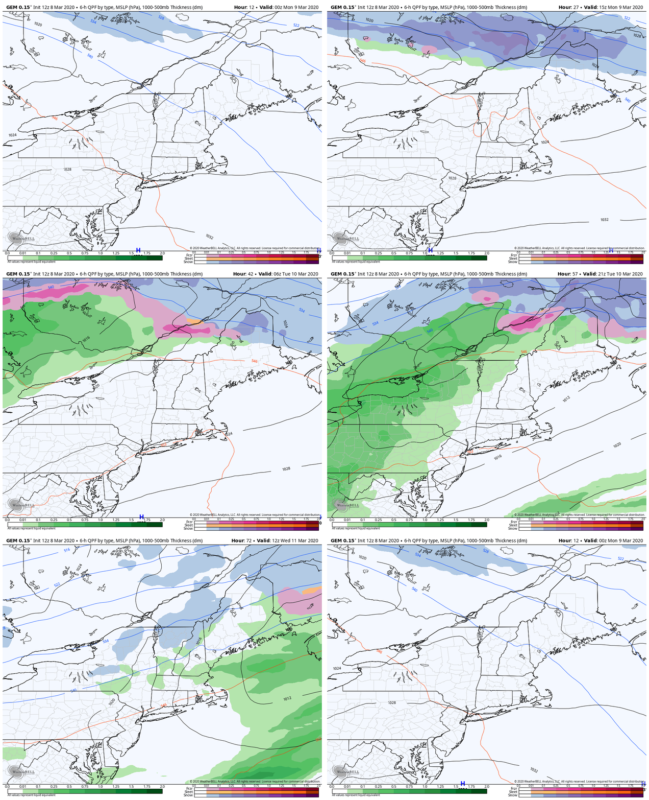
High pressure slides to the southeast Sunday night. A frontal boundary stalls over northern Maine, which will keep much of The County cool and bring well above normal temperatures to southern areas through midweek. Snow showers persist through northern areas through Monday. As the front sags to the south, snow and/or rain showers and mixed precipitation Tuesday becomes more numerous over the north country. Tuesday night, all areas have a chance for some sort of precipitation, mainly rain for most, as the frontal boundary finally exits offshore Wednesday morning.
Picture
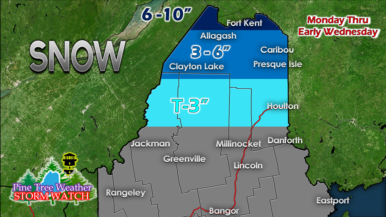
The further north, the better the chance for heavier snow. I can't rule out a few flakes for the Jackman-Greenville-Millinocket-Danforth region late Monday night into Tuesday, but the plowable amounts should stay to the north. Expect two days of slick travel for much of the north country.

Snow and/or rain potential late week

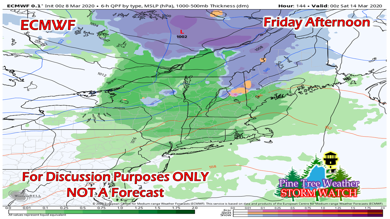
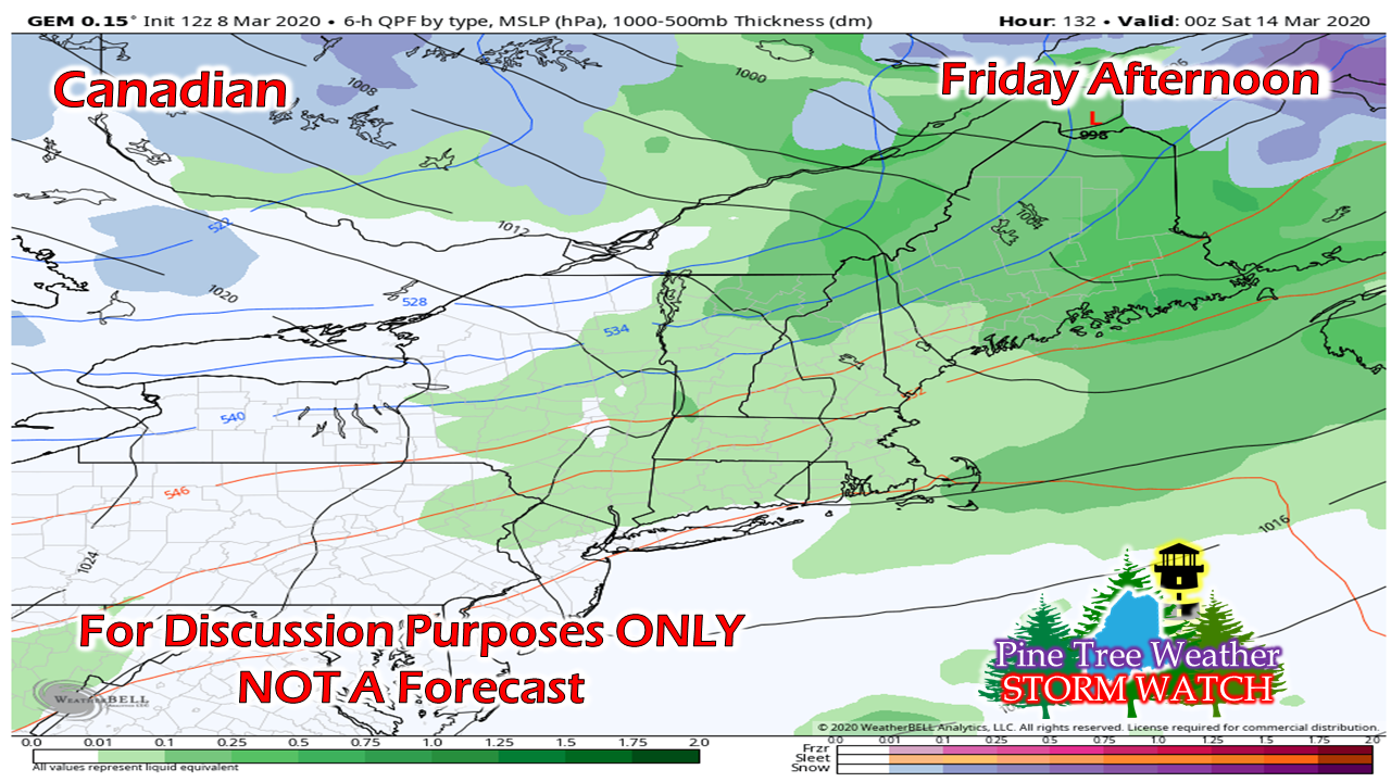
​Interior areas should pay attention to the forecast as the week unfolds in regards to Friday into early Saturday. The jury is still out on whether this will be a snow to rain event for interior areas, or all rain. 
Picture
The European is definitely the cooler idea. In this case, a plowable event is possible for western and northern areas, with rain as the potential parting gift. 
Picture
The Canadian is a bit warmer, and brings a mainly rain scenario. This is one of those situations that is common in spring for the interior where temperatures range in the mid-30s and with enough warm air advection to make it an all rain or rain with areas of freezing rain. Models are scattered in output, so stay tuned on what happens here. 

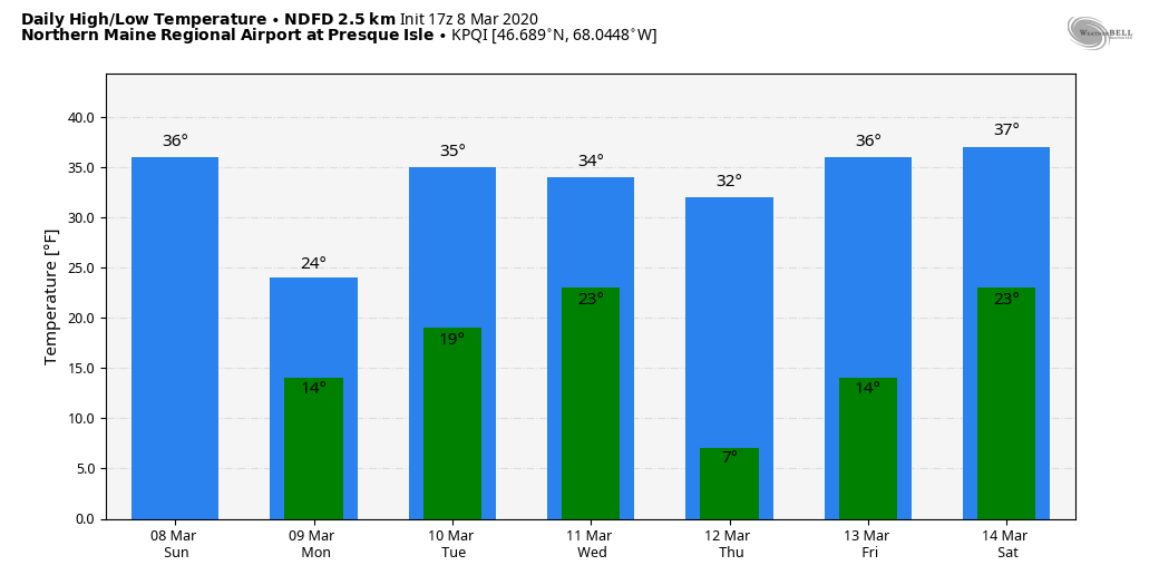
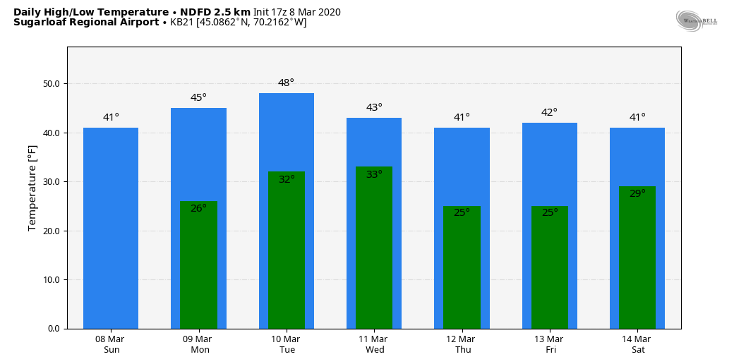
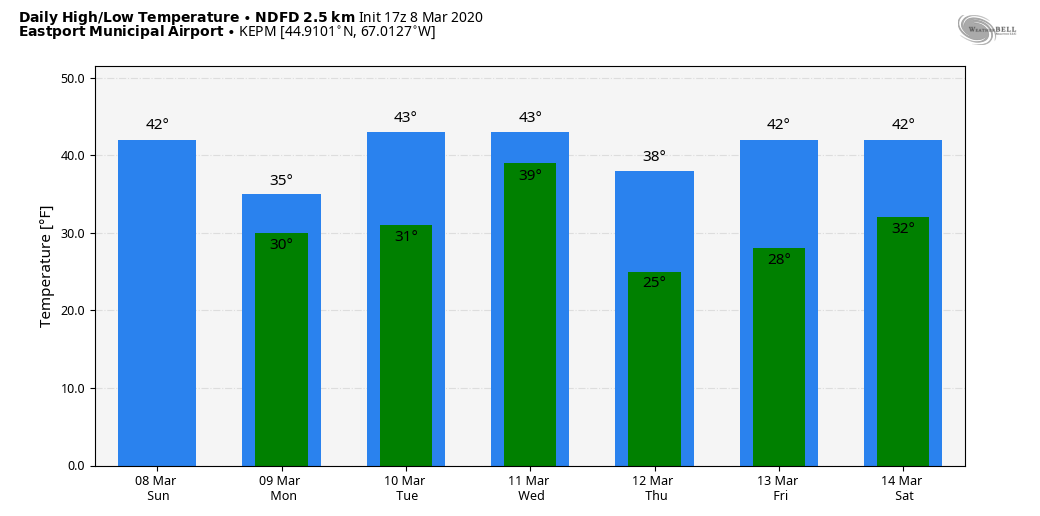
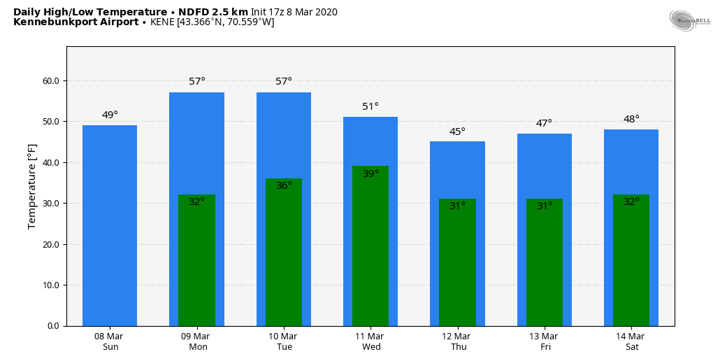
Temperature outlook through Saturday

All four regions in the outlook. First for Presque Isle, temperatures generally continue above normal through the week, with Monday being the closest to normal. 
Picture
For you Sugarloafers, it's a great week for spring conditions. Most nights fall back below freezing, which means the guns can keep the base fresh.
Picture
For Eastport, mid to upper 30s to the mid 40s appears to be the rule for the week. Wind looks reasonable through the period, although Friday's storm may bring the breeze up. 
Picture
For the southwest coast, 40s and 50s appear the rule (low 60s Monday and Tuesday would not surprise me from Kennebunk south) with most overnight lows staying above freezing. 
Picture
Thanks for hanging in there with me this week as I have dealt with illness, school, and work. I am grateful for your understanding and support.

► ► For the latest official forecasts, bulletins and advisories, please check in with the National Weather Service in Gray for western and southern areas, or Caribou for northern and eastern parts of Maine.

You can help keep Pine Tree Weather going into the future with a donation of ANY amount now through VENMO @PineTreeWeather, a monthly donation on Patreon or messaging me on Facebook or Twitter to send a check in the mail. Thank you for your support!

Always stay weather aware!

​- Mike
Comments
    Picture

    Mike Haggett
    Kennebunk, ME

    Penn State
    Weather Forecast Certification '21.
    AMS / NWA
    Weather-Ready Nation 
    ​SKYWARN-CWOP

    Picture

    Alex Hatfield
    Wakefield,MA


    Penn State
    Meteorology and Atmospheric Science ‘21
    PSUBAMS
    Campus Weather Service
    PSU Storm Chase Team
    PSU College of Earth &  Mineral Sciences Ambassador

    Picture

    Kaitlyn Lardeo
    ​Syracuse, NY

    SUNY Oswego
    Atmospheric Science
    Lake Effect Storm Prediction and Research Center
    Northeastern Storm Conference Contributor

    DONATE
    Picture

    Archives

    January 2021
    December 2020
    November 2020
    October 2020
    September 2020
    August 2020
    July 2020
    June 2020
    May 2020
    April 2020
    March 2020
    February 2020
    January 2020
    December 2019
    November 2019
    October 2019
    September 2019
    August 2019
    July 2019
    June 2019
    May 2019
    April 2019
    March 2019
    February 2019
    January 2019
    December 2018
    November 2018
    October 2018
    September 2018
    August 2018
    July 2018
    June 2018
    May 2018
    April 2018
    March 2018
    February 2018
    January 2018
    December 2017
    November 2017
    October 2017

    Categories

    All
    Maine Weather
    Pine Tree Weather

    RSS Feed

Proudly powered by Weebly