
Plan on slick travel starting Thursday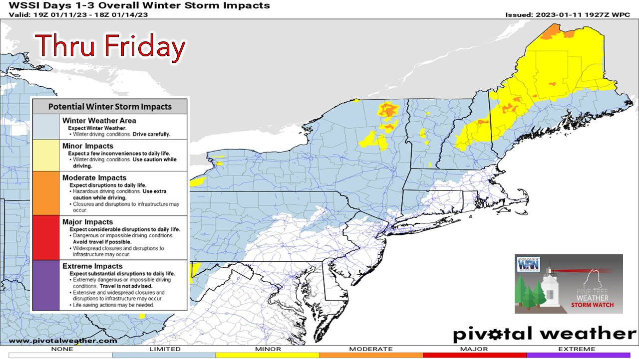 The Winter Storm Severity Index issued by the Weather Prediction Center shows minor to moderate impacts for interior areas of Maine as travel is expected to be tricky at times until conditions warm up above freezing. For those on the roads, allow for plenty of extra time to reach you destination(s) and plan accordingly.  A Winter Weather Advisory is posted away from the immediate coast over southwestern areas, and for southern Piscataquis, central Penobscot, and northern Washington Counties. A Winter Storm Watch is posted for the northern tier. If you think the ideas have trended cooler, that is correct, especially over the north. Timing, precipitation type, and windFor those that read yesterday's update will remember that I had concerns about model ideas handling the freezing rain aspect of the storm. I have been patiently waiting for guidance to catch on and it is starting to. The trend is a bit cooler due to the fact the wind from the southeast is a bit slower to move in due to a slightly weaker system. 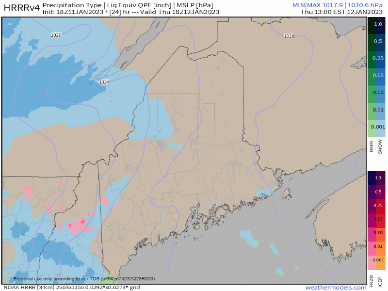 Thursday 1 PM to Friday 1 AM - Areas of ocean effect snow showers are possible over the shorelines Thursday morning. As we head into the afternoon, snow picks up with intensity as the storm tracks northeastward. As the wind begins to pick up out of the southeast, it begins to push warm air inland. The signatures of cold air damming are duly noted with the isobars indicating barometric pressure with the southwest direction. This is where it gets interesting heading into Thursday night as the coastal front runs up against it and may create areas of wet snow and slop along it which may accumulate an inch or two over the MidCoast and points along the DownEast shorelines before flipping to rain as warm air gets superiority. Areas of sleet and freezing rain are also expected as the atmosphere becomes rather constipated with the battle between the cold and warm air. Precipitation becomes heavier as the hose of moisture streams into southern areas Thursday night. As far as junk storms (mixed precipitation) go, this isn't as junky as we've seen lately, which doesn't offend anyone. 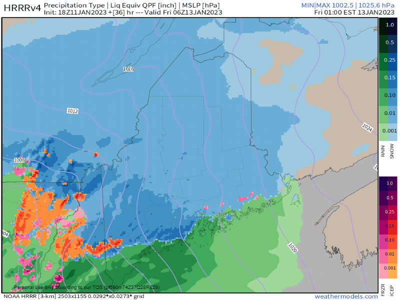 Friday 1 AM to Friday 1 PM - Heading into Friday morning is when the forecast becomes a bit tricky. The warm air continues to surge inland, but the cold air at the surface won't go away without a fight. It will lose eventually as the storm tracks into the Eastern Townships of Quebec which with a moderate low level jet will be strong enough to wash the stubborn cold out. The question I continue to have is when that is going to happen. For those in the western foothills and the mountains, it may be mid to late morning before the change comes. Those in well protected areas from the southeast wind (north and west of the Bigelow's, Rangeley area) may see freezing rain hang on longer. As the storm continues to the northeast, areas seeing snow may get a bit of a mix before changing to rain. Heavier precipitation ends Friday afternoon with pockets of light rain showers and drizzle over the south, east, and west, and Friday evening over the north. The cold front passes through will perhaps a rain and/or snow shower, but exits with little fanfare. Temperatures are expect to slowly fall Friday night. I am not expecting any flash freezing concerns, but there could be some icy spots Saturday morning where puddles and areas of standing water freeze up. 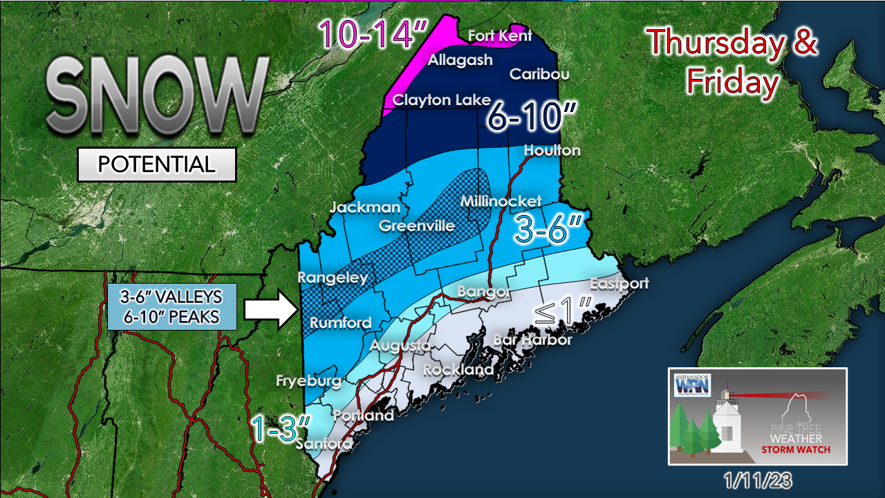 More cold hanging on in the north means more snow there. The higher elevation ski hills get out of this in the plus column with little impact from rain or melting. Friday will be a fun day on the slopes. For those curious, Katahdin may get upwards of two feet of snow out of this. 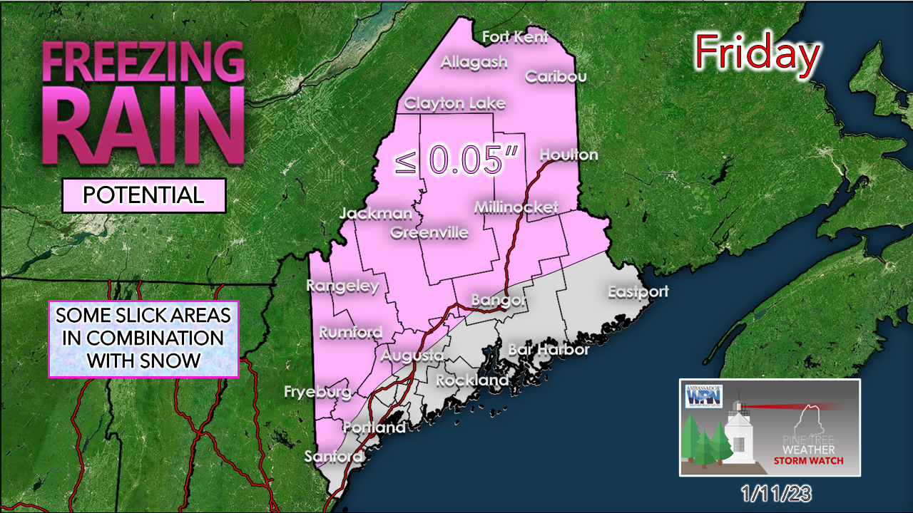 Ice isn't going to be a big deal, and with the rise in temperatures, it will melt. Well protected areas may get upwards of a tenth of an inch, maybe a bit more, before the warm air arrives. 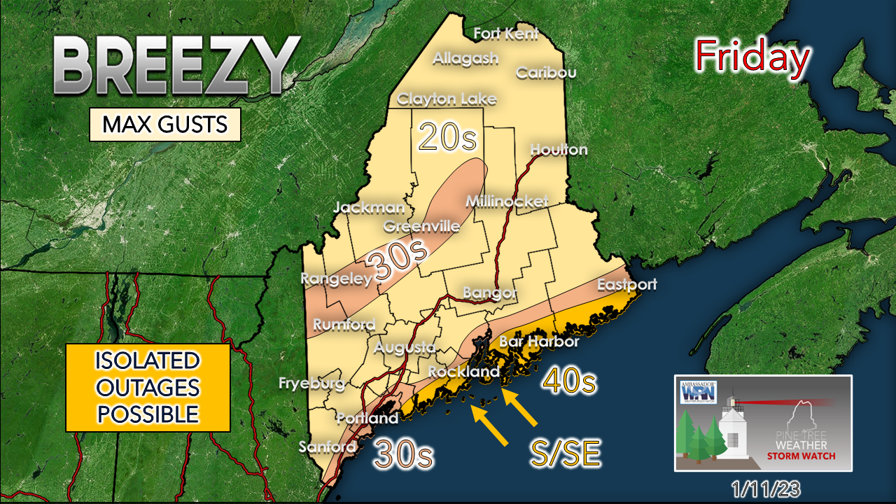 The wind idea remains the same. MidCoast areas from Phippsburg to Eastport may see gusts in the 40-50 mph range. The mountains, southwest coast and coastal interior areas may see peak wind in the 30-40 mph range. For most areas of the interior, 20-30 mph is the max. Where the wind is strongest is where the threat for power outages come, and that for now appears minimal. Folks over interior areas that see snow sticking to trees and power lines should stay mindful that as the temperature increases that the frozen precipitation will melt off. The peak winds will have passed by 1-3 PM Friday west of Penobscot Bay and by 7-10 PM for eastern areas. 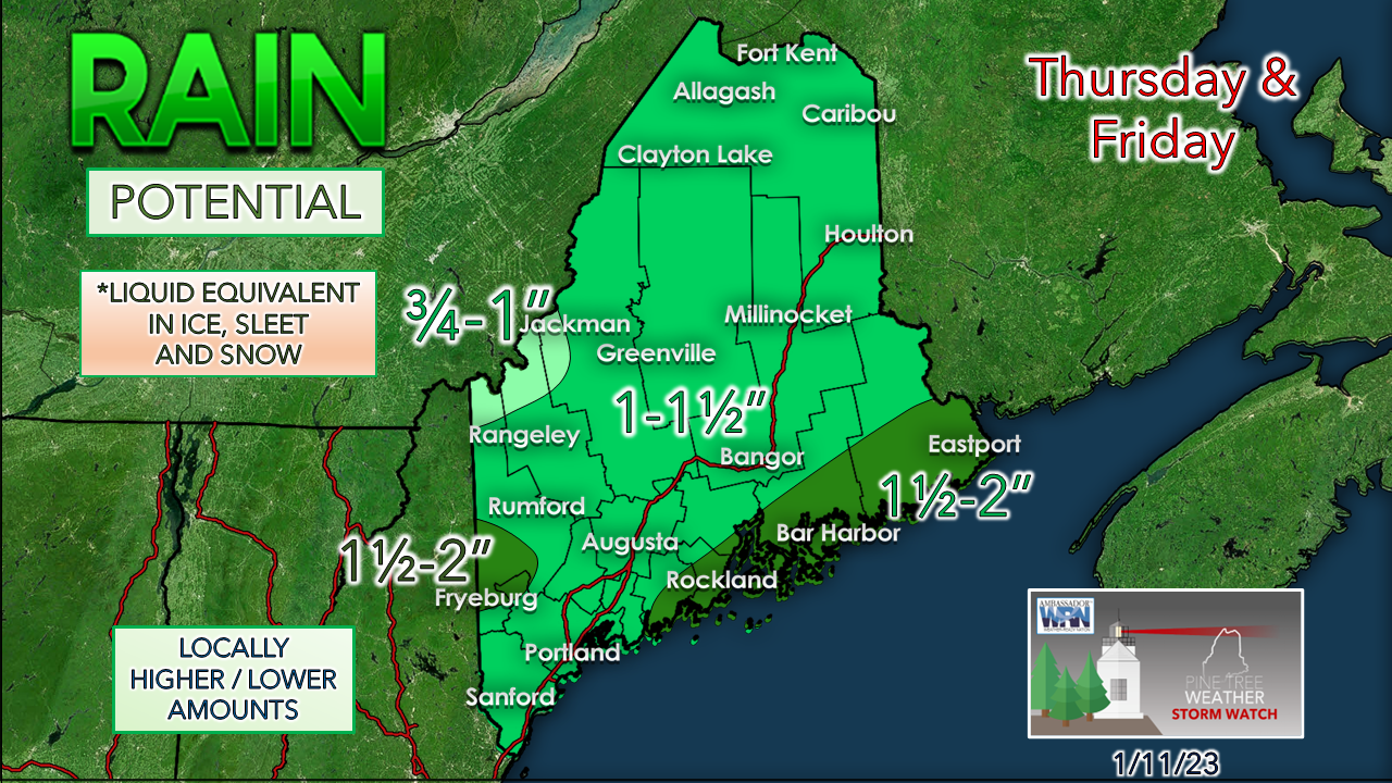 Flooding concerns are minimal with this event. There may be some localized run off that may bring areas of standing water and minor flooding in poor drainage areas due to the ground being frozen. The shorelines escape without too much issues. Seas are expected to reach the 7-10 foot range in exposed areas. High tide is in the 3 PM Friday timeframe and may bring some splash-over and some minor erosion, and that is about it. Temperature and outlook through MondayHigh pressure moves in for Saturday and dominates the pattern through Monday, with most areas void of precipitation. The next chance for precipitation comes Tuesday, and may come in the form of a backdoor cold front as a traffic jam develops over the Atlantic to the east. 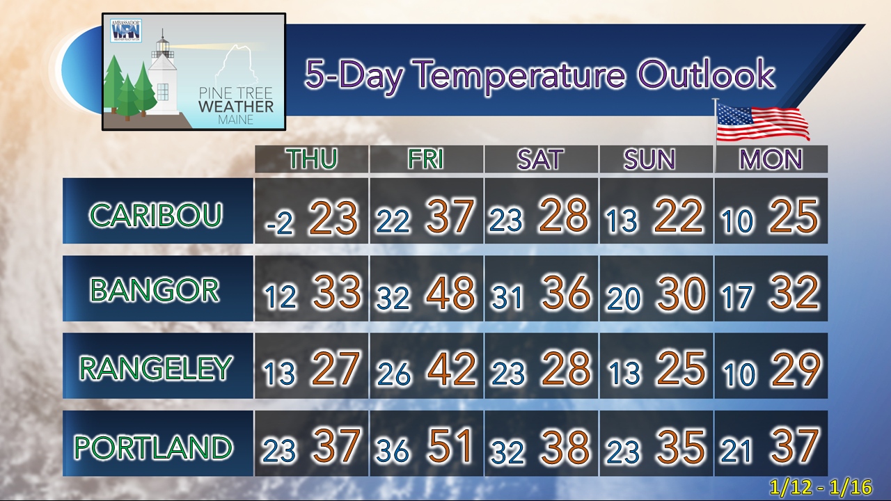 Thank you as always for your support! You may not like the weather, but I hope you like what I do! Please hit the like button on Twitter and Facebook, and share! Financial donations to fund what I do are always appreciated! Stay updated, stay on alert, and stay safe! - Mike NOTE: The forecast information depicted on this platform is for general information purposes only for the public and is not designed or intended for commercial use. For those seeking pinpoint weather information for business operations, you should use a private sector source. For information about where to find commercial forecasters to assist your business, please message me and I will be happy to help you. |

Mike Haggett
|


