Pine Tree Weather
  • DISCUSSIONS
  • DONATE
  • MAPS
  • NWS BRIEFINGS
  • SATRAD
  • MARINE
  • SNOW / ICE OUTLOOK
  • RAIN OUTLOOK
  • CPC OUTLOOK
  • Kennebunk
  • OBSERVING WEATHER
  • Who We Are
  • My Photography
  • DISCUSSIONS
  • DONATE
  • MAPS
  • NWS BRIEFINGS
  • SATRAD
  • MARINE
  • SNOW / ICE OUTLOOK
  • RAIN OUTLOOK
  • CPC OUTLOOK
  • Kennebunk
  • OBSERVING WEATHER
  • Who We Are
  • My Photography

Snow possible to start the week

12/16/2017

Comments


The remainder of the weekend appears quiet

Outside of a few isolated snow showers around on Saturday, the rest of the weekend appears void of any precipitation. Sunday will be the better sky day of the two with more sun than clouds. Temperatures remain on the cool side of this time of year. It will be a good weekend to travel about and continue to prepare for the holidays.

Monday and Tuesday to bring some precipitation

Picture
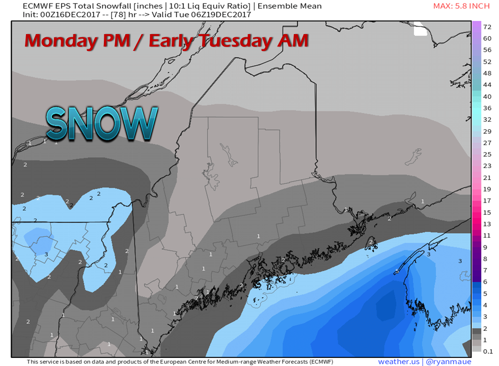
In this part of the post I am strictly talking potential. The chart above of the European ensemble run to this point is a clear outlier as compared to the other guidance. This overnight model suite has increased potential for a scrapeable snow for the coast to start the week. A piece of upper level energy associated with a frontal boundary crosses the region Monday afternoon into early Tuesday, and the Euro is a bit hot with it. I don't like surprises with snow events, so I wanted to pass this along. This could be nothing but light snow showers as the NAM, GFS and Canadian models suggest, but I am not quick to dismiss this idea.
Picture
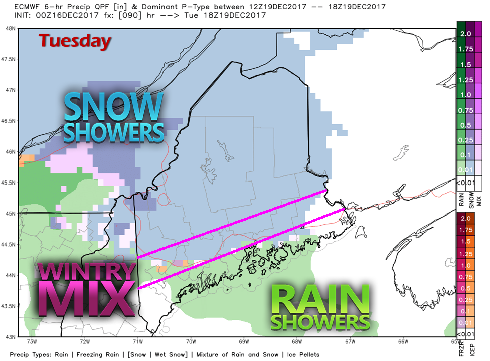
Guidance is in fair agreement with what will happen on Tuesday. A warm front noses in from the southwest and could bring snow for the north and mountains, a mix for the foothills and coastal interior, and rain showers along the coast. This does not appear to be a big precipitation event, and is possible to be more of a nuisance than anything else.

After a cold front sweeps through Tuesday night, snow showers are possible for the mountains and north during the day Wednesday. High pressure takes over Thursday, with a storm possible to start the holiday weekend. 

The 5-Day Outlook page has been updated. Please click on the link above to get you there.

​- Mike 
Comments
    Picture

    Mike Haggett
    Kennebunk, ME

    Certified Weather
    Forecaster
    Penn State '21

    American Meteorological Society

    National Weather Association

    Weather-Ready Nation 
    Ambassador
    ​
    ​SKYWARN-CWOP

    Matthew 19:26


    Support
    Pine Tree Weather

    DONATE

    Picture

    Picture

    Picture

    Picture

    Picture

    Picture

    Picture

    Picture

    Picture

    Picture

    Archives

    January 2023
    December 2022
    November 2022
    October 2022
    September 2022
    August 2022
    July 2022
    June 2022
    May 2022
    April 2022
    March 2022
    February 2022
    January 2022
    December 2021
    November 2021
    October 2021
    September 2021
    August 2021
    July 2021
    June 2021
    May 2021
    April 2021
    March 2021
    February 2021
    January 2021
    December 2020
    November 2020
    October 2020
    September 2020
    August 2020
    July 2020
    June 2020
    May 2020
    April 2020
    March 2020
    February 2020
    January 2020
    December 2019
    November 2019
    October 2019
    September 2019
    August 2019
    July 2019
    June 2019
    May 2019
    April 2019
    March 2019
    February 2019
    January 2019
    December 2018
    November 2018
    October 2018
    September 2018
    August 2018
    July 2018
    June 2018
    May 2018
    April 2018
    March 2018
    February 2018
    January 2018
    December 2017
    November 2017
    October 2017

    RSS Feed

Proudly powered by Weebly