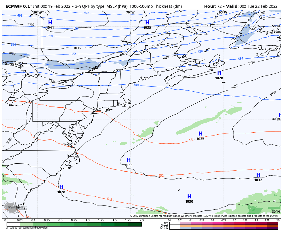
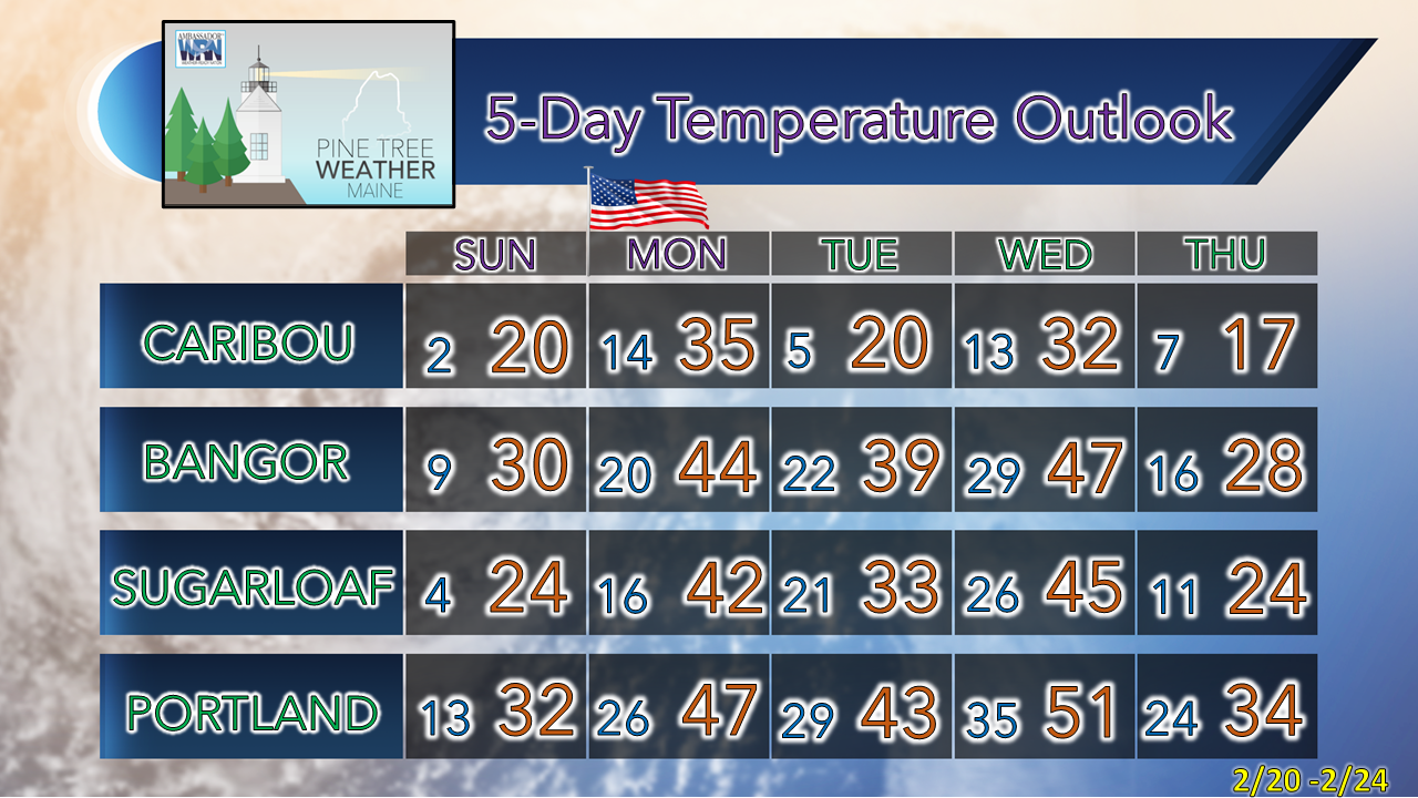
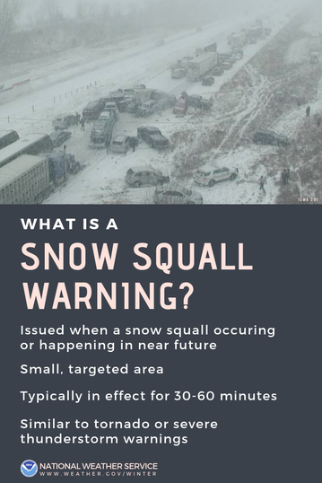
Pine Tree Weather
  • DISCUSSIONS
  • DONATE
  • MAPS
  • NWS BRIEFINGS
  • SATRAD
  • MARINE
  • SNOW / ICE OUTLOOK
  • RAIN OUTLOOK
  • CPC OUTLOOK
  • Kennebunk
  • OBSERVING WEATHER
  • Who We Are
  • My Photography
  • DISCUSSIONS
  • DONATE
  • MAPS
  • NWS BRIEFINGS
  • SATRAD
  • MARINE
  • SNOW / ICE OUTLOOK
  • RAIN OUTLOOK
  • CPC OUTLOOK
  • Kennebunk
  • OBSERVING WEATHER
  • Who We Are
  • My Photography

Snow showers and squalls possible for Saturday

2/19/2022

Comments


Back to winter

Picture
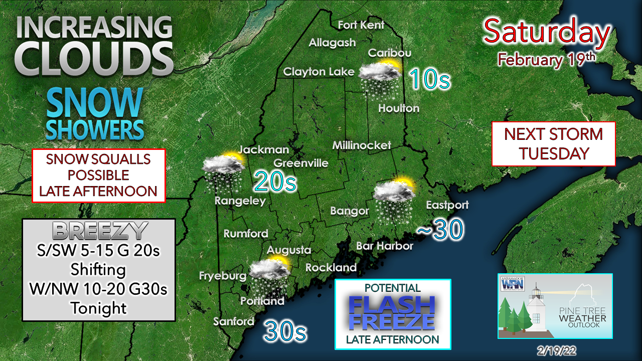
After the recent warm up, the reality of where the point of the season returns for the weekend. A spicy clipper passes through the region Saturday. The breeze returns from the south / southwest which warms the shorelines up, but most areas stay below freezing for the day. With the warm air creeping in aloft from the southwest flow, clouds increase. As the system approaches, snow showers break out. 
Picture
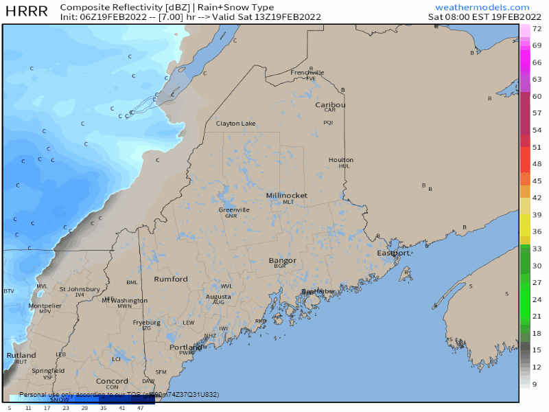
Saturday 8 AM to Sunday Midnight - Snow appears relatively light for most of the day. Squalls arrive late afternoon over western and southern areas and then move eastward through mid-evening. The squalls could produce whiteout conditions and a quick burst of accumulating snow of upwards of an inch or two. Be aware of rapidly changing conditions if you are out on the roads later in the day and evening. 

Wind increases with the passage of the front tonight, with gusts from the west / northwest at 30 - 40 mph for few hours as the system moves east. Any snow that falls may blow around and reduce visibility in spots at times until the wind settles down heading into Sunday morning. Expect wind chills below zero in the north and single digits for the coast.

Another inside runner on the way
​Tuesday into Wednesday

Picture
Monday 7 PM to Wednesday 7 PM - High pressure that keeps the region quiet through Sunday and Monday moves eastward. A southwesterly flow develops, and mild air returns starting Tuesday and continues to get warmer into Tuesday night. A storm forming over the Great Lakes Tuesday heads along the St. Lawrence River Tuesday night. Coastal areas see rain develop in the afternoon Tuesday. The mountains and foothills may deal with freezing rain at the onset which could impact evening travel. The question at this point is how far north the warm air surges as that impacts precipitation type and for how long that type falls. At this point, most of the state can expect rain out of this system with ½-1+" possible Tuesday night into Wednesday. With the parent low intensifying through Quebec, wind out of the south could bring potential for power outages along the coast. For those with shoreline interests, the 3 AM hour Wednesday high tide may bring some minor flooding and splash-over, and should be monitored for impacts there.

Snow possible late in the week

Picture
There is a signal showing potential for a snow event later in the week, but for now confidence is low being 7 days out. Guidance is hinting at a Miller B type nor'easter which could bring heavy snow for interior areas and a mixed bag for the coast, along with gusty winds. For now, it is something to watch and stay updated on as the week unfolds.

Newsflash: winter is not over. 

Picture

Temperature outlook through Thursday

The normal high and low temperature for Caribou is 25° and 6°. For Portland, 36° and 18°.  The roller coaster ride of above and below normal continues through the week. 
Picture

Be aware of snow squalls

Picture
Snow squalls are short, intense bursts of snow and wind that can catch people off guard. They can reduce visibility and cause dangerous travel conditions. If possible, avoid or delay travel until the squall passes. If you’re caught in one, slow down, turn on your headlights and hazard lights, and try to exit the road. Stay on alert, and make sure you have a way to receive alerts! 

​​Be prepared to receive alerts and stay updated

Picture
​​BE PREPARED WITH NOAA Weather Radio.
​​
​For $20-$40, it could provide vital information to you when you need it. The weather bands are standard on most public safety scanners, and newer scanner models. Weather radios can be programmed for auto alert. Click here for more information.

​► ► For the latest official forecasts, bulletins, and advisories, please check in with the National Weather Service in Gray for western and southern areas, or Caribou for northern and eastern parts of Maine.
Picture

Picture
For more information in between posts, please follow Pine Tree Weather on Facebook and Twitter. 

​Thank you for supporting this community-based weather information source which operates by reader supported financial contributions. 

Thank you as always for your support! 

- Mike

NOTE: The forecast information depicted on this platform is for general information purposes only for the public and is not designed or intended for commercial use. For those seeking pinpoint weather information for business operations should use a private sector source. For information about where to find commercial forecasters to assist your business, please message me and I will be happy to help you.

Comments
    Picture

    Mike Haggett
    Kennebunk, ME

    Certified Weather
    Forecaster
    Penn State '21

    American Meteorological Society

    National Weather Association

    Weather-Ready Nation 
    Ambassador
    ​
    ​SKYWARN-CWOP

    Matthew 19:26


    Support
    Pine Tree Weather

    DONATE

    Picture

    Picture

    Picture

    Picture

    Picture

    Picture

    Picture

    Picture

    Picture

    Picture

    Archives

    January 2023
    December 2022
    November 2022
    October 2022
    September 2022
    August 2022
    July 2022
    June 2022
    May 2022
    April 2022
    March 2022
    February 2022
    January 2022
    December 2021
    November 2021
    October 2021
    September 2021
    August 2021
    July 2021
    June 2021
    May 2021
    April 2021
    March 2021
    February 2021
    January 2021
    December 2020
    November 2020
    October 2020
    September 2020
    August 2020
    July 2020
    June 2020
    May 2020
    April 2020
    March 2020
    February 2020
    January 2020
    December 2019
    November 2019
    October 2019
    September 2019
    August 2019
    July 2019
    June 2019
    May 2019
    April 2019
    March 2019
    February 2019
    January 2019
    December 2018
    November 2018
    October 2018
    September 2018
    August 2018
    July 2018
    June 2018
    May 2018
    April 2018
    March 2018
    February 2018
    January 2018
    December 2017
    November 2017
    October 2017

    RSS Feed

Proudly powered by Weebly