
|
First, I appreciate the feedback that was mentioned by several about the new 5-day forecast outlook that I started with Sunday's post. I am fine tuning the format of it as I go along, as you will see below. I am often reminded just how large an area Maine is to cover. There is a reason why there are two National Weather Service offices and three television market areas here. Some days I wonder if I bit off more than I can handle when I went statewide back in 2016, but you folks keep sending me cash, so obviously I am doing something right at times. On the cash note, I am still down over $1,400 for the year ahead. Any help here is much appreciated. I'd like to keep this going, but that all depends on you. You can click on the link below that will steer you to the donate page for options as to how to contribute. If you can't afford a couple bucks, I politely ask that you share what I do either on Facebook or Twitter to help increase my reach, and tell your friends and co-workers. Thank you! A spin on the atmospheric merry-go-round underway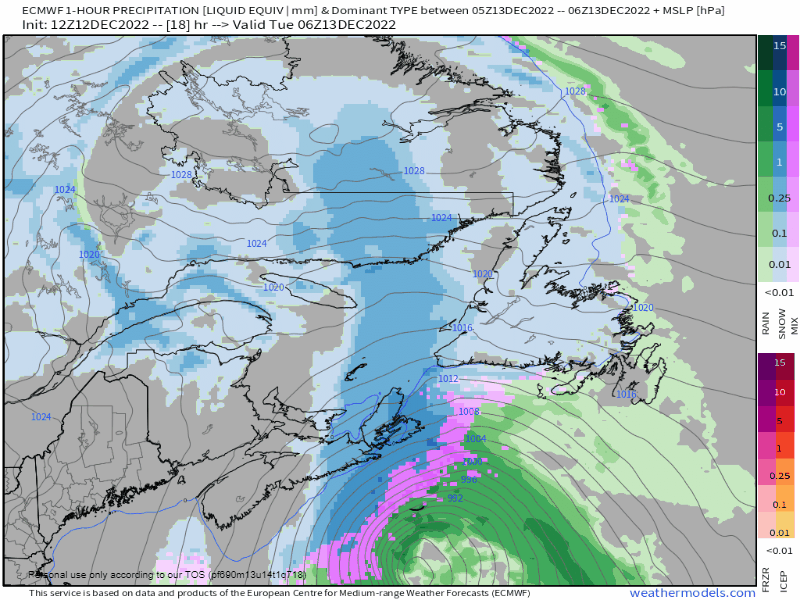 Tuesday 1 AM to Wednesday 7 PM: I am going to nerd out here and say this is just fun. It's not too often these Fujiwhara effect type scenarios spin up, let alone between 40-45° north latitude. Nova Scotia east of Halifax is going to get hammered with high wind, surf, and areas of heavy snow that will pinwheel around the upper-low. The surface low passes over Prince Edward Island and New Brunswick, then through DownEast areas on Wednesday before heading out to sea. Snow showers, potential for snow squalls and breezy conditions are the main issues for Maine through Wednesday while the Maritimes dig out. Both regions should prepare for what is next this weekend. Prepare your vehicle for winter travel Other things to add to this list: check your windshield wiper fluid and top that off. If you can't remember the last time you replaced your windshield wipers, it's time to do that. I suggest keeping your windshield wipers UP and AWAY from the windshield when parked during a storm. Reason being is the wiper motor. I can say first hand that replacing a wiper motor is expensive, and for some makes and models, there is either limited stock or no supply at all. If you break that, you're vehicle will be off the road for a while. If your car is like mine and the hood gets in the way of the wiper arms, check your owners manual to find the wiper service mode to engage that for the arms point to 12 o'clock so you can remove them from the windshield. Confidence on weekend Nor'easter increasing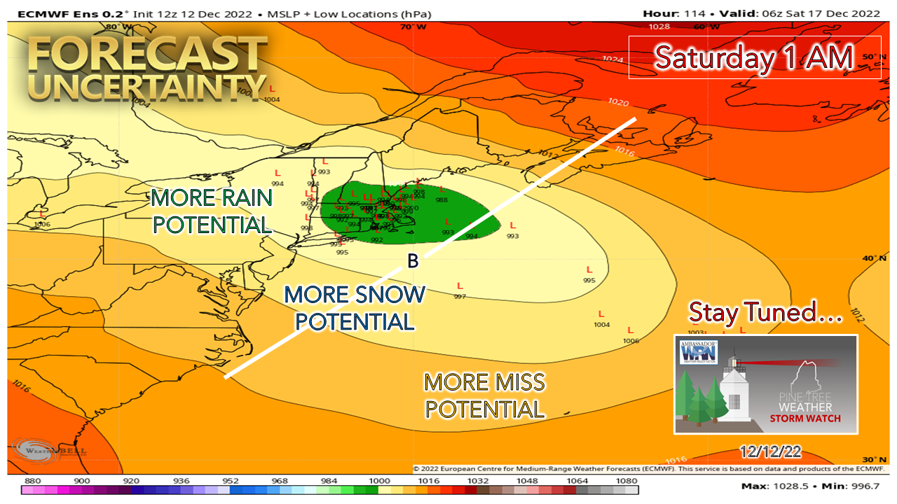 At this point, there has been a big shift west with the European ensembles, which if that idea is to hold would create a wetter outcome. At this point as of Monday afternoon, I do not believe that the models are reading the kicker energy to the north that will steer the storm, nor do I believe guidance is handling the blocking to the northeast in the aftermath of the Fujiwhara effect type set up that is playing out through Wednesday. Both factors play a huge point in how this is going to play out. As a result, I can't take the guidance output for precipitation amounts (whether snow or liquid equivalent in rain) seriously as of yet. There is quite a spread in ensemble ideas that presents questions on timing, intensity, and impacts as well. There are plenty of moving parts that still need to be figured out and there could be a shift in track as a result. The bottom line at point is there is potential for heavy wet snow, travel impacts, strong wind, and power loss. It is wise to prepare now, no matter where you live here. It is also important to note here that the wind will remain gusty in the wake of the storm through Monday. Any power outages could take time to repair and get back online. For the shorelines, if a coastal hugger track plays out, expect concerns with the high tides Saturday morning in the 4 AM hour and Saturday evening in the 5 PM hour. While we are off astronomical highs, there is concern for storm surge and surf which may cause issues along the immediate coast. Stay tuned! Five-day forecast through SaturdayTUESDAY BREEZY CONDITIONS STATEWIDE SNOW SQUALL POTENTIAL NORTH North & Mountains: Cloudy w/ chance of snow showers East: Clouds & Sun, chance of a snow shower South: Sun early, clouds increase w/ chance of an evening snow shower Wind: NW 5-15 G20-30 Lows in the teens for most Highs 20s North / 30s South Windchill 10s/20s WEDNESDAY WINDY CONDITIONS STATEWIDE SNOW SHOWERS OVERNIGHT TUESDAY INTO WEDNESDAY NORTH & EAST SLICK SPOTS POSSIBLE WEDNESDAY MORNING NORTH & EAST BLOWING SNOW POSSIBLE IN THE NORTH THROUGH THE DAY North & Mountains: Cloudy w/ chance of snow showers Northern areas may pick up 1-2" of snow, lighter amounts elsewhere by morning. Additional snow accumulation ≤ 2". East & MidCoast: Cloudy w/ chance of snow showers. Snow accumulation ≤ 2". South: Sun & clouds, chance for a snow shower Wind: N/NW 10-20 G25-35 Lows in the teens for most Highs 30s North / near 40 south Windchill 20s/30s THURSDAY BREEZY CONDITIONS STATEWIDE Statewide: Sun & clouds Mountains: Snow showers possible Wind: NE 5-15 G20-30 Lows in the 20s for most Highs 30s North & Mountains, 40s East & South Windchill 20s/30s FRIDAY - SUBJECT TO CHANGE NOREASTER WATCH HEAVY WET SNOW POTENTIAL WIND INCREASING DURING THE DAY INTO OVERNIGHT SATURDAY TRAVEL IMPACT CONCERNS POWER OUTAGE POTENTIAL South, Mountains, MidCoast: Precipitation begins early Friday, expands northeast North & East: Mainly cloudy with precipitation beginning Friday evening into the overnight Saturday Wind: E/NE 5-15 G20-30 Lows 20s North, around 30 south Highs 30s North, near 40 shorelines Windchill 10s/20s SATURDAY - SUBJECT TO CHANGE NOREASTER WATCH HEAVY WET SNOW POTENTIAL WIND CONTINUES TRAVEL IMPACT CONCERNS POWER OUTAGE POTENTIAL South: Precipitation ends in the morning, sun & clouds in the afternoon Mountains, East, North: Precipitation continues through the day, ending Saturday night. Snow showers continue in the far north and mountains into Sunday. Wind: NE 10-20 G25-35 shifting NW 10-20 G25-35 in the afternoon, continuing overnight into Sunday Lows in the 20s North, 30s Mountains & East, near 40 South Highs in the 30s North & Mountains, 40s South & East Windchill 20s/30s Current deficit for 2023 = $1,425 Thank you as always for your support! If you like what I do, please hit the like button on Twitter and Facebook, and please share! Stay updated, stay on alert, and stay safe! - Mike NOTE: The forecast information depicted on this platform is for general information purposes only for the public and is not designed or intended for commercial use. For those seeking pinpoint weather information for business operations, you should use a private sector source. For information about where to find commercial forecasters to assist your business, please message me and I will be happy to help you. |

Mike Haggett
|


