
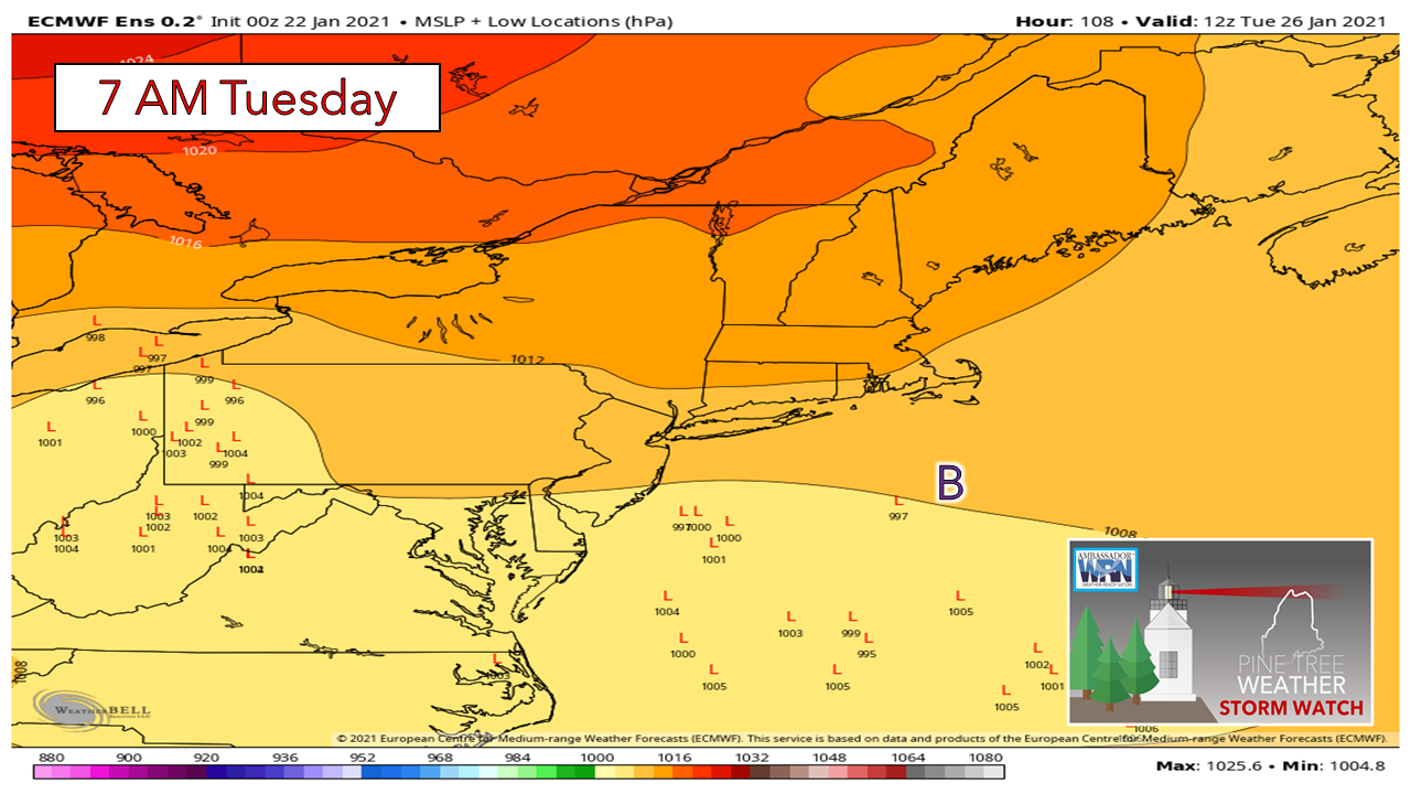
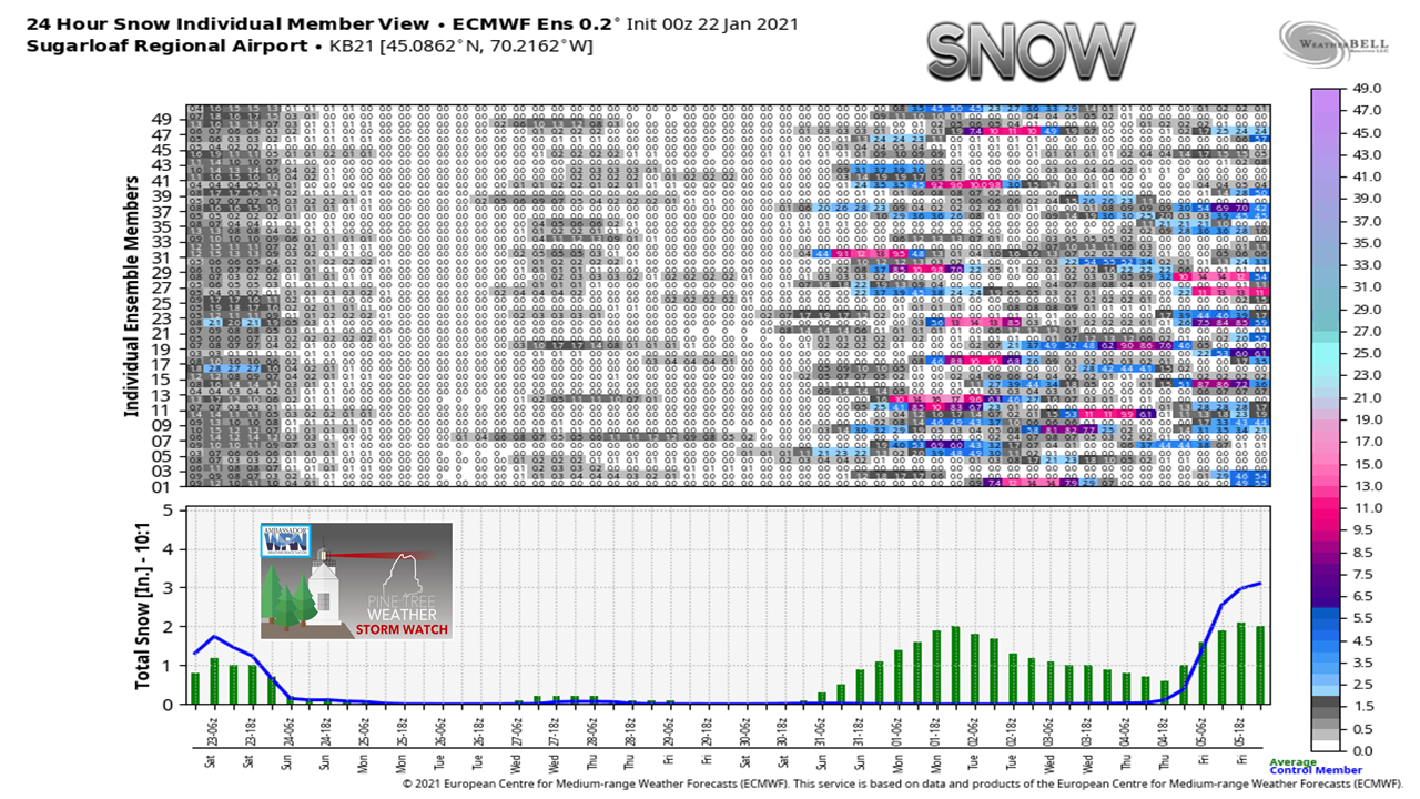
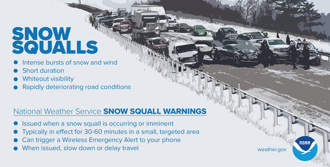
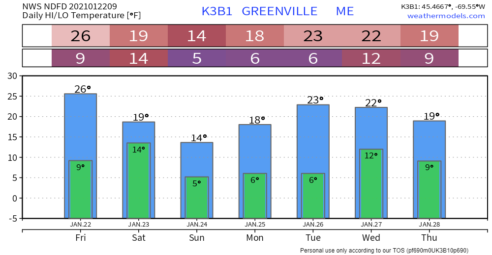
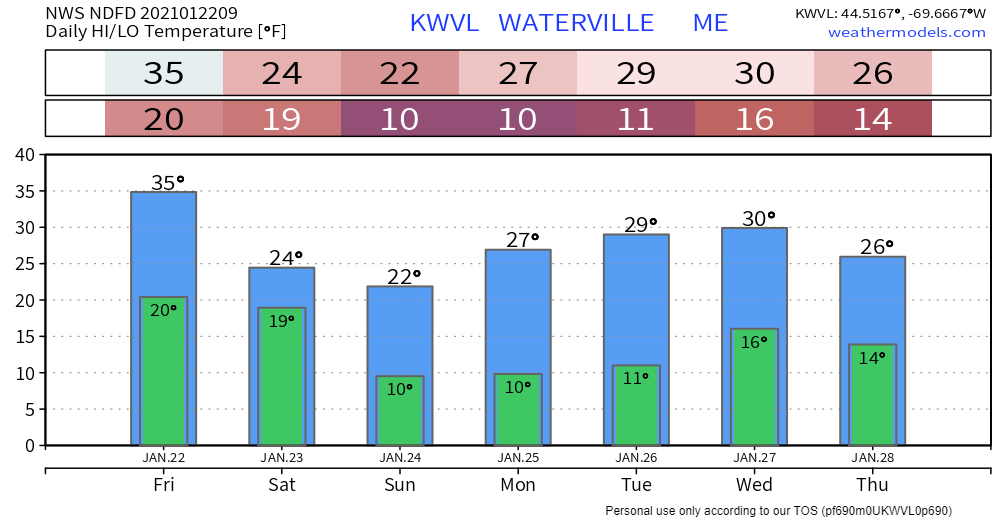
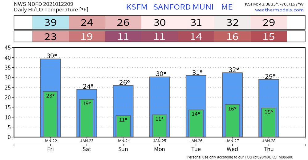
Be on alert for surprise snowA preface here: there is a lot going on in the atmosphere over the region Friday. Snow shower activity this morning is being caused by a warm front nosing in from the southwest. There will be a pause in precipitation before a cold front approaches in the afternoon. There is also an upper level trough working into the region. The axis thereof will influence snowfall amounts for Saturday. While all of this is going on, an ocean storm forms well to the southeast, but sets up an inverted trough scenario as the axis of the upper level trough passes through, which could enhance snowfall along the coast. The bottom line here is the potential for surprise snowfall with quick accumulations through Saturday. 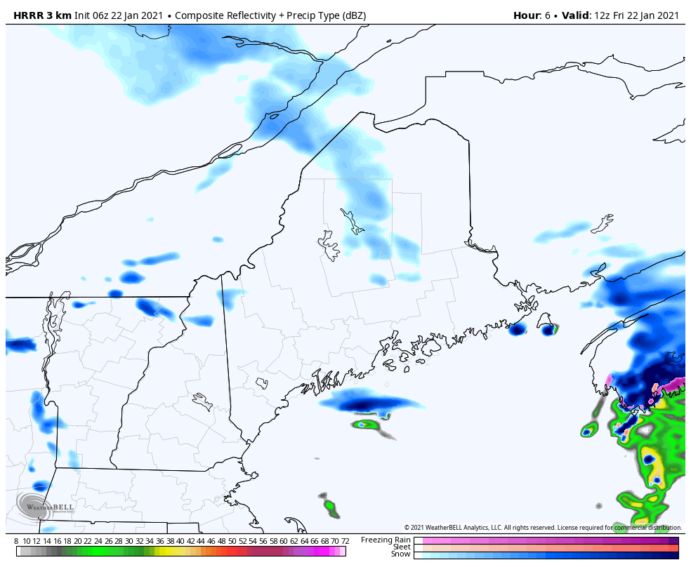 The HRRR here looks at the convective side of the situation. While the term "convection" is associated more for thunderstorms, it is also apart of winter weather, and in this case the risk of snow squalls. Cold air advection steepens the temperature lapse rates and with moisture combines to set up strong gusty winds, spurts of heavy snowfall, which leads to whiteout conditions and slick roads. The main threat for these squalls appear to be in the afternoon into mid-evening for southern areas. An inverted trough sets up and passes through the region overnight into Saturday, which could bring areas of squalls and shots of heavy snow through early afternoon. The HRRR shown here shows the potential for all of this well. Not shown with this model is the upslope snow showers for the mountains which could bring several inches of accumulation there through Saturday as well. 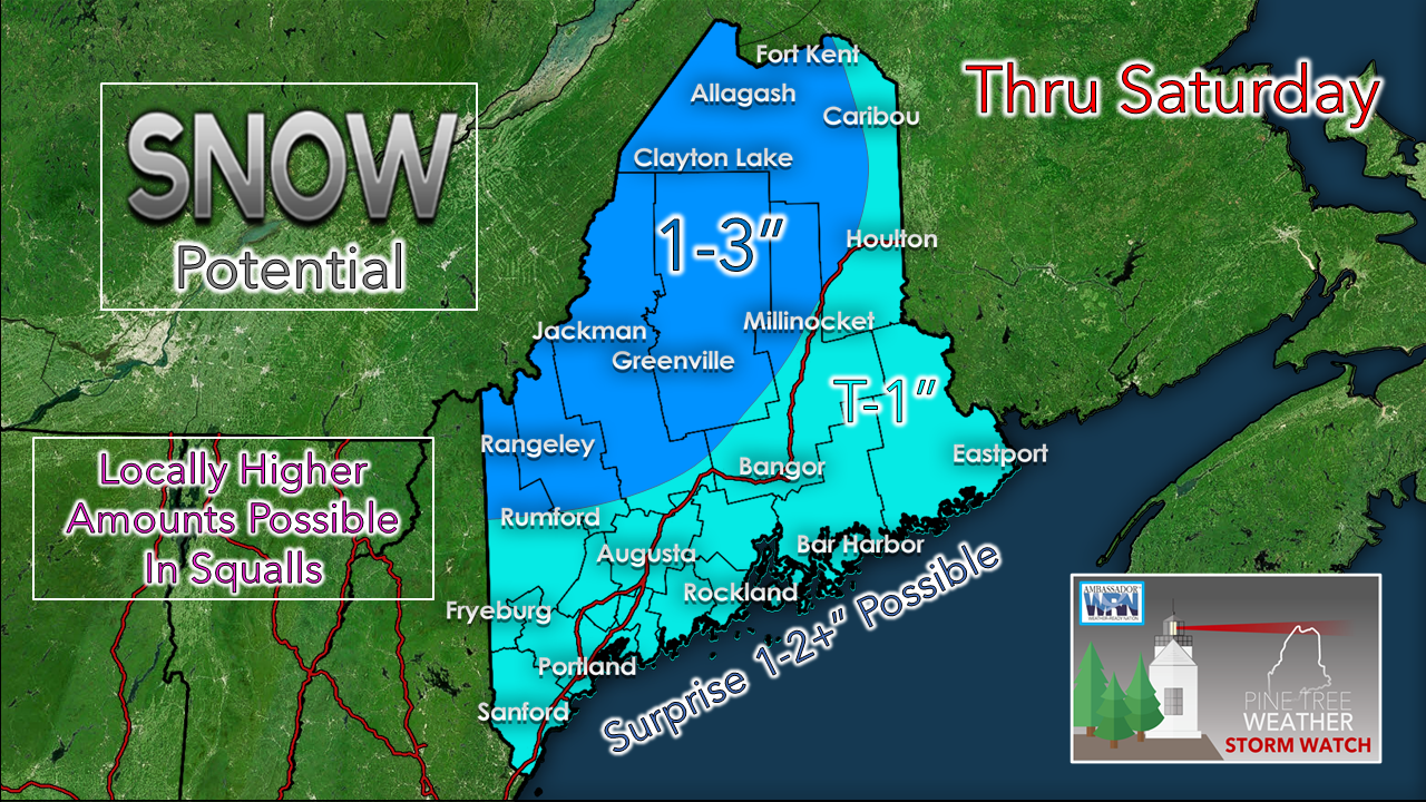 Where the squalls pass is where the accumulation comes south and east of the high country. The idea of an inverted trough has me thinking there could be a surprise couple of inches or more of snow from Portland to Eastport through Saturday afternoon. While all of this is going on, the wind comes in. It will feel like January Saturday night into Sunday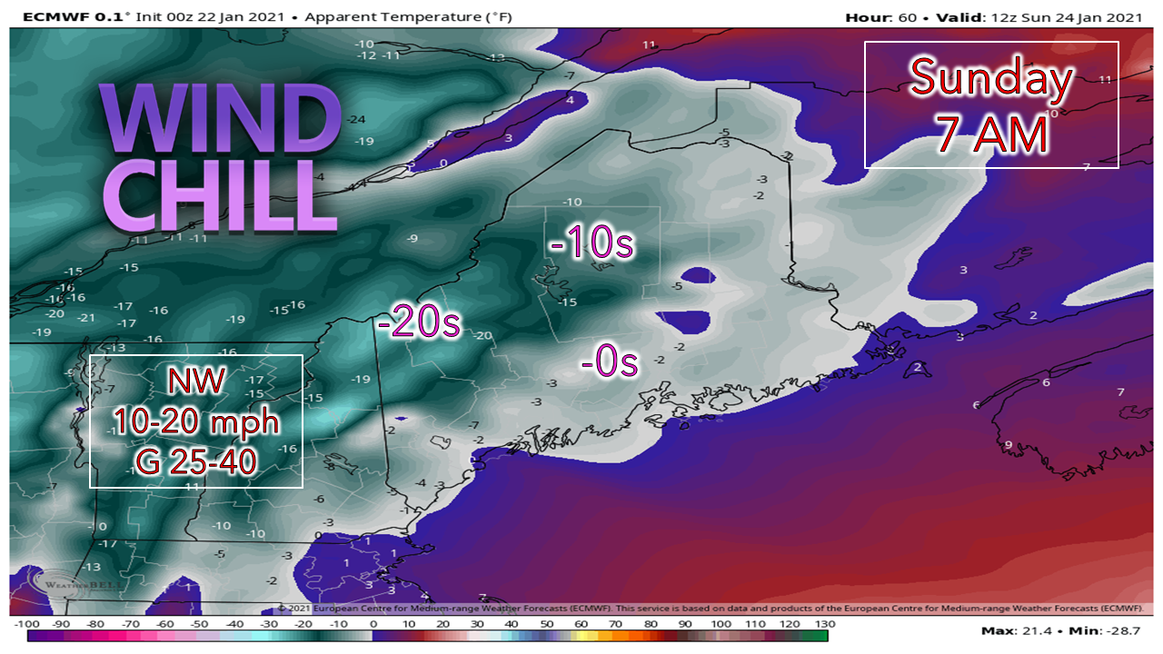 With the upper level trough and associated surface high working in behind a rapidly intensifying storm tracking to Newfoundland, arctic air pours into the region Saturday night into Sunday. Folks in the mountains could see a wind chill advisory posted. Sunday appears to be bitterly cold with the wind. As the high moves in and the storm moves well northeast, the icy breeze settles down Sunday night. Potential storm early next week |
| | BE PREPARED WITH A NOAA Weather Radio. For $20-$40, it could provide important information to you when you need it. The weather bands are standard on most public safety scanners, and newer scanner models. Weather radios can be programmed for auto alert. Click here for more information. |
| ► ► For the latest official forecasts, bulletins and advisories, please check in with the National Weather Service in Gray for western and southern areas, or Caribou for northern and eastern parts of Maine |  |
please follow Pine Tree Weather on Facebook and Twitter.
Thank you for supporting this community based weather information source operates by financial contributions.
Stay updated, stay on alert, and stay safe!
Thank you as always for your support!
- Mike

Mike Haggett
Kennebunk, ME
Weather-Ready Nation
Ambassador
Certified Weather
Forecaster
Penn State '21
American Meteorological Society
National Weather Association
SKYWARN-CWOP
Matthew 19:26
Please
Support
Pine Tree Weather
In 2024


Archives
July 2024
June 2024
May 2024
April 2024
March 2024
February 2024
January 2024
December 2023
November 2023
October 2023
September 2023
August 2023
July 2023
June 2023
May 2023
April 2023
March 2023
February 2023
January 2023
December 2022
November 2022
October 2022
September 2022
August 2022
July 2022
June 2022
May 2022
April 2022
March 2022
February 2022
January 2022
December 2021
November 2021
October 2021
September 2021
August 2021
July 2021
June 2021
May 2021
April 2021
March 2021
February 2021
January 2021
December 2020
November 2020
October 2020
September 2020
August 2020
July 2020
June 2020
May 2020
April 2020
March 2020
February 2020
January 2020
December 2019
November 2019
October 2019
September 2019
August 2019
July 2019
June 2019
May 2019
April 2019
March 2019
February 2019
January 2019
December 2018
November 2018
October 2018
September 2018
August 2018
July 2018
June 2018
May 2018
April 2018
March 2018
February 2018
January 2018
December 2017
November 2017
October 2017