|
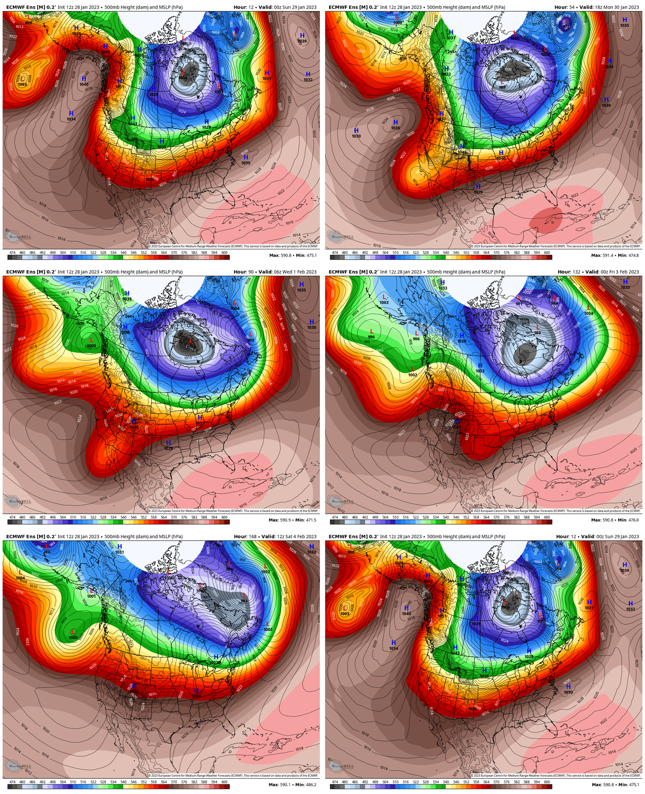
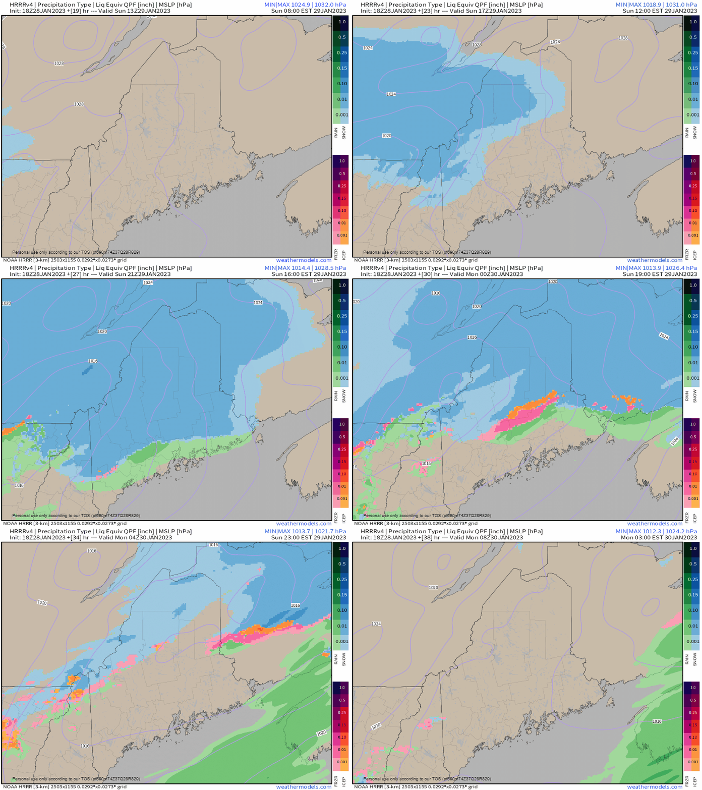
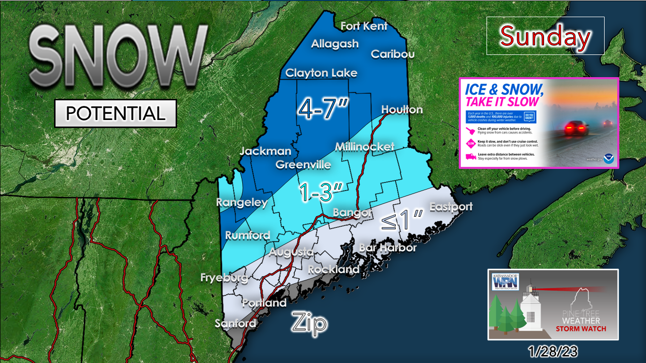
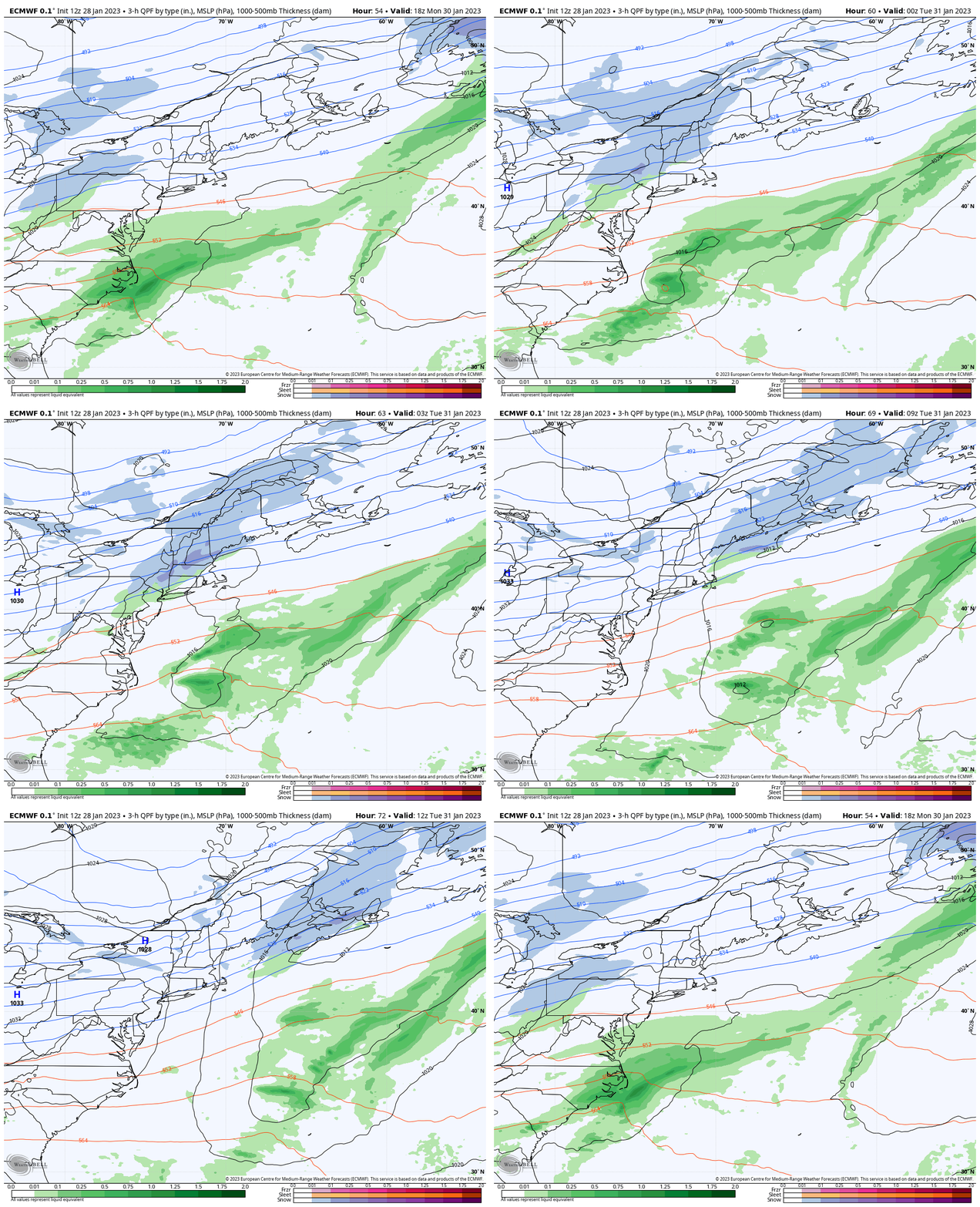
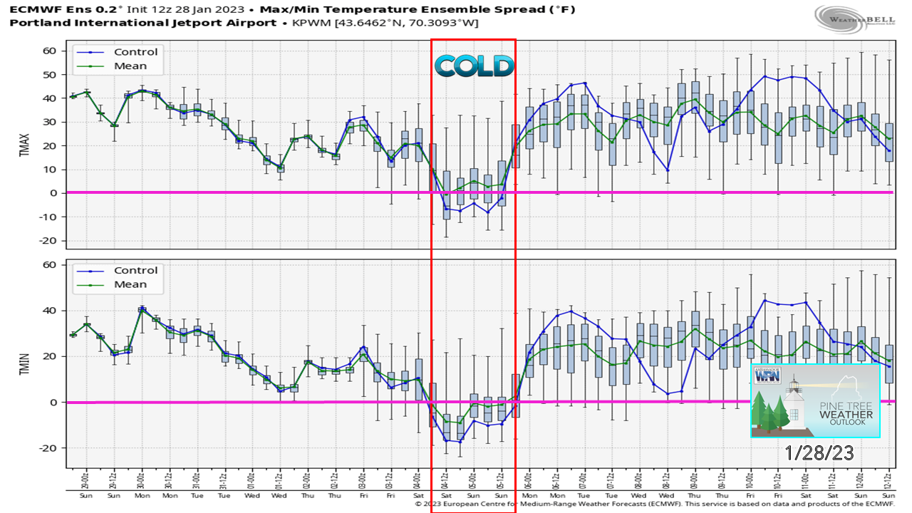
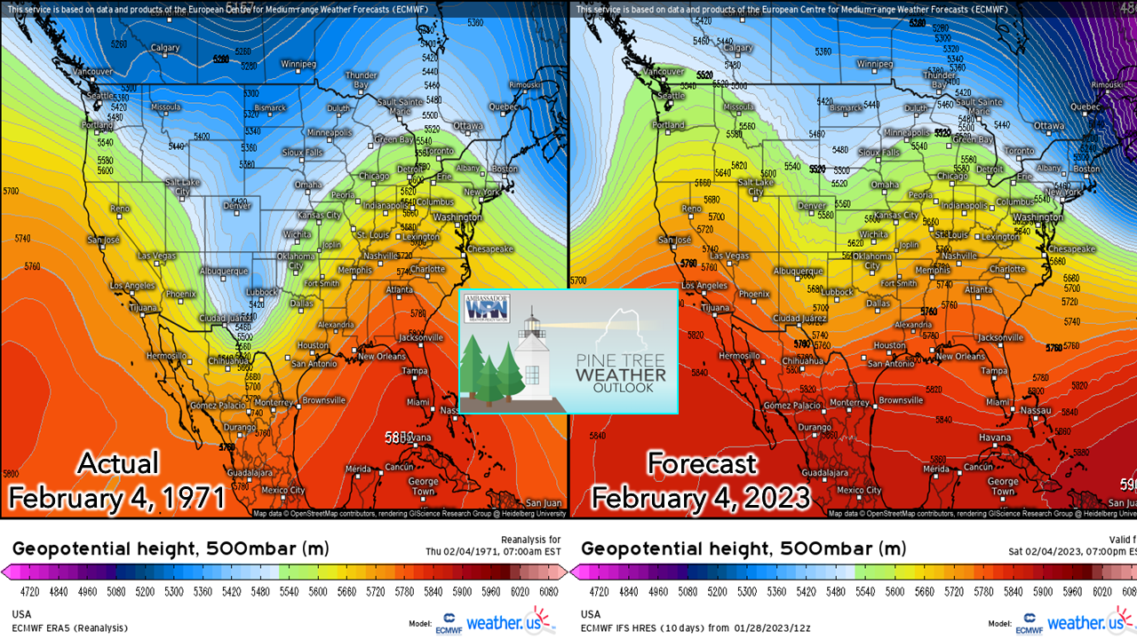
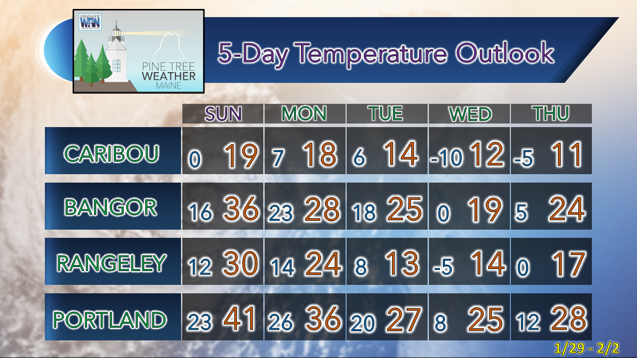
Pardon me for taking a break on Friday. A touch of illness and a whole lot of being worn out from the recent stretch of weather got to me and I needed to take care of myself. Given the number of balls I am juggling with life, I need to step back at times in order to stay sharp and deliver my best effort here. My focus through the winter here is on storms and impact weather. The day-to-day forecasting of chasing cloud cover and mountain snow showers is not my thing as a single man operation. Seeing the teams of people on television and in the National Weather Service offices, I am amazed that I pull it off as well as I do. In some cases, I don't do so well, but usually I am not alone in that regard. The atmosphere is a lot bigger than me, but the journey of the past 11 years of doing this has been incredible, and I thank you for giving me an opportunity to serve you. Watching the cold minion to the northSaturday 7 PM to next Sunday 7 PM - The cold to the north has been bottled up over Hudson Bay for several days now. It's been blocked all around from going too far given all the ridging around the Northern Hemisphere. This is the "polar vortex" which is an accurate meteorological term that unfortunately some media outlets have hijacked and used as a scare tactic for headlines and clickbait internet stories. Given the strong ridging containing it, it does appear to uncork a bit over the northeast United States and Eastern Canada, but this isn't a stratospheric warming event that will unload the cold to create a Hoth like experience for days on end, but it doesn't appear to go too far southeast for too long. I'll get into the late week cold later in the post. Overall, a relatively boring upper-level pattern is in store once we get through a couple waves, the first on Sunday, and then the next one Monday night, and then a deeper trough comes in late week. A bit of everything on the way for SundaySunday 8 AM to Monday 3 AM - A weak area of low pressure passes to the northwest in a classic inside runner track, but with the cold air in place from Saturday night's cold frontal passage, the temperatures stay cold enough for snow. Another cold front moves in to sweep the precipitation out of the region Sunday evening. Ahead of it, a gusty southwest wind flow develops and brings rain showers to the coastal plain, a bit of a mix over the foothills, and snow for the mountains and north. For most areas, this is a nuisance event. It will be enough to scrape and salt for the western foothills up into southern Aroostook. The ski hills and the north will pick up some good fluff out of this. The Liquid equivalent with this will push one-third of an inch where snow is expected to accumulate the most. The taller peaks of the ski hills and Katahdin may pick up 8-10" out of it with the serious fluff factor being the key contributor as higher ratio snow event. Statewide snow Monday night into Tuesday morningMonday 1 PM to Tuesday 10 AM - An upper-level trough dips down from the northwest and picks up some juice from the Great Lakes and brings some snow to the area. I think the evening commute on Monday should be mainly snow free in the usual 3-6 PM window over the south. Third shifters are likely to be driving into it during the overnight. Another nuisance event here as a general 1-3" is expected out of this one across the state, with all areas seeing accumulations to deal with to start Tuesday morning. Expect some slick spots to start off, but improvement on the roads should occur as the morning progresses. About the cold late weekEveryone knows it is February, right? Sometimes I am puzzled by people's reactions when you tell them it is going to get cold. It's supposed to be cold this time of year. The state has been spoiled with well above normal temperatures all winter. I am looking at the ensemble range of high and low temperatures for Portland on Saturday when it is expected to be the coldest. No question it could be the coldest night of the season thus far. It's about three weeks late getting here. As you can see, it's a one hit wonder. We'll have one day of cold and by Monday morning it will be long forgotten. If you have cold sensitive water pipes, you'll want to make sure they stay warm, but this isn't going to last long. Another point to note on this chart is the range of temperatures indicated by the gray boxes and the whiskers that go above and below each. A bit of a climatology lesson here... Going through the history of February 4th through all the data that I could dig up where I could present some idea of the pattern brought me to 1971. Outside of the deep trough to the west that was going on, the area east of the Mississippi is pretty much in line with the ridge. The actual ridge of 1971 was a bit further east than what is being predicted here. For those that have followed me for a while know that I go on an occasional rant in winter because models tend to move deep cold too progressively. As cold as the air is over Hudson Bay it is like throwing a cinder block. Cold air is dense, often times it does not cooperate with model ideas (see also: cold air damming events). While I can see where this could be the coldest day of the season thus far (that is easy, we haven't had that many) I don't think it will be as cold as the European model (or others on the cold side) predict. If I have done my homework correctly, the last time Portland recorded a complete 24-hour period below zero is January 15, 1957. The only other time in recorded history that occurred was before that on February 15, 1943. The chances of Portland staying below zero for the entire day is highly unlikely. Also, the ocean temperature is in the 40s, and that plays a big factor in this as well. Climatologically speaking, it doesn't make sense what the models are putting out right now. So, what did the final almanac data look like for February 4, 1971? Caribou: Low -30° / High +4° Bangor: Low -26° / High +15° Portland Low: -19° / High +13° Of the three, Caribou has a legit chance of staying below zero on Saturday. We'll have one day of bitter temperatures. Make sure your pipes are ready to handle it. Temperature outlook through ThursdayWe are near the tail end of what is typically the coldest time of the year. The average high and low for Caribou for January 28 is 20° and 1°. For Portland, 32° and 15°. The cool down is on the way late week. Thank you as always for your support! You may not like the weather, but I hope you like what I do! Please hit the like button on Twitter and Facebook, and share! Financial donations to fund what I do are always appreciated! Stay updated, stay on alert, and stay safe! - Mike NOTE: The forecast information depicted on this platform is for general information purposes only for the public and is not designed or intended for commercial use. For those seeking pinpoint weather information for business operations, you should use a private sector source. For information about where to find commercial forecasters to assist your business, please message me and I will be happy to help you. |
Mike Haggett
|

