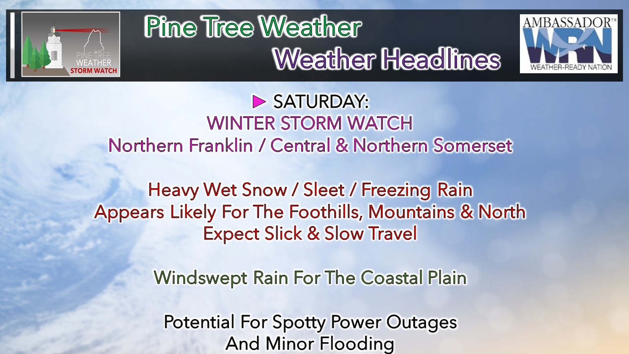
 The tropical river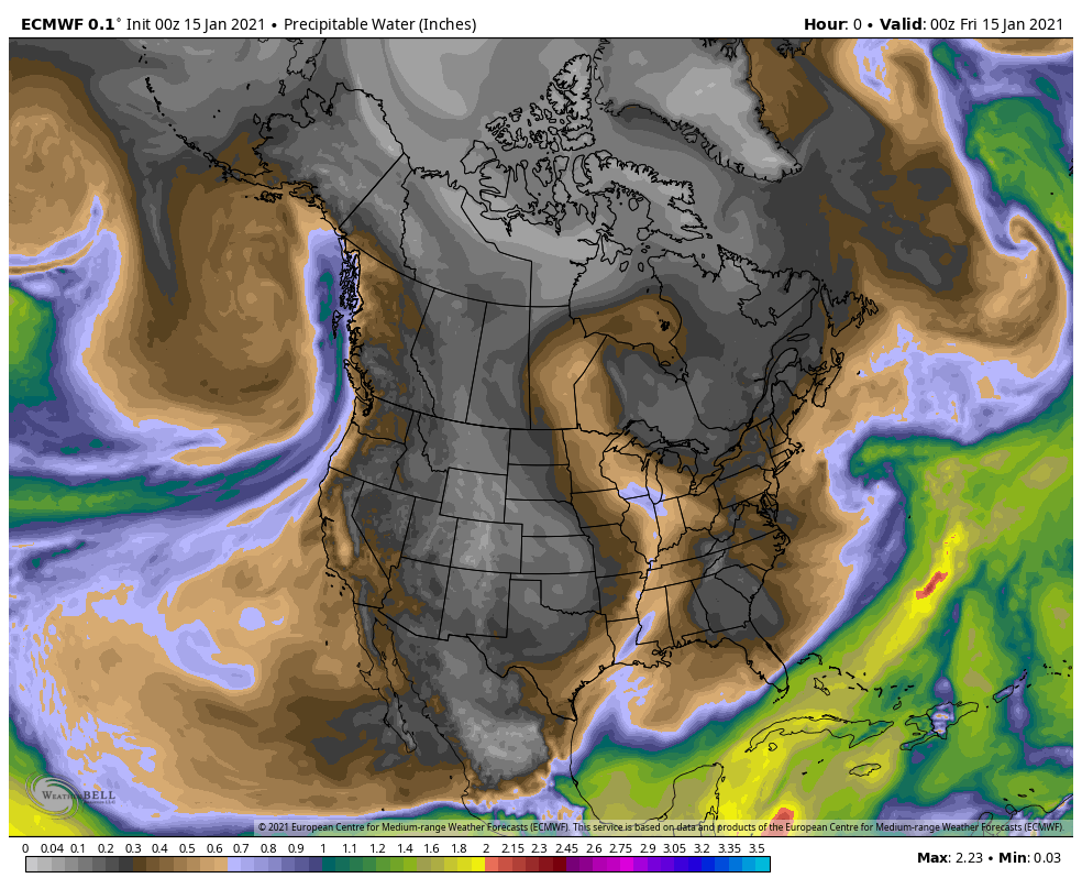 There is a fascination to watching precipitable water flows on water vapor imagery and forecast loops like this one. One can easily depict the storm that generates and blows up over the north Atlantic from the weak front that passed through the region Thursday. The blizzard going on over the upper Midwest taps into the moisture in the Gulf of Mexico and brings a sloppy wet kiss to the region on Saturday. This is well above normal moisture for mid-January. If it were colder, we'd get buried with this one. The mountains and north appear to do well with this one, but for the coastal plain, what little snow that is left could be all but gone by Sunday morning. Timing and precipitation amounts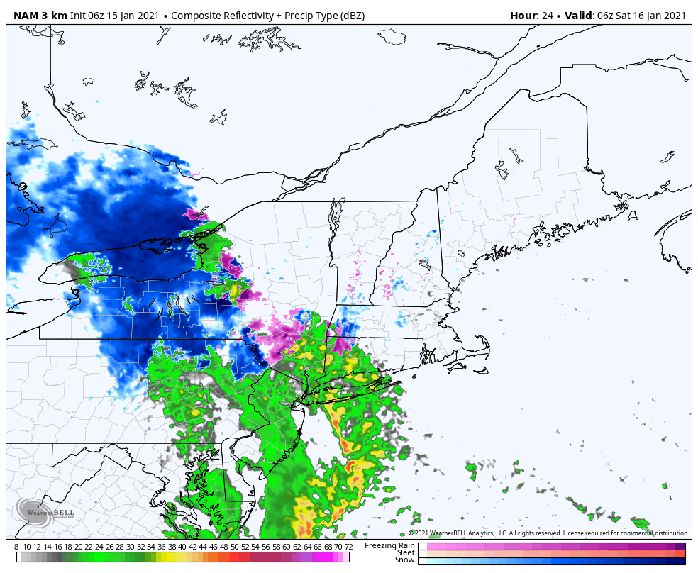 This loop of the NAM radar idea runs from 1 AM to 7 PM Saturday. For eastern and northern areas, you'll get mainly dry morning. For western and southern areas, the moisture will have to fight through some dry air at first, but the tropical influence takes over. Expect the snow / mix / rain to take over for most areas by noon, and expand north and east through the afternoon. 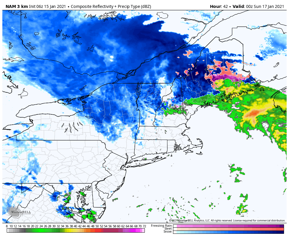 This loop from 7 PM Saturday to 1 PM Sunday indicates it could be all but over precipitation wise for southern areas by early evening. Far northern areas get in on the action Saturday night. Precipitation ends over eastern areas by around midnight, and for northern and mountain areas, it appears to be around daybreak Sunday for the steadier amounts. Notice that as the storm passes the wind shifts to the west. Upstate New York appears to get a really good lake effect event on the backside of this, and that funnels over into Vermont, New Hampshire and the mountains of Maine Sunday. 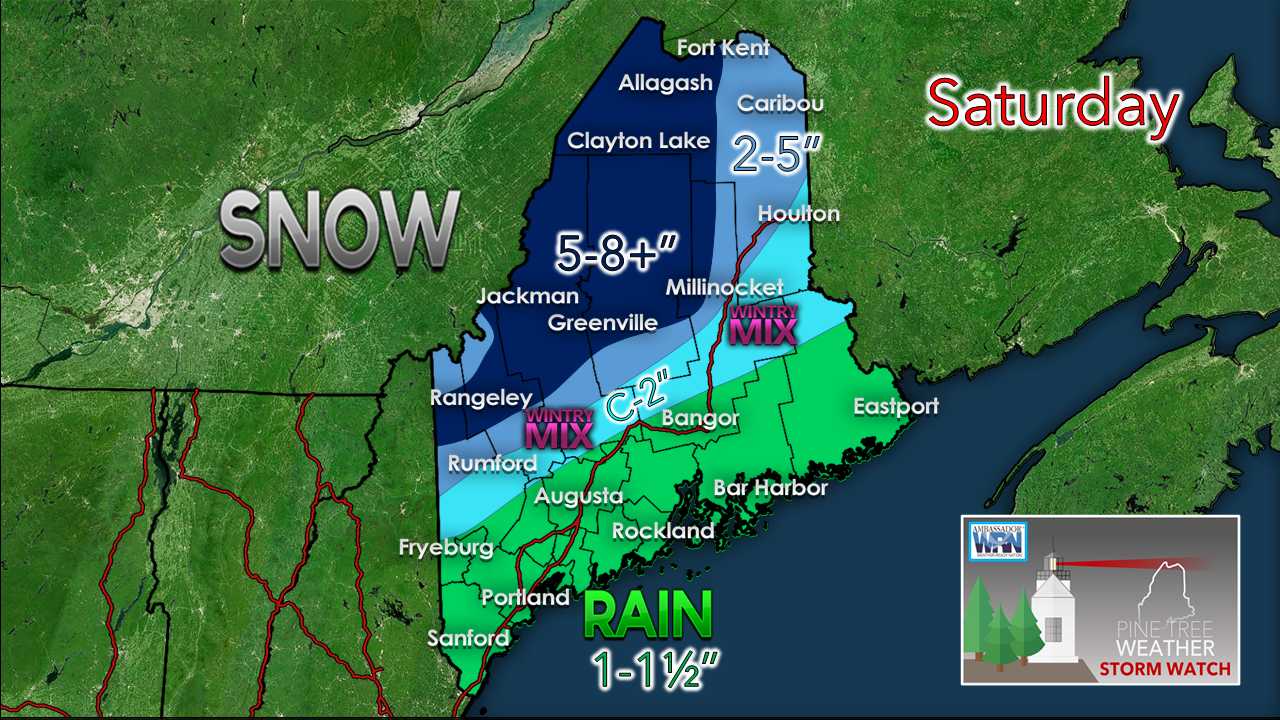 I will be right up front and say the higher peaks could get a foot or more of snow from this. Elevation does play a role in who gets how much, but folks above the 1500 foot level should have snow to move with this one. A note for those in the western foothills on over into southern Aroostook, expect sleet and freezing rain to mix in, along with rain. A note for all... the trend continues to get slightly cooler with every model run. This increases snow and cuts down on the mixing, and could shift frozen precipitation amounts a bit closer for southwestern areas. Towns like Fryeburg / Brownfield / Porter / Parsonfield... I am talking about you. There is potential for surprise there. Banding could ultimately play a role in this as it almost always does, which means some towns could bust low or high. Any subtle shifts with track which could bring a deviation of temperature within a degree or two could effect precipitation outcome. A lot of hairsplitting going on in the atmosphere, and in my mind. You people wonder why I am bald. I did it for you. For areas south of the mountains, there is still the chance for some minor flooding with this from snow melt and run-off. In areas of heavy rain, reduced visibility from downpours, areas of fog and ponding on roadways could lead to hydroplane potential on the speedier roads. The wind factor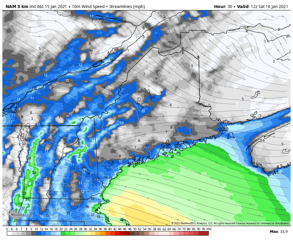 The wind picks up Saturday morning, bringing peak gusts to areas west of Penobscot Bay by around noon, and for DownEast areas late in the afternoon. The strongest wind gusts end from west to east late Saturday afternoon for the MidCoast & southwestern areas, and by around midnight for eastern areas. 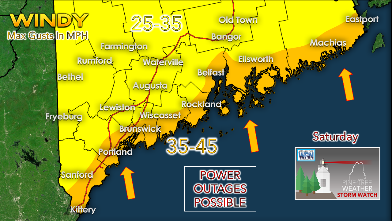 Spotty power outages are the concern for the shorelines. Folks who get heavy wet snow over the interior could see outages there also. This storm isn't as amped as some we have seen in the fall and to this point in winter. The National Weather Service has been toying with the idea of a wind advisory, so don't be surprised to get notified about one. Your weather reports are appreciated! mPINGers Wanted! Report your weather anywhere anytime anonymously and help improve forecast verification. No special training required. Download the mPING app and start reporting what you see from any location. For more information, check out the mPing site. Be prepared to receive alerts and stay updated!
For more information in between posts,
please follow Pine Tree Weather on Facebook and Twitter. Thank you for supporting this community based weather information source operates by financial contributions. Stay updated, stay on alert, and stay safe! - Mike |

Mike Haggett
|