
Rain, heavy at times through Tuesday morning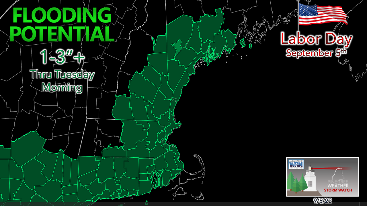 For folks heading south, it would be wise to get on the road as soon as possible. For folks flying today, please check with your airline for potential cancellations. A flood watch has been posted from Maine to Alabama. The longstanding adage in the weather forecasting world is that droughts don't end well. While southwestern Maine is on the fringe of the rain, I suspect the overall impacts to be localized, but the areas that do get in on the training of backfilling torrential rain may get a bit more than they bargained for. For those travelling, expect a slow ride. Potential for hydroplaning, urban street flooding, reduced visibility from heavy rain and areas of fog are likely. It could be bumper-to-bumper traffic from Wells south as visitors and summer residents head home. For those that don't need to travel today other than locally, it's a good day to stay home. Maine on the cooler northern flank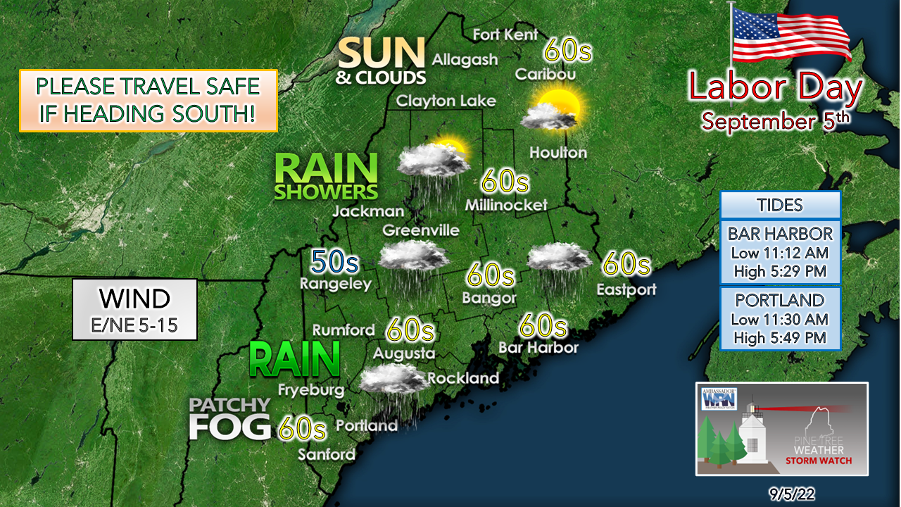 The frontal boundary that passed through the region Sunday and Sunday night has parked itself over southern New England. Northern areas above Moosehead and Baxter enjoy a dry and seasonably cool day with some sun at times. The further south, the more of a washout it turns into. Timing of the rainfall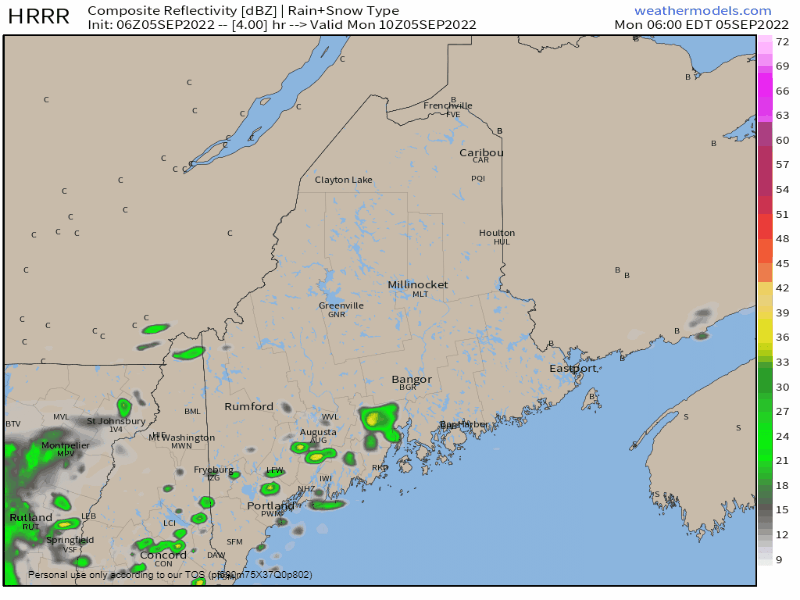 Monday 6 AM to 8 PM - To emphasize and to explain the training of rainfall, I use this 15-minute interval loop of the HRRR model issued at 2 AM Monday. As disturbances ride along the stalled frontal boundary, a north / northeast wind throws cold air into warm and with the moisture pump on high from the Gulf of Mexico, that combination sets up potential for training, and this loop shows that idea well. It's these localized soakers that will dump the most rain and set up flooding potential along with travel impacts. 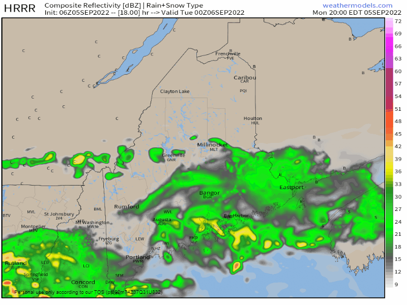 Monday 8 PM to Tuesday 8 AM - Back to 1-hour increments here shows rain continuing through the overnight and will likely impact the Tuesday morning commute as it continues. Pockets of rain could be heavy at times. Early birds hitting the roads can expect and assortment of travel hazards from the rain, ponding on roadways, and areas of fog. If you happen to come across a flooded roadway, turn around and opt for a safer route.  Tuesday 8 AM to 8 PM - Rain beings to taper off as the frontal boundary sinks to the south. Conditions gradually improve as the drying out process begins in the afternoon. Expect areas of fog around over southwestern areas Tuesday night into Wednesday morning. Potential rainfall amounts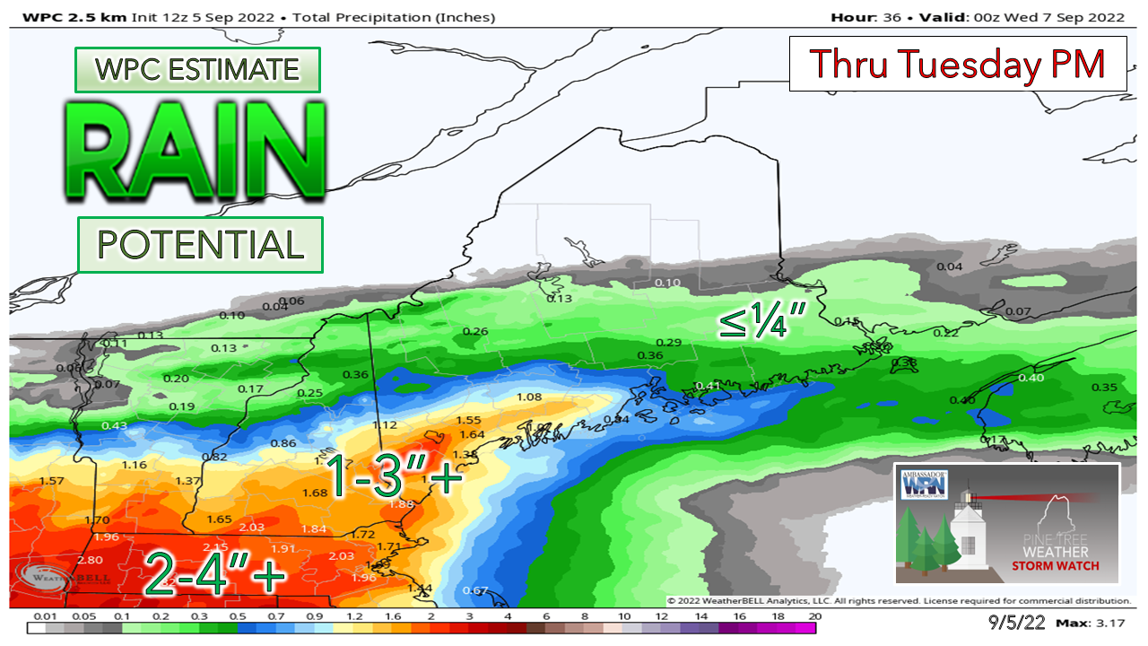 The 1-3" rainfall potential region is what has initiated the flood watch region. I am not finding a reputable model source that disputes that potential, but again, Maine is on the northern fringe of this. Where there is bust potential is further north. If the front dips south, it could be a light shower or two and that maybe it. If the front nudges north, amounts increase. While it is out of my forecast area, I did find this post from the National Weather Service New York interesting (hat tip to meteorologist Frank Nocera of NWS Boston for digging this out). It discussed the historic flash flooding on Long Island, NY from August 12-13, 2014. There are very similar characteristics to the atmospheric dynamics going on here. Portland received 6.43" of rain from that system on August 13th. Is there a chance for that kind of over performance here? I can't rule it out, but unlikely. Concord, NH received 2.12" of rain from that same storm to put a potential range in context. I do expect areas of Connecticut and Rhode Island to get hammered with this. We'll see what happens. Outlook through late week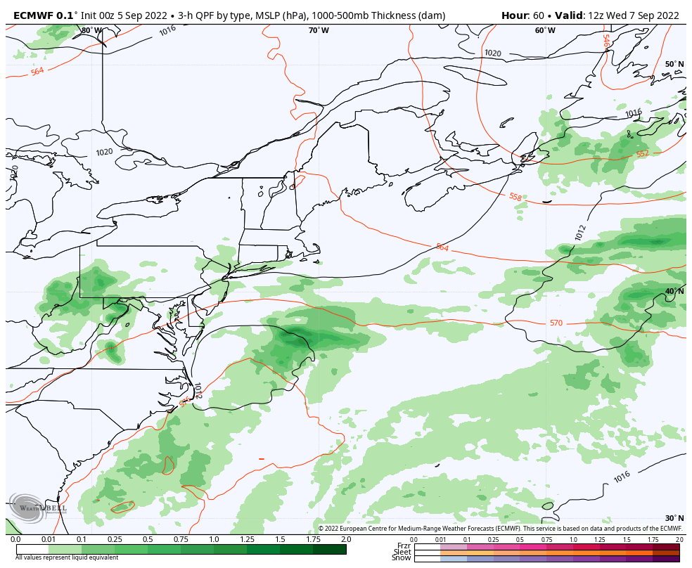 Wednesday 8 AM to Friday 8 PM - Southwestern areas will be able to dry out over the remainder of the week. A weak cold front may bring showers to the north on Thursday. Tropical storm Earl is predicted to become a major hurricane as it passes east of Bermuda on Friday. Overall, a warm and dry trend is expected into next weekend. 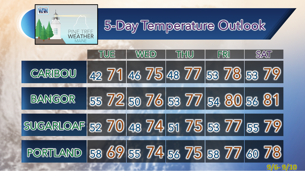 Thank you for supporting this community-based weather information source which operates by financial contributions from people like you. NEXT UPDATE: TUESDAY Stay updated, stay on alert, and stay safe! - Mike NOTE: The forecast information depicted on this platform is for general information purposes only for the public and is not designed or intended for commercial use. For those seeking pinpoint weather information for business operations, you should use a private sector source. For information about where to find commercial forecasters to assist your business, please message me and I will be happy to help you. |

Mike Haggett
|


