Pine Tree Weather
  • DISCUSSIONS
  • DONATE
  • WEATHER WALL
  • MAPS
  • RAIN OUTLOOK
  • SEVERE
  • MARINE
  • CPC OUTLOOK
  • Kennebunk
  • MY BIO
  • PTW IN MEDIA
  • OBSERVING WEATHER
  • INTERNSHIPS
  • INTERN ALUMNI
  • DISCUSSIONS
  • DONATE
  • WEATHER WALL
  • MAPS
  • RAIN OUTLOOK
  • SEVERE
  • MARINE
  • CPC OUTLOOK
  • Kennebunk
  • MY BIO
  • PTW IN MEDIA
  • OBSERVING WEATHER
  • INTERNSHIPS
  • INTERN ALUMNI

Steamy conditions over the next several days for Maine

8/4/2022

Comments


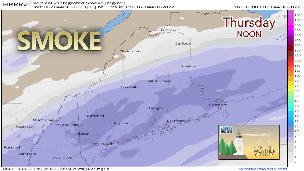
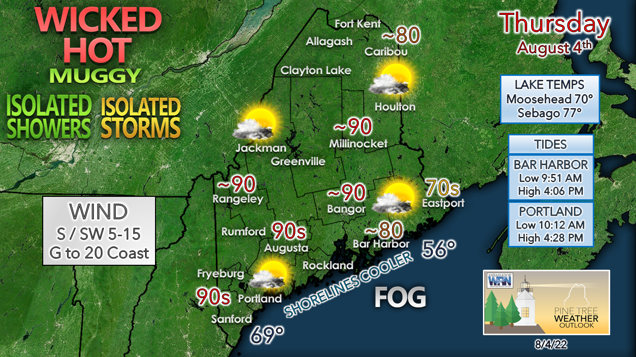
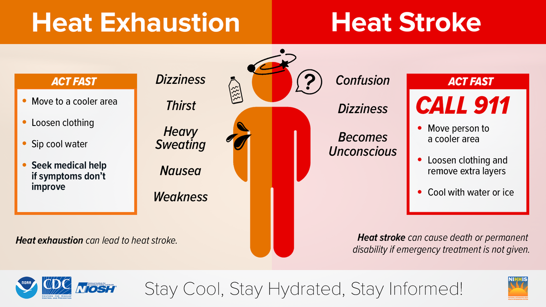
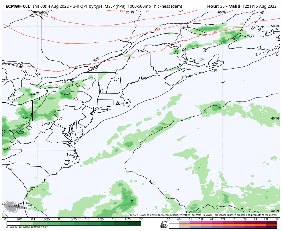
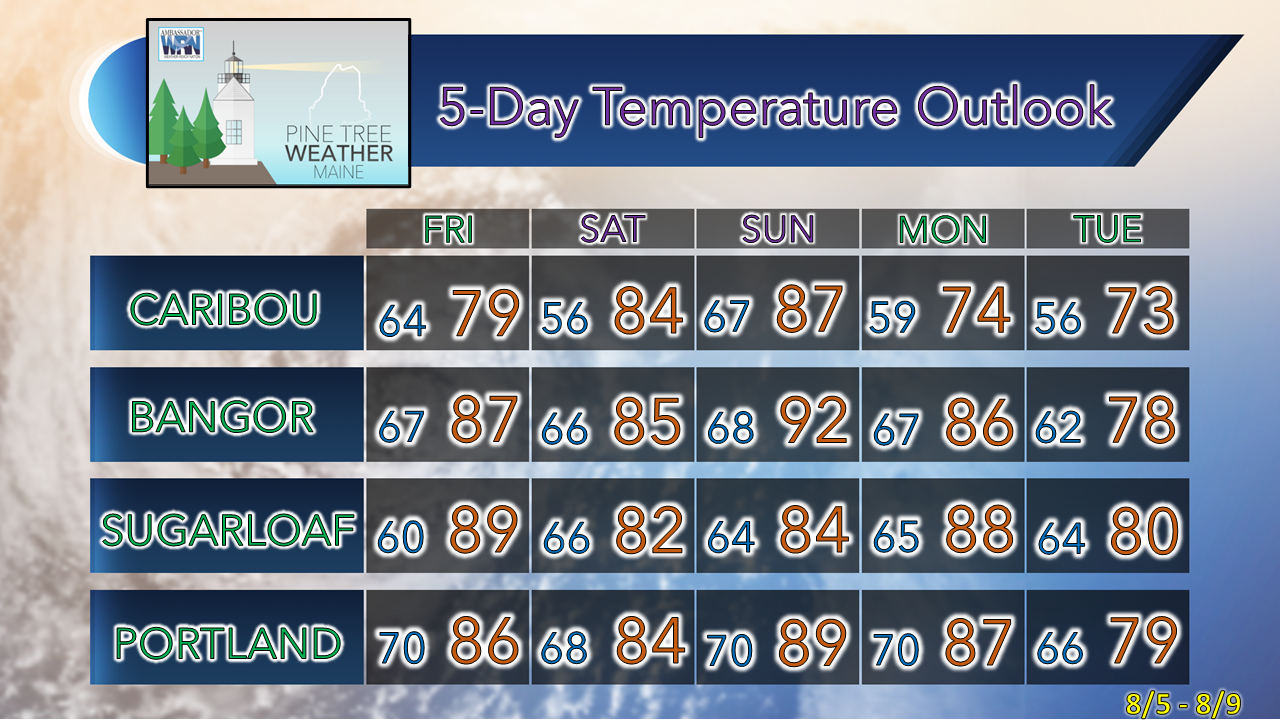
The dog days of summer

Picture
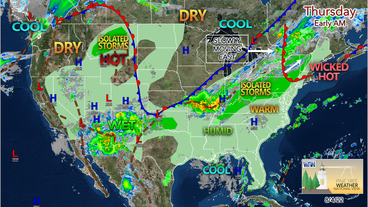
I think back to when I was kid in the late 70s. I grew up in Yarmouth on the outskirts of town. August would hit along with the heat. Box fans helped circulate the air around the house but it wouldn't cut the heat any. My mother made sun tea and lemonade, fired up the record player and loaded Neil Diamond's live two album set "Hot August Nights" and let 'em spin. I'd play in the yard, get the sprinkler going in order to find some relief with Neil singing in the background through the open windows. Those were the dog days of summer, and that pattern at home was expected when the heat of August arrived.

As of August 1st, we start heading into cooler times as that day is the peak of average high temperatures across the region. While the next few days may feel like an eternity for those without air conditioning, there are signs of a cool down later next week. When that arrives, it will feel like heaven. 

A sizzler with a touch of smoke,
​along with a shower / storm chance

Picture
Thursday 8 AM to Friday Midnight - As heat and humidity moves northeastward, it raises a slight risk of a pop-up shower or thunderstorm. As an indicator of low-level temperature lapse rates, the expected high on the summit of Mount Washington is expected to be in the mid-60s while nearby Fryeburg and Berlin, NH are likely to hit the 90-95° range. A capping inversion of dry air aloft quells a widespread storm threat. With air moving and thus lifting over the higher elevations, interior areas where the cap may be agitated enough to initiate some convection through Thursday evening. With the amount of moisture around, torrential rainfall is likely in any storms, along with gusty winds. The severe risk is very low, but cannot be ruled out given the tropical air mass in place. 
Picture
To add haze to the sky, smoke from the wildfires out west dims the sun through the day and moves offshore Thursday night. It could be a great evening to catch a neat sunset. Grab an ice cream and have your cameras ready, especially along the coast! 
Picture
Areas of fog over interior areas are expected to dissipate by mid-morning. Looking at early morning satellite observations while factoring in the increase of dew points has me thinking that the fog may hang on over or stay close to the shorelines and islands for MidCoast and DownEast areas, which that would keep those areas cool while interior areas roast.

If you are headed to the beaches, keep in mind space gets cramped by mid-afternoon as the tide comes in. A sea breeze takes the edge off the shoreline areas in the afternoon, but with the humidity it may not bring much relief other than moving the air around. 

Heat indices may reach blast furnace levels of 95-100° for Fryeburg, Sanford, Lewiston-Auburn, Augusta, Bangor and Millinocket as dew points rise into the mid 60s to around 70°. 

Stay hydrated, stay cool and exercise early! 

Picture

Outlook through the weekend and beyond

Picture
Friday 8 AM to Sunday 8 PM - An old summer friend, the Bermuda High, appears to flex its muscle over the near future. A slow-moving cold front approaching from the northwest stalls out over the region over the weekend as the High slams the door on any forward progression. This brings hope for the severe drought areas along the coast as it increases potluck shower and storm activity Friday afternoon. Folks heading to the seaside communities and beaches should be aware that is a possibility. 

Waves try to chip away at the blocking high through Sunday and may not have much luck as the cyclone enhances its grip, continues to pump heat and humidity in and fizzles out any widespread shower and storm impacts, keeping those threats isolated, but certainly a possibility to keep in mind and stay on alert for. 
Picture
Thursday 8 AM to next Thursday 8 PM - This graphic of precipitable water values shows the Bermuda high spinning steamy conditions into the region that brings in periodic gross to disgusting levels of humidity through the first half of next week. A strong cold front with an associated upper-level trough says enough is enough and is expected to drive the sauna out to sea Wednesday into Thursday.  Hopefully the region gets a decent charge of rain when it does, but time will tell. 

As the Bermuda High contracts, the region gets a bit of a break from the heat on Tuesday, but expect one more surge of high humidity Wednesday before dry air works in Thursday. 
Picture

Thank you for supporting this community-based weather information source which operates by financial contributions from people like you. 
​
Stay updated, stay on alert, and stay safe!

NEXT UPDATE: FRIDAY

- Mike

​NOTE: The forecast information depicted on this platform is for general information purposes only for the public and is not designed or intended for commercial use. For those seeking pinpoint weather information for business operations, you should use a private sector source. For information about where to find commercial forecasters to assist your business, please message me and I will be happy to help you.

Comments
    Picture

    Mike Haggett
    Kennebunk, ME

    Weather-Ready Nation
    Ambassador

    Certified Weather
    Forecaster
    Penn State '21

    American Meteorological Society

    National Weather Association
    ​
    ​SKYWARN-CWOP

    Matthew 19:26


    DONATE

    Picture
    Picture
    Picture
    Picture
    Picture

    Picture

    Picture

    Picture

    Picture

    Picture

    Picture

    Picture

    Picture

    Picture

    Picture

    Picture

    Picture


    Archives

    April 2025
    March 2025
    February 2025
    January 2025
    December 2024
    November 2024
    October 2024
    September 2024
    August 2024
    July 2024
    June 2024
    May 2024
    April 2024
    March 2024
    February 2024
    January 2024
    December 2023
    November 2023
    October 2023
    September 2023
    August 2023
    July 2023
    June 2023
    May 2023
    April 2023
    March 2023
    February 2023
    January 2023
    December 2022
    November 2022
    October 2022
    September 2022
    August 2022
    July 2022
    June 2022
    May 2022
    April 2022
    March 2022
    February 2022
    January 2022
    December 2021
    November 2021
    October 2021
    September 2021
    August 2021
    July 2021
    June 2021
    May 2021
    April 2021
    March 2021
    February 2021
    January 2021
    December 2020
    November 2020
    October 2020
    September 2020
    August 2020
    July 2020
    June 2020
    May 2020
    April 2020
    March 2020
    February 2020
    January 2020
    December 2019
    November 2019
    October 2019
    September 2019
    August 2019
    July 2019
    June 2019
    May 2019
    April 2019
    March 2019
    February 2019
    January 2019
    December 2018
    November 2018
    October 2018
    September 2018
    August 2018
    July 2018
    June 2018
    May 2018
    April 2018
    March 2018
    February 2018
    January 2018
    December 2017
    November 2017
    October 2017

Proudly powered by Weebly