Pine Tree Weather
  • DISCUSSIONS
  • MAPS
  • BRIEFINGS
  • SATRAD
  • MARINE
  • RAIN OUTLOOK
  • SNOW / ICE OUTLOOK
  • CPC OUTLOOK
  • Kennebunk
  • Weather Geekdom
  • Who We Are
  • DONATE
  • My Photography
  • DISCUSSIONS
  • MAPS
  • BRIEFINGS
  • SATRAD
  • MARINE
  • RAIN OUTLOOK
  • SNOW / ICE OUTLOOK
  • CPC OUTLOOK
  • Kennebunk
  • Weather Geekdom
  • Who We Are
  • DONATE
  • My Photography

Storm to bring a wintry mix to parts of Maine

11/10/2019

Comments


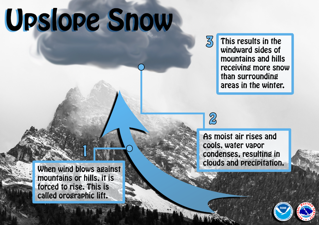
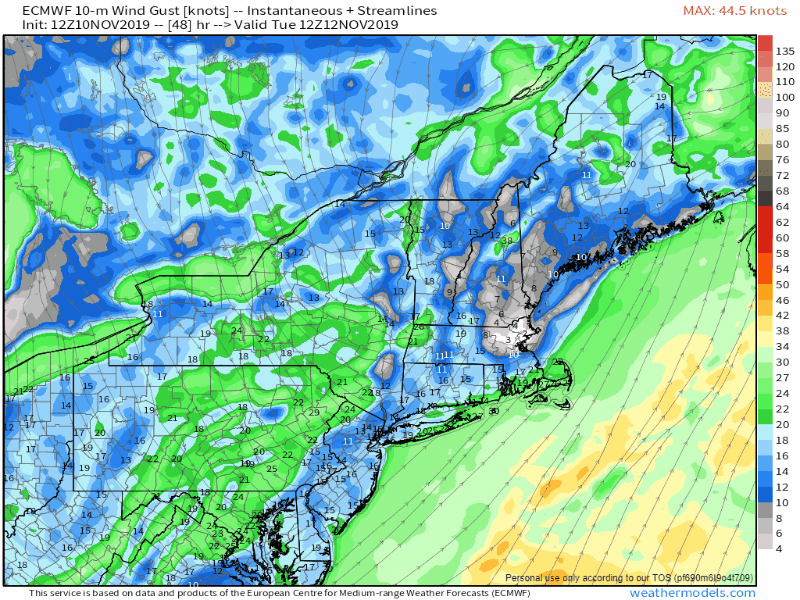
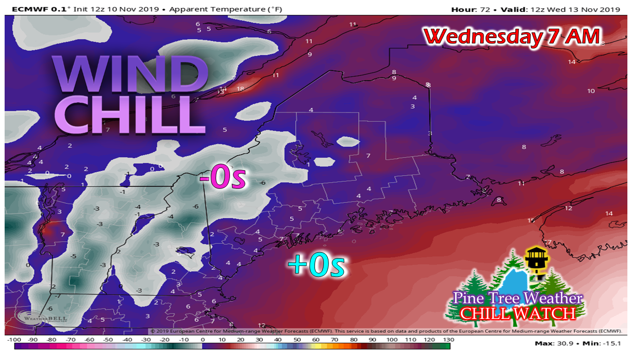
Ski country gets a kickstart

Picture
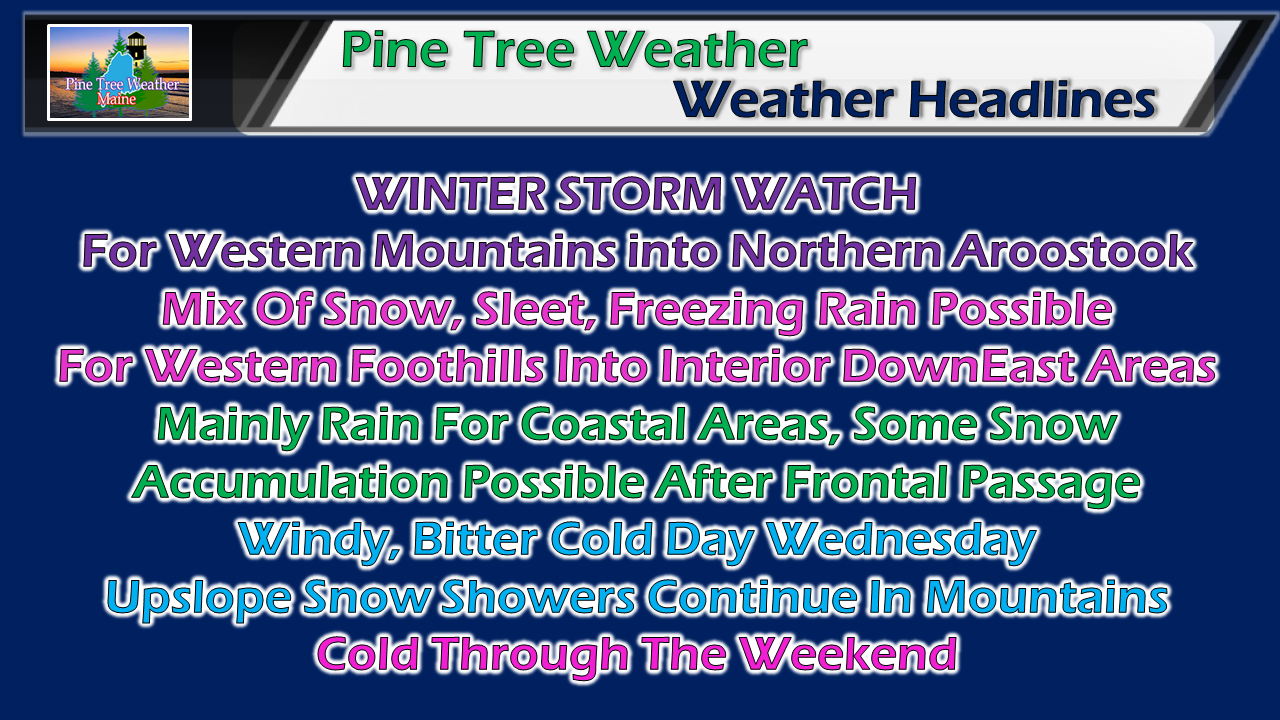
Confidence is increasing for a solid snow event for the western mountains on up into Northern Aroostook. Guidance has warmed up somewhat for coastal and interior areas around the western foothills on over to interior DownEast areas. These forecasts are always tricky and present bust potential. It all depends on the position of the frontal boundary, low pressure along that front, and how much warm air pushes over the interior will dictate how this plays out.

The four precipitation type food groups

Picture
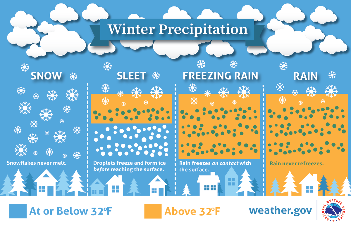
Like many early season wintry events, this one appears to feature the "warm air nose". Everything starts frozen in the upper atmosphere. What form it appears depends on where the warm air is as precipitation falls toward the surface. 

My concern remains that cold air damming may throw a wrench into all of this before all is said and done. The history of forecast guidance versus cold air at the surface is a well documented failure. For those away from the shorelines, be aware of this 

Monday and Tuesday event for most areas

Picture
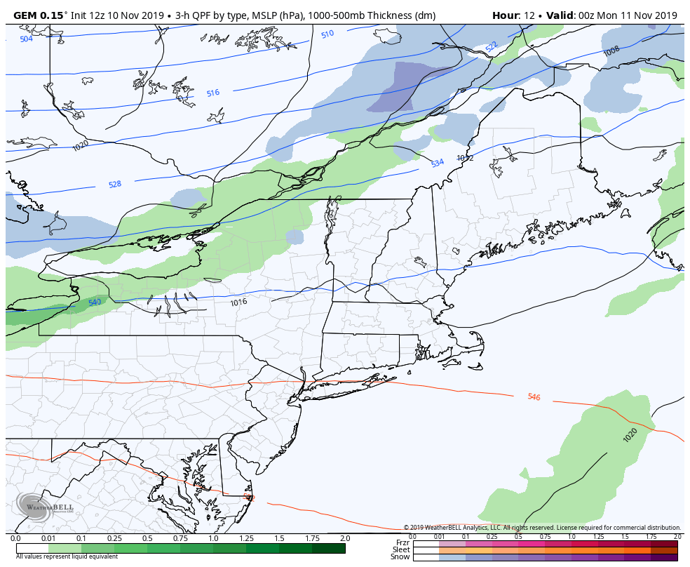
A cold front passes through the region Sunday night, then stalls to the southeast Monday morning. Moisture rides up along the front from the southwest. Low pressure forms along the frontal boundary, and brings areas of snow, a light mix, and/or rain pending on location, which becomes more widespread Monday night and continues into Tuesday. Precipitation ends for most areas from west to east Tuesday evening. Snow showers continue for the north country into Wednesday.
Picture
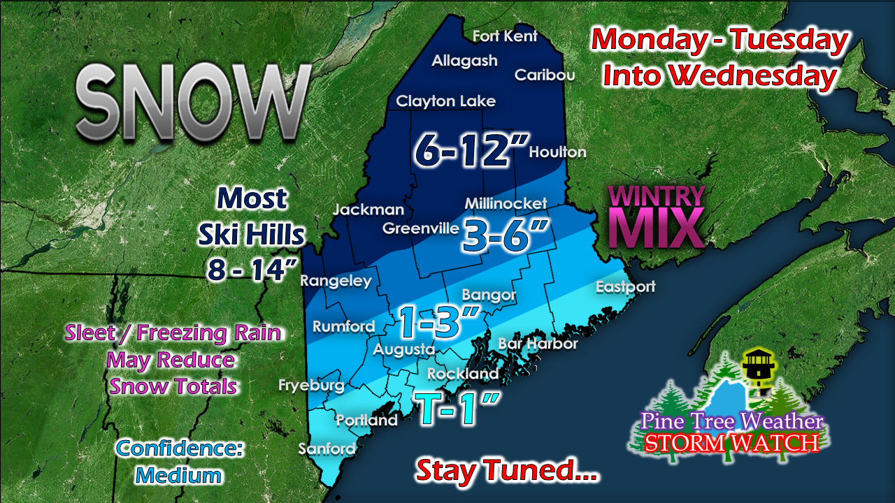
There are still time for changes with this, but I feel good about this idea as of Sunday evening. I will make adjustments if necessary as the event evolves. 

I do not expect icing to be a big issue for this one for now, outside of the hazard of slick spots on bare surfaces. Unless there is a drastic change to the forecast, I don't suspect power outages will be a concern from ice related issues, although the wind may cause a few spotty outages. 

Expect slow travel Monday afternoon through Tuesday evening. Coastal areas should be on alert that roads could get icy as rain changes to snow. 

The mountain snow machine continues into Wednesday;
bitter cold wind chill for all

Picture
After the front passes, west-northwest wind will increase and bring a January chill to the region Wednesday. Coupled with some strong upper level energy, this sets up the potential for upslope snows which will add to the totals for Monday and Tuesday. This is why I think the elevated ski hills have the potential to reach the 8-14" level by the time this is over. 
Picture
The wind begins to pick up Tuesday afternoon as low pressure heads into the Canadian Maritimes. Tuesday night into Wednesday will be breezy with gusts 15-30 mph possible (40+ higher elevations) and that will drag down bitter cold arctic air from the north. The wind begins to settle Wednesday afternoon as high pressure settles in. 

With the fresh snow pack, expect overnight low temperatures to be in the single digits and teens for Thursday morning. Temperatures will remain well below normal into next weekend. 
Picture
It will be a bitter start with the breeze Wednesday morning. Expect wind chill values in the single digits and teens at best everywhere during the day. 

Stay updated! 

Picture
► ► For the latest official forecasts, bulletins and advisories, please check in with the National Weather Service in Gray for western and southern areas, or Caribou for northern and eastern parts of Maine.

► ► DONATION DRIVE UPDATE - $840 shortfall for the year ahead! You can help keep Pine Tree Weather going with a donation of any amount now through VENMO @PineTreeWeather, a monthly donation on Patreon or messaging me on Facebook or Twitter to send a check in the mail. Thank you for your support!

For more information from me, please check the Pine Tree Weather Facebook page as well as my Twitter feed. 

Always stay weather aware!

​- Mike
Comments
    Picture

    Mike Haggett
    Kennebunk, ME

    Penn State
    Weather Forecast Certification '21.
    AMS / NWA
    Weather-Ready Nation 
    ​SKYWARN-CWOP

    Picture

    Alex Hatfield
    Wakefield,MA


    Penn State
    Meteorology and Atmospheric Science ‘21
    PSUBAMS
    Campus Weather Service
    PSU Storm Chase Team
    PSU College of Earth &  Mineral Sciences Ambassador

    Picture

    Kaitlyn Lardeo
    ​Syracuse, NY

    SUNY Oswego
    Atmospheric Science
    Lake Effect Storm Prediction and Research Center
    Northeastern Storm Conference Contributor

    DONATE
    Picture

    Archives

    January 2021
    December 2020
    November 2020
    October 2020
    September 2020
    August 2020
    July 2020
    June 2020
    May 2020
    April 2020
    March 2020
    February 2020
    January 2020
    December 2019
    November 2019
    October 2019
    September 2019
    August 2019
    July 2019
    June 2019
    May 2019
    April 2019
    March 2019
    February 2019
    January 2019
    December 2018
    November 2018
    October 2018
    September 2018
    August 2018
    July 2018
    June 2018
    May 2018
    April 2018
    March 2018
    February 2018
    January 2018
    December 2017
    November 2017
    October 2017

    Categories

    All
    Maine Weather
    Pine Tree Weather

    RSS Feed

Proudly powered by Weebly