Pine Tree Weather
  • DISCUSSIONS
  • DONATE
  • MAPS
  • NWS BRIEFINGS
  • SATRAD
  • MARINE
  • SNOW / ICE OUTLOOK
  • RAIN OUTLOOK
  • CPC OUTLOOK
  • Kennebunk
  • OBSERVING WEATHER
  • Who We Are
  • My Photography
  • DISCUSSIONS
  • DONATE
  • MAPS
  • NWS BRIEFINGS
  • SATRAD
  • MARINE
  • SNOW / ICE OUTLOOK
  • RAIN OUTLOOK
  • CPC OUTLOOK
  • Kennebunk
  • OBSERVING WEATHER
  • Who We Are
  • My Photography

Strong NorEaster to bring heavy snow, wind and rain to Maine

12/5/2020

Comments

 
Picture
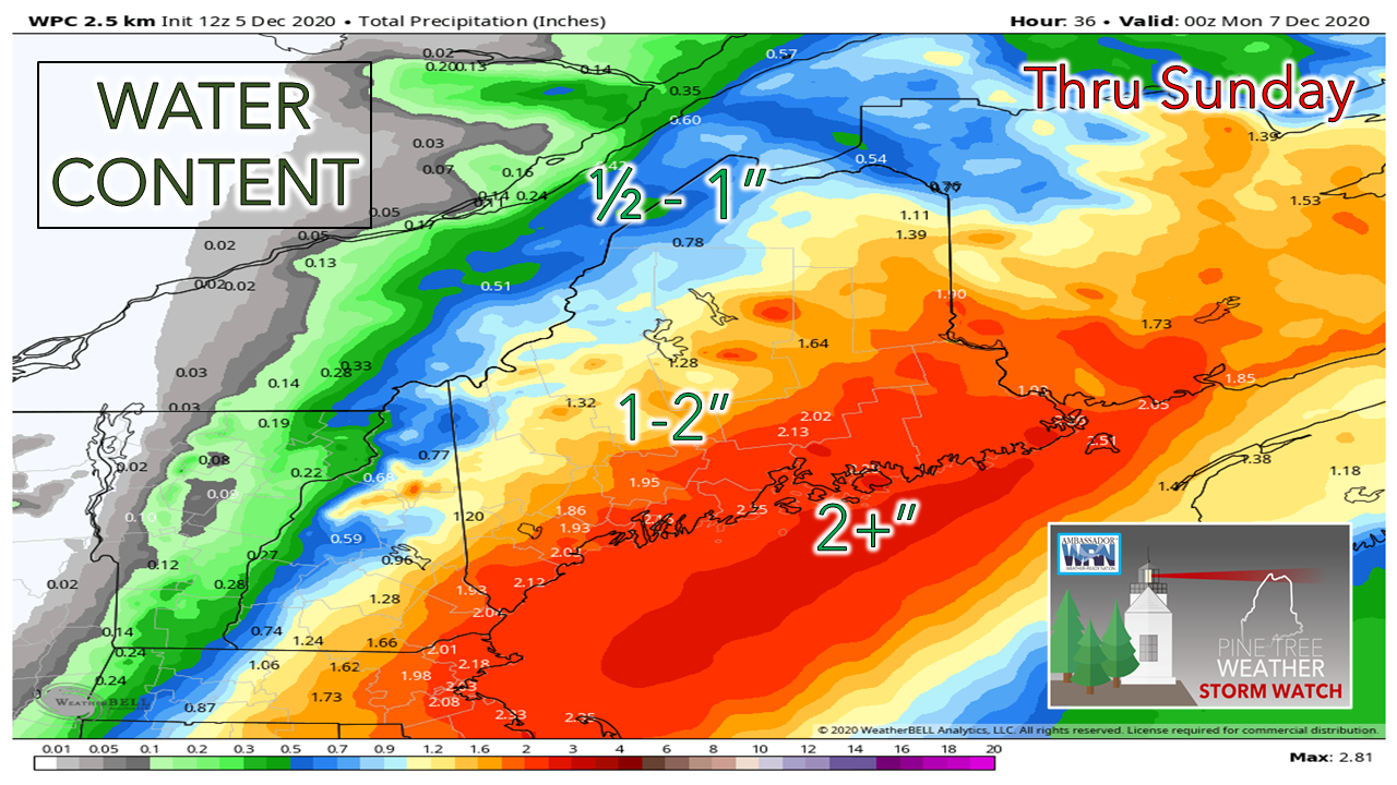
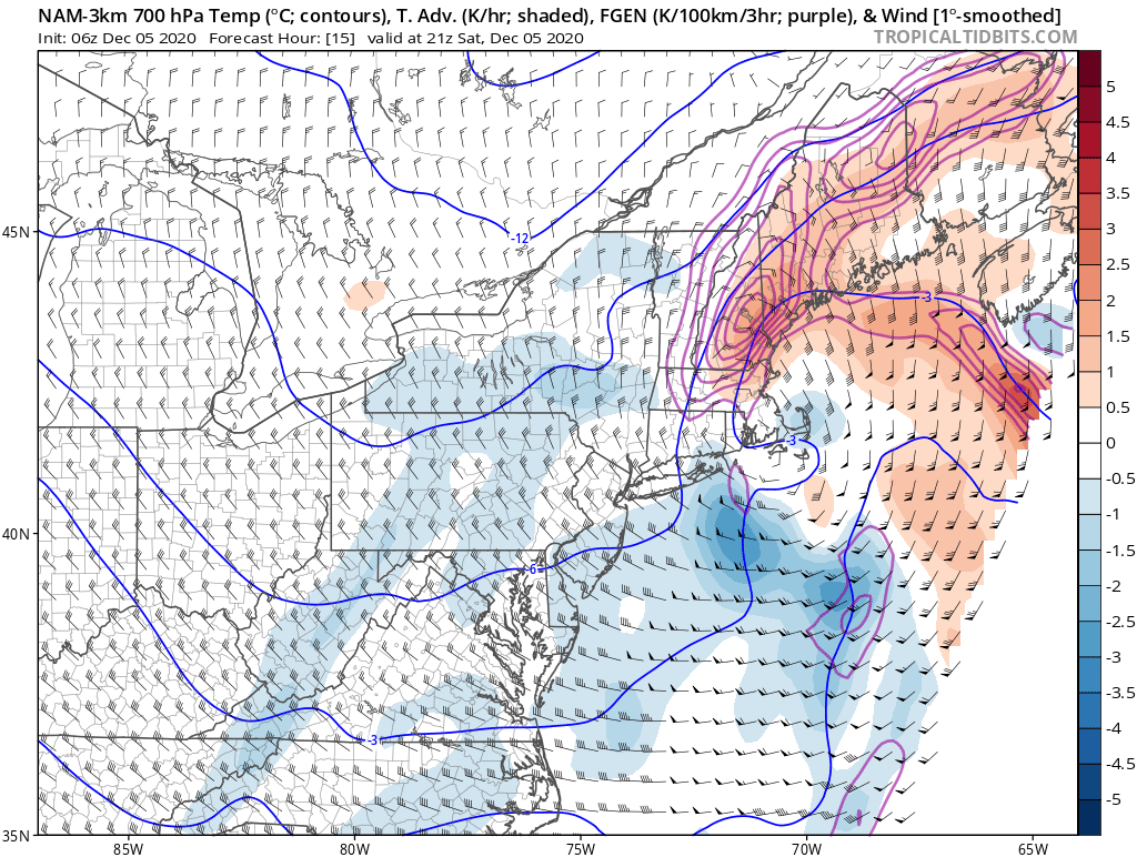
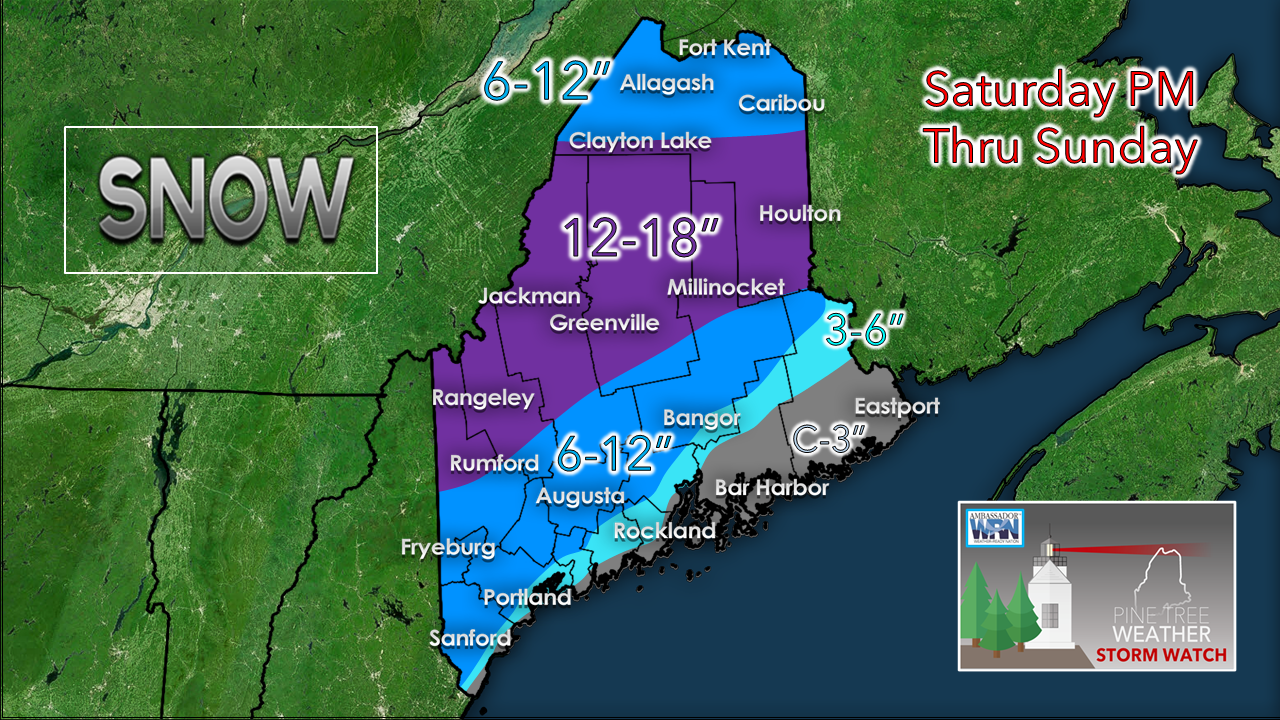
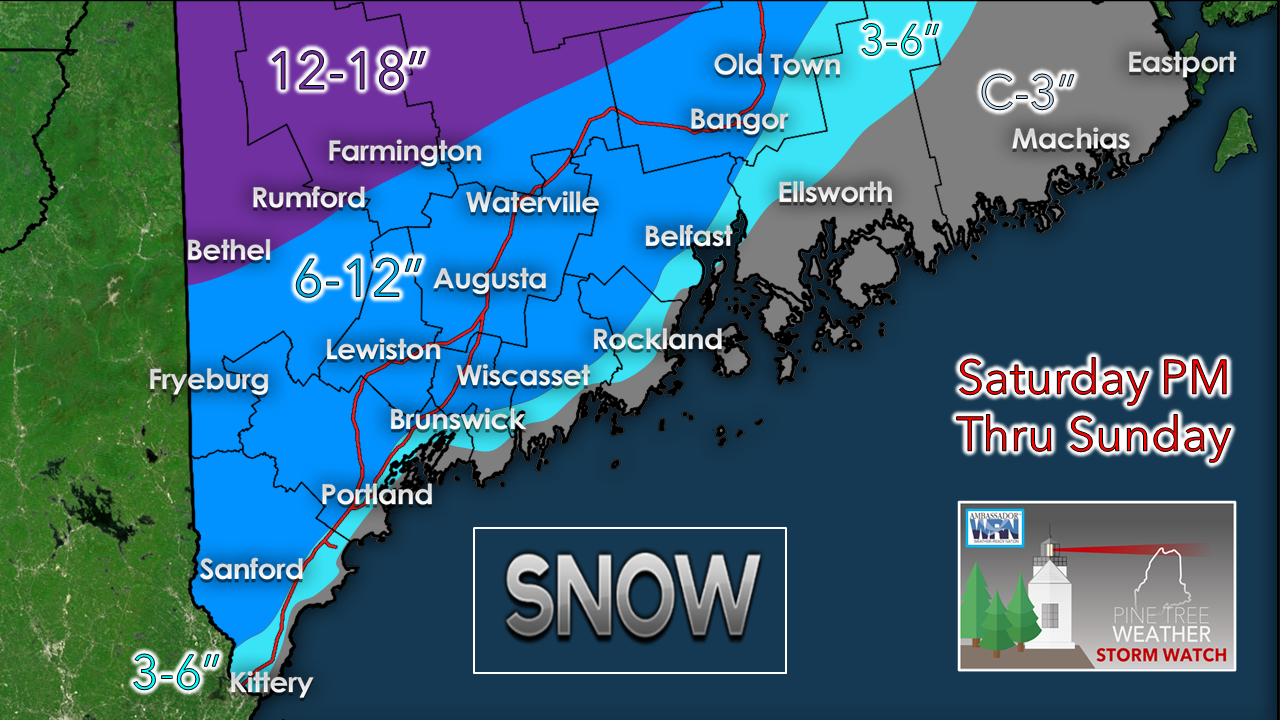
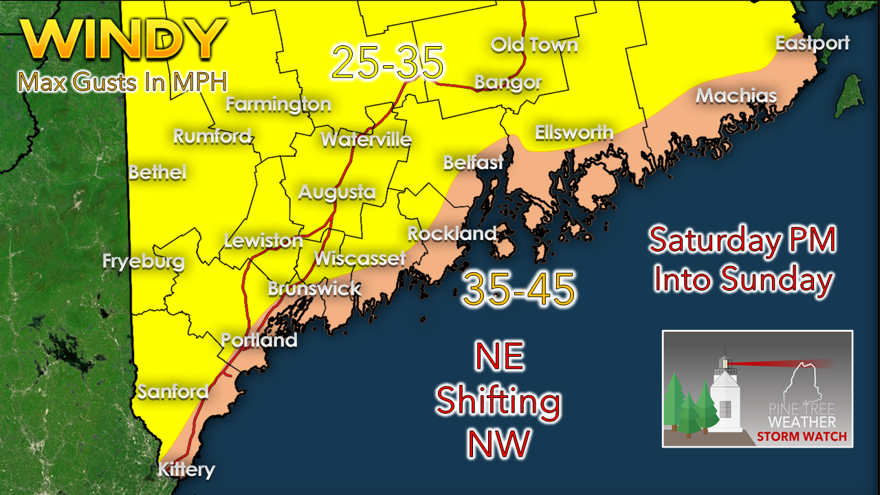
This a complex storm in several ways. Given the storm track into the Gulf of Maine, it sets up different types of precipitation. There is a lot of moisture involved. There is rapid intensification that will qualify this as a bombogenesis event. There is wind, which along with heavy snow could bring power outages. Along with all of that, a razor thin margin of error for snow amounts along the southwest coast.

This is going to be a good storm. Our first significant widespread event of the season. Be ready.

Timing

Picture
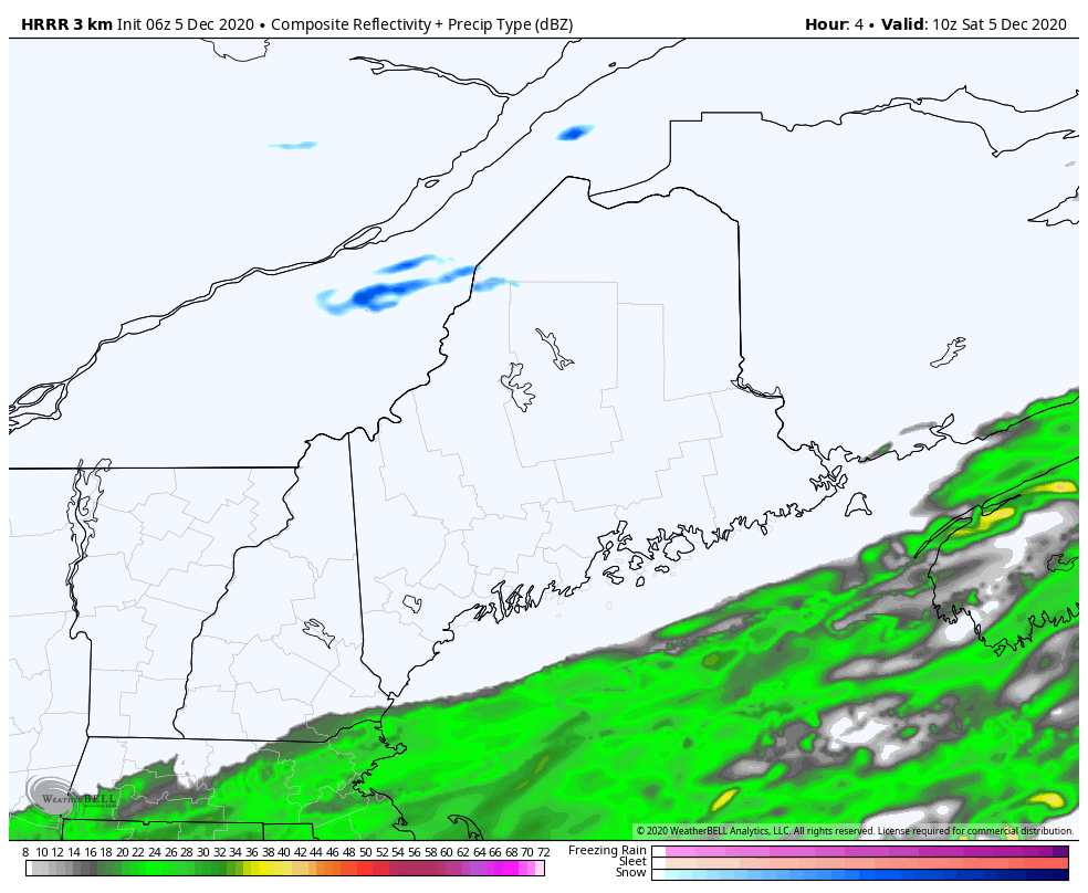
HRRR model idea of radar reflectivity from 5 AM to 7 PM Saturday
The storm starts off as rain in the morning hours. As it intensifies and moves into the Gulf of Maine this afternoon and into tonight, it taps into cold air to the north, and begins the change over to snow.
Picture
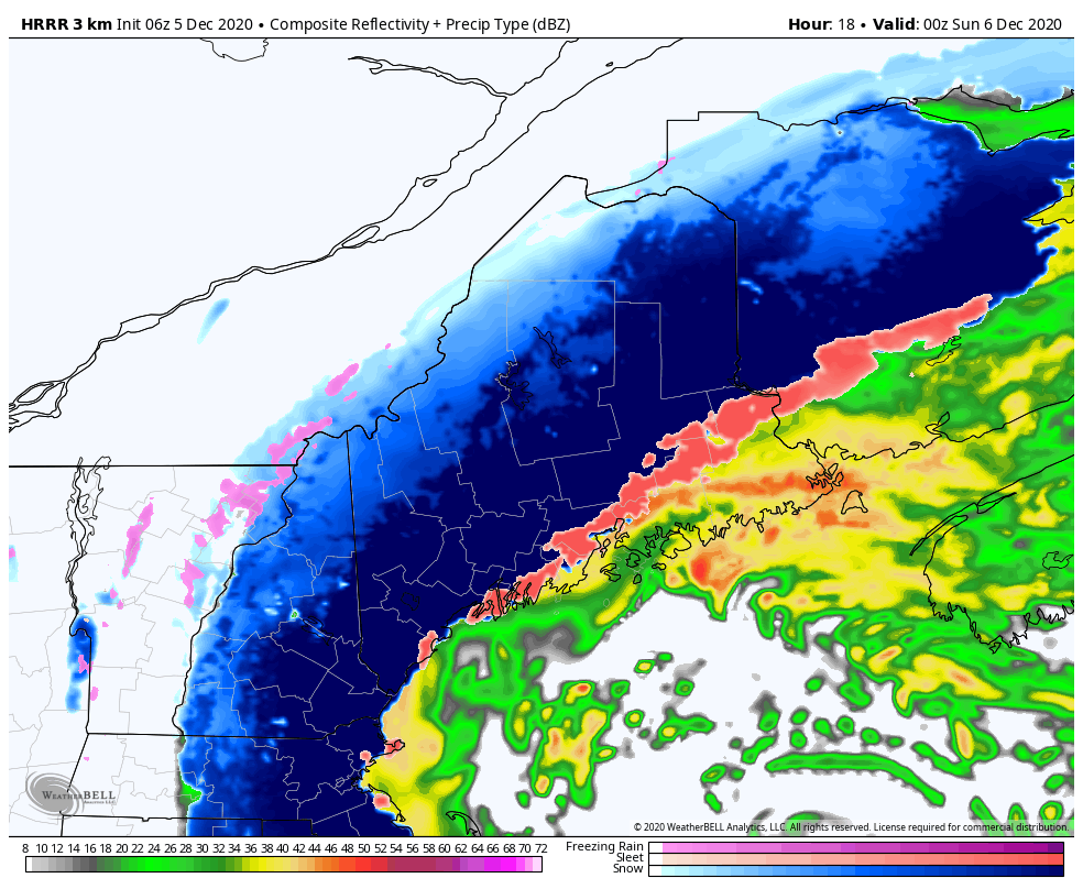
HRRR model idea of radar reflectivity from 7 PM Saturday to 7 AM Sunday
Saturday night, the storm proceeds to the east/northeast. Southern areas appear done with accumulation between 2-4 AM. Heavy snow tapers to snow showers over the western mountains by daylight. Cold air begins to collapse over eastern areas, changing rain to snow.
Picture
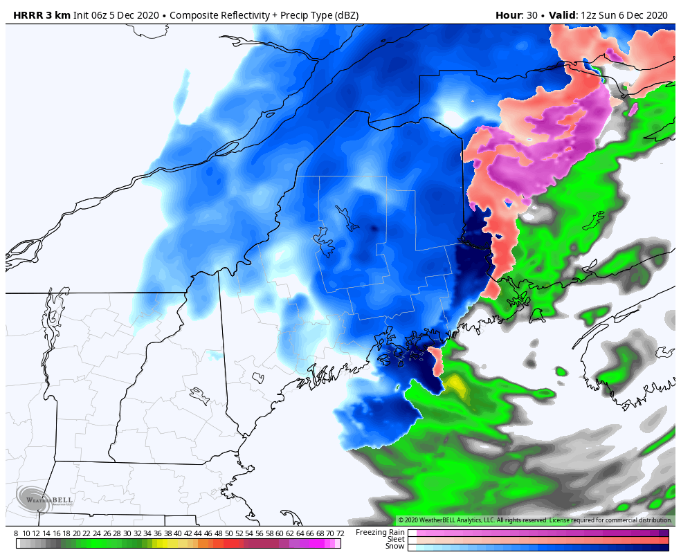
HRRR model idea of radar reflectivity from 7 AM to 7 PM Sunday
The storm continues to move off to the east. The heavier precipitation ends over eastern areas by early afternoon. Strong northwesterly winds generate upslope snow for the higher elevations, which are likely to continue into Sunday night. Central and southern areas see the sun poke through the clouds.

High water content & dynamic cooling
​create a wrench in factoring snow totals

Picture
The subtropical jet is going to deliver the moisture, and plenty of it. The coast gets the higher amount. Whether solid or liquid, or the combination of both, 2" is water is a good bet. Given the recent rains, a flood watch for eastern areas is a good call. For coastal areas west of Penobscot Bay, it will be a matter of how quick the air column cools that will dictate what is solid and what is frozen. 
Picture
Banding will be a key for who gets the dumping of snow over western and southern areas. Frontogenesis / vertical velocity is going to be a big factor, along with temperature.  Where banding sets up, 1-3" per hour snowfall rates are likely to occur. 
Picture
I've adjusted the snowfall idea ever so slightly, focusing the southwest coast.
Picture
Zooming in on that, it shows the very fine line between a minimum of a coating to a maximum of 12". There is a razor thin margin of error here. This is high water content snow. Snow to water ratios with this one will range from 8:1 for the foothills northward, to 4:1 for the coast. Timing of the dynamic cooling of the atmosphere is everything for Bath/Brunswick south to Kittery east of the Turnpike. This could be one of those situations where a waterlogged inch of slop could be had along the beaches, and 3 miles inland could see 4-8" of accumulation. With good snow growth, clumps of snow could fall from the air for a time.

If you absolutely have to travel in this, allow for plenty of extra time. Expect whiteout conditions, extra greasy roads, and difficulty for road crews to keep up where banding occurs. If you get stuck, it may be a while before first responders and a tow truck can get to you. 

Wind and power outages

Picture
The heavy wet snow that I described and wind is a bad combination. There will most likely be power outages, and my concern is some may be dark for several days. The northeast wind is not as much of a concern for me as the northwest wind. The areas that get the banding and heavier snow will see better chance for power outages into the overnight hours and into Sunday.

Picture

​Winter Injuries and Fatalities

Picture
​Slippery sidewalks and roads aren’t the only things to look out for in late winter and early spring snow storms. Shoveling snow can be a health risk as well. Remember to stay hydrated, take frequent breaks, and move only small amounts with each shovel pass. Learn more at weather.gov/winter

Outlook & temperatures through Friday

Good news is no storms of any widespread impacts appear to happen until maybe late next weekend. Folks who reside in interior areas should be diligent in snow removal as the heavy wet snow is likely to turn to cement. If you are shoveling, you will need to take your time.  
Picture
Picture
Picture
Picture
Picture

​​Be prepared to receive alerts and stay updated!

Picture
BE PREPARED WITH A NOAA Weather Radio.

​For $20-$40, it could provide important information to you when you need it. The weather bands are standard on most public safety scanners, and newer scanner models. Weather radios can be programmed for auto alert.  Click here for more information.

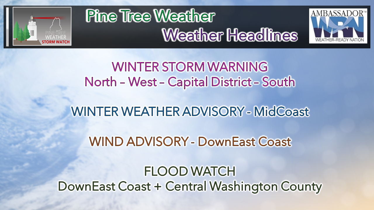
​► ► For the latest official forecasts, bulletins and advisories, please check in with the National Weather Service in Gray for western and southern areas, or Caribou for northern and eastern parts of Maine
Picture

For more information, please follow Pine Tree Weather on Facebook and Twitter. 

** FUNDING NEEDED FOR 2021 **
​Thank you for supporting this community based weather information source that is funded by your financial contributions. 


Stay updated, stay on alert, and stay safe!

​- Mike
Comments
    Picture

    Mike Haggett
    Kennebunk, ME

    Certified Weather
    Forecaster
    Penn State '21

    American Meteorological Society

    National Weather Association

    Weather-Ready Nation 
    Ambassador
    ​
    ​SKYWARN-CWOP

    Matthew 19:26


    Support
    Pine Tree Weather

    DONATE

    Picture

    Picture

    Picture

    Picture

    Picture

    Picture

    Picture

    Picture

    Picture

    Picture

    Archives

    January 2023
    December 2022
    November 2022
    October 2022
    September 2022
    August 2022
    July 2022
    June 2022
    May 2022
    April 2022
    March 2022
    February 2022
    January 2022
    December 2021
    November 2021
    October 2021
    September 2021
    August 2021
    July 2021
    June 2021
    May 2021
    April 2021
    March 2021
    February 2021
    January 2021
    December 2020
    November 2020
    October 2020
    September 2020
    August 2020
    July 2020
    June 2020
    May 2020
    April 2020
    March 2020
    February 2020
    January 2020
    December 2019
    November 2019
    October 2019
    September 2019
    August 2019
    July 2019
    June 2019
    May 2019
    April 2019
    March 2019
    February 2019
    January 2019
    December 2018
    November 2018
    October 2018
    September 2018
    August 2018
    July 2018
    June 2018
    May 2018
    April 2018
    March 2018
    February 2018
    January 2018
    December 2017
    November 2017
    October 2017

    RSS Feed

Proudly powered by Weebly