Very warm with storms arriving this evening, some severe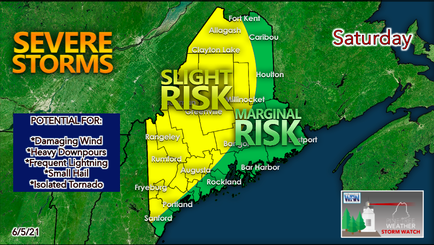 Temperatures on Saturday will climb to the low to mid 80s across much of Maine, giving us a summer-like feel. Areas far north may stay in the upper 70s due to increased cloud cover. With dew points in the mid to high 60s, it will feel quite hot and humid. Coastal locations should feel more comfortable due to a sea breeze keeping temperatures down in the lower 70s. Daytime heating and sufficient moisture make for an increasingly unsettled atmosphere. A weak frontal boundary is expected to pass through on Saturday afternoon, providing a spark for convection and therefore the potential for scattered thunderstorms during the evening. The western mountain areas stretching into central Maine have the greatest risk of seeing storms, while the rest of the state is in the marginal risk category. Damaging wind gusts appear to be the most prominent threat with these storms, along with heavy downpours. Hail is also possible, as well as the chance of an isolated tornado. Always stay alert and check for updates, especially if you plan to be outdoors this afternoon! Timing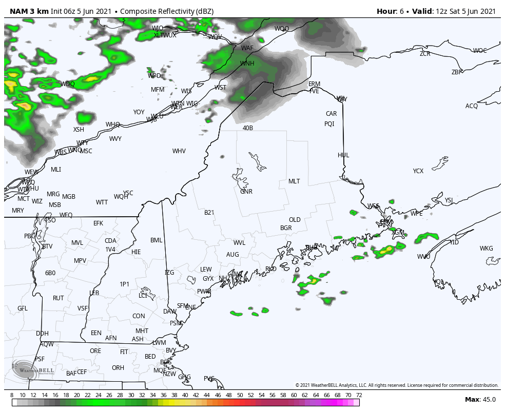 This model shows a future radar loop beginning at 8am Saturday and ending 8pm Saturday evening. Showers are possible in northern areas during the early afternoon. It appears that the stronger storms arrive around 2-4pm in the mountains and last through the evening as they spread through the interior. 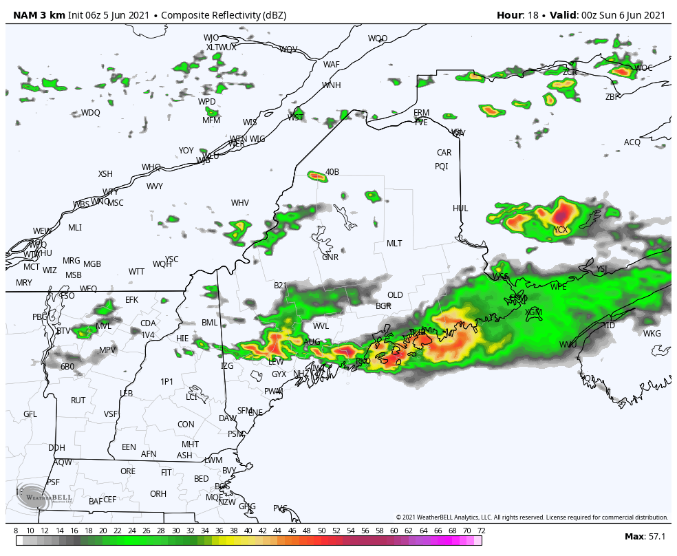 This loop starts at 8pm Saturday and ends at 8am on Sunday. Storms that roll through on late Saturday night should dissipate by Sunday morning. Unstable atmosphere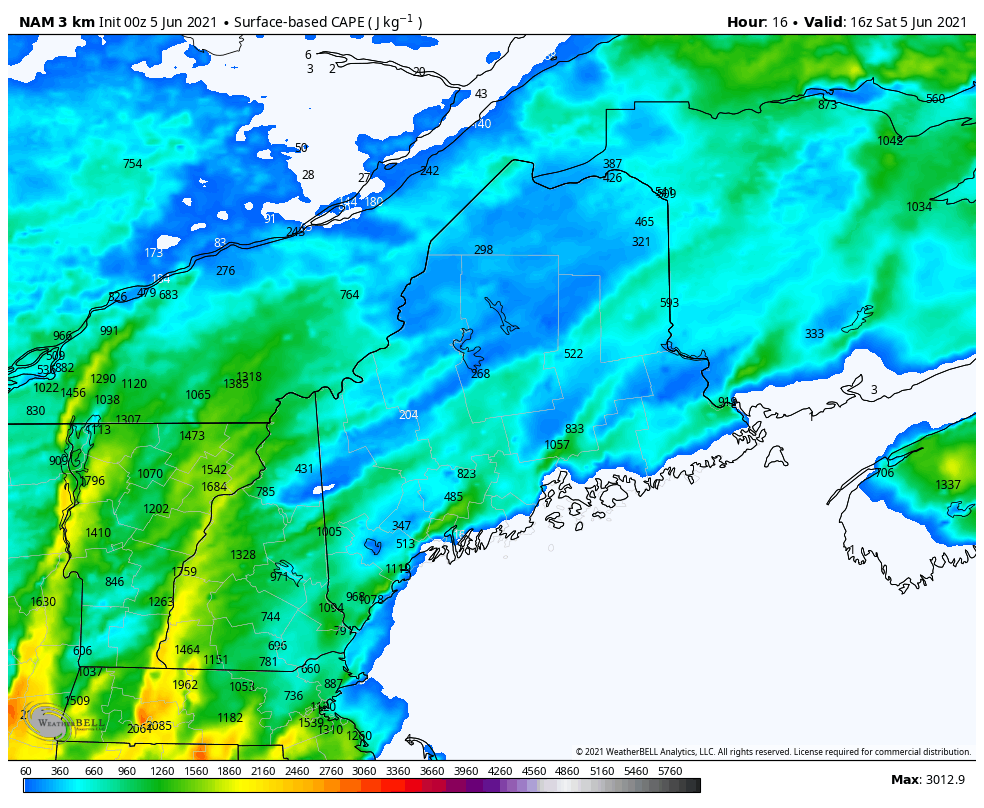 CAPE values between 1000-2500 J/kg represent moderate instability and the presence of strong vertical lift, which is needed for thunderstorms to develop. This model shows the highest CAPE values occurring in the western to southwestern portion of Maine, before spreading northeastward as the evening progresses. These numbers indicate an unstable atmosphere with the potential for severe thunderstorm storms. Potential Impacts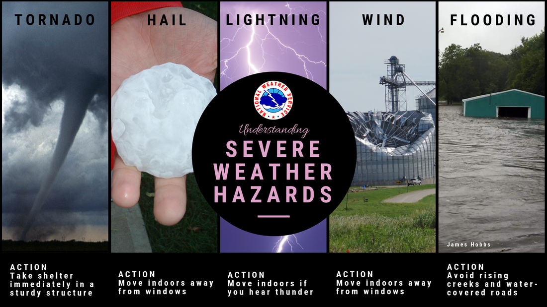 Storms on Saturday could contain gusty winds and heavy downpours. While rain may be welcomed in areas experiencing abnormally dry conditions, high winds come with the risk of power outages and damage to structures. Small hail and a tornado are possible in isolated severe storms. Seek shelter as soon as you hear a rumble of thunder or see a flash of lightning! Severe Thunderstorm Watch vs. Warning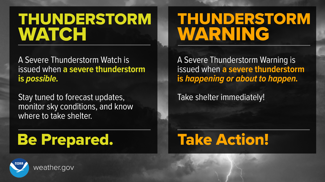 Watches and warnings will likely be issued as the day unfolds. Know the difference between the two and act accordingly: A Severe Thunderstorm WATCH means Be Prepared. Stay informed and be ready to act before severe thunderstorms are possible. A Severe Thunderstorm WARNING means Take Action! Take shelter in a strong building because severe weather is occurring or will occur shortly. For more safety information ► Click here Slight vs. Marginal Risk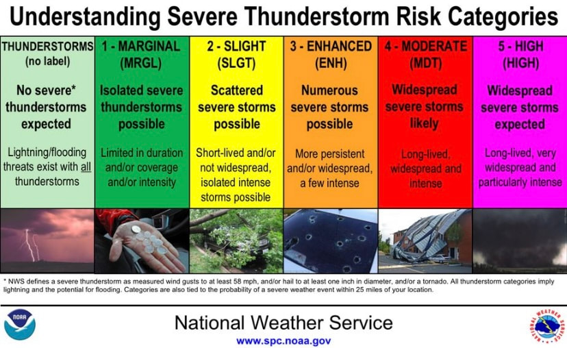 On Saturday, Maine is in both the MARGINAL and SLIGHT risk categories for the convective outlook. This image explains what this means in terms of severe storm risk. Hot on Sunday; heat wave imminent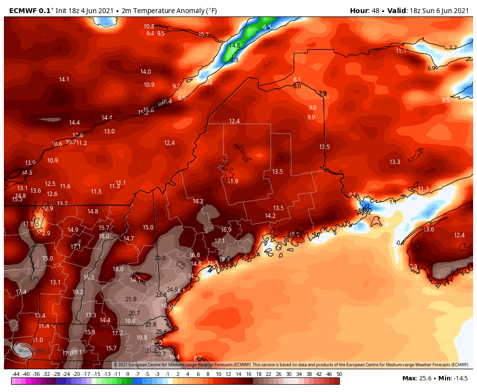 Sunday appears very warm as well, with temperatures possibly creeping into the 90s. A ridge of high pressure builds over the region, allowing a very hot air mass to hang around into the first few days of the work week. This model shows how projected temperatures on Sunday compare to the average. Look out for future updates as record-breaking heat may be in store on Monday. Be prepared to receive alerts and stay updated!
For more information in between posts, please follow Pine Tree Weather on Facebook and Twitter.
Thank you for supporting this community-based weather information source which operates by reader supported financial contributions. Stay updated, stay on alert, and stay safe! |

Mike Haggett
|