Potential for damaging winds, hail, downpours, lightning, and an isolated tornado Saturday evening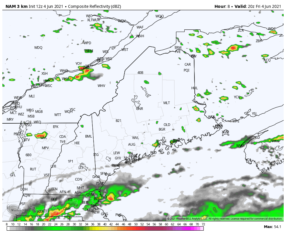 A few scattered showers and thunderstorms initiated by a surface trough moving through will be present this afternoon. However, they would be the hit-or-miss variety with most folks not receiving one. The best chance of a stronger thunderstorm through midafternoon is across interior Downeast Maine. A low-pressure system moves by to our north on Saturday bringing a warm front through the region. Saturday morning will start out sunny across much of the area. Clouds will begin to develop in the mountains of Maine during the afternoon. More widespread thunderstorms are expected Saturday evening with warmer and a more humid air mass present across the region paired with the progression of a frontal boundary through the state. A few locally severe thunderstorms are possible in the mountains and central Maine Saturday night. A cold front will move through our region Saturday night pushing any remaining showers offshore with clearing skies expected. There will be areas of patchy fog present once again across portions of the state. A shower also can't be ruled out for the day on Sunday especially in SW Maine and parts of the coastal regions. 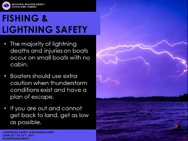 Strong to severe storms are possible for Maine on Saturday. The potential for damaging winds, lightning, and a brief tornado are all possible and can’t be ruled out. A strong northwest flow in the mid-levels with the southwesterly surface flow will create instability in the atmosphere. This will bring a severe weather threat for tomorrow, especially across Northern New Hampshire and into Western Maine. The NWS Storm Prediction Center has a SLIGHT RISK for northwestern Maine with the remainder in a MARGINAL RISK. Gusty winds and heavy rainfall are the primary threats at this time. Some locations Downeast could see stronger storms with hail as the greatest CAPE forms across this area. Timing will be from Saturday late afternoon through late evening, approximately 4 p.m. through 12 am. Folks who are engaged in outdoor activities need to stay aware and be able to get alerts if warranted. Be sure to stay on the lookout for alerts and updates tomorrow morning! Warm summer conditions begin this weekend and into early next week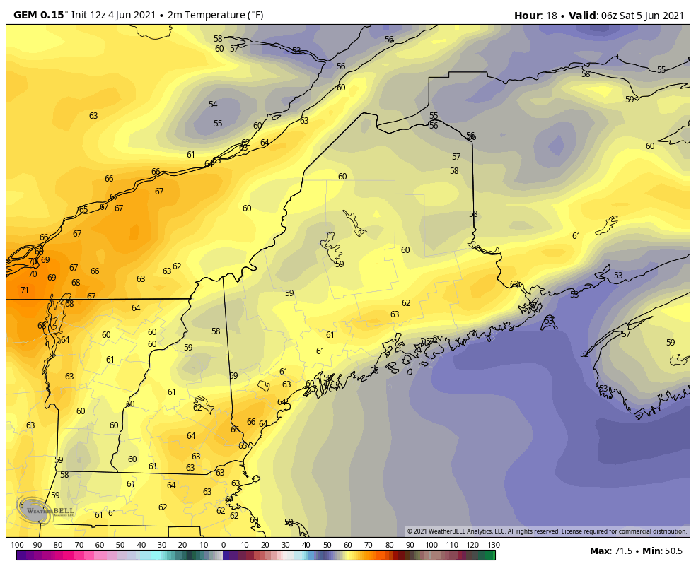 High temperatures for the remainder of today, Friday afternoon, should primarily be in the upper 70’s to lower 80’s. Coastal locations from the South Coast up through Downeast Maine should see high temperatures mainly in the 60’s as the sea breeze boundary continues to move inland. Onshore flow will persist through the night for coastal regions resulting in patchy fog and low temperatures in the 60’s statewide. A southwesterly flow for Saturday will help push temperatures even further as a warm plume will move in from the west. Temperatures will be well into the 80’s with a few spots hitting 90°F values across the southern NH border. The exception will be far north Maine with cloud cover and along the coast where the onshore flow will keep temperatures a bit cooler in the mid to lower 70’s. Saturday night will be the first warm night in our stretch of hot weather with lows ranging from the low to mid 60’s. Sunday will see the return of dry and warm weather as an upper-level ridge builds into the region from the west. Temperatures will climb into the low 90’s across SW Maine with mid to upper 80’s across interior Maine. Westerly winds will restrict the cooling effects of a sea breeze with midcoastal regions warming into the low to mid 80’s. Closer to the coast, winds will turn more onshore limiting highs into the 70’s. Forecasted high temperatures will be running around 20 degrees warmer than average on Sunday and Monday. 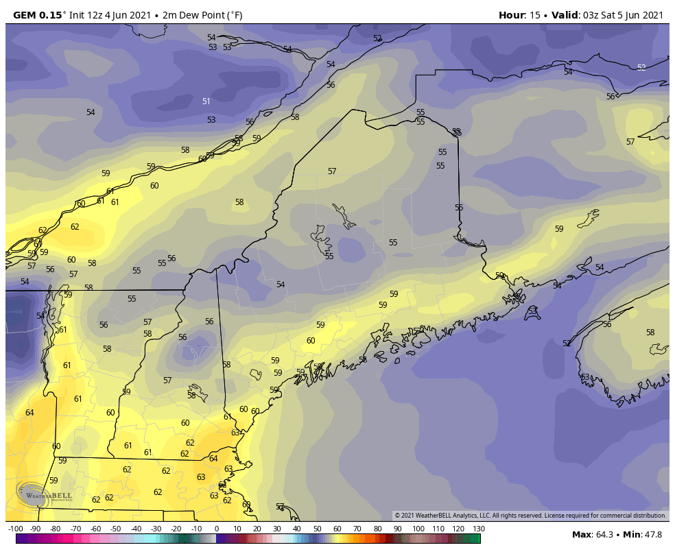 Various levels of sticky humidity for Maine will be present through this weekend and into early next week. The outlook for early next week seems to favor much above average temperatures with highs in the 90’s possible, especially across interior Maine. Several high-temperature records are in jeopardy for Monday as it is expected to be the hottest day of the week. A steady southwest wind will limit the cooling effects of a sea breeze. During this stretch of hot weather, dewpoints will be in the low to mid 60’s which will be humid but not overly oppressive. These dewpoint values will allow for heat indices to be a couple of degrees higher than the air temperature. However, a cold front will drop dewpoint temperatures down to a more comfortable level by mid-week. The next storm system will come after Tuesday and into Wednesday, temperatures will finally cool off later in the week. Dry conditions return 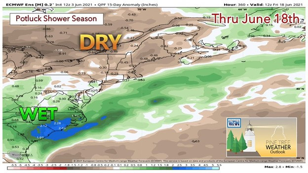 The rainfall outlook for Maine continues to be on the DRY side. Any beneficial rain through mid-June appears to come from small, localized popup showers and storms. This will result in some places seeing higher amounts of rain than others but most seeing little to no rain. Temperatures also appear to be above normal throughout the period. With much above-average temperatures and lower RH values heading into mid-June, we may see an increase in the fire threat to begin next week and last into the middle of June. Please remember to stay updated especially when the drought monitor comes out on Thursdays! Temperature outlook through mid-JuneThe plots below show the trend of the high and low temperatures for Carrabassett, Bangor, Caribou, and Portland over the next week and a half. Temperatures begin to warm up until Monday which is the forecasted warmest day of the week. Warmer nights are also expected for much of the region to begin next week. Record heat is expected for Monday! After a cold front passes by Wednesday, temperatures return closer to average by mid-week with drier and less humid conditions present as well. 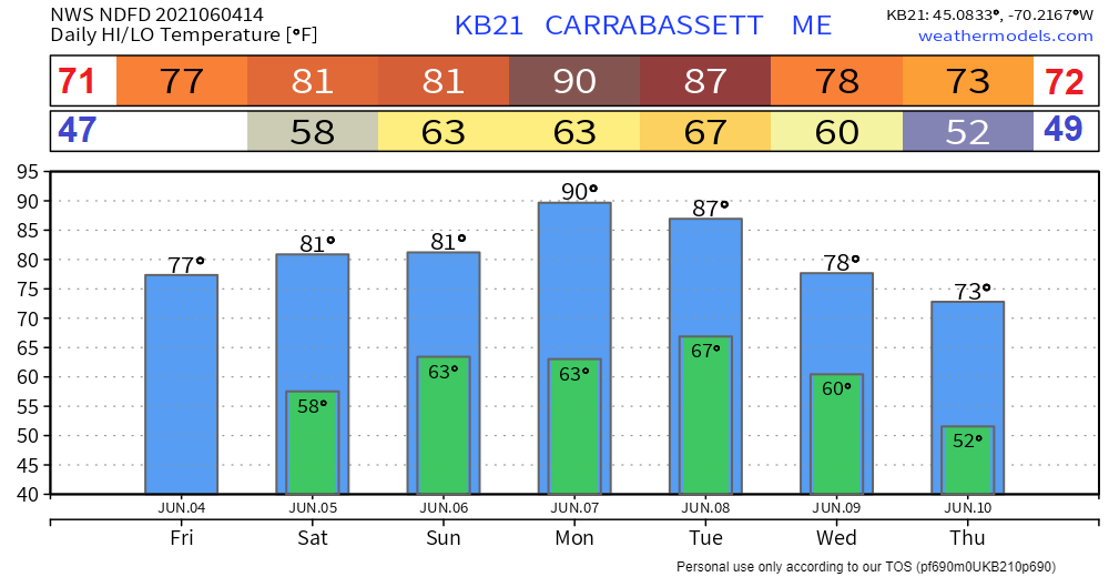 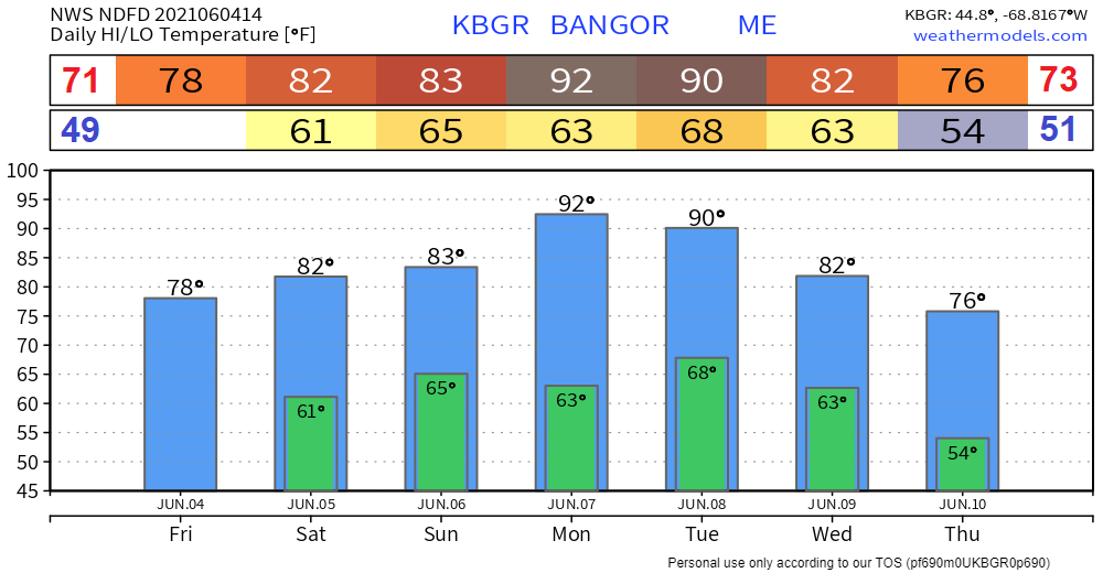 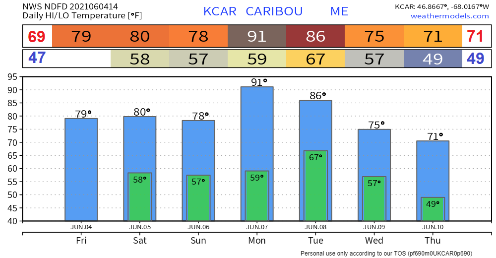 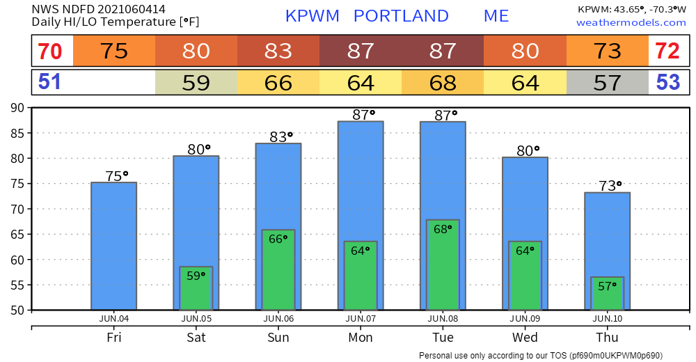 When Thunder Roars Go Indoors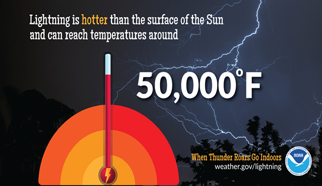 Be aware of forecasts before you head out. There is no safe place outside when thunderstorms are in the area. If you hear thunder, just remember you are likely within striking distance of the storm. WHEN THUNDER ROARS GO INDOORS. Too many people wait too long to get to a safe place when a thunderstorm is approaching, seek shelter immediately. Keep up with the latest NWS forecasts, warnings, and watches. www.weather.gov/safety/lightning Be prepared to receive alerts and stay updated
For more information in between posts, please follow Pine Tree Weather on Facebook and Twitter.
Thank you for supporting this community-based weather information source which operates by reader supported financial contributions. Stay updated, stay on alert, and stay safe! |

Mike Haggett
|