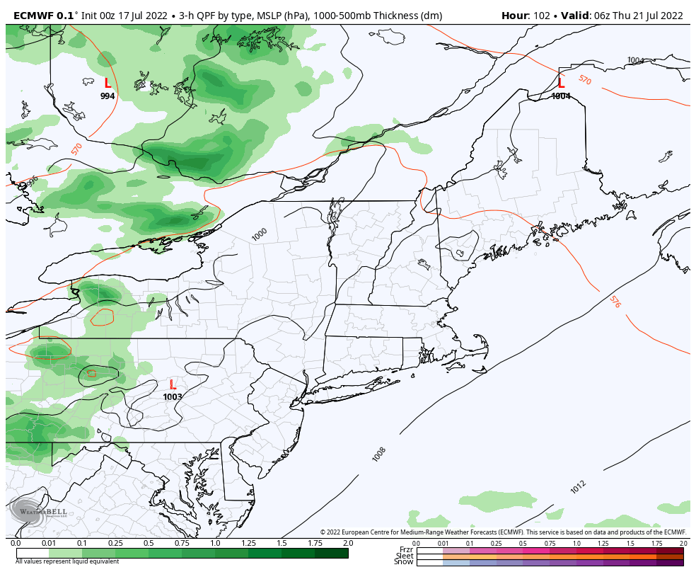
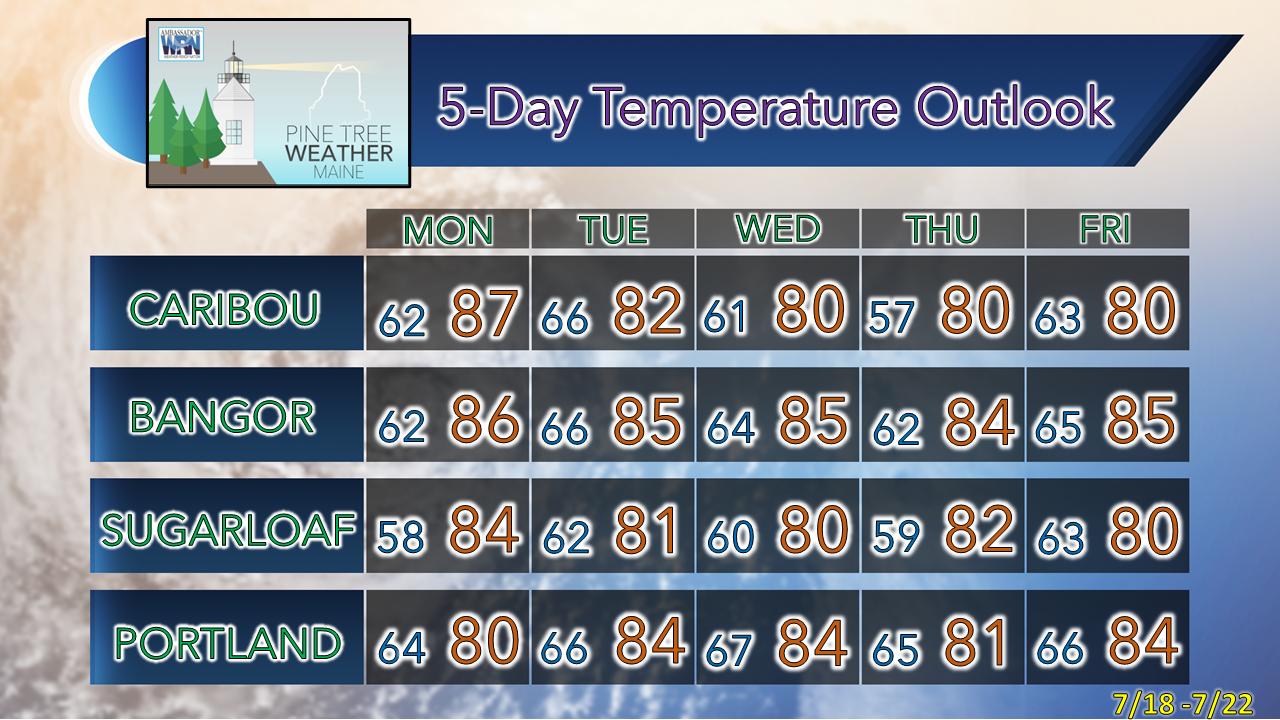
Pine Tree Weather
  • DISCUSSIONS
  • DONATE
  • MAPS
  • NWS BRIEFINGS
  • SATRAD
  • MARINE
  • SNOW / ICE OUTLOOK
  • RAIN OUTLOOK
  • CPC OUTLOOK
  • Kennebunk
  • OBSERVING WEATHER
  • Who We Are
  • My Photography
  • DISCUSSIONS
  • DONATE
  • MAPS
  • NWS BRIEFINGS
  • SATRAD
  • MARINE
  • SNOW / ICE OUTLOOK
  • RAIN OUTLOOK
  • CPC OUTLOOK
  • Kennebunk
  • OBSERVING WEATHER
  • Who We Are
  • My Photography

Summer conditions for the week ahead

7/17/2022

Comments


Ready or not, here it comes

Picture
From under the pier at Old Orchard Beach, my photo
The heat and humidity have held off through the first month of summer around Maine, but that pattern is about to change. While the warmth does not appear to be excessive, the moisture in the air appears to ebb and flow between muggy and soupy for all areas starting Monday and going through Thursday. In this pattern, the chances for showers and thunderstorms increase given the instability provided by the humid air. It will be an eye-to-the-sky week as strong to severe storms are possible Monday and Tuesday, then again on Thursday. It will be important to stay on alert, have multiple ways to receive alerts, and stay updated on the forecast for timing and potential impacts. 

A slight chance of a pop-up shower Sunday

Picture
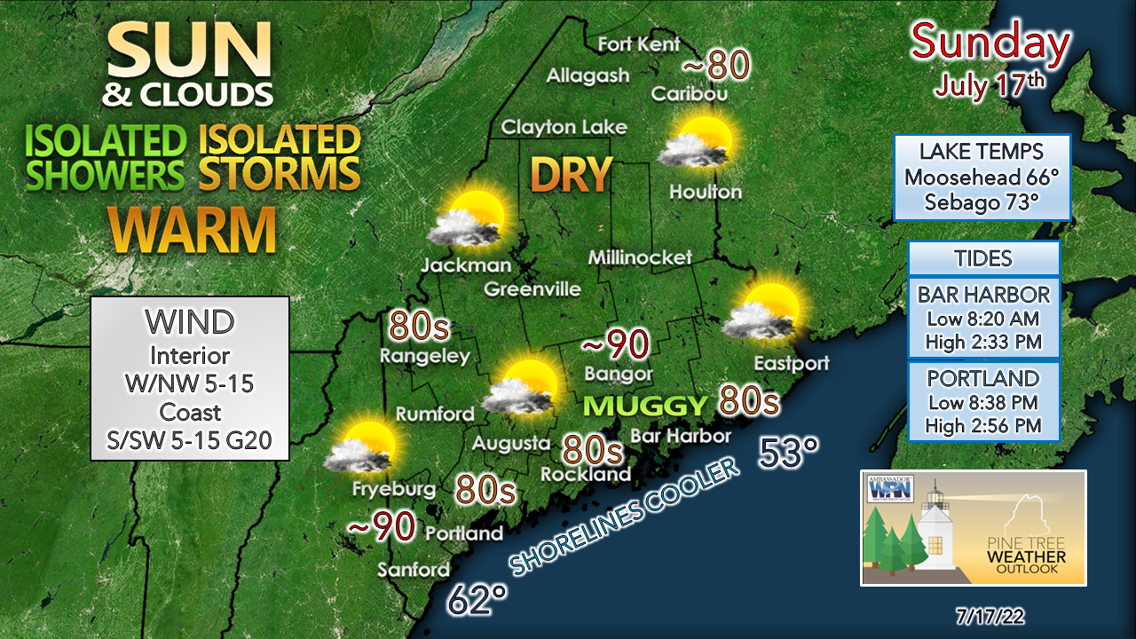
This is an interesting set up for the day as the ocean breeze helps to raise dew points which sets up a boundary with the dry air over the interior. This creates instability and brings the chance for a pop-up shower and/or thunderstorm for the coastal plain in the afternoon into the early evening. Storms appear to be the pulse variety, which would bring a quick dump of rain with some wind and then fizzle out. It may dampen any outdoor dinner plans, so be aware and have a Plan B if necessary, just in case. 

For those heading for the ocean beaches, expect space availability to become cramped as the high tide arrives mid-afternoon. 

Much needed rain on the way Monday into Tuesday

Picture
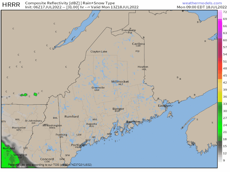
Monday 9 AM to Tuesday 2 AM - Several things going here. First, dew points are likely to surge as upper-level ridging pushes the initial wave into the region and ushers in a tropical feel. With the potential for rain also comes the threat of storms, which could be strong to severe. Storms could bring tropical downpours which could cause localized flash flooding and damaging wind. Guidance is hinting that there could be enough spin in the atmosphere for isolated tornadoes. On top of that, there could be a mesoscale convective system that could develop and continue showers and storms through Monday night and into Tuesday. I can't rule out the potential for nocturnal severe storm potential, which is a rarity in this part of the planet. Stay tuned for updates on this. 

Fingers crossed and prayers sent up that the state gets a good soaking from this to help with the drought conditions. Ideas range from ½-1" with locally heavier amounts as the general rule. 

A cold front approaches Thursday to bring
​temporary relief from humidity

Picture
Thursday 2 AM to Friday 2 PM - A cold front is expected to pass through the region on Thursday and brings the next widespread chance for showers and strong to severe storms. Guidance is hinting at dew points reaching the 70s ahead of this front which would reach air-you-can-wear levels. It's a bit early for finer details here, but it is something to stay updated on. The aftermath is a day with more comfortable humidity levels, but that appears to be temporary as dew points rise back up over the weekend.

​Ah, summer! 

Temperature outlook through Friday

Picture

Thank you for supporting this community-based weather information source which operates by financial contributions from people like you. 
​
Stay updated, stay on alert, and stay safe!

NEXT UPDATE: MONDAY


- Mike

​NOTE: The forecast information depicted on this platform is for general information purposes only for the public and is not designed or intended for commercial use. For those seeking pinpoint weather information for business operations, you should use a private sector source. For information about where to find commercial forecasters to assist your business, please message me and I will be happy to help you.

Comments
    Picture

    Mike Haggett
    Kennebunk, ME

    Certified Weather
    Forecaster
    Penn State '21

    American Meteorological Society

    National Weather Association

    Weather-Ready Nation 
    Ambassador
    ​
    ​SKYWARN-CWOP

    Matthew 19:26


    Support
    Pine Tree Weather

    DONATE

    Picture

    Picture

    Picture

    Picture

    Picture

    Picture

    Picture

    Picture

    Picture

    Picture

    Archives

    January 2023
    December 2022
    November 2022
    October 2022
    September 2022
    August 2022
    July 2022
    June 2022
    May 2022
    April 2022
    March 2022
    February 2022
    January 2022
    December 2021
    November 2021
    October 2021
    September 2021
    August 2021
    July 2021
    June 2021
    May 2021
    April 2021
    March 2021
    February 2021
    January 2021
    December 2020
    November 2020
    October 2020
    September 2020
    August 2020
    July 2020
    June 2020
    May 2020
    April 2020
    March 2020
    February 2020
    January 2020
    December 2019
    November 2019
    October 2019
    September 2019
    August 2019
    July 2019
    June 2019
    May 2019
    April 2019
    March 2019
    February 2019
    January 2019
    December 2018
    November 2018
    October 2018
    September 2018
    August 2018
    July 2018
    June 2018
    May 2018
    April 2018
    March 2018
    February 2018
    January 2018
    December 2017
    November 2017
    October 2017

    RSS Feed

Proudly powered by Weebly