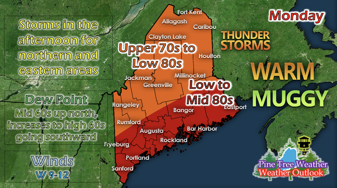
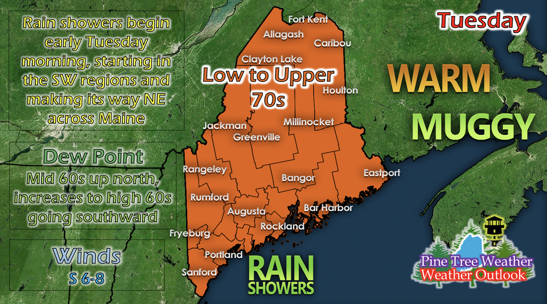
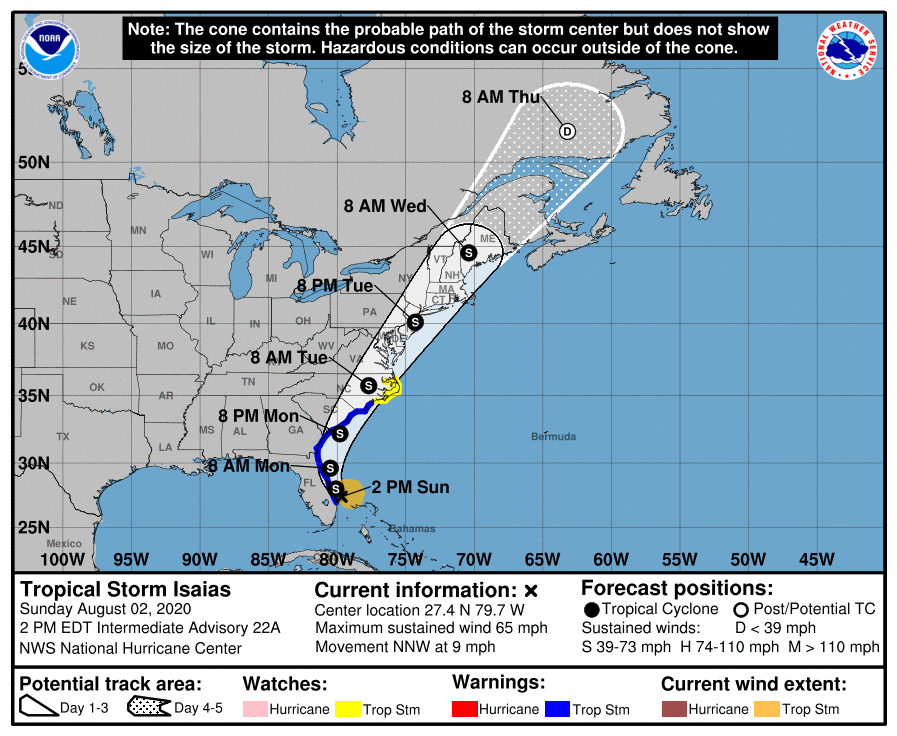
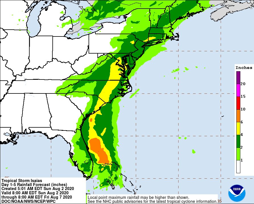
Monday: Warm temperatures and afternoon storms in the northeastA low pressure system tracks through north of Maine on Monday, only really bringing afternoon storms for the northeast regions near Caribou. The rest of the state will feel summertime temperatures; low to mid 80s in the Down East, Mid Coast, Bangor, and Portland regions, and upper 70s to low 80s elsewhere. Dew points remain similar to today's; low to mid 60s up north, and increases as you go southward, to high 60s near the coast. Winds pick up as the cold front moves across the state, blowing westerly and ranging from 9 to 12 mph. Tuesday: Rain showers in the morning starting in the southwest and moving northeasterlyAs Tropical Storm Isaias is still making its way up the East Coast, it will eventually interact with an incoming low pressure system from the west. The actual track of the storm isn't expected to move into Maine until Wednesday, but as these two different systems make their way towards the state, the beginnings of their interaction start Tuesday morning. Rain showers look to move into the Portland and southwestern areas of the state Tuesday morning, and move northeasterly throughout the day as the two systems move closer. Thunderstorms are possible for extreme southwestern areas as the rain showers first begin moving into the state, but should dissipate by the early afternoon. The cold front from the day before keeps temperatures in the low to upper 70s statewide with no defining line of changing temperatures, and dew points are similar to Monday. Tracking Tropical Storm IsaiasSince yesterday's discussion, Isaias has downgraded from a category 1 hurricane to a tropical storm. Although it has downgraded, does not mean it doesn't have any less damage potential. The track has moved slightly since yesterday, and now Isaias looks to move right into the state on 8 AM Wednesday instead of nestling in the coast on the Gulf of Maine. As this system moves closer, expect widespread rain showers with embedded thunderstorms that have the potential to cause flooding, damaging winds, and high surf. The Weather Prediction Center has also released another new rainfall potential map as Isaias continues up the coast. A large swath of Maine remains in the 2 to 4 inch region, and has grown slightly so much of the interior of the state has potential to receive up to 4 inches of rain from this system. The rain will be helpful since Maine has seen drought for a while, but there is potential for flooding since Maine hasn't seen rain up to 4 inches in a day or two in a long time. Hurricane and Tropical Weather Safety One of the greatest impacts of hurricanes and tropical weather is damage to property. Preparing the outside of your home when an impending storm is approaching will save time and money for you after the storm has passed. Use the graphic above as a checklist of sorts to prepare your home for tropical weather rainfall and damaging winds. Help forecast verification, and stay informed!
For more information, please follow Pine Tree Weather on Facebook and Twitter.
Thank you for supporting this community based weather information source that is funded by your financial contributions. Stay updated, stay on alert, and stay safe! Thank you so much for all of your continued support! This is my Venmo if you'd like to contribute: @Kaitlyn-Lardeo Have a great rest of your weekend! - Kaitlyn |
Mike Haggett
|

