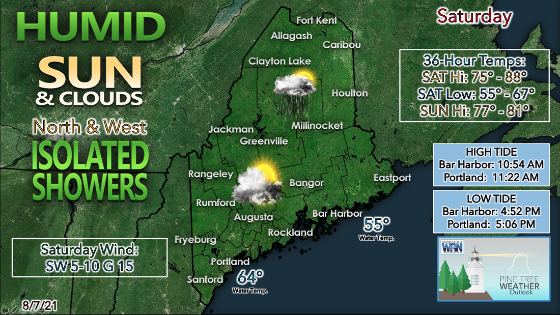
 Get out and enjoy the day on Saturday if you can as it looks to be the better of the two weekend days. Saturday looks to feature a mix of sunshine and clouds throughout the day as a cold front approaches the area from the northwest. This likely brings the chance for some scattered showers and thunderstorms to the western mountains and far northern parts of the state this afternoon. Some of these storms that produce heavy downpours have the chance to produce some gusty winds along with it, so make sure to keep an eye to the sky, especially if you'll be out and about today in the mountains and far north. High temperatures will likely be on the warm side with highs making into the mid to upper 70s along the midcoast thanks to a southwesterly wind, to mid to upper 80s through the coastal plain of southern Maine. High temperatures in the far north and mountains climb into the lower 80s before the showers and storms. If you didn't feel the humidity during the day yesterday, you'll have a better chance of feeling it today. Dew points by Saturday afternoon are expected to climb into the 60s across the state, with lower 60s expected in the mountains and far north, and upper 60s along southern parts of the state. Clouds likely remain over the area Saturday night with any showers and storms that develop over the area coming to an end. Areas of fog are likely to develop once again along the midcoast, with temperatures falling back close to the dew point once again. Low temperatures are likely the coolest in northwestern parts of the state, where they fall back into the upper 50s, whereas the rest of the state falls back into the 60s, with upper 60s expected in southern parts of the state. We'll see a better chance of showers and thunderstorms during the day on Sunday with the cold front passing through the area. There is the potential once again of seeing some gusty winds with some of these storms. The other factor will likely be the movement of these storms, as some of them could be slow moving which could possibly result in some localized flooding where the heavy downpours linger. Once again make sure to keep watch on the radar during the day Sunday if you have any outdoor activities, and make sure to have a plan to get indoors if thunderstorms move into your area. High temperatures on Sunday are likely cooler than they were during the day Saturday thanks to the increase in cloud cover across the region. Highs make it into the upper 70s in the mountains and far north, to lower 80s through the coastal plain. A southeasterly wind along the midcoast will help to keep temperatures a bit cooler there, but highs are still likely to climb into the mid 70s. Dew points on Sunday are likely cooler in far northern parts of the state, with them falling back into the 50s. Places from Bangor south likely remain in the mid and upper 60s, making it feel more uncomfortable during the day Sunday. Be prepared to receive alerts and stay updated!
For more information in between posts, please follow Pine Tree Weather on Facebook and Twitter.
Thank you for supporting this community-based weather information source which operates by reader supported financial contributions. Stay updated, stay on alert, and stay safe! |

Mike Haggett
|