
|
Just a heads up that I am revamping my work processes due to time and season. I've been in the habit of 2-3 AM wake up calls since COVID hit, and I was in school. I am trying to work towards a more realistic schedule and shift back to the afternoon for discussions. The goal is to get an update posted here between 3 - 6 PM, and that focus will be on storm potential, mid to long range outlooks, and any other useful information that I have time for. Expect updates 4-5 times per week here, and daily if the pattern is busy. If I get into a jam, I may drop a quick video update on Facebook. For the non-social media types, you can see what post on Twitter or Facebook without an account. Everything I post is public. When situations warrant with winter storms that a morning update on the day of or during a storm will come. The goal is to get that posted by 5 AM so you folks can make the decisions you need to around travel and how to plan the day. I understand that mornings can be hectic, and there isn't enough time to read. I am trying to switch that around and make it better for everyone, myself included. You may see me stray from the dailies and focus mainly on storm or high impact threats. I think that is my strength, and where I am be of most benefit to you. The graphic you see below takes roughly 30-45 minutes to formulate that could be time spent better on dissecting storms. Focusing exclusively on the weather that brings impacts presented in a way that you won't find elsewhere is what made the site great, and I am going to get back to that. Folks who have recently joined here through Weather of the Kennebunks, my new hyper-local Facebook page, can expect updates there 4-5 times per week. I am in the process of revamping my approach there to balance it out. Please bear with me as I shift things around and get better organized to deliver the best possible product I can. Tuesday outlook, quick thoughts on what is ahead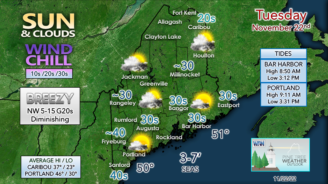 A few early morning snow showers over the north and east are expected to fizzle out by mid-morning. Breezy conditions start off behind the departing cold front diminish over the region by early afternoon. Another weak cold front approaches the region tonight, and snow showers are once again expected for the mountains and north heading into Wednesday morning. Temperatures start off in the teens north to the 20s south, and around 30° along the coast. A bit of a breeze is on tap from the northwest at 5-15 with gusts 20-25 is possible as high pressure moves in for Thanksgiving. There has been a big shift in ideas for Friday. There will be some rain and snow shower activity, but nothing of widespread concern. A potential storm for Sunday is the next feature to watch, and I will update on that here this afternoon. Funding for 2023 is currently at 35%... NOTE: The forecast information depicted on this platform is for general information purposes only for the public and is not designed or intended for commercial use. For those seeking pinpoint weather information for business operations, you should use a private sector source. For information about where to find commercial forecasters to assist your business, please message me and I will be happy to help you |

Mike Haggett
|


